

Saitama, Saitama
Encyclopedia
is the capital and the most populous city
of Saitama Prefecture
in Japan
, situated in the south-east of the prefecture. Its area incorporates the former cities of Urawa
, Ōmiya
, Yono
and Iwatsuki
. It is a city designated by government ordinance. Being in the Greater Tokyo Area
and lying 15 - 30 kilometres north of central Tokyo
, many of its residents commute into Tokyo.
Urawa-ku and Saitama, Ōmiya-ku and Saitama and Yono and Saitama, respectively.
On April 1, 2005, it merged with the city of Iwatsuki to its east, which became a new ward
, Iwatsuki-ku
.
. Within Saitama Prefecture, the location corresponds to the southeastern portion bordered by Ageo City, Hasuda City, and Shiraoka Town to the north; Asaka City, Kawaguchi City, Toda City, and Warabi City to the south; Koshigaya City to the east; Kasukabe City to the northeast; and Kawagoe City, Shiki City, and Fujimi City to the west.
Situated within the Kantō Plain, the city is topographically comprised by lowlands and plateaus, mostly falling below 20 m above sea level, with no mountain ranges or hills within the city boundaries. The western portion of the city lies on the lowland created by the Arakawa River
along with those created by small rivers such as the Moto-Arakawa River, Shiba River
, and Ayase River. The rest of the area mostly resides on the Ōmiya Plateau lying in the north-south direction. Dispersed in this region, major rivers flow southward, almost paralleling to one another.
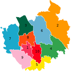 Saitama has ten wards
(ku), which were assigned official colours as of April 2005:
 The economy of the city is basically as one of the commercial centres in the Greater Tokyo Area and as a business centre to serve Saitama Prefecture, North Kantō, and northeast Honshū.
Manufacturing includes automotive (Honda manufactures the Honda Legend
here), food, optical, precision and pharmaceutical products. Iwatsuki
is famous for manufacturing of hinamatsuri
dolls and ornate kabuto
(samurai
helmets).
for both passengers and freight.
Ōmiya Station
, part of the Shinkansen
high-speed train network, serves as the biggest railway hub in the prefecture. The Musashino
and Saitama Railway
lines offer connections at other stations. The Shuto
, Tokyo Gaikan
and Tōhoku
expressways
serve the city. National Highway
Routes 16, 17, 122, 298 and 463 also serve the city.
The closest major airports are Haneda Airport
and Narita International Airport
, both about two hours away. Honda Airport
in Okegawa
is for general aviation
and offers no scheduled transport services. Commuter helicopter flights to Narita Airport are offered from Kawajima
.
Saitama Railway Corporation
Tobu Railway
Saitama New Urban Transit
backed by the Liberal Democratic Party
and Komeito
. On May 24, 2009 Aikawa lost his bid for reelection against Hayato Shimizu who was backed by the opposition DPJ
. The city assembly of Saitama has 64 elected members.
football (soccer)
teams: the popular Urawa Red Diamonds
, formerly owned by Mitsubishi
, and Omiya Ardija
, formerly owned by NTT
.
The city and Tokorozawa
are home to the Japan Professional Basketball
League team the Saitama Broncos
.
for details.
in the northern part of what is now known as Saitama Prefecture. "Sakitama" has an ancient history and is mentioned in the famous 8th century poetry anthology Man'yōshū. The pronunciation has changed from Sakitama to Saitama over the years.
With the merger of Urawa
, Ōmiya
, and Yono
it was decided that a new name, one fitting for this newly-created prefectural capital, was needed. The prefectural name "Saitama" (埼玉県) was changed from kanji
into hiragana
, thus Saitama City (さいたま市) was born. It is the only prefectural capital in Japan whose name is always written in hiragana, and belongs to the list of hiragana cities.
However, Saitama written in hiragana (さいたま市) actually finished in second place in public polling to Saitama written in kanji (埼玉市). Despite this, government officials decided to name the new city Saitama in hiragana, not kanji. In third place in the poll was Ōmiya (大宮市). In fourth was Saitama (彩玉市), written with an alternative kanji for "sai" (彩) which means "colorful". The "sai" (埼) used in the prefectural name is a rare form of a common character (崎) that means cape or promontory.
Toluca
, Mexico
(1979) Zhengzhou
, China
(1981) Hamilton
, New Zealand
(1984) Richmond
, Virginia
, United States
(1994) Nanaimo
, British Columbia
, Canada
(1996) Pittsburgh
, Pennsylvania
, United States
(1998)
Cities of Japan
||A is a local administrative unit in Japan. Cities are ranked on the same level as and , with the difference that they are not a component of...
of Saitama Prefecture
Saitama Prefecture
is a prefecture of Japan located in the Kantō region of the island of Honshu. The capital is the city of Saitama.This prefecture is part of the Greater Tokyo Area, and most of Saitama's cities can be described as suburbs of Tokyo, to which a large amount of residents commute each day.- History...
in Japan
Japan
Japan is an island nation in East Asia. Located in the Pacific Ocean, it lies to the east of the Sea of Japan, China, North Korea, South Korea and Russia, stretching from the Sea of Okhotsk in the north to the East China Sea and Taiwan in the south...
, situated in the south-east of the prefecture. Its area incorporates the former cities of Urawa
Urawa, Saitama
was a city in Saitama Prefecture, Japan, until it merged into the city of Saitama together with two other cities, Omiya and Yono, on May 1, 2001. In 2003, the former area of Urawa became Urawa-ku, Midori-ku, Minami-ku, and Sakura-ku, which are wards of the city of Saitama...
, Ōmiya
Omiya-ku, Saitama
is a ward of Saitama city, Saitama Prefecture, Japan. It is in the Greater Tokyo Area and about 25 km north of central Tokyo. Ōmiya-ku is surrounded by Nishi-ku , Kita-ku , Minuma-ku , Urawa-ku , Chūō-ku , and Sakura-ku of Saitama city.Ōmiya-ku is the most active commercial and business centre in...
, Yono
Yono, Saitama
was a city in Saitama Prefecture, Japan. The town of Yono began on April 1, 1889. On July 15, 1958, Yono became a city. The city existed between cities of Urawa and Ōmiya. On May 1, 2001 it merged with Ōmiya and Urawa to form the new capital City of Saitama...
and Iwatsuki
Iwatsuki-ku, Saitama
is a ward of Saitama City, Saitama Prefecture, Japan since April 1, 2005 when the city of Iwatsuki was incorporated into Saitama City.-Population and area:The first population count was held on July 1, 2006 and the ward had an estimated population of 111,723...
. It is a city designated by government ordinance. Being in the Greater Tokyo Area
Greater Tokyo Area
The Greater Tokyo Area is a large metropolitan area in Kantō region, Japan, consisting of most of the prefectures of Chiba, Kanagawa, Saitama, and Tokyo . In Japanese, it is referred to by various terms, including the , , and others....
and lying 15 - 30 kilometres north of central Tokyo
Tokyo
, ; officially , is one of the 47 prefectures of Japan. Tokyo is the capital of Japan, the center of the Greater Tokyo Area, and the largest metropolitan area of Japan. It is the seat of the Japanese government and the Imperial Palace, and the home of the Japanese Imperial Family...
, many of its residents commute into Tokyo.
History
The city was founded on May 1, 2001, and was designated on April 1, 2003 as a government ordinance. For the histories of Urawa, Ōmiya and Yono before the merger, seeUrawa-ku and Saitama, Ōmiya-ku and Saitama and Yono and Saitama, respectively.
On April 1, 2005, it merged with the city of Iwatsuki to its east, which became a new ward
Wards of Japan
A is a subdivision of one of the cities of Japan that is large enough to have been designated by government ordinance. Wards are used to subdivide each city designated by government ordinance...
, Iwatsuki-ku
Iwatsuki-ku, Saitama
is a ward of Saitama City, Saitama Prefecture, Japan since April 1, 2005 when the city of Iwatsuki was incorporated into Saitama City.-Population and area:The first population count was held on July 1, 2006 and the ward had an estimated population of 111,723...
.
Geography
The city is located 20 to 30 km north of central Tokyo, roughly at the center of the Kantō PlainKanto Plain
The ' is the largest plain in Japan located in the Kanto Region of central Honshū. The total area 17,000 sq km covers more than half of the Region extending over Tokyo, Saitama Prefecture, Kanagawa Prefecture, Chiba Prefecture, Gunma Prefecture, and Tochigi Prefecture.The northern limit borders on...
. Within Saitama Prefecture, the location corresponds to the southeastern portion bordered by Ageo City, Hasuda City, and Shiraoka Town to the north; Asaka City, Kawaguchi City, Toda City, and Warabi City to the south; Koshigaya City to the east; Kasukabe City to the northeast; and Kawagoe City, Shiki City, and Fujimi City to the west.
Situated within the Kantō Plain, the city is topographically comprised by lowlands and plateaus, mostly falling below 20 m above sea level, with no mountain ranges or hills within the city boundaries. The western portion of the city lies on the lowland created by the Arakawa River
Arakawa River
The is one of the principal rivers flowing through Tokyo, the capital city of Japan. The point of origin is on Mount Kobushi in Saitama Prefecture, and the Arakawa River empties into Tokyo Bay, spanning 173 kilometers. The drainage basin covers 2,940 square kilometers...
along with those created by small rivers such as the Moto-Arakawa River, Shiba River
Shiba River
The is a tributary of the Arakawa River that mainly runs through the eastern part of Saitama Prefecture. The river has and in Okegawa, Saitama as points of origin and flows through Ageo, Minuma and Kawaguchi, and connects to the Arakawa River.-History:...
, and Ayase River. The rest of the area mostly resides on the Ōmiya Plateau lying in the north-south direction. Dispersed in this region, major rivers flow southward, almost paralleling to one another.
Wards
Wards of Japan
A is a subdivision of one of the cities of Japan that is large enough to have been designated by government ordinance. Wards are used to subdivide each city designated by government ordinance...
(ku), which were assigned official colours as of April 2005:
| ■1 - Chūō-ku Chuo-ku, Saitama is a ward of Saitama City, Japan. It is surrounded by Sakura-ku , Minami-ku , Urawa-ku and Ōmiya-ku of Saitama city.It is a part of the Greater Tokyo Area and located about 20 kilometres north of central Tokyo.... |
中央区 | (Rose red) |
| ■2 - Iwatsuki-ku Iwatsuki-ku, Saitama is a ward of Saitama City, Saitama Prefecture, Japan since April 1, 2005 when the city of Iwatsuki was incorporated into Saitama City.-Population and area:The first population count was held on July 1, 2006 and the ward had an estimated population of 111,723... |
岩槻区 | (Ochre) |
| ■3 - Kita-ku Kita-ku, Saitama is a ward of Saitama city, Saitama Prefecture, Japan, occupying the northern part of the city. It is surrounded by Minuma-ku , Ōmiya-ku , Nishi-ku of Saitama city and Ageo city .-History:... |
北区 | (Dark green) |
| ■4 - Midori-ku Midori-ku, Saitama is one of the ten wards of Saitama located in Saitama Prefecture, Japan.-Geography:Midori-ku is located at the south-eastern corner and covers an area part of former Misono Village and an eastern section of former Urawa City. A wide area of green farmland, Minuma Rice Paddies, forms the central... |
緑区 | (Green) |
| ■5 - Minami-ku Minami-ku, Saitama is one of the ten wards of Saitama located in Saitama Prefecture, Japan.On April 1, 1889, various mergers took place in Kitaadachi District. On the same date in 1932, further mergers resulted in the formation of the town of Urawa. This town became a city with the same name in 1934... |
南区 | (Lemon yellow) |
| ■6 - Minuma-ku Minuma-ku, Saitama is a ward of Saitama City, Saitama Prefecture, Japan, occupying the northeastern part of the city. It is surrounded by Iwatsuki-ku , Midori-ku , Urawa-ku , Ōmiya-ku , Kita-ku of Saitama city and cities of Ageo and Hasuda .-History:Until May 1, 2001 it was an eastern part of Ōmiya city... |
見沼区 | (Sky blue) |
| ■7 - Nishi-ku Nishi-ku, Saitama is one of the ten wards of Saitama located in Saitama Prefecture, Japan.-External links:*... |
西区 | (Blue) |
| ■8 - Ōmiya-ku Omiya-ku, Saitama is a ward of Saitama city, Saitama Prefecture, Japan. It is in the Greater Tokyo Area and about 25 km north of central Tokyo. Ōmiya-ku is surrounded by Nishi-ku , Kita-ku , Minuma-ku , Urawa-ku , Chūō-ku , and Sakura-ku of Saitama city.Ōmiya-ku is the most active commercial and business centre in... |
大宮区 | (Orange) |
| ■9 - Sakura-ku Sakura-ku, Saitama is a ward of Saitama City, Saitama Prefecture, Japan, occupying the southwestern part of the city. It is surrounded by Nishi-ku, Ōmiya-ku , Chūō-ku , Minami-ku of Saitama city and cities of Asaka, Shiki and Fujimi .... |
桜区 | (Cherry blossom pink) |
| ■10 - Urawa-ku Urawa-ku, Saitama is a ward of Saitama City, Japan. It is surrounded by Midori-ku , Minami-ku , Chūō-ku , Ōmiya-ku , and Minuma-ku of Saitama city.... |
浦和区 | (Red) - administrative center |
Economy
Manufacturing includes automotive (Honda manufactures the Honda Legend
Honda Legend
The Honda Legend is a mid-size luxury car made by the Japanese automaker Honda. It was the result of Project XX, a joint agreement started in November 1981 with the Austin Rover Group of Great Britain and was mechanically related to the Rover 800 series....
here), food, optical, precision and pharmaceutical products. Iwatsuki
Iwatsuki-ku, Saitama
is a ward of Saitama City, Saitama Prefecture, Japan since April 1, 2005 when the city of Iwatsuki was incorporated into Saitama City.-Population and area:The first population count was held on July 1, 2006 and the ward had an estimated population of 111,723...
is famous for manufacturing of hinamatsuri
Hinamatsuri
The Japanese , or Girls' Day, is held on March 3. Platforms covered with a red carpet are used to display a set of representing the Emperor, Empress, attendants, and musicians in traditional court dress of the Heian period.- Origin and customs :...
dolls and ornate kabuto
Kabuto
A kabuto is a helmet used with traditional Japanese armour as worn by the samurai class and their retainers in feudal Japan....
(samurai
Samurai
is the term for the military nobility of pre-industrial Japan. According to translator William Scott Wilson: "In Chinese, the character 侍 was originally a verb meaning to wait upon or accompany a person in the upper ranks of society, and this is also true of the original term in Japanese, saburau...
helmets).
Transportation
Saitama is a regional transportation hubTransportation hub
A transport hub is a place where passengers and cargo are exchanged between vehicles or between transport modes. Public transport hubs include train stations, rapid transit stations, bus stops, tram stop, airports and ferry slips. Freight hubs include classification yards, seaports and truck...
for both passengers and freight.
Ōmiya Station
Omiya Station (Saitama)
is a railway station in Ōmiya-ku, Saitama, Japan. It is a major interchange station for the East Japan Railway Company .-JR East:* Tōhoku Shinkansen* Akita Shinkansen* Yamagata Shinkansen* Jōetsu Shinkansen* Nagano Shinkansen...
, part of the Shinkansen
Shinkansen
The , also known as THE BULLET TRAIN, is a network of high-speed railway lines in Japan operated by four Japan Railways Group companies. Starting with the Tōkaidō Shinkansen in 1964, the network has expanded to currently consist of of lines with maximum speeds of , of Mini-shinkansen with a...
high-speed train network, serves as the biggest railway hub in the prefecture. The Musashino
Musashino Line
The is a railway line operated by the East Japan Railway Company . It links Tsurumi Station in Yokohama with Nishi-Funabashi Station in Chiba Prefecture, forming a 100.6 km unclosed loop around central Tokyo...
and Saitama Railway
Saitama Rapid Railway Line
The is the continuation of the Namboku Line, starting at Akabane-Iwabuchi station in Tokyo and ending at Urawa Misono Station in Saitama. It was completed on March 28, 2001....
lines offer connections at other stations. The Shuto
Shuto Expressway
is a network of toll expressways in the Greater Tokyo Area of Japan. It is operated and maintained by the .Most routes consist of elevated roadway above other roads or over water, and have many sharp curves which require caution to drive safely...
, Tokyo Gaikan
Tokyo Gaikan Expressway
The is a national expressway in Japan. It is owned and operated by East Nippon Expressway Company.-Overview:The name Gaikan refers to the route's status as an outer ring road for Tokyo. The expressway is also referred to simply as Gaikan for short...
and Tōhoku
Tohoku Expressway
The is a national expressway in Japan. It is owned by Japan Expressway Holding and Debt Repayment Agency and operated by East Nippon Expressway Company.-Naming:Tōhoku refers to the Tōhoku region, the northernmost region on the island of Honshū....
expressways
Expressways of Japan
The expressways of Japan make up a large network of freeway-standard toll roads.- History :Following World War II, Japan's economic revival led to a massive increase in personal automobile use...
serve the city. National Highway
National highways of Japan
Japan has a nationwide system of distinct from the expressways. The Ministry of Land, Infrastructure and Transport and other government agencies administer the national highways. Beginning in 1952, Japan classified these as Class 1 or Class 2. Class 1 highways had one- or two-digit numbers, while...
Routes 16, 17, 122, 298 and 463 also serve the city.
The closest major airports are Haneda Airport
Tokyo International Airport
, commonly known as , is one of the two primary airports that serve the Greater Tokyo Area in Japan. It is located in Ōta, Tokyo, south of Tokyo Station....
and Narita International Airport
Narita International Airport
is an international airport serving the Greater Tokyo Area of Japan. It is located east of Tokyo Station and east-southeast of Narita Station in the city of Narita, and the adjacent town of Shibayama....
, both about two hours away. Honda Airport
Honda Airport
is a private airfield in the town of Kawajima, Hiki District, and the city of Okegawa, both in Saitama Prefecture, Japan. Another name for it is Okegawa Airfield. The operator is Honda Airways, a subsidiary of Honda Motor Co. Ltd.-Data:...
in Okegawa
Okegawa, Saitama
is a city located in Saitama, Japan. It was founded on November 3, 1970, and as of 2003, the city has an estimated population of 73,881 and the density of 2,924.82 persons per km²...
is for general aviation
General aviation
General aviation is one of the two categories of civil aviation. It refers to all flights other than military and scheduled airline and regular cargo flights, both private and commercial. General aviation flights range from gliders and powered parachutes to large, non-scheduled cargo jet flights...
and offers no scheduled transport services. Commuter helicopter flights to Narita Airport are offered from Kawajima
Kawajima, Saitama
is a town located in Hiki District, Saitama, Japan.As of 2003, the town has an estimated population of 23,028 and a density of 551.97 persons per km². The total area is 41.72 km².-External links:*...
.
Railway Stations
East Japan Railway CompanyEast Japan Railway Company
is the largest passenger railway company in the world and one of the seven Japan Railways Group companies. The company name is officially abbreviated as JR East in English, and as in Japanese. The company's headquarters are in Yoyogi, Shibuya, Tokyo....
- TōhokuTohoku ShinkansenThe is a Japanese high-speed Shinkansen rail line, connecting Tokyo with Aomori in Aomori Prefecture for a total length of 674 km, Japan's longest Shinkansen line. It runs through the more sparsely populated Tōhoku region of Japan's main island Honshu. It has two spur lines, Yamagata...
, AkitaAkita ShinkansenThe is a Mini-shinkansen high-speed rail line in Japan. Serving the Kantō and Tōhoku Regions of the country, it links Tokyo and Akita in Akita prefecture with direct service. From Tokyo to Morioka in Iwate prefecture, it operates on the Tōhoku Shinkansen tracks. From there to Ōmagari, it uses the...
, YamagataYamagata ShinkansenThe is a Mini-shinkansen route in Japan, operated by East Japan Railway Company . It provides service between Tokyo and Shinjō in Yamagata Prefecture over the tracks of the Tōhoku Shinkansen and the Ōu Main Line....
, JōetsuJoetsu ShinkansenThe is a high-speed railway line connecting Tokyo and Niigata, Japan, via the Tōhoku Shinkansen, operated by the East Japan Railway Company .-History:The program was initiated in 1971 by Niigata-born prime minister Tanaka Kakuei...
and Nagano ShinkansenNagano ShinkansenThe is a Shinkansen high-speed rail line operated by East Japan Railway Company between Takasaki and Nagano in Japan. It opened on 1 October 1997, connecting Tokyo and Nagano in time for the 1998 Winter Olympics held in Nagano...
- - -
- Utsunomiya LineUtsunomiya LineThe is the name given to a 159.9 kilometre section of the Tōhoku Main Line between Ueno Station in Tokyo and Kuroiso Station in Nasushiobara, Tochigi, Japan...
- - - - Ōmiya - - -
- Takasaki LineTakasaki LineThe is a Japanese railway line which runs between Ōmiya Station in Saitama, Saitama Prefecture and Takasaki Station in Takasaki, Gunma Prefecture. It is owned and operated by the East Japan Railway Company ....
- - Urawa - Saitama-Shintoshin - Ōmiya - -
- Keihin-Tōhoku LineKeihin-Tohoku LineThe , is a railway line in Japan which connects the cities of Saitama, Kawaguchi, Tokyo, Kawasaki, and Yokohama. It is part of the East Japan Railway Company network. The line's name is derived from the characters for , and the...
- - - Urawa - - - Saitama-Shintoshin - Ōmiya
- Saikyō LineSaikyo LineThe is a railway line between Ōsaki Station in Shinagawa, Tokyo, and Ōmiya Station in Saitama Prefecture, Japan. It is a part of the East Japan Railway Company network...
- - - - - - - Ōmiya
- Musashino LineMusashino LineThe is a railway line operated by the East Japan Railway Company . It links Tsurumi Station in Yokohama with Nishi-Funabashi Station in Chiba Prefecture, forming a 100.6 km unclosed loop around central Tokyo...
- - - Musashi-Urawa - Minami-Urawa - -
- Kawagoe LineKawagoe LineThe is a railway line operated by East Japan Railway Company , which connects the cities of Saitama, Kawagoe, and Hidaka in Saitama Prefecture, Japan...
- Ōmiya - - - -
Saitama Railway Corporation
- Saitama Rapid Railway LineSaitama Rapid Railway LineThe is the continuation of the Namboku Line, starting at Akabane-Iwabuchi station in Tokyo and ending at Urawa Misono Station in Saitama. It was completed on March 28, 2001....
- -
Tobu Railway
Tobu Railway
is a Japanese commuter railway company in the Greater Tokyo Area as well as an intercity and regional operator in the Kantō region. It operates in Tokyo, Saitama, Chiba, Tochigi, and Gunma Prefectures...
- Tōbu Noda Line
- Ōmiya - - - - - - -
Saitama New Urban Transit
- New Shuttle
- Ōmiya - - - - -
Politics and Government
The directly-elected, executive mayor is Sōichi Aikawa, an independentIndependent (politician)
In politics, an independent or non-party politician is an individual not affiliated to any political party. Independents may hold a centrist viewpoint between those of major political parties, a viewpoint more extreme than any major party, or they may have a viewpoint based on issues that they do...
backed by the Liberal Democratic Party
Liberal Democratic Party (Japan)
The , frequently abbreviated to LDP or , is a centre-right political party in Japan. It is one of the most consistently successful political parties in the democratic world. The LDP ruled almost continuously for nearly 54 years from its founding in 1955 until its defeat in the 2009 election...
and Komeito
New Komeito Party
The , New Kōmei Party, or NKP is a centre-right political party in Japan founded by members of the Nichiren Buddhist organization Sōka Gakkai. The leadership and financing of the two groups are currently independent...
. On May 24, 2009 Aikawa lost his bid for reelection against Hayato Shimizu who was backed by the opposition DPJ
Democratic Party of Japan
The is a political party in Japan founded in 1998 by the merger of several opposition parties. Its socially liberal platform is generally considered center-left in the Japanese political spectrum...
. The city assembly of Saitama has 64 elected members.
Universities
- Mejiro UniversityMejiro Universityis a private university in Shinjuku, Tokyo, Japan. The predecessor of the school was founded 1918 in Kumamoto, Kumamoto. It was chartered as a women's junior college in 1963. In 1994 it opened as a four-year college. The school also has facilities in Saitama, Saitama Prefecture.-External links:* ...
- Nihon UniversityNihon UniversityNihon University is the largest university in Japan. Akiyoshi Yamada, the minister of justice, founded Nihon Law School in October 1889....
Faculty of Law - The Open University of JapanOpen University of Japanis a distance learning university which has students all over Japan; it accepted its first students in 1985.Although founded by the national government initiative with a single-issue law and heavily subsidised by the government, it was established by as a , the University classified as a private...
Omiya Study Center - Saitama UniversitySaitama UniversitySaitama University is a Japanese national university located in a suburban area of Sakura-ku, Saitama City capital of Saitama Prefecture in Tokyo Metropolitan Area....
- Shibaura Institute of TechnologyShibaura Institute of TechnologyThe , abbreviated as , is a private university of Technology in Japan....
- University of Human Arts and SciencesUniversity of Human Arts and Sciencesis a private distance learning university with headquarters in Saitama, Saitama, Japan, established in 2000. It has a satellite campus in Chiyoda, Tokyo. The predecessor of the school was founded in 1953.-External links:*...
- Urawa UniversityUrawa Universityis a private university in Saitama, Saitama Prefecture, Japan, established in 2003. The predecessor of the school was founded in 1946.-External links:*...
Junior Colleges
- Kokusai Gakuin Saitama Junior CollegeKokusai Gakuin Saitama Junior Collegeis a private junior college in Saitama, Saitama, Japan, established in 1983. Though the institution is coeducational, female students greatly outnumbers male students. In July 2004 it was selected for Good Practice, a grant program by the Ministry of Education....
- Urawa University Junior College
High Schools
- Omiya Nishi High School
- Omiya Kita High School
- Urawa High School
- Urawa Minami High school
Sports
Saitama is home to two J. LeagueJ. League
The or is the top division of and is the top professional association football league in Japan. It is one of the most successful leagues in Asian club football and the only league given top class 'A' ranking by the AFC. Currently, J. League Division 1 is the first level of the Japanese...
football (soccer)
Football (soccer)
Association football, more commonly known as football or soccer, is a sport played between two teams of eleven players with a spherical ball...
teams: the popular Urawa Red Diamonds
Urawa Red Diamonds
are a professional association football club playing in Japan's football league, J. League Division 1. One of Japan and Asia's best supported teams, the club has been able to boast the highest average crowds for thirteen of the J-League's twenty season history...
, formerly owned by Mitsubishi
Mitsubishi
The Mitsubishi Group , Mitsubishi Group of Companies, or Mitsubishi Companies is a Japanese multinational conglomerate company that consists of a range of autonomous businesses which share the Mitsubishi brand, trademark and legacy...
, and Omiya Ardija
Omiya Ardija
is a professional football club which play in the J. League Division 1, and are based in Ōmiya-ku in Saitama, Japan. Its "hometown" as designated by the league is the whole of Saitama city, which is shared with neighbours Urawa Red Diamonds...
, formerly owned by NTT
Nippon Telegraph and Telephone
, commonly known as NTT, is a Japanese telecommunications company headquartered in Tokyo, Japan. Ranked the 31st in Fortune Global 500, NTT is the largest telecommunications company in Asia, and the second-largest in the world in terms of revenue....
.
The city and Tokorozawa
Tokorozawa, Saitama
is a city in Saitama, Japan. It is located in the central part of the Musashino plain, about 30 km west of downtown Tokyo. Tokorozawa can be considered part of the greater Tokyo area; its proximity to the latter and lower housing costs make it a popular bedroom community.-Location:Tokorozawa...
are home to the Japan Professional Basketball
Basketball
Basketball is a team sport in which two teams of five players try to score points by throwing or "shooting" a ball through the top of a basketball hoop while following a set of rules...
League team the Saitama Broncos
Saitama Broncos
The is a men's professional basketball club based in Tokorozawa, Saitama Prefecture, Japan. It calls the whole prefecture home and its main home arenas are Tokorozawa Civic Gymnasium and Saitama Super Arena in Chūō-ku, Saitama City...
.
- Urawa Red DiamondsUrawa Red Diamondsare a professional association football club playing in Japan's football league, J. League Division 1. One of Japan and Asia's best supported teams, the club has been able to boast the highest average crowds for thirteen of the J-League's twenty season history...
- J. LeagueJ. LeagueThe or is the top division of and is the top professional association football league in Japan. It is one of the most successful leagues in Asian club football and the only league given top class 'A' ranking by the AFC. Currently, J. League Division 1 is the first level of the Japanese...
football (soccer)Football (soccer)Association football, more commonly known as football or soccer, is a sport played between two teams of eleven players with a spherical ball... - Omiya ArdijaOmiya Ardijais a professional football club which play in the J. League Division 1, and are based in Ōmiya-ku in Saitama, Japan. Its "hometown" as designated by the league is the whole of Saitama city, which is shared with neighbours Urawa Red Diamonds...
- J. LeagueJ. LeagueThe or is the top division of and is the top professional association football league in Japan. It is one of the most successful leagues in Asian club football and the only league given top class 'A' ranking by the AFC. Currently, J. League Division 1 is the first level of the Japanese...
football (soccer)Football (soccer)Association football, more commonly known as football or soccer, is a sport played between two teams of eleven players with a spherical ball... - Saitama BroncosSaitama BroncosThe is a men's professional basketball club based in Tokorozawa, Saitama Prefecture, Japan. It calls the whole prefecture home and its main home arenas are Tokorozawa Civic Gymnasium and Saitama Super Arena in Chūō-ku, Saitama City...
- bj leagueBj leagueThe bj league is a professional basketball league in Japan that began on November 5, 2005. The ten team league is divided into two conferences, the Eastern Conference, and the Western Conference. It had its inaugural All-Star game in 2006. One of its major sponsors is Spalding.The bj league...
basketballBasketballBasketball is a team sport in which two teams of five players try to score points by throwing or "shooting" a ball through the top of a basketball hoop while following a set of rules...
(The base is Saitama PrefectureSaitama Prefectureis a prefecture of Japan located in the Kantō region of the island of Honshu. The capital is the city of Saitama.This prefecture is part of the Greater Tokyo Area, and most of Saitama's cities can be described as suburbs of Tokyo, to which a large amount of residents commute each day.- History...
, main is Saitama, Tokorozawa.) - Saitama Seibu Lions - NPBbaseballBaseballBaseball is a bat-and-ball sport played between two teams of nine players each. The aim is to score runs by hitting a thrown ball with a bat and touching a series of four bases arranged at the corners of a ninety-foot diamond...
Mass media
Most of Saitama Prefecture's mass media presence is concentrated in this city. See Mass media in Saitama PrefectureMass media in Saitama Prefecture
This article lists and describes the features of mass media based in Saitama Prefecture of Japan. Most are based in the capital and most populous city Saitama City's Urawa ward. Unless mentioned otherwise the language isJapanese....
for details.
Origin of the name "Saitama"
The name "Saitama" originally comes from the Sakitama (埼玉郡) district of what is now the city of GyōdaGyoda, Saitama
is a city in Saitama Prefecture, Japan.As of April 1, 2011, the city has an estimated population of 87,089, with 33,570 households and a population density of 1,292.70 persons per km²...
in the northern part of what is now known as Saitama Prefecture. "Sakitama" has an ancient history and is mentioned in the famous 8th century poetry anthology Man'yōshū. The pronunciation has changed from Sakitama to Saitama over the years.
With the merger of Urawa
Urawa, Saitama
was a city in Saitama Prefecture, Japan, until it merged into the city of Saitama together with two other cities, Omiya and Yono, on May 1, 2001. In 2003, the former area of Urawa became Urawa-ku, Midori-ku, Minami-ku, and Sakura-ku, which are wards of the city of Saitama...
, Ōmiya
Omiya-ku, Saitama
is a ward of Saitama city, Saitama Prefecture, Japan. It is in the Greater Tokyo Area and about 25 km north of central Tokyo. Ōmiya-ku is surrounded by Nishi-ku , Kita-ku , Minuma-ku , Urawa-ku , Chūō-ku , and Sakura-ku of Saitama city.Ōmiya-ku is the most active commercial and business centre in...
, and Yono
Yono, Saitama
was a city in Saitama Prefecture, Japan. The town of Yono began on April 1, 1889. On July 15, 1958, Yono became a city. The city existed between cities of Urawa and Ōmiya. On May 1, 2001 it merged with Ōmiya and Urawa to form the new capital City of Saitama...
it was decided that a new name, one fitting for this newly-created prefectural capital, was needed. The prefectural name "Saitama" (埼玉県) was changed from kanji
Kanji
Kanji are the adopted logographic Chinese characters hanzi that are used in the modern Japanese writing system along with hiragana , katakana , Indo Arabic numerals, and the occasional use of the Latin alphabet...
into hiragana
Hiragana
is a Japanese syllabary, one basic component of the Japanese writing system, along with katakana, kanji, and the Latin alphabet . Hiragana and katakana are both kana systems, in which each character represents one mora...
, thus Saitama City (さいたま市) was born. It is the only prefectural capital in Japan whose name is always written in hiragana, and belongs to the list of hiragana cities.
However, Saitama written in hiragana (さいたま市) actually finished in second place in public polling to Saitama written in kanji (埼玉市). Despite this, government officials decided to name the new city Saitama in hiragana, not kanji. In third place in the poll was Ōmiya (大宮市). In fourth was Saitama (彩玉市), written with an alternative kanji for "sai" (彩) which means "colorful". The "sai" (埼) used in the prefectural name is a rare form of a common character (崎) that means cape or promontory.
Sister cities
Saitama has six sister cities.Toluca
Toluca
Toluca, formally known as Toluca de Lerdo, is the state capital of Mexico State as well as the seat of the Municipality of Toluca. It is the center of a rapidly growing urban area, now the fifth largest in Mexico. It is located west-southwest of Mexico City and only about 40 minutes by car to the...
, Mexico
Mexico
The United Mexican States , commonly known as Mexico , is a federal constitutional republic in North America. It is bordered on the north by the United States; on the south and west by the Pacific Ocean; on the southeast by Guatemala, Belize, and the Caribbean Sea; and on the east by the Gulf of...
(1979) Zhengzhou
Zhengzhou
Zhengzhou , is the capital and largest city of Henan province in north-central China. A prefecture-level city, it also serves as the political, economic, technological, and educational centre of the province, as well as a major transportation hub for Central China...
, China
People's Republic of China
China , officially the People's Republic of China , is the most populous country in the world, with over 1.3 billion citizens. Located in East Asia, the country covers approximately 9.6 million square kilometres...
(1981) Hamilton
Hamilton, New Zealand
Hamilton is the centre of New Zealand's fourth largest urban area, and Hamilton City is the country's fourth largest territorial authority. Hamilton is in the Waikato Region of the North Island, approximately south of Auckland...
, New Zealand
New Zealand
New Zealand is an island country in the south-western Pacific Ocean comprising two main landmasses and numerous smaller islands. The country is situated some east of Australia across the Tasman Sea, and roughly south of the Pacific island nations of New Caledonia, Fiji, and Tonga...
(1984) Richmond
Richmond, Virginia
Richmond is the capital of the Commonwealth of Virginia, in the United States. It is an independent city and not part of any county. Richmond is the center of the Richmond Metropolitan Statistical Area and the Greater Richmond area...
, Virginia
Virginia
The Commonwealth of Virginia , is a U.S. state on the Atlantic Coast of the Southern United States. Virginia is nicknamed the "Old Dominion" and sometimes the "Mother of Presidents" after the eight U.S. presidents born there...
, United States
United States
The United States of America is a federal constitutional republic comprising fifty states and a federal district...
(1994) Nanaimo
Nanaimo, British Columbia
Nanaimo is a city on Vancouver Island in British Columbia, Canada. It has been dubbed the "Bathtub Racing Capital of the World" and "Harbour City". Nanaimo is also sometimes referred to as the "Hub City" because of its central location on Vancouver Island and due to the layout of the downtown...
, British Columbia
British Columbia
British Columbia is the westernmost of Canada's provinces and is known for its natural beauty, as reflected in its Latin motto, Splendor sine occasu . Its name was chosen by Queen Victoria in 1858...
, Canada
Canada
Canada is a North American country consisting of ten provinces and three territories. Located in the northern part of the continent, it extends from the Atlantic Ocean in the east to the Pacific Ocean in the west, and northward into the Arctic Ocean...
(1996) Pittsburgh
Pittsburgh, Pennsylvania
Pittsburgh is the second-largest city in the US Commonwealth of Pennsylvania and the county seat of Allegheny County. Regionally, it anchors the largest urban area of Appalachia and the Ohio River Valley, and nationally, it is the 22nd-largest urban area in the United States...
, Pennsylvania
Pennsylvania
The Commonwealth of Pennsylvania is a U.S. state that is located in the Northeastern and Mid-Atlantic regions of the United States. The state borders Delaware and Maryland to the south, West Virginia to the southwest, Ohio to the west, New York and Ontario, Canada, to the north, and New Jersey to...
, United States
United States
The United States of America is a federal constitutional republic comprising fifty states and a federal district...
(1998)
Visitor attractions
- Akigase Park
- Besshonuma Park
- Hikawa Shrine
- John Lennon MuseumJohn Lennon Museumwas a museum located inside the Saitama Super Arena in Chūō-ku, Saitama, Saitama Prefecture, Japan. It was established to preserve knowledge of John Lennon's life and musical career. It displayed Lennon's widow Yoko Ono's collection of his memorabilia as well as other displays...
- Minuma Rice PaddiesMinumaor is an area of paddy fields and other agricultural fields along the Minuma Irrigational Canal. The area encompasses 1260 hectares and straddles across five wards of the city of Saitama...
- Ōmiya Bonsai VillageOmiya Bonsai Villageis the nickname for the bonsai nursery precinct in , Kita-ku, Saitama, Japan.Bonsai Village is located near Ōmiya-kōen Station on the Tobu Noda Line...
- Railway Museum
- Saitama Museum of Modern Art
- Saitama Stadium 2002Saitama Stadium 2002, often called or simply , is a football stadium located in Midori-ku, Saitama City, Saitama Prefecture, Japan.Currently J. League football clubs Urawa Red Diamonds and Omiya Ardija use this stadium for home games...
- Saitama Super ArenaSaitama Super Arenais a multi-purpose indoor arena located in Chūō-ku, Saitama City, Saitama, Japan. Its spectator capacity is 37,000 at maximum settings.This main arena capacity is between 19,000-22,500 when events such as basketball, volleyball, tennis, ice hockey, gymnastics, boxing, mixed martial arts and...
- Sonic City
External links
- Official website in Japanese
- Official website in English