

Saitama Prefecture
Encyclopedia
is a prefecture
of Japan
located in the Kantō region
of the island of Honshu
. The capital is the city of Saitama
.
This prefecture is part of the Greater Tokyo Area
, and most of Saitama's cities can be described as suburbs of Tokyo
, to which a large amount of residents commute each day.
.
In the fifth year of the Keiun
era (708), deposits of copper were reported to have been found in the Chichibu District
of what is now Saitama Prefecture.
The Saitama area was historically known as a fertile agricultural region which produced much of the food for the Kantō region. During the Edo period
, many fudai
daimyo
ruled small domains within the Saitama area.
After World War II
, as Tokyo expanded rapidly and modern transportation allowed longer commutes, the lack of available land in Tokyo led to the rapid development of Saitama Prefecture, whose population has nearly tripled since 1960. Most of the cities in the prefecture are closely connected to downtown Tokyo by metropolitan rail, and operate largely as residential and commercial suburbs of Tokyo.
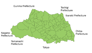 Saitama Prefecture is bordered by Tokyo
, Chiba
, Ibaraki
, Tochigi
, Gunma
, Nagano
, and Yamanashi
. It is located central-west of the Kanto region, measuring 103 km from east to west and 52 km from north to south. At 3,797 km2, it ranks as the ninth smallest prefecture. The eastern border with Chiba Prefecture
is defined by the Edo River
. The northern and north-western border lines with Gunma Prefecture
are marked by the Tone River
and the Kanagawa River and the drainage divides of the Arakawa River
and Kanagawa River. The southwestern border is defined by the drainage divides of the Arakawa River, Tama River
, and Fuefuki River. The eastern section of the southern border line, however, does overlap with any geological feature.
The topography of Saitama Prefecture is largely divided by the Hachiōji Tectonic Line, which runs through Kodama
, Ogawa
, and Hannō
, into the western mountain area and the eastern lowland area. The altitude, highest on the western side, gradually lowers eastward from mountain ranges to hills to plateaus to lowlands. The eastern lowlands and plateaus occupy 67.3 % of the area.
The eastern side, part of the Kantō Plain
, can be further divided into nine separate expanses of hills and ten plateaus. The former occupy small areas neighboring the Kantō Mount Range, including the Hiki Hills and Sayama Hills. The latter are mainly surrounded by alluvial flood plains. In the southeastern portion of the prefecture, the Ōmiya Plateau stands in a southeastward direction, sandwiched by the Furutone River to the east and the Arakawa River to the west.
The western side of the prefecture belongs to the Kantō Mountain Range with Chichibu Basin located in its center. The area to the west of the basin features high peaks such as Mount Sanpō (2,483 m) and Mount Kōbushi (2,475 m), in which the Arakawa River has its source. Most of the land is contained in Chichibu Tama Kai National Park. The area to east of the basin consists of relatively low mountains.
:
, Kan-etsu
, Shuto
, Tōhoku
, and Tokyo-Gaikan expressways
form parts of the nationwide expressway network. National highway Routes 4
, 16
, and 17
are important routes in Kantō region.
in Saitama City forms East Japan Railway Company
's northern hub station in the Greater Tokyo Area, offering transfers to and from Shinkansen
high-speed lines. The Musashino
serves as a freight bypass line as well as a passenger line.
Chichibu Railway
the northwestern,
Seibu Railway
the southwestern,
Tobu Railway
the midwestern and the eastern,
the New Shuttle and Saitama Railway the southeastern
parts of the prefecture respectively.
The Tsukuba Express line crosses the southeastern corner of the prefecture.
are the closest major civil airports. Commuter helicopter flights from Kawajima
to Narita Airport are offered.
Honda Airport
for general aviation
and the JASDF's
Iruma Air Base
, and Kumagaya Air Base offer no scheduled transport services.
(17th - 19th centuries) in the east of the prefecture are largely disused following the introduction of motorised land transport. The traces of water transports are found on the Tone River
Kumagaya
- Chiyoda, Gunma
border and
on Arakawa River
a tourist attraction in Nagatoro, Chichibu District
and
petroleum tankers from Tokyo Bay
to Wakō
.
(The United Mexican States
), affiliated on October 2, 1979Shanxi
province (The People's Republic of China), affiliated on October 27, 1982Queensland
(Commonwealth of Australia
), affiliated on October 27, 1984Ohio
(United States
), affiliated on October 22, 1990Brandenburg
(Federal Republic of Germany), affiliated on August 26, 1998
Region. This region mostly consists of a hilly and moderately mountainous area, and is situated in a rich natural environment. The region is very popular among residents of Saitama and neighboring prefectures for short trips, as it is easily accessible via the railroad network.
This festival is held by Chichibu Shrine annually on 2 December and 3 December, and has been held for more than 300 years. It is famous for the parade of six traditional wooden floats (each one weighing more than 10 tons), and is counted as one of the three big traditional float festivals in Japan (along with Gion Festival (祇園祭) in Kyoto
and Hida-Takayama Festival (飛騨高山祭) in Takayama, Gifu
).
Prefectures of Japan
The prefectures of Japan are the country's 47 subnational jurisdictions: one "metropolis" , Tokyo; one "circuit" , Hokkaidō; two urban prefectures , Osaka and Kyoto; and 43 other prefectures . In Japanese, they are commonly referred to as...
of Japan
Japan
Japan is an island nation in East Asia. Located in the Pacific Ocean, it lies to the east of the Sea of Japan, China, North Korea, South Korea and Russia, stretching from the Sea of Okhotsk in the north to the East China Sea and Taiwan in the south...
located in the Kantō region
Kanto region
The is a geographical area of Honshu, the largest island of Japan. The region includes the Greater Tokyo Area and encompasses seven prefectures: Gunma, Tochigi, Ibaraki, Saitama, Tokyo, Chiba, and Kanagawa. Within its boundaries, slightly more than 40 percent of the land area is the Kantō Plain....
of the island of Honshu
Honshu
is the largest island of Japan. The nation's main island, it is south of Hokkaido across the Tsugaru Strait, north of Shikoku across the Inland Sea, and northeast of Kyushu across the Kanmon Strait...
. The capital is the city of Saitama
Saitama, Saitama
' is the capital and the most populous city of Saitama Prefecture in Japan, situated in the south-east of the prefecture. Its area incorporates the former cities of Urawa, Ōmiya, Yono and Iwatsuki. It is a city designated by government ordinance...
.
This prefecture is part of the Greater Tokyo Area
Greater Tokyo Area
The Greater Tokyo Area is a large metropolitan area in Kantō region, Japan, consisting of most of the prefectures of Chiba, Kanagawa, Saitama, and Tokyo . In Japanese, it is referred to by various terms, including the , , and others....
, and most of Saitama's cities can be described as suburbs of Tokyo
Tokyo
, ; officially , is one of the 47 prefectures of Japan. Tokyo is the capital of Japan, the center of the Greater Tokyo Area, and the largest metropolitan area of Japan. It is the seat of the Japanese government and the Imperial Palace, and the home of the Japanese Imperial Family...
, to which a large amount of residents commute each day.
History
Saitama Prefecture was formerly part of the old Musashi ProvinceMusashi Province
was a province of Japan, which today comprises Tokyo Prefecture, most of Saitama Prefecture and part of Kanagawa Prefecture. It was sometimes called . The province encompassed Kawasaki and Yokohama...
.
In the fifth year of the Keiun
Keiun
, also known as Kyōun, was a following Taihō and preceding Wadō. The period spanned the years from May 704 through January 708. The reigning emperors were and .-Change of era:...
era (708), deposits of copper were reported to have been found in the Chichibu District
Chichibu District, Saitama
Chichibu is a district located in Saitama Prefecture, Japan.As of 2003, the district has an estimated population of 61,755 and a density of 77.58 persons per km²...
of what is now Saitama Prefecture.
The Saitama area was historically known as a fertile agricultural region which produced much of the food for the Kantō region. During the Edo period
Edo period
The , or , is a division of Japanese history which was ruled by the shoguns of the Tokugawa family, running from 1603 to 1868. The political entity of this period was the Tokugawa shogunate....
, many fudai
Fudai
was a class of daimyo who were hereditary vassals of the Tokugawa in Edo period Japan. It was primarily the fudai who filled the ranks of the Tokugawa administration.-Origins:...
daimyo
Daimyo
is a generic term referring to the powerful territorial lords in pre-modern Japan who ruled most of the country from their vast, hereditary land holdings...
ruled small domains within the Saitama area.
After World War II
World War II
World War II, or the Second World War , was a global conflict lasting from 1939 to 1945, involving most of the world's nations—including all of the great powers—eventually forming two opposing military alliances: the Allies and the Axis...
, as Tokyo expanded rapidly and modern transportation allowed longer commutes, the lack of available land in Tokyo led to the rapid development of Saitama Prefecture, whose population has nearly tripled since 1960. Most of the cities in the prefecture are closely connected to downtown Tokyo by metropolitan rail, and operate largely as residential and commercial suburbs of Tokyo.
Geography
Tokyo
, ; officially , is one of the 47 prefectures of Japan. Tokyo is the capital of Japan, the center of the Greater Tokyo Area, and the largest metropolitan area of Japan. It is the seat of the Japanese government and the Imperial Palace, and the home of the Japanese Imperial Family...
, Chiba
Chiba Prefecture
is a prefecture of Japan located in the Kantō region and the Greater Tokyo Area. Its capital is Chiba City.- History :Chiba Prefecture was established on June 15, 1873 with the merger of Kisarazu Prefecture and Inba Prefecture...
, Ibaraki
Ibaraki Prefecture
is a prefecture of Japan, located in the Kantō region on the main island of Honshu. The capital is Mito.-History:Ibaraki Prefecture was previously known as Hitachi Province...
, Tochigi
Tochigi Prefecture
is a prefecture located in the Kantō region on the island of Honshū, Japan. The capital is the city of Utsunomiya.Nikkō, whose ancient Shintō shrines and Buddhist temples UNESCO has recognized by naming them a World Heritage Site, is in this prefecture...
, Gunma
Gunma Prefecture
is a prefecture of Japan located in the northwest corner of the Kantō region on Honshu island. Its capital is Maebashi.- History :The remains of a Paleolithic man were found at Iwajuku, Gunma Prefecture, in the early 20th century and there is a public museum there.Japan was without horses until...
, Nagano
Nagano Prefecture
is a prefecture of Japan located in the Chūbu region of the island of Honshū. The capital is the city of Nagano.- History :Nagano was formerly known as the province of Shinano...
, and Yamanashi
Yamanashi Prefecture
is a prefecture of Japan located in the Chūbu region of the island of Honshū. The capital is the city of Kōfu.-Pre-history to the 14th century:People have been living in the Yamanashi area for about 30,000 years...
. It is located central-west of the Kanto region, measuring 103 km from east to west and 52 km from north to south. At 3,797 km2, it ranks as the ninth smallest prefecture. The eastern border with Chiba Prefecture
Chiba Prefecture
is a prefecture of Japan located in the Kantō region and the Greater Tokyo Area. Its capital is Chiba City.- History :Chiba Prefecture was established on June 15, 1873 with the merger of Kisarazu Prefecture and Inba Prefecture...
is defined by the Edo River
Edo River
thumb|The Edo River in [[Nagareyama, Chiba]] PrefectureThe is a river in the Kantō region of Japan. It splits from the Tone River at the northernmost tip of Narita City, crosses through Nagareyama and Matsudo, and empties into Tokyo Bay at Ichikawa. The Edo forms the borders between Tokyo, Chiba,...
. The northern and north-western border lines with Gunma Prefecture
Gunma Prefecture
is a prefecture of Japan located in the northwest corner of the Kantō region on Honshu island. Its capital is Maebashi.- History :The remains of a Paleolithic man were found at Iwajuku, Gunma Prefecture, in the early 20th century and there is a public museum there.Japan was without horses until...
are marked by the Tone River
Tone River
The is a river in the Kantō region of Japan. It is in length and has a drainage area of...
and the Kanagawa River and the drainage divides of the Arakawa River
Arakawa River
The is one of the principal rivers flowing through Tokyo, the capital city of Japan. The point of origin is on Mount Kobushi in Saitama Prefecture, and the Arakawa River empties into Tokyo Bay, spanning 173 kilometers. The drainage basin covers 2,940 square kilometers...
and Kanagawa River. The southwestern border is defined by the drainage divides of the Arakawa River, Tama River
Tama River
The is a major river in Yamanashi, Kanagawa and Tokyo Prefectures on Honshū, Japan. It is officially classified as a Class 1 river by the Japanese government....
, and Fuefuki River. The eastern section of the southern border line, however, does overlap with any geological feature.
The topography of Saitama Prefecture is largely divided by the Hachiōji Tectonic Line, which runs through Kodama
Kodama, Saitama
Kodama was a town located in Kodama District, Saitama, Japan.On January 10, 2006 Kodama was merged into the city of Honjō and no longer exists as an independent municipality....
, Ogawa
Ogawa, Saitama
is a town located in Hiki District, Saitama, Japan.As of 2003, the town has an estimated population of 36,147 and a density of 597.97 persons per km². The total area is 60.45 km².The town was traditionally famous for papermaking.-External links:*...
, and Hannō
Hanno
Hanno may refer to:* Hanno, Saitama, Honshū, Japan* Hanno , a lunar crater* Hanno , the pet white elephant of Pope Leo XPeople named Hanno:*Several ancient Carthaginians, including:...
, into the western mountain area and the eastern lowland area. The altitude, highest on the western side, gradually lowers eastward from mountain ranges to hills to plateaus to lowlands. The eastern lowlands and plateaus occupy 67.3 % of the area.
The eastern side, part of the Kantō Plain
Kanto Plain
The ' is the largest plain in Japan located in the Kanto Region of central Honshū. The total area 17,000 sq km covers more than half of the Region extending over Tokyo, Saitama Prefecture, Kanagawa Prefecture, Chiba Prefecture, Gunma Prefecture, and Tochigi Prefecture.The northern limit borders on...
, can be further divided into nine separate expanses of hills and ten plateaus. The former occupy small areas neighboring the Kantō Mount Range, including the Hiki Hills and Sayama Hills. The latter are mainly surrounded by alluvial flood plains. In the southeastern portion of the prefecture, the Ōmiya Plateau stands in a southeastward direction, sandwiched by the Furutone River to the east and the Arakawa River to the west.
The western side of the prefecture belongs to the Kantō Mountain Range with Chichibu Basin located in its center. The area to the west of the basin features high peaks such as Mount Sanpō (2,483 m) and Mount Kōbushi (2,475 m), in which the Arakawa River has its source. Most of the land is contained in Chichibu Tama Kai National Park. The area to east of the basin consists of relatively low mountains.
Cities
|
Iruma, Saitama is a city in Saitama Prefecture, Japan, near Tokyo.As of 2010, the city has an estimated population of 149,269 and a population density of 3,340 persons per km². The total area is 44.74 km². The city consists of 6 areas, Toyooka, Kaneko, Higashikaneko, Fujisawa, Miyadera-Nihongi, and... Kasukabe, Saitama is a city in eastern Saitama, Japan, approximately north of Tokyo. It was formerly located in Kitakatsushika and Minamisaitama districts. Kasukabe once prospered as part of the Nikkō Kaidō highway, an important trade route that linked Edo with Nikkō.-Overview:... Kawagoe, Saitama is a city located in Saitama Prefecture, Japan, and is about a 30-minute train ride from Ikebukuro in Tokyo.As of July 1, 2011, the city has an estimated population of 343,926... Kawaguchi, Saitama is a city located in Saitama Prefecture, Japan. The city was founded on April 1, 1933.As of January 1, 2011, the city has an estimated population of 517,171, the second largest in Saitama Prefecture after Saitama, and a population density of 9,276.61 persons per km². The total area is 55.75 km²... Kazo, Saitama is a city located in Saitama, Japan.As of April 1, 2011, the city has an estimated population of 117,339, with a household number of 42,778, and a density of 879.14 persons per km²... Kitamoto, Saitama is a city located in Saitama Prefecture, Japan.As of June 1, 2011, the city has an estimated population of 70,237 with 27,714 households and a population density of 3,527.42 persons per km²... Koshigaya, Saitama is a city located in Saitama Prefecture, Japan.As of 2010, the city has an estimated population of 325,074 and a population density of 5,390 persons per km². The total area is 60.31 km².... Kuki, Saitama is a city located in Saitama, Japan.As of May 1, 2011, the city has an estimated population of 156,613, with a household number of 61,071, and the density of 1,900.64 persons per km²... Kumagaya, Saitama is a city in Saitama Prefecture, Japan.As of 2010, the city has an estimated population of 203,089 . The total area is 159.88 km². The city is one of the biggest in northern Saitama Prefecture. It is the administrative, business and commercial centre in northern Saitama Prefecture. Eight... Niiza, Saitama is a city located in Saitama Prefecture, Japan, and is essentially a suburb of the Tokyo conurbation. Niiza is located at the southernmost part of Saitama. As of 2010, the city has an estimated population of 159,741 and a population density of 7,010 persons per km²... Okegawa, Saitama is a city located in Saitama, Japan. It was founded on November 3, 1970, and as of 2003, the city has an estimated population of 73,881 and the density of 2,924.82 persons per km²... |
Saitama, Saitama ' is the capital and the most populous city of Saitama Prefecture in Japan, situated in the south-east of the prefecture. Its area incorporates the former cities of Urawa, Ōmiya, Yono and Iwatsuki. It is a city designated by government ordinance... (capital) Sakado, Saitama is a city located in Saitama Prefecture, Japan.As of 1 July 2009, the city has an estimated population of 100,942 . The total area is 40.97 km².The town of Sakado was upgraded to city status on 1 September 1976.-Adjoining cities and towns:... Satte, Saitama is a city located in Saitama, Japan.As of April 1, 2011, the city has an estimated population of 54,444, with a household number of 21,449 and the density of 1,603.658 persons per km². The total area is 33.95 km².The city was founded on October 1, 1986.... Sayama, Saitama , formerly known as Irumagawa, is a city located in Saitama, Japan. Sayama translates as "sitting on a mountain”. The city was founded on July 1, 1954.... Shiki, Saitama is a city located in Saitama Prefecture, Japan.The city was founded on 26 October 1970. As of 1 April 2008, it has an estimated population of 69,549. The total area is 9.06 km².-Geography and transportation:... Soka, Saitama is a city located in Saitama, Japan.As of October 1, 2010, the city has an estimated population of 243,111 and the density of 8,866.19 persons per km²... Toda, Saitama is a city located in Saitama, Japan. The city is located beside the Arakawa river which separates it from Tokyo. The Sasame river also flows through the city before joining the Arakawa.-History:... Tokorozawa, Saitama is a city in Saitama, Japan. It is located in the central part of the Musashino plain, about 30 km west of downtown Tokyo. Tokorozawa can be considered part of the greater Tokyo area; its proximity to the latter and lower housing costs make it a popular bedroom community.-Location:Tokorozawa... Tsurugashima, Saitama is a city located in Saitama Prefecture, Japan.As of May 1, 2008, the city has an estimated population of 69,919 . The total area is 17.73 km².... Wako, Saitama is a city located in the southern part of Saitama, Japan, bordering on Tokyo.As of 1 May 2008, the city has an estimated population of 76,221. The total area is 11.04 km².... Warabi, Saitama is a city located in Saitama, Japan. Warabi is the name of a bracken. The city was founded on April 1, 1959.As of 2003, the city has an estimated population of 71,034 and a density of 13,928.24 persons per km². The total area is 5.10 km²... Yashio, Saitama is a city in Saitama Prefecture, Japan.As of 2008, the city has an estimated population of 81,148 and a population density of 4,500.7 persons per km²... Yoshikawa, Saitama is a city located in Saitama, Japan.As of May 1, 2011, the city had an estimated population of 66,773, with 25,194 households and a density of 2,111.73 persons per km². The total area is 31.62 km².The city incorporated as a city on April 1, 1996... |
Towns and villages
Towns and villages in each districtDistricts of Japan
The was most recently used as an administrative unit in Japan between 1878 and 1921 and is roughly equivalent to the county of the United States, ranking at the level below prefecture and above city, town or village. As of 2008, cities belong directly to prefectures and are independent from...
:
|
Miyoshi, Saitama is a town located in Iruma District, Saitama, Japan.As of 2003, the town has an estimated population of 36,587 and a density of 2,391.31 persons per km². The total area is 15.30 km².-External links:*... Moroyama, Saitama is a town located in Iruma District, Saitama, Japan.As of July 2008, the town has an estimated population of 39,298 and a density of . The total area is .-History:... Ogose, Saitama is a town in the Iruma District of Saitama Prefecture. It is noted for ume blossoms in early spring.-External links:*...
Ina, Saitama is a town located in Kitaadachi District, Saitama, Japan.As of 2003, the town has an estimated population of 35,355 and a density of 2,388.85 persons per km². The total area is 14.80 km².-External links:*...
Matsubushi, Saitama is a town located in Kitakatsushika District, Saitama, Japan.As of 2003, the town has an estimated population of 30,885 and a density of 1,904.13 persons per km². The total area is 16.22 km².... Sugito, Saitama is a town located in Kitakatsushika District, Saitama, Japan.As of 2003, the town has an estimated population of 46,856 and a density of 1,561.87 persons per km². The total area is 30.00 km².Sugito town is 45 minutes north of Tokyo by train... |
Kamikawa, Saitama is a town located in Kodama District, Saitama, Japan. Situated on the banks of the Kanna River. As of 2003, the town has an estimated population of 13,704 and a density of 591.45 persons per km². The total area is 23.17 km².... Kamisato, Saitama is a town located in Kodama District, Saitama, Japan.As of 2003, the town has an estimated population of 30,913 and a density of 1,058.30 persons per km². The total area is 29.21 km². Kamisato has one train station called Jimbohara Station, which is a part of JR's Takasaki line.-External links:* *... Misato, Saitama (town) is a town located in Kodama District, Saitama, Japan.In 2005, the town had an estimated population of 12,077. The total area is 33.48 km2.-External links:*...
Miyashiro, Saitama is a town located in Minamisaitama district, Saitama, Japan.As of 2005, the town has an estimated population of 34,620. The total area is 15.95 km². The average age of Miyashiro residents is 42.... Shiraoka, Saitama is a town located in Minami Saitama District, Saitama, Japan.As of 2003, the town has an estimated population of 47,777 and a density of 1,920.30 persons per km². The total area is 24.88 km².-External links:*...
Yorii, Saitama is a town located in Ōsato District, Saitama, Japan.As of 2003, the town has an estimated population of 37,548 and a density of 585.13 persons per km². The total area is 64.17 km².Hachigata Castle is located in Yorii.-External links:*... |
Transportation
Radial transportation to and from Tokyo dominates transportation in the prefecture. Circular routes were constructed as bypasses to avoid congestion in central Tokyo.Roads
The JōbanJoban Expressway
The , abbreviated , is a national expressway in Japan. It is owned and operated by East Nippon Expressway Company.-Naming:Jōban is a kanji acronym consisting of two characters...
, Kan-etsu
Kan-Etsu Expressway
The is a national expressway in Japan. It is owned and managed by East Nippon Expressway Company.-Naming: is the kanji acronym of and the old comprising modern-day Niigata Prefecture....
, Shuto
Shuto Expressway
is a network of toll expressways in the Greater Tokyo Area of Japan. It is operated and maintained by the .Most routes consist of elevated roadway above other roads or over water, and have many sharp curves which require caution to drive safely...
, Tōhoku
Tohoku Expressway
The is a national expressway in Japan. It is owned by Japan Expressway Holding and Debt Repayment Agency and operated by East Nippon Expressway Company.-Naming:Tōhoku refers to the Tōhoku region, the northernmost region on the island of Honshū....
, and Tokyo-Gaikan expressways
Expressways of Japan
The expressways of Japan make up a large network of freeway-standard toll roads.- History :Following World War II, Japan's economic revival led to a massive increase in personal automobile use...
form parts of the nationwide expressway network. National highway Routes 4
Route 4 (Japan)
National Route 4 is a major highway in eastern Honshū, Japan. The longest of the ordinary highways in Japan, it originates in Chūō, Tokyo and stretches north for 743.6 km to the city of Aomori in Aomori Prefecture. From Saitama Prefecture to Iwate Prefecture, it parallels the Tōhoku...
, 16
Route 16 (Japan)
National Route 16 is a national highway in Japan. A beltway around Tokyo, it links the major prefectural capital cities of Yokohama , Saitama , and Chiba as well as Hachiōji . It also serves Yokosuka and Sagamihara , Kasukabe , and Kisarazu...
, and 17
Route 17 (Japan)
National Route 17 is a highway on the island of Honshū in Japan. It originates at Nihonbashi in Chūō, Tokyo and terminates in the city of Niigata , where it meets Routes 7, 8, 49, 113 and 116)....
are important routes in Kantō region.
Railways
Ōmiya StationOmiya Station (Saitama)
is a railway station in Ōmiya-ku, Saitama, Japan. It is a major interchange station for the East Japan Railway Company .-JR East:* Tōhoku Shinkansen* Akita Shinkansen* Yamagata Shinkansen* Jōetsu Shinkansen* Nagano Shinkansen...
in Saitama City forms East Japan Railway Company
East Japan Railway Company
is the largest passenger railway company in the world and one of the seven Japan Railways Group companies. The company name is officially abbreviated as JR East in English, and as in Japanese. The company's headquarters are in Yoyogi, Shibuya, Tokyo....
's northern hub station in the Greater Tokyo Area, offering transfers to and from Shinkansen
Shinkansen
The , also known as THE BULLET TRAIN, is a network of high-speed railway lines in Japan operated by four Japan Railways Group companies. Starting with the Tōkaidō Shinkansen in 1964, the network has expanded to currently consist of of lines with maximum speeds of , of Mini-shinkansen with a...
high-speed lines. The Musashino
Musashino Line
The is a railway line operated by the East Japan Railway Company . It links Tsurumi Station in Yokohama with Nishi-Funabashi Station in Chiba Prefecture, forming a 100.6 km unclosed loop around central Tokyo...
serves as a freight bypass line as well as a passenger line.
Chichibu Railway
Chichibu Railway
is a small-sector private railway company operating two railway lines in northern Saitama Prefecture, Japan. In addition to its railway operations, the company deals in the real estate and tourism industries. It also manages the Mitsumine Ropeway...
the northwestern,
Seibu Railway
Seibu Railway
is a conglomerate based in Tokorozawa, Japan, with principal business areas in railways, tourism and real estate. Seibu Railway's operations are concentrated in northwest Tokyo and Saitama Prefecture; the name "Seibu" is an abbreviation of "west Musashi," referring to the historic name for this area...
the southwestern,
Tobu Railway
Tobu Railway
is a Japanese commuter railway company in the Greater Tokyo Area as well as an intercity and regional operator in the Kantō region. It operates in Tokyo, Saitama, Chiba, Tochigi, and Gunma Prefectures...
the midwestern and the eastern,
the New Shuttle and Saitama Railway the southeastern
parts of the prefecture respectively.
The Tsukuba Express line crosses the southeastern corner of the prefecture.
- East Japan Railway CompanyEast Japan Railway Companyis the largest passenger railway company in the world and one of the seven Japan Railways Group companies. The company name is officially abbreviated as JR East in English, and as in Japanese. The company's headquarters are in Yoyogi, Shibuya, Tokyo....
- Tōhoku ShinkansenTohoku ShinkansenThe is a Japanese high-speed Shinkansen rail line, connecting Tokyo with Aomori in Aomori Prefecture for a total length of 674 km, Japan's longest Shinkansen line. It runs through the more sparsely populated Tōhoku region of Japan's main island Honshu. It has two spur lines, Yamagata...
- Jōetsu ShinkansenJoetsu ShinkansenThe is a high-speed railway line connecting Tokyo and Niigata, Japan, via the Tōhoku Shinkansen, operated by the East Japan Railway Company .-History:The program was initiated in 1971 by Niigata-born prime minister Tanaka Kakuei...
- Utsunomiya LineUtsunomiya LineThe is the name given to a 159.9 kilometre section of the Tōhoku Main Line between Ueno Station in Tokyo and Kuroiso Station in Nasushiobara, Tochigi, Japan...
(Tōhoku Main Line) - Takasaki LineTakasaki LineThe is a Japanese railway line which runs between Ōmiya Station in Saitama, Saitama Prefecture and Takasaki Station in Takasaki, Gunma Prefecture. It is owned and operated by the East Japan Railway Company ....
- Shōnan-Shinjuku LineShonan-Shinjuku LineThe is a passenger railway service in Japan which commenced in December 2001. The line has no dedicated track as services run through shared sections along the Ryōmō Line, Takasaki Line, Utsunomiya Line, Yamanote Freight Line, Yokosuka Line, and Tōkaidō Main Line...
- Keihin-Tōhoku LineKeihin-Tohoku LineThe , is a railway line in Japan which connects the cities of Saitama, Kawaguchi, Tokyo, Kawasaki, and Yokohama. It is part of the East Japan Railway Company network. The line's name is derived from the characters for , and the...
- Saikyō LineSaikyo LineThe is a railway line between Ōsaki Station in Shinagawa, Tokyo, and Ōmiya Station in Saitama Prefecture, Japan. It is a part of the East Japan Railway Company network...
- Musashino LineMusashino LineThe is a railway line operated by the East Japan Railway Company . It links Tsurumi Station in Yokohama with Nishi-Funabashi Station in Chiba Prefecture, forming a 100.6 km unclosed loop around central Tokyo...
- Kawagoe LineKawagoe LineThe is a railway line operated by East Japan Railway Company , which connects the cities of Saitama, Kawagoe, and Hidaka in Saitama Prefecture, Japan...
- Hachikō LineHachiko LineThe is a 92.0 km regional railway line owned and operated by East Japan Railway Company . It is located within Tokyo, Saitama, and Gunma Prefectures in Japan. Its endpoints are Hachiōji Station in Hachiōji, Tokyo and Kuragano Station in Takasaki, Gunma Prefecture.-Services:Komagawa Station in...
- Tōhoku Shinkansen
- TobuTobu Railwayis a Japanese commuter railway company in the Greater Tokyo Area as well as an intercity and regional operator in the Kantō region. It operates in Tokyo, Saitama, Chiba, Tochigi, and Gunma Prefectures...
- Isesaki Line
- Tojo Line
- Nikko Line
- Noda Line
- SeibuSeibu Railwayis a conglomerate based in Tokorozawa, Japan, with principal business areas in railways, tourism and real estate. Seibu Railway's operations are concentrated in northwest Tokyo and Saitama Prefecture; the name "Seibu" is an abbreviation of "west Musashi," referring to the historic name for this area...
- Ikebukuro LineSeibu Ikebukuro LineThe is a commuter railway line of the Japanese private railway operator Seibu Railway. It originates at Ikebukuro Station, a large railway junction in north-western Tokyo, extending to northwest suburbs as far as Tokorozawa, Saitama, and nominally terminates at Agano Station.The Seibu Chichibu...
- Shinjuku Line
- Chichibu LineSeibu Chichibu LineThe is a railway line in Saitama, Japan. It is an extension of the Seibu Ikebukuro Line, and connects Agano Station and Seibu-Chichibu Station. It is managed by Seibu Railway.-History:...
- Sayama LineSeibu Sayama Lineis a commuter railway line of the Seibu Railway, a major private railroad in Japan. This line connects the Nishi-Tokorozawa Station and Seibu-Kyūjō-mae Station in Tokorozawa, Saitama.-Stations:* Nishi-Tokorozawa* Shimo-Yamaguchi* Seibu-Kyūjō-mae...
- Ikebukuro Line
- Tokyo MetroTokyo Metrois one of two rapid transit systems making up the Tokyo subway system, the other being Toei. It is the most used subway system in the world in terms of annual passenger rides.-Organization:...
- Fukutoshin Line
- Yurakucho LineTokyo Metro Yurakucho LineThe is a subway line owned and operated by Tokyo Metro. The line connects Wakōshi Station in Wakō, Saitama and Shin-Kiba Station in Kōtō, Tokyo. On maps, diagrams and signboards, the line is shown using the color "gold" , and its stations are given numbers using the letter Y.The proper name as...
- Tsukuba Express
- Saitama Rapid Railway LineSaitama Rapid Railway LineThe is the continuation of the Namboku Line, starting at Akabane-Iwabuchi station in Tokyo and ending at Urawa Misono Station in Saitama. It was completed on March 28, 2001....
- Chichibu RailwayChichibu Railwayis a small-sector private railway company operating two railway lines in northern Saitama Prefecture, Japan. In addition to its railway operations, the company deals in the real estate and tourism industries. It also manages the Mitsumine Ropeway...
- Chichibu MainlineChichibu MainlineThe is a railway line in Japan, owned by Chichibu Railway, which links Hanyū and Mitsumineguchi, both in Saitama Prefecture.Locals living around the line call it the Chichibu sen, or Chichibu line...
- Mikajiri Line
- Chichibu Mainline
People movers
- Saitama New Urban Transit (New Shuttle}
- Seibu Yamaguchi LineSeibu Yamaguchi LineThe of Seibu Railway is a manually operated people mover that runs between in Higashimurayama, Tokyo and Seibu-Kyūjōmae Station in Tokorozawa, Saitama in Japan. The line has an official nickname Leo Liner, after 'Leo', the hero of Kimba the White Lion, who is also the mascot of Seibu Lions...
(Leo Liner}
Airports
Haneda Airport and Narita International AirportNarita International Airport
is an international airport serving the Greater Tokyo Area of Japan. It is located east of Tokyo Station and east-southeast of Narita Station in the city of Narita, and the adjacent town of Shibayama....
are the closest major civil airports. Commuter helicopter flights from Kawajima
Kawajima, Saitama
is a town located in Hiki District, Saitama, Japan.As of 2003, the town has an estimated population of 23,028 and a density of 551.97 persons per km². The total area is 41.72 km².-External links:*...
to Narita Airport are offered.
Honda Airport
Honda Airport
is a private airfield in the town of Kawajima, Hiki District, and the city of Okegawa, both in Saitama Prefecture, Japan. Another name for it is Okegawa Airfield. The operator is Honda Airways, a subsidiary of Honda Motor Co. Ltd.-Data:...
for general aviation
General aviation
General aviation is one of the two categories of civil aviation. It refers to all flights other than military and scheduled airline and regular cargo flights, both private and commercial. General aviation flights range from gliders and powered parachutes to large, non-scheduled cargo jet flights...
and the JASDF's
Japan Air Self-Defense Force
The , or JASDF, is the aviation branch of the Japan Self-Defense Forces responsible for the defense of Japanese airspace and other aerospace operations. The JASDF carries out combat air patrols around Japan, while also maintaining an extensive network of ground and air early warning radar systems...
Iruma Air Base
Iruma Air Base
is a Japan Air Self-Defense Force base located in the city of Sayama, Saitama Prefecture, north of western Tokyo, Japan.Iruma Air Base is currently home to the Air Defense Command Headquarters Flight Group...
, and Kumagaya Air Base offer no scheduled transport services.
Waterways
Rivers and canals including those developed in the Edo periodEdo period
The , or , is a division of Japanese history which was ruled by the shoguns of the Tokugawa family, running from 1603 to 1868. The political entity of this period was the Tokugawa shogunate....
(17th - 19th centuries) in the east of the prefecture are largely disused following the introduction of motorised land transport. The traces of water transports are found on the Tone River
Tone River
The is a river in the Kantō region of Japan. It is in length and has a drainage area of...
Kumagaya
Kumagaya, Saitama
is a city in Saitama Prefecture, Japan.As of 2010, the city has an estimated population of 203,089 . The total area is 159.88 km². The city is one of the biggest in northern Saitama Prefecture. It is the administrative, business and commercial centre in northern Saitama Prefecture. Eight...
- Chiyoda, Gunma
Chiyoda, Gunma
is a town located in Ōra District, Gunma, Japan.As of 2003, the town has an estimated population of 11,640 and a density of 534.93 persons per km²...
border and
on Arakawa River
Arakawa River
The is one of the principal rivers flowing through Tokyo, the capital city of Japan. The point of origin is on Mount Kobushi in Saitama Prefecture, and the Arakawa River empties into Tokyo Bay, spanning 173 kilometers. The drainage basin covers 2,940 square kilometers...
a tourist attraction in Nagatoro, Chichibu District
Nagatoro, Saitama
is a town located in Chichibu District, Saitama, Japan.As of 2003, the town has an estimated population of 8,329 and a density of 273.98 persons per km². The total area is 30.40 km²....
and
petroleum tankers from Tokyo Bay
Tokyo Bay
is a bay in the southern Kantō region of Japan. Its old name was .-Geography:Tokyo Bay is surrounded by the Bōsō Peninsula to the east and the Miura Peninsula to the west. In a narrow sense, Tokyo Bay is the area north of the straight line formed by the on the Miura Peninsula on one end and on...
to Wakō
Wako, Saitama
is a city located in the southern part of Saitama, Japan, bordering on Tokyo.As of 1 May 2008, the city has an estimated population of 76,221. The total area is 11.04 km²....
.
Sister relationships
Saitama Prefecture has a number of sister city relationships with states and a province as listed below (in chronological order).Mexico StateMexico (state)
México , officially: Estado Libre y Soberano de México is one of the 31 states which, with the Federal District, comprise the 32 Federal Entities of the United Mexican States. It is divided in 125 municipalities and its capital city is Toluca de Lerdo....
(The United Mexican States
Mexico
The United Mexican States , commonly known as Mexico , is a federal constitutional republic in North America. It is bordered on the north by the United States; on the south and west by the Pacific Ocean; on the southeast by Guatemala, Belize, and the Caribbean Sea; and on the east by the Gulf of...
), affiliated on October 2, 1979Shanxi
Shanxi
' is a province in Northern China. Its one-character abbreviation is "晋" , after the state of Jin that existed here during the Spring and Autumn Period....
province (The People's Republic of China), affiliated on October 27, 1982Queensland
Queensland
Queensland is a state of Australia, occupying the north-eastern section of the mainland continent. It is bordered by the Northern Territory, South Australia and New South Wales to the west, south-west and south respectively. To the east, Queensland is bordered by the Coral Sea and Pacific Ocean...
(Commonwealth of Australia
Australia
Australia , officially the Commonwealth of Australia, is a country in the Southern Hemisphere comprising the mainland of the Australian continent, the island of Tasmania, and numerous smaller islands in the Indian and Pacific Oceans. It is the world's sixth-largest country by total area...
), affiliated on October 27, 1984Ohio
Ohio
Ohio is a Midwestern state in the United States. The 34th largest state by area in the U.S.,it is the 7th‑most populous with over 11.5 million residents, containing several major American cities and seven metropolitan areas with populations of 500,000 or more.The state's capital is Columbus...
(United States
United States
The United States of America is a federal constitutional republic comprising fifty states and a federal district...
), affiliated on October 22, 1990Brandenburg
Brandenburg
Brandenburg is one of the sixteen federal-states of Germany. It lies in the east of the country and is one of the new federal states that were re-created in 1990 upon the reunification of the former West Germany and East Germany. The capital is Potsdam...
(Federal Republic of Germany), affiliated on August 26, 1998
Football (soccer)
- Urawa Red DiamondsUrawa Red Diamondsare a professional association football club playing in Japan's football league, J. League Division 1. One of Japan and Asia's best supported teams, the club has been able to boast the highest average crowds for thirteen of the J-League's twenty season history...
(SaitamaSaitama, Saitama' is the capital and the most populous city of Saitama Prefecture in Japan, situated in the south-east of the prefecture. Its area incorporates the former cities of Urawa, Ōmiya, Yono and Iwatsuki. It is a city designated by government ordinance...
) - Omiya ArdijaOmiya Ardijais a professional football club which play in the J. League Division 1, and are based in Ōmiya-ku in Saitama, Japan. Its "hometown" as designated by the league is the whole of Saitama city, which is shared with neighbours Urawa Red Diamonds...
(SaitamaSaitama, Saitama' is the capital and the most populous city of Saitama Prefecture in Japan, situated in the south-east of the prefecture. Its area incorporates the former cities of Urawa, Ōmiya, Yono and Iwatsuki. It is a city designated by government ordinance...
)
Volleyball
- Takefuji BambooTakefuji BambooTakefuji Bamboo is a women's Volleyball team based in Kitakatsushika District Sugito Town, Saitama, Japan. It plays in V.Premier League. The club was founded in 2001.The team logo is based on Kaguya-hime, principal character in Japanese mythology The Tale of the Bamboo Cutter.The owner of the team...
(Kitakatsushika DistrictKitakatsushika District, Saitamais a district located in Saitama Prefecture, Japan.As of July 1, 2011, the district has an estimated population of 77,583 and a population density of 1,680 persons per km²...
)
Tourism
Most of the popular tourist sites in Saitama are located in the northwestern part of the prefecture, which is known as the ChichibuChichibu, Saitama
is a city in Saitama, Japan. As of April 1, 2011, the city has an estimated population of 68,701, with a household number of 26,230. The total area is 577.69 km²....
Region. This region mostly consists of a hilly and moderately mountainous area, and is situated in a rich natural environment. The region is very popular among residents of Saitama and neighboring prefectures for short trips, as it is easily accessible via the railroad network.
Visitor attractions
- Chichibu 34 Kannon Sanctuary
- Chichibu ShrineChichibu ShrineThe is an ancient Shinto shrine in the city of Chichibu, Saitama Prefecture, Japan. The shrine is devoted to Yagokoro-omoikane-no-mikoto, Chichibuhiko-no-mikoto, and Ame-no-minaka-nushi-no-kami, and also enshrines Prince Chichibu....
- Gyoda City Provincial Museum
- Iwatsuki Doll Museum
- Railway Museum (Saitama)
- Kitain Temple
- Omiya Bonsai VillageOmiya Bonsai Villageis the nickname for the bonsai nursery precinct in , Kita-ku, Saitama, Japan.Bonsai Village is located near Ōmiya-kōen Station on the Tobu Noda Line...
- Saitama Super ArenaSaitama Super Arenais a multi-purpose indoor arena located in Chūō-ku, Saitama City, Saitama, Japan. Its spectator capacity is 37,000 at maximum settings.This main arena capacity is between 19,000-22,500 when events such as basketball, volleyball, tennis, ice hockey, gymnastics, boxing, mixed martial arts and...
- Sakitama Fudoki Hill
Events
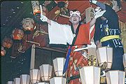
- Chichibu Night Festival (秩父夜祭)
This festival is held by Chichibu Shrine annually on 2 December and 3 December, and has been held for more than 300 years. It is famous for the parade of six traditional wooden floats (each one weighing more than 10 tons), and is counted as one of the three big traditional float festivals in Japan (along with Gion Festival (祇園祭) in Kyoto
Kyoto
is a city in the central part of the island of Honshū, Japan. It has a population close to 1.5 million. Formerly the imperial capital of Japan, it is now the capital of Kyoto Prefecture, as well as a major part of the Osaka-Kobe-Kyoto metropolitan area.-History:...
and Hida-Takayama Festival (飛騨高山祭) in Takayama, Gifu
Takayama, Gifu
is a city located in Gifu, Japan. As of July, 2011 the city has an estimated population of 92,369. The total area is .Takayama was settled as far back as the Jōmon period. Takayama is best known for its inhabitants' expertise in carpentry. It is believed carpenters from Takayama worked on the...
).
Others
- Koedo Kawagoe Spring Festival
- Kawagoe Hikawa Festival on October
- Kumagaya Uchiwa Festival on July 19 to 22