
Greater Tokyo Area
Encyclopedia
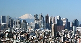
The Greater Tokyo Area is a large metropolitan area
in Kantō region
, Japan
, consisting of most of the prefectures
of Chiba
, Kanagawa
, Saitama
, and Tokyo
(at the center). In Japanese
, it is referred to by various terms, including the , , and others.
A 2007 UN estimate puts the population at 35,676,000, making it the world's most populous metropolitan area by far. It covers an area of approximately 13,500 km² (5,200 mi²), giving it a population density of 2,642 person/km² - which is somewhat more than twice the population density of Bangladesh
. It is the second largest single metropolitan area in the world in terms of built-up or urban function landmass at 7,800 km² (3,000 mi²). Only the New York metropolitan area
, at 17,405 km², is larger.
The area has the largest metropolitan economy in the world, with a total GDP (nominal) of approximately US$1.9 trillion (165 trillion Yen) in 2008. According to research published by PricewaterhouseCoopers
, the agglomeration of Tokyo had a total GDP of US$1.479 trillion in 2008 (at purchasing power parity
), ranking again as the largest urban agglomeration GDP in the world.
of New York, at 30,671 km². and 21.9 million people.
. It is not administered as a single city.
, which was dismantled during World War II
. Its subdivisions have been reclassified as . The twenty three special wards currently have the legal status of cities, with individual mayors and city councils, and call themselves "cities" in English. However, when listing Japan's largest cities, Tokyo's twenty three wards are often counted as one city. See: Special wards of Tokyo
, known as the Tama Area (Tama-chiiki 多摩地域) comprises a number of municipalities, including these suburban cities:
 The core cities of the Greater Tokyo Area outside Tokyo Metropolis are:
The other cities in Chiba, Kanagawa and Saitama Prefectures are:
source: stat.go.jp census 2005
, Tochigi
, Gunma
, Yamanashi
, and Shizuoka
Prefectures are included:
-Mishima
(approx. 450,000) to the southwest, Maebashi
-Takasaki
-Ōta
-Ashikaga
(approx. 1,500,000 people) on the northwest, and Greater Utsunomiya
(:ja:宇都宮都市圏) approx. 1,000,000) to the north. If they are included, Greater Tokyo's population would be around 39 million.
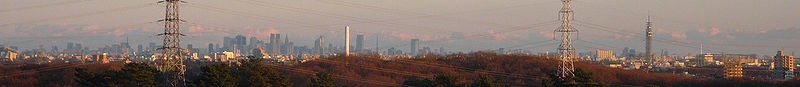
 At the centre of the main urban area (approximately the first 10 km from Tokyo Station
) are the 23 special wards, formerly treated as a single city but now governed as separate municipalities, and containing many major commercial centres such as Shinjuku, Shibuya
, Ikebukuro
and Ginza
. Around the 23 special wards are a multitude of suburban cities which merge seamlessly into each other to form a continuous built up area, circumnavigated by the heavily-travelled Route 16
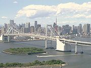
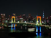
which forms a (broken) loop about 40 km from central Tokyo. Situated along the loop are the major cities of Yokohama (to the south of Tokyo), Hachiōji (to the west), Ōmiya (now part of Saitama City, to the north), and Chiba (to the east). Within the Route 16 loop, the coastline of Tokyo Bay
is heavily industrialised, with the Keihin Industrial Area stretching from Tokyo down to Yokohama, and the Keiyō Industrial Area from Tokyo eastwards to Chiba. Along the periphery of the main urban area are numerous new suburban housing developments such as the Tama New Town
. The landscape is relatively flat compared to most of Japan, most of it comprising low hills.
Outside the Route 16 loop the landscape becomes more rural. To the southwest is an area known as Shōnan
comprising various cities and towns along the coast of Sagami Bay
, with their long beaches comprising black volcanic sand, and to the west the area is mountainous.
Many rivers run through the area, the major ones being Arakawa
and Tama River
.
Source
 The agglomeration of Tokyo is the world's largest economy, with the largest gross metropolitan product at purchasing power parity (PPP)
in the world in 2005 according to a study by PricewaterhouseCoopers
.
, commonly known as Haneda Airport (chiefly domestic) and Narita International Airport
(chiefly international). Minor facilities include the Chōfu
and Honda Airport
. Tokyo Heliport
serves helicopter traffic, including police, fire, and news. Various military facilities handle air traffic: Naval Air Facility Atsugi
(United States Navy
and Japan Maritime Self-Defense Force
), Hyakuri Airfield
(Japan Air Self-Defense Force
), Yokota Air Base
(United States Air Force
), and Camp Zama
(United States Army
). Hyakuri is being developed for civil aviation with plans for service to begin in March 2010; it will be called Ibaraki Airport.
, commuter rails, subway
s, monorail
s, private lines
, tram
s and others. There are around 136 individual rail lines in the Greater Tokyo Area, and between 1,000 to 1,200 railway stations depending on one's definition of the area, most designed for heavy use, usually long enough to accommodate 10-car trains. Major stations are designed to accommodate hundreds of thousands of passengers at any given time, with miles of connecting tunnels linking vast department stores and corporate offices. Tokyo Station
has underground connections that stretch well over 4 kilometers, and Shinjuku Station
has well over 200 exits. Greater Tokyo's Railway Network is easily considered the world's largest in terms of both daily passenger throughput with a daily trips of over 40 million (20 million different passengers) as well as physical extent with approximately 2,578 kilometers of track. Some 57 percent of all Greater Tokyo residents used rail as their primary means of transport in 2001.
JR East
and many other carriers crisscross the region with a network of rail lines. (See this map showing the Suica
/PASMO
accepting area that roughly corresponds with Greater Tokyo). The most important carriers include Keihin Kyūkō Electric Railway
(Keikyū), Keisei Electric Railway
, Keiō Electric Railway, Odakyū Electric Railway
, Seibu Railway
, Tōbu Railway
, and Tōkyū Corporation. In addition to Tokyo's two subway systems — Tokyo Metro
and Tokyo Metropolitan Bureau of Transportation
(Toei and Toden
lines), Yokohama operates three lines
. The Tokyo Monorail
provides service to Haneda Airport and other destinations.
system connects other national expressways
in the capital region.
Tokyo and Yokohama are major commercial seaports, and both the Maritime Self-Defense Force and United States Navy
maintain naval bases at Yokosuka.
Metropolitan area
The term metropolitan area refers to a region consisting of a densely populated urban core and its less-populated surrounding territories, sharing industry, infrastructure, and housing. A metropolitan area usually encompasses multiple jurisdictions and municipalities: neighborhoods, townships,...
in Kantō region
Kanto region
The is a geographical area of Honshu, the largest island of Japan. The region includes the Greater Tokyo Area and encompasses seven prefectures: Gunma, Tochigi, Ibaraki, Saitama, Tokyo, Chiba, and Kanagawa. Within its boundaries, slightly more than 40 percent of the land area is the Kantō Plain....
, Japan
Japan
Japan is an island nation in East Asia. Located in the Pacific Ocean, it lies to the east of the Sea of Japan, China, North Korea, South Korea and Russia, stretching from the Sea of Okhotsk in the north to the East China Sea and Taiwan in the south...
, consisting of most of the prefectures
Prefectures of Japan
The prefectures of Japan are the country's 47 subnational jurisdictions: one "metropolis" , Tokyo; one "circuit" , Hokkaidō; two urban prefectures , Osaka and Kyoto; and 43 other prefectures . In Japanese, they are commonly referred to as...
of Chiba
Chiba Prefecture
is a prefecture of Japan located in the Kantō region and the Greater Tokyo Area. Its capital is Chiba City.- History :Chiba Prefecture was established on June 15, 1873 with the merger of Kisarazu Prefecture and Inba Prefecture...
, Kanagawa
Kanagawa Prefecture
is a prefecture located in the southern Kantō region of Japan. The capital is Yokohama. Kanagawa is part of the Greater Tokyo Area.-History:The prefecture has some archaeological sites going back to the Jōmon period...
, Saitama
Saitama Prefecture
is a prefecture of Japan located in the Kantō region of the island of Honshu. The capital is the city of Saitama.This prefecture is part of the Greater Tokyo Area, and most of Saitama's cities can be described as suburbs of Tokyo, to which a large amount of residents commute each day.- History...
, and Tokyo
Tokyo
, ; officially , is one of the 47 prefectures of Japan. Tokyo is the capital of Japan, the center of the Greater Tokyo Area, and the largest metropolitan area of Japan. It is the seat of the Japanese government and the Imperial Palace, and the home of the Japanese Imperial Family...
(at the center). In Japanese
Japanese language
is a language spoken by over 130 million people in Japan and in Japanese emigrant communities. It is a member of the Japonic language family, which has a number of proposed relationships with other languages, none of which has gained wide acceptance among historical linguists .Japanese is an...
, it is referred to by various terms, including the , , and others.
A 2007 UN estimate puts the population at 35,676,000, making it the world's most populous metropolitan area by far. It covers an area of approximately 13,500 km² (5,200 mi²), giving it a population density of 2,642 person/km² - which is somewhat more than twice the population density of Bangladesh
Bangladesh
Bangladesh , officially the People's Republic of Bangladesh is a sovereign state located in South Asia. It is bordered by India on all sides except for a small border with Burma to the far southeast and by the Bay of Bengal to the south...
. It is the second largest single metropolitan area in the world in terms of built-up or urban function landmass at 7,800 km² (3,000 mi²). Only the New York metropolitan area
New York metropolitan area
The New York metropolitan area, also known as Greater New York, or the Tri-State area, is the region that composes of New York City and the surrounding region...
, at 17,405 km², is larger.
The area has the largest metropolitan economy in the world, with a total GDP (nominal) of approximately US$1.9 trillion (165 trillion Yen) in 2008. According to research published by PricewaterhouseCoopers
PricewaterhouseCoopers
PricewaterhouseCoopers is a global professional services firm headquartered in London, United Kingdom. It is the world's largest professional services firm measured by revenues and one of the "Big Four" accountancy firms....
, the agglomeration of Tokyo had a total GDP of US$1.479 trillion in 2008 (at purchasing power parity
Purchasing power parity
In economics, purchasing power parity is a condition between countries where an amount of money has the same purchasing power in different countries. The prices of the goods between the countries would only reflect the exchange rates...
), ranking again as the largest urban agglomeration GDP in the world.
Definition
There are various definitions of the Greater Tokyo Area. Each area has a different population figure and tries to incorporate different aspects.Various definitions of Tokyo/Kantō
| Metropolitan area name | Details | Population | Area (km2) | Population Density (People/km2) | Agency | Pop Date | Map |
|---|---|---|---|---|---|---|---|
| Former area of Tokyo City Tokyo City was a municipality in Japan and part of Tokyo-Fu which existed from May 1, 1889 until its merger with its prefecture on July 1, 1943. The historical boundaries of Tokyo City are now occupied by independent special wards... Limit |
23 special wards Special wards of Tokyo The are 23 municipalities that together make up the core and the most populous part of Tokyo, Japan. Together, they occupy the land that was the city of Tokyo before it was abolished in 1943. The special wards' structure was established under the Japanese Local Autonomy Law and is unique to... |
8,949,447 | 621.9 | 14,390 | Japan Statistics Bureau | 2010 Census | 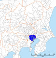 |
| Tokyo Metropolis Tokyo , ; officially , is one of the 47 prefectures of Japan. Tokyo is the capital of Japan, the center of the Greater Tokyo Area, and the largest metropolitan area of Japan. It is the seat of the Japanese government and the Imperial Palace, and the home of the Japanese Imperial Family... |
excluding Izu Izu Islands The are a group of volcanic islands stretching south and east from the Izu Peninsula of Honshū, Japan. Administratively, they form two towns and six villages; all part of Tokyo. The largest is Izu Ōshima, usually called simply Ōshima.... /Ogasawara Islands Ogasawara Islands The Bonin Islands, known in Japan as the are an archipelago of over 30 subtropical and tropical islands, some directly south of Tokyo, Japan. Administratively, they are part of Ogasawara Municipality of Ogasawara Subprefecture, Tokyo... |
13,047,446 | 1808 | 7,216.5 | Japan Statistics Bureau | 2010 Census | 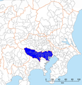 |
| Tokyo Metropolitan Employment Area Urban Employment Area is a definition of metropolitan areas, defined by the Center for Spatial Information Service, the University of Tokyo. It is different from the official definition of metropolitan areas defined by the Statistics Bureau, the Ministry of Internal Affairs and Communications... |
all municipalities that have at least 10% of their population commuting to 23 special wards Figures for this definition are complex to update without a major re-study. |
31.7 million | - | - | Center for Spatial Information Service, the University of Tokyo University of Tokyo , abbreviated as , is a major research university located in Tokyo, Japan. The University has 10 faculties with a total of around 30,000 students, 2,100 of whom are foreign. Its five campuses are in Hongō, Komaba, Kashiwa, Shirokane and Nakano. It is considered to be the most prestigious university... |
2000 | 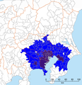 |
| Most Commonly Used Definition Misses many more distant suburbs that lay outside the prefectural borders, especially in Ibaraki Ibaraki Ibaraki may refer to any of the following places in Japan:* Ibaraki Prefecture, one of the 47 prefectures of Japan**Ibaraki, Ibaraki, a town in Ibaraki Prefecture* Ibaraki, Osaka, a city in Osaka PrefectureIt can also refer to:... and Gunma Incorporates sparsely settled rural districts like Nishitama Nishitama, Tokyo is a district in Tokyo, Japan. It comprises the following three towns and a village:*Hinohara*Hinode*Mizuho*OkutamaHistorically, the cities of Ōme, Fussa, Hamura, and Akiruno were part of Nishitama District but these are now cities and currently broke off from the District after they gained city... and even islands like Minamitorishima, 1850 km away from central Tokyo |
35,623,327 | 13,555.65 | 2,627.9 | Japan Statistics Bureau | 2010 Census | 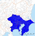 |
|
| One of the two definitions the Japan Statistics Bureau uses Consists of all municipalities that have at least 1.5% of their population aged 15 and above commuting to a designated city (Yokohama Yokohama is the capital city of Kanagawa Prefecture and the second largest city in Japan by population after Tokyo and most populous municipality of Japan. It lies on Tokyo Bay, south of Tokyo, in the Kantō region of the main island of Honshu... , Kawasaki Kawasaki, Kanagawa is a city located in Kanagawa Prefecture, Japan, between Tokyo and Yokohama. It is the 9th most populated city in Japan and one of the main cities forming the Greater Tokyo Area and Keihin Industrial Area.... , Sagamihara Sagamihara, Kanagawa is a city located in north central Kanagawa Prefecture, bordering Tokyo, Japan. It is the third most populous city in the prefecture, after Yokohama and Kawasaki, and the fifth most populous suburb of Greater Tokyo. Its northern neighbor is Machida, with which a cross-prefectural merger has been... , Chiba Chiba, Chiba is the capital city of Chiba Prefecture, Japan. It is located approximately 40 km east of the center of Tokyo on Tokyo Bay. Chiba City became a government designated city in 1992. Its population as of 2008 is approximately 960,000.... , and Saitama Saitama, Saitama ' is the capital and the most populous city of Saitama Prefecture in Japan, situated in the south-east of the prefecture. Its area incorporates the former cities of Urawa, Ōmiya, Yono and Iwatsuki. It is a city designated by government ordinance... ) or the 23 special wards Special wards of Tokyo The are 23 municipalities that together make up the core and the most populous part of Tokyo, Japan. Together, they occupy the land that was the city of Tokyo before it was abolished in 1943. The special wards' structure was established under the Japanese Local Autonomy Law and is unique to... Before Saitama became a designated city in 2001, the area was called Most locally detailed definition, but hard to update without major re-study Excludes adjacent metropolitan areas of Gunma, Ibaraki, and Utsunomiya (:ja:宇都宮都市圏) which are urbanized but have some small towns in between them and Tokyo. |
35,682,460 | Japan Statistics Bureau | 2005 | 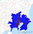 |
|||
| Set of municipalities that are completely or mostly within 50 and 70 kilometres of the Tokyo Metropolitan Government Building Tokyo Metropolitan Government Building The , also referred to as Tokyo City Hall or Tochō for short, houses the headquarters of the Tokyo Metropolitan Government, which governs not only the 23 wards, but also the cities, towns and villages that make up Tokyo as a whole.... s in Shinjuku Shinjuku, Tokyo is one of the 23 special wards of Tokyo, Japan. It is a major commercial and administrative center, housing the busiest train station in the world and the Tokyo Metropolitan Government Building, the administration center for the government of Tokyo.As of 2008, the ward has an estimated population... Suburbs tend to extend in a finger like outward along major commuter train routes and density builds along express stops, not in a uniform fashion, so these definitions aren't the most accurate definition |
31,505,458 (50 km), 35,097,758 (70 km) | - | - | Japan Statistics Bureau | 2005 | |
|
| Kantō region Kanto region The is a geographical area of Honshu, the largest island of Japan. The region includes the Greater Tokyo Area and encompasses seven prefectures: Gunma, Tochigi, Ibaraki, Saitama, Tokyo, Chiba, and Kanagawa. Within its boundaries, slightly more than 40 percent of the land area is the Kantō Plain.... |
Broad regional definition includes many rural areas | 42,607,376 | 32,423.9 | 1,314.1 | Japan Statistics Bureau | 2010 Census | 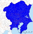 |
| National Capital Region National Capital Region (Japan) The of Japan refers to the Greater Tokyo Area as defined by the of 1956, which defines it as "Tokyo and its surrounding area declared by government ordinance." The government ordinance defined it as Tokyo and all six prefectures in the Kantō region plus Yamanashi Prefecture... |
According to the National Capital Region Planning Act Includes many rural areas Essentially Kantō plus Yamanashi |
43,470,148 | 36,889.28 | 1,178.4 | Japan Statistics Bureau | 2010 Census | 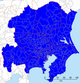 |
International Comparison
One Metropolis 3 Prefectures definition, the total size is smaller than Los Angeles County, and almost a third smaller at 13,555.65 km² than the Combined Statistical AreaCombined Statistical Area
The United States Office of Management and Budget defines micropolitan and metropolitan statistical areas. Metropolitan and micropolitan statistical areas consist of one or more counties...
of New York, at 30,671 km². and 21.9 million people.
Metropolitan Area definition ambiguities and issues
- The is a potentially ambiguous term. Informally, it may mean the One Metropolis, Three Prefectures, or the area without Saitama Prefecture. Formally, it may mean the South Kantō Block, which is not the Greater Tokyo Area, but a proportional representationProportional representationProportional representation is a concept in voting systems used to elect an assembly or council. PR means that the number of seats won by a party or group of candidates is proportionate to the number of votes received. For example, under a PR voting system if 30% of voters support a particular...
block of the national election, comprising Kanagawa, Chiba, and Yamanashi PrefectureYamanashi Prefectureis a prefecture of Japan located in the Chūbu region of the island of Honshū. The capital is the city of Kōfu.-Pre-history to the 14th century:People have been living in the Yamanashi area for about 30,000 years...
s.
- In informal occasions, the term often means Greater Tokyo Area. Officially, the term refers to a much larger area, namely the whole Kantō regionKanto regionThe is a geographical area of Honshu, the largest island of Japan. The region includes the Greater Tokyo Area and encompasses seven prefectures: Gunma, Tochigi, Ibaraki, Saitama, Tokyo, Chiba, and Kanagawa. Within its boundaries, slightly more than 40 percent of the land area is the Kantō Plain....
and Yamanashi PrefectureYamanashi Prefectureis a prefecture of Japan located in the Chūbu region of the island of Honshū. The capital is the city of Kōfu.-Pre-history to the 14th century:People have been living in the Yamanashi area for about 30,000 years...
.
- It should be noted that Tokyo as a metropolis includes some 394 km of islands (Izu IslandsIzu IslandsThe are a group of volcanic islands stretching south and east from the Izu Peninsula of Honshū, Japan. Administratively, they form two towns and six villages; all part of Tokyo. The largest is Izu Ōshima, usually called simply Ōshima....
and Ogasawara IslandsOgasawara IslandsThe Bonin Islands, known in Japan as the are an archipelago of over 30 subtropical and tropical islands, some directly south of Tokyo, Japan. Administratively, they are part of Ogasawara Municipality of Ogasawara Subprefecture, Tokyo...
), as well as some mountainous areas to the far west, which are not part of Greater Tokyo, but have comparatively very small population.
Cities within Tokyo
Tokyo is legally classified as a , a word which translates as "metropolis," and is treated as one of the forty-seven prefectures of JapanPrefectures of Japan
The prefectures of Japan are the country's 47 subnational jurisdictions: one "metropolis" , Tokyo; one "circuit" , Hokkaidō; two urban prefectures , Osaka and Kyoto; and 43 other prefectures . In Japanese, they are commonly referred to as...
. It is not administered as a single city.
Eastern Tokyo Metropolis
Central Tokyo, situated in the eastern portion of Tokyo Metropolis, was once incorporated as Tokyo CityTokyo City
was a municipality in Japan and part of Tokyo-Fu which existed from May 1, 1889 until its merger with its prefecture on July 1, 1943. The historical boundaries of Tokyo City are now occupied by independent special wards...
, which was dismantled during World War II
World War II
World War II, or the Second World War , was a global conflict lasting from 1939 to 1945, involving most of the world's nations—including all of the great powers—eventually forming two opposing military alliances: the Allies and the Axis...
. Its subdivisions have been reclassified as . The twenty three special wards currently have the legal status of cities, with individual mayors and city councils, and call themselves "cities" in English. However, when listing Japan's largest cities, Tokyo's twenty three wards are often counted as one city. See: Special wards of Tokyo
Special wards of Tokyo
The are 23 municipalities that together make up the core and the most populous part of Tokyo, Japan. Together, they occupy the land that was the city of Tokyo before it was abolished in 1943. The special wards' structure was established under the Japanese Local Autonomy Law and is unique to...
Western Tokyo Metropolis
Western TokyoWestern Tokyo
Western Tokyo, also known as the , or , consists of the part of Tokyo Prefecture to the west of the 23 special wards.-Overview:Whereas the special wards occupy the space that was formerly the city of Tokyo, western Tokyo consists of the 26 cities, three towns, and one village that were not part of...
, known as the Tama Area (Tama-chiiki 多摩地域) comprises a number of municipalities, including these suburban cities:
|
Hino, Tokyo is a city located in central Tokyo Metropolis, Japan. As of 2010, the city has an estimated population of 182,092 and a population density of 6,610 persons per km². The total area was 27.53 km².-Geography:... Inagi, Tokyo is a city located in Tokyo, Japan.As of 2008, the city has an estimated population of 81,134 and the density of 4,096.33 persons per km². The total area is 17.97 km².The city was founded on November 1, 1971.-History:... Kiyose, Tokyo is a city in Tokyo, Japan.-Demography:As of April 1, 2011, the city has an estimated population of 73,974 , the density of 7,222.87 persons per km² and there are 32,741 households in the city.-Geography:... Kodaira, Tokyo Kodaira redirects here. For the mathematician, see Kunihiko Kodaira. is a city located in the western region of Tokyo, Japan.The city has an estimated population of 180,049 with 82,179 households and a population density of 8,800.05 persons per km² as of July 1, 2011... Koganei, Tokyo is a city located in Tokyo, Japan. As of July 1, 2011, the city has an officially registered population of 116,055 with 56,296 households and a population density of 10,243.16 persons per km²... Kokubunji, Tokyo is a city in Tokyo, Japan.As of 1 June 2008, the city has an estimated population of 117,335 . The total area is 11.48 km²... Komae, Tokyo is a municipality administered as a city, in Tokyo, Japan. It is one of 30 municipalities in the western portion of Tokyo metropolis known as the Tama Area.... Kunitachi, Tokyo is a city located in the western part of the metropolitan area of Tokyo, Japan. As of October 1, 2010, the city has an estimated population of 74,623.- History :Kunitachi was founded on January 1, 1967... |
Machida, Tokyo is a city located in the western part of the greater metropolis of Tokyo, Japan. The city was founded on February 1, 1958.As of October 1, 2010, the city has an estimated population of 424,669 and a population density of 5,928.65 persons per km². The total area is 71.63 km²... (pop over 410,000) Mitaka, Tokyo is a city located in Tokyo, Japan. As of 1 November 2010, the city has an estimated population of 176,737. The total area is 16.50 km² and is about 50 – 55 meters above sea level... Musashimurayama, Tokyo is a city located in Tokyo, Japan.As of 2003, the city has an estimated population of 66,150 and the density of 4,303.84 persons per km². The total area is 15.37 km².The city was founded on November 3, 1970.... Musashino, Tokyo is a city located in Tokyo, Japan.As of October 1, 2010, the city has an estimated population of 137,222 and a population density of 12,788.63 persons per km². The total area is 10.73 km².The city was founded on November 3, 1947... Ome, Tokyo is a city located in Tokyo, Japan.As of October 1, 2010, the city has an estimated population of 139,932 and a density of 1,355.14 persons per km². The total area is 103.26 km².The characters 青梅 literally mean blue ume, or Japanese apricot.... Tachikawa, Tokyo is a city located in western Tokyo, Japan.As of February 1, 2010, the city has an estimated population of 178,064 and the density of 7,303.69 people per km². The total area is 24.38 km²... Tama, Tokyo is a municipality classified as a city, located in Tokyo, Japan.Its southern half forms part of the Tama New Town project, Japan's largest residential development, constructed in the 1970s.... |
Cities outside Tokyo
- ChibaChiba, Chibais the capital city of Chiba Prefecture, Japan. It is located approximately 40 km east of the center of Tokyo on Tokyo Bay. Chiba City became a government designated city in 1992. Its population as of 2008 is approximately 960,000....
(population 940,000) - KawasakiKawasaki, Kanagawais a city located in Kanagawa Prefecture, Japan, between Tokyo and Yokohama. It is the 9th most populated city in Japan and one of the main cities forming the Greater Tokyo Area and Keihin Industrial Area....
(population 1.36 million) - SaitamaSaitama, Saitama' is the capital and the most populous city of Saitama Prefecture in Japan, situated in the south-east of the prefecture. Its area incorporates the former cities of Urawa, Ōmiya, Yono and Iwatsuki. It is a city designated by government ordinance...
(population 1.19 million) - YokohamaYokohamais the capital city of Kanagawa Prefecture and the second largest city in Japan by population after Tokyo and most populous municipality of Japan. It lies on Tokyo Bay, south of Tokyo, in the Kantō region of the main island of Honshu...
(population 3.62 million)
The other cities in Chiba, Kanagawa and Saitama Prefectures are:
|
Isehara, Kanagawa is a city located in central Kanagawa Prefecture, Japan. As of 2010, Isehara had an estimated population of 100,976 and a density of 1,820 persons per km². The total area was 55.52 km². There is School of Medicine, Tokai University.-Geography:... Kamagaya, Chiba is a city located in northern Chiba Prefecture, Japan. As of February 2011, the city had an estimated population of 108,142 and a population density of 5120 persons per km²... Kamakura, Kanagawa is a city located in Kanagawa Prefecture, Japan, about south-south-west of Tokyo. It used to be also called .Although Kamakura proper is today rather small, it is often described in history books as a former de facto capital of Japan as the seat of the Shogunate and of the Regency during the... Kamogawa, Chiba is a city located in Chiba Prefecture, Japan.As of 2010, the city had an estimated population of 35,257 and a population density of 184 persons per km². The total area was 191.30 km²... Kashiwa, Chiba is a city located in northern Chiba Prefecture, Japan. As of February 2011, the city had an estimated population of 404,820 and a population density of 3520 persons per km²... (pop 380,000) Kasukabe, Saitama is a city in eastern Saitama, Japan, approximately north of Tokyo. It was formerly located in Kitakatsushika and Minamisaitama districts. Kasukabe once prospered as part of the Nikkō Kaidō highway, an important trade route that linked Edo with Nikkō.-Overview:... Katsuura, Chiba is a city located in southern part of Chiba Prefecture, Japan. Katsuura city is famous for Katsuura Fishing Port, which features one of the top three largest morning markets in Japan. As of February 2010, the city has an estimated population of 20,570 and the density of 218 persons per km²... Kawagoe, Saitama is a city located in Saitama Prefecture, Japan, and is about a 30-minute train ride from Ikebukuro in Tokyo.As of July 1, 2011, the city has an estimated population of 343,926... (pop 330,000) Kawaguchi, Saitama is a city located in Saitama Prefecture, Japan. The city was founded on April 1, 1933.As of January 1, 2011, the city has an estimated population of 517,171, the second largest in Saitama Prefecture after Saitama, and a population density of 9,276.61 persons per km². The total area is 55.75 km²... (pop 500,000) Kazo, Saitama is a city located in Saitama, Japan.As of April 1, 2011, the city has an estimated population of 117,339, with a household number of 42,778, and a density of 879.14 persons per km²... Kimitsu, Chiba is a city located in Chiba, Japan. As of September 2010, the city had an estimated population of 88,661 and a population density of 278 persons per km². The total area was 318.83 km².-Geography:... Kisarazu, Chiba is a city located in Chiba, Japan. As of September 2010, Kisarazu has an estimated population of 126,906 and a density of 915 persons per km². The total area was 138.73 km².... Kitamoto, Saitama is a city located in Saitama Prefecture, Japan.As of June 1, 2011, the city has an estimated population of 70,237 with 27,714 households and a population density of 3,527.42 persons per km²... Koshigaya, Saitama is a city located in Saitama Prefecture, Japan.As of 2010, the city has an estimated population of 325,074 and a population density of 5,390 persons per km². The total area is 60.31 km².... (population 318,000) Kuki, Saitama is a city located in Saitama, Japan.As of May 1, 2011, the city has an estimated population of 156,613, with a household number of 61,071, and the density of 1,900.64 persons per km²... Kumagaya, Saitama is a city in Saitama Prefecture, Japan.As of 2010, the city has an estimated population of 203,089 . The total area is 159.88 km². The city is one of the biggest in northern Saitama Prefecture. It is the administrative, business and commercial centre in northern Saitama Prefecture. Eight... Matsudo, Chiba is a city located in northern Chiba Prefecture, Japan. As of February 2011, the city had an estimated population of 484,578 and a population density of 7900 persons per km²... (pop 480,000) Minamiashigara, Kanagawa is a city located in the far southwestern corner of Kanagawa, Japan. As of 2010, the city had an estimated population of 44,190 and population density of 574 persons per km²... Misato, Saitama is a city located in Saitama Prefecture, Japan. It borders Chiba Prefecture.In January 2011, the city has an estimated population of 132,937 and a population density of 4,407.73 persons per km2. The total area is 30.16 km2.The city was founded on May 3, 1972... Miura, Kanagawa is a city located in central Kanagawa Prefecture, Japan. As of 2010, the city has an estimated population of 44,238 and a population density of 1,490 persons per km²... Mobara, Chiba is a city located in Chiba Prefecture, Japan. As of September 2010, the city has an estimated population of 92,449 and a population density of 924 persons per km². The total area is 100.01 km².-Geography:... Nagareyama, Chiba is a city located in northern Chiba Prefecture, Japan. As of February 2011, the town had an estimated population of 164,683 and a population density of 4670 persons per km²... Narashino, Chiba is a city located in northern Chiba, Japan. As of February 2011, the city had an estimated population of 164,809 and a population density of 7850 persons per km². The total area was 20.99 km².-Geography:... Narita, Chiba is a city located in Chiba Prefecture, Japan. It is the site of Narita International Airport, the main international airport serving the Greater Tokyo Area.... Niiza, Saitama is a city located in Saitama Prefecture, Japan, and is essentially a suburb of the Tokyo conurbation. Niiza is located at the southernmost part of Saitama. As of 2010, the city has an estimated population of 159,741 and a population density of 7,010 persons per km²... Noda, Chiba is a city located in the far northwestern corner Chiba Prefecture, Japan. As of February 2011, the city had an estimated population of 155,431 and a population density of 1500 persons per km²... Odawara, Kanagawa is a city located in western Kanagawa Prefecture, Japan. As of 2010, the city had an estimated population of 198,466 with a population density of 1,740 persons per km² . The total area was .-Geography:... Okegawa, Saitama is a city located in Saitama, Japan. It was founded on November 3, 1970, and as of 2003, the city has an estimated population of 73,881 and the density of 2,924.82 persons per km²... |
Sagamihara, Kanagawa is a city located in north central Kanagawa Prefecture, bordering Tokyo, Japan. It is the third most populous city in the prefecture, after Yokohama and Kawasaki, and the fifth most populous suburb of Greater Tokyo. Its northern neighbor is Machida, with which a cross-prefectural merger has been... (pop 710,000) Sakado, Saitama is a city located in Saitama Prefecture, Japan.As of 1 July 2009, the city has an estimated population of 100,942 . The total area is 40.97 km².The town of Sakado was upgraded to city status on 1 September 1976.-Adjoining cities and towns:... Sakura, Chiba is a city located in northern Chiba Prefecture, Japan. As of February 2011, the city had an estimated population of 172,176 and a population density of 1660 persons per km². The total area was 103.59 km².-Geography:... Satte, Saitama is a city located in Saitama, Japan.As of April 1, 2011, the city has an estimated population of 54,444, with a household number of 21,449 and the density of 1,603.658 persons per km². The total area is 33.95 km².The city was founded on October 1, 1986.... Sawara, Chiba was a city located in Katori District, Chiba Prefecture, Japan.Sawara has been settled since prehistoric times, and has numerous remains of Jōmon period shell middens and Kofun period burial mounds... Sayama, Saitama , formerly known as Irumagawa, is a city located in Saitama, Japan. Sayama translates as "sitting on a mountain”. The city was founded on July 1, 1954.... Shiki, Saitama is a city located in Saitama Prefecture, Japan.The city was founded on 26 October 1970. As of 1 April 2008, it has an estimated population of 69,549. The total area is 9.06 km².-Geography and transportation:... Shiroi, Chiba is a city located in northern Chiba Prefecture, Japan. As of late March 2011, the city has an estimated population of 61,073 and a population density of 1725 persons per km²... Sodegaura, Chiba is a city located in Chiba Prefecture, Japan. As of 2010, the city had an estimated population of 59,916 and a population density of 631 persons per km²... Soka, Saitama is a city located in Saitama, Japan.As of October 1, 2010, the city has an estimated population of 243,111 and the density of 8,866.19 persons per km²... Tateyama, Chiba is a city located in Chiba Prefecture, Japan. As of September 2010, the city had an estimated population of 49,315 and the population density of 447 persons per km². The total area was 110.21 km²... Toda, Saitama is a city located in Saitama, Japan. The city is located beside the Arakawa river which separates it from Tokyo. The Sasame river also flows through the city before joining the Arakawa.-History:... Togane, Chiba is a city located in Chiba, Japan. As of September 2010, the city had an estimated population of 61,169 and a population density of 685 persons per km²... Tokorozawa, Saitama is a city in Saitama, Japan. It is located in the central part of the Musashino plain, about 30 km west of downtown Tokyo. Tokorozawa can be considered part of the greater Tokyo area; its proximity to the latter and lower housing costs make it a popular bedroom community.-Location:Tokorozawa... (pop 338,000) Tomisato, Chiba is a city located in northeastern Chiba Prefecture, Japan. As of February 2011, the town had an estimated population of 50,886 and a population density of 944 persons per km²... Tsurugashima, Saitama is a city located in Saitama Prefecture, Japan.As of May 1, 2008, the city has an estimated population of 69,919 . The total area is 17.73 km².... Urayasu, Chiba is a city located in the far western corner of northern Chiba Prefecture, Japan. As of February 2011, the city had an estimated population of 164,822 and a population density of 9530 persons per km²... Wako, Saitama is a city located in the southern part of Saitama, Japan, bordering on Tokyo.As of 1 May 2008, the city has an estimated population of 76,221. The total area is 11.04 km².... Warabi, Saitama is a city located in Saitama, Japan. Warabi is the name of a bracken. The city was founded on April 1, 1959.As of 2003, the city has an estimated population of 71,034 and a density of 13,928.24 persons per km². The total area is 5.10 km²... Yachimata, Chiba is a city located in northern Chiba Prefecture, Japan. As of February 2011, the town had an estimated population of 73,118 and a population density of 977 persons per km²... Yachiyo, Chiba is a city located in northern Chiba Prefecture, Japan. As of August 2011, the town had an estimated population of 193,262 and a population density of 3769 persons per km²... Yamato, Kanagawa is a city located in central Kanagawa Prefecture, Japan. As of 2010, the city had an estimated population of 225,866 and a density of 8,320 persons per km². The total area was 27.06 km².-Surrounding municipalities:*Zama*Fujisawa*Ebina*Sagamihara*Ayase... Yashio, Saitama is a city in Saitama Prefecture, Japan.As of 2008, the city has an estimated population of 81,148 and a population density of 4,500.7 persons per km²... Yokaichiba, Chiba was a city located in northeastern Chiba Prefecture, Japan.Fukuoka Town was established on April 1, 1889 within Sōsa District, Chiba. It changed its name to Yōkaichiba on December 8, 1915. On March 31, 1954, the town expanded greatly through the annexation of the neighboring villages of Heiwa,... Yokosuka, Kanagawa is a city located in Kanagawa, Japan. As of 2010, the city had an estimated population of 419,067 and a population density of 4,160 people per km². It covered an area of 100.62 km²... (pop 420,000) Yoshikawa, Saitama is a city located in Saitama, Japan.As of May 1, 2011, the city had an estimated population of 66,773, with 25,194 households and a density of 2,111.73 persons per km². The total area is 31.62 km².The city incorporated as a city on April 1, 1996... Yotsukaido, Chiba is a city located in northern Chiba Prefecture, Japan. As of February 2011, the town had an estimated population of 86,911 and a population density of 2500 persons per km²... Zama, Kanagawa is a city located in central Kanagawa Prefecture, Japan. The city is also home to the United States' Camp Zama Army base. As of 128,989, the city had an estimated population of 128,989 and a density of 7,320 persons per km². The total area was 17.58 km².... Zushi, Kanagawa is a city located in Kanagawa, Japan. As of 2010, the city had an estimated population of 58,793 and a population density of 3,390 persons per km². The total area was 17.34 km².-Geography:... |
source: stat.go.jp census 2005
Additional cities
In the major metropolitan area (MMA) definition used by the Japanese Statistics Bureau, the following cities in IbarakiIbaraki Prefecture
is a prefecture of Japan, located in the Kantō region on the main island of Honshu. The capital is Mito.-History:Ibaraki Prefecture was previously known as Hitachi Province...
, Tochigi
Tochigi Prefecture
is a prefecture located in the Kantō region on the island of Honshū, Japan. The capital is the city of Utsunomiya.Nikkō, whose ancient Shintō shrines and Buddhist temples UNESCO has recognized by naming them a World Heritage Site, is in this prefecture...
, Gunma
Gunma Prefecture
is a prefecture of Japan located in the northwest corner of the Kantō region on Honshu island. Its capital is Maebashi.- History :The remains of a Paleolithic man were found at Iwajuku, Gunma Prefecture, in the early 20th century and there is a public museum there.Japan was without horses until...
, Yamanashi
Yamanashi Prefecture
is a prefecture of Japan located in the Chūbu region of the island of Honshū. The capital is the city of Kōfu.-Pre-history to the 14th century:People have been living in the Yamanashi area for about 30,000 years...
, and Shizuoka
Shizuoka Prefecture
is a prefecture of Japan located in the Chūbu region on Honshu island. The capital is the city of Shizuoka.- History :Shizuoka prefecture was formed from the former Tōtōmi, Suruga and Izu provinces.The area was the home of the first Tokugawa Shogun...
Prefectures are included:
Ibaraki Prefecture
|
Koga, Ibaraki is a city located in Ibaraki, Japan.-Old City of Koga:The city has its origins in the Tokugawa period when a castle was built in the 16th century at the river crossing point and a town sprang up around it. The site of the castle is still visible near Koga 1st elementary school. The modern city was... Moriya, Ibaraki is a city located in Ibaraki, Japan.As of May 1, 2011, the city has an estimated population of 62,716, with a household number of 23,311, and the density of 1,760.20 persons per km². The total area is 35.63 km²... Ryugasaki, Ibaraki is a city located in Ibaraki, Japan.-Overview:As of April 1, 2011, the city has an estimated population of 79,269, with household number being 30,470, and a population density of . The total area is .... Toride, Ibaraki is a city located in Ibaraki, Japan.As of March 1, 2008 , the city has an estimated population of 109,926 and the density of 1,570 persons per km². The total area is 69.96 km².... |
Tsuchiura, Ibaraki is a city located in Ibaraki prefecture, in Japan. It is situated along the western shores of Lake Kasumigaura, the second largest lake in Japan. Tokyo city lies about 60 km to the south, and Tsukuba science city borders Tsuchiura to the west.-Demographics:... Tsukuba, Ibaraki is a city located in Ibaraki Prefecture, Japan. It is known as the location of the , a planned city developed in the 1960s.As of 2008, the city has an estimated population of 207,394 and a population density of 730 persons per km². Its total area is 284.07 km².Mount Tsukuba, particularly well-known... Ushiku, Ibaraki is a city located in Ibaraki, Japan.As of 2010, the city has an estimated population of 81,532 and a density of 1,380 persons per km². The total area is 58.88 km².... |
Border areas
Tighter definitions for Greater Tokyo do not include adjacent metropolitan areas of NumazuNumazu, Shizuoka
is a city located in eastern Shizuoka Prefecture, Japan. As of 2009, the city has an estimated population of 205,636 and a population density of 1,100 persons per km². The total area was 187.11 km².- Geography:...
-Mishima
Mishima, Shizuoka
is a city located in eastern Shizuoka Prefecture, Japan. As of 2009, the city has an estimated population of 112,078 and a population density of 1,800 persons per km². The total area is 62.13 km²...
(approx. 450,000) to the southwest, Maebashi
Maebashi, Gunma
is the capital city of Gunma Prefecture, Japan.The city was founded on April 1, 1892, by the samurai Makuba Kawai.On December 5, 2004 the town of Ōgo, and the villages of Kasukawa and Miyagi, all from Seta District, were merged into Maebashi....
-Takasaki
Takasaki, Gunma
is a city located in Gunma Prefecture, Japan.The city was founded on April 1, 1900.Takasaki is a regional transportation hub because its train station is the junction of several rail lines as well as a Shinkansen stop....
-Ōta
Ota, Gunma
is a city 50 miles northwest of Tokyo, in eastern Gunma prefecture, Japan. This city is located between the Tone and Watarase rivers. As a result, the new city reached a total population of 219,789, making it the third most populous city in Gunma....
-Ashikaga
Ashikaga, Tochigi
is a city located in Tochigi Prefecture, Japan. Ashikaga is located north of Tokyo.As of April 1, 2011, the city has an estimated population of 153,766, with a household number of 59,219, and a density of 864.73 persons per km²...
(approx. 1,500,000 people) on the northwest, and Greater Utsunomiya
Utsunomiya, Tochigi
is the capital and most populous city of Tochigi Prefecture, Japan. In October 2010 the city had an estimated population of 510,416 and a population density of 1,224.49 people per square kilometer. The total area is 416.84 km². had a population of 888,005 in the 2000 Census...
(:ja:宇都宮都市圏) approx. 1,000,000) to the north. If they are included, Greater Tokyo's population would be around 39 million.
Geography
Tokyo Station
is a train station located in the Marunouchi business district of Chiyoda, Tokyo, Japan, near the Imperial Palace grounds and the Ginza commercial district....
) are the 23 special wards, formerly treated as a single city but now governed as separate municipalities, and containing many major commercial centres such as Shinjuku, Shibuya
Shibuya, Tokyo
is one of the 23 special wards of Tokyo, Japan. As of 2008, it has an estimated population of 208,371 and a population density of 13,540 persons per km². The total area is 15.11 km²....
, Ikebukuro
Ikebukuro
is a commercial and entertainment district in Toshima, Tokyo, Japan. Toshima ward offices, Ikebukuro station, and several shops, restaurants, and enormous department stores are located within city limits....
and Ginza
Ginza
is a district of Chūō, Tokyo, located south of Yaesu and Kyōbashi, west of Tsukiji, east of Yūrakuchō and Uchisaiwaichō, and north of Shinbashi.It is known as an upscale area of Tokyo with numerous department stores, boutiques, restaurants and coffeehouses. Ginza is recognized as one of the most...
. Around the 23 special wards are a multitude of suburban cities which merge seamlessly into each other to form a continuous built up area, circumnavigated by the heavily-travelled Route 16
Route 16 (Japan)
National Route 16 is a national highway in Japan. A beltway around Tokyo, it links the major prefectural capital cities of Yokohama , Saitama , and Chiba as well as Hachiōji . It also serves Yokosuka and Sagamihara , Kasukabe , and Kisarazu...
which forms a (broken) loop about 40 km from central Tokyo. Situated along the loop are the major cities of Yokohama (to the south of Tokyo), Hachiōji (to the west), Ōmiya (now part of Saitama City, to the north), and Chiba (to the east). Within the Route 16 loop, the coastline of Tokyo Bay
Tokyo Bay
is a bay in the southern Kantō region of Japan. Its old name was .-Geography:Tokyo Bay is surrounded by the Bōsō Peninsula to the east and the Miura Peninsula to the west. In a narrow sense, Tokyo Bay is the area north of the straight line formed by the on the Miura Peninsula on one end and on...
is heavily industrialised, with the Keihin Industrial Area stretching from Tokyo down to Yokohama, and the Keiyō Industrial Area from Tokyo eastwards to Chiba. Along the periphery of the main urban area are numerous new suburban housing developments such as the Tama New Town
Tama New Town
is a large residential development, straddling the municipalities of Hachiōji, Tama, Inagi and Machida cities, in Tokyo, Japan. It was designed as a new town in 1965...
. The landscape is relatively flat compared to most of Japan, most of it comprising low hills.
Outside the Route 16 loop the landscape becomes more rural. To the southwest is an area known as Shōnan
Shonan
is the name of a region along the coast of Sagami Bay in central Japan. Centered on Enoshima, an island about 50 kilometers southwest of Tokyo, the Shōnan region stretches from Ōiso in the west to Hayama in the east, including Chigasaki, Kamakura and Hiratsuka...
comprising various cities and towns along the coast of Sagami Bay
Sagami Bay
Sagami Bay , also known as the Sagami Gulf or Sagami Sea, lies south of Kanagawa Prefecture in Honshū, central Japan, contained within the scope of the Miura Peninsula, in Kanagawa, to the east, the Izu Peninsula, in Shizuoka Prefecture, to the west, and the Shōnan coastline to the north, while the...
, with their long beaches comprising black volcanic sand, and to the west the area is mountainous.
Many rivers run through the area, the major ones being Arakawa
Arakawa River
The is one of the principal rivers flowing through Tokyo, the capital city of Japan. The point of origin is on Mount Kobushi in Saitama Prefecture, and the Arakawa River empties into Tokyo Bay, spanning 173 kilometers. The drainage basin covers 2,940 square kilometers...
and Tama River
Tama River
The is a major river in Yamanashi, Kanagawa and Tokyo Prefectures on Honshū, Japan. It is officially classified as a Class 1 river by the Japanese government....
.
Economy
Tokyo has the largest city economy in the world and one of three command centers along with New York City and London.Greater Tokyo Area 2005
- 2005 average exchange rate (1 US Dollar = 110.22 Yen)
Prefecture Gross Prefecture Product
(in billion Yen)Gross Prefecture Product
(in billion US$)Tokyo 92,269 837 Kanagawa 31,184 282 Saitama Saitama Prefectureis a prefecture of Japan located in the Kantō region of the island of Honshu. The capital is the city of Saitama.This prefecture is part of the Greater Tokyo Area, and most of Saitama's cities can be described as suburbs of Tokyo, to which a large amount of residents commute each day.- History...20,650 187 Chiba Chiba Prefectureis a prefecture of Japan located in the Kantō region and the Greater Tokyo Area. Its capital is Chiba City.- History :Chiba Prefecture was established on June 15, 1873 with the merger of Kisarazu Prefecture and Inba Prefecture...19,917 180 Ibaraki Ibaraki Prefectureis a prefecture of Japan, located in the Kantō region on the main island of Honshu. The capital is Mito.-History:Ibaraki Prefecture was previously known as Hitachi Province...10,955 99 Tochigi Tochigi Prefectureis a prefecture located in the Kantō region on the island of Honshū, Japan. The capital is the city of Utsunomiya.Nikkō, whose ancient Shintō shrines and Buddhist temples UNESCO has recognized by naming them a World Heritage Site, is in this prefecture...8,195 74 Gunma Gunma Prefectureis a prefecture of Japan located in the northwest corner of the Kantō region on Honshu island. Its capital is Maebashi.- History :The remains of a Paleolithic man were found at Iwajuku, Gunma Prefecture, in the early 20th century and there is a public museum there.Japan was without horses until...7,550 68 Yamanashi Yamanashi Prefectureis a prefecture of Japan located in the Chūbu region of the island of Honshū. The capital is the city of Kōfu.-Pre-history to the 14th century:People have been living in the Yamanashi area for about 30,000 years...3,206 29 The One Metropolis
and Three Prefectures164,020 1,488 National Capital Region 193,926 1,759
Source
GDP (purchasing power parity) 2005
Purchasing power parity
In economics, purchasing power parity is a condition between countries where an amount of money has the same purchasing power in different countries. The prices of the goods between the countries would only reflect the exchange rates...
in the world in 2005 according to a study by PricewaterhouseCoopers
PricewaterhouseCoopers
PricewaterhouseCoopers is a global professional services firm headquartered in London, United Kingdom. It is the world's largest professional services firm measured by revenues and one of the "Big Four" accountancy firms....
.
| Rank | Urban agglomerations | Country | GDP(PPP) (in billion US$) |
|---|---|---|---|
| 1 | Tokyo Tokyo , ; officially , is one of the 47 prefectures of Japan. Tokyo is the capital of Japan, the center of the Greater Tokyo Area, and the largest metropolitan area of Japan. It is the seat of the Japanese government and the Imperial Palace, and the home of the Japanese Imperial Family... |
 Japan Japan |
|
| 2 | New York City New York City New York is the most populous city in the United States and the center of the New York Metropolitan Area, one of the most populous metropolitan areas in the world. New York exerts a significant impact upon global commerce, finance, media, art, fashion, research, technology, education, and... |
 United States United States |
|
| 3 | Los Angeles Los Ángeles Los Ángeles is the capital of the province of Biobío, in the commune of the same name, in Region VIII , in the center-south of Chile. It is located between the Laja and Biobío rivers. The population is 123,445 inhabitants... |
United States |
|
| 4 | Chicago Chicago Chicago is the largest city in the US state of Illinois. With nearly 2.7 million residents, it is the most populous city in the Midwestern United States and the third most populous in the US, after New York City and Los Angeles... |
United States |
|
| 5 | Paris Paris Paris is the capital and largest city in France, situated on the river Seine, in northern France, at the heart of the Île-de-France region... |
 Early Modern France Early Modern France |
|
| 6 | London London London is the capital city of :England and the :United Kingdom, the largest metropolitan area in the United Kingdom, and the largest urban zone in the European Union by most measures. Located on the River Thames, London has been a major settlement for two millennia, its history going back to its... |
 United Kingdom United Kingdom |
|
| 7 | Osaka Osaka is a city in the Kansai region of Japan's main island of Honshu, a designated city under the Local Autonomy Law, the capital city of Osaka Prefecture and also the biggest part of Keihanshin area, which is represented by three major cities of Japan, Kyoto, Osaka and Kobe... |
Japan |
|
| 8 | Mexico City Mexico City Mexico City is the Federal District , capital of Mexico and seat of the federal powers of the Mexican Union. It is a federal entity within Mexico which is not part of any one of the 31 Mexican states but belongs to the federation as a whole... |
 Mexico Mexico |
|
| 9 | Philadelphia | United States |
|
| 10 | Washington, D.C. Washington, D.C. Washington, D.C., formally the District of Columbia and commonly referred to as Washington, "the District", or simply D.C., is the capital of the United States. On July 16, 1790, the United States Congress approved the creation of a permanent national capital as permitted by the U.S. Constitution.... |
United States |
|
Transportation
Air
The Greater Tokyo Area has two major airports, Tokyo International AirportTokyo International Airport
, commonly known as , is one of the two primary airports that serve the Greater Tokyo Area in Japan. It is located in Ōta, Tokyo, south of Tokyo Station....
, commonly known as Haneda Airport (chiefly domestic) and Narita International Airport
Narita International Airport
is an international airport serving the Greater Tokyo Area of Japan. It is located east of Tokyo Station and east-southeast of Narita Station in the city of Narita, and the adjacent town of Shibayama....
(chiefly international). Minor facilities include the Chōfu
Chofu Airport
is an airport located northwest Chōfu, Tokyo, Japan, west of central Tokyo. It is administered by the Tokyo Metropolitan Government. The airport's main commercial activity is New Central Airlines commuter flights to the islands south of Tokyo....
and Honda Airport
Honda Airport
is a private airfield in the town of Kawajima, Hiki District, and the city of Okegawa, both in Saitama Prefecture, Japan. Another name for it is Okegawa Airfield. The operator is Honda Airways, a subsidiary of Honda Motor Co. Ltd.-Data:...
. Tokyo Heliport
Tokyo Heliport
is a heliport in Kōtō, Tokyo, Japan, mainly used for chartered flights in the Greater Tokyo Area.Access to the airport is through Shin-Kiba Station. Approximately 15 companies do business at this heliport...
serves helicopter traffic, including police, fire, and news. Various military facilities handle air traffic: Naval Air Facility Atsugi
Naval Air Facility Atsugi
is a naval air base located in the cities of Yamato and Ayase in Kanagawa Prefecture, Japan. It is the largest United States Navy air base in the Pacific Ocean and houses the squadrons of Carrier Air Wing 5, which deploys with the aircraft carrier...
(United States Navy
United States Navy
The United States Navy is the naval warfare service branch of the United States Armed Forces and one of the seven uniformed services of the United States. The U.S. Navy is the largest in the world; its battle fleet tonnage is greater than that of the next 13 largest navies combined. The U.S...
and Japan Maritime Self-Defense Force
Japan Maritime Self-Defense Force
The , or JMSDF, is the naval branch of the Japan Self-Defense Forces, tasked with the naval defense of Japan. It was formed following the dissolution of the Imperial Japanese Navy after World War II....
), Hyakuri Airfield
Hyakuri Airfield
Ibaraki Airport is an airport in the city of Omitama, Ibaraki Prefecture, Japan. It also serves as air base for the Japan Air Self-Defense Force under the name Hyakuri Air Base. The airport was known as prior to March 2010, when civil aviation operations began...
(Japan Air Self-Defense Force
Japan Air Self-Defense Force
The , or JASDF, is the aviation branch of the Japan Self-Defense Forces responsible for the defense of Japanese airspace and other aerospace operations. The JASDF carries out combat air patrols around Japan, while also maintaining an extensive network of ground and air early warning radar systems...
), Yokota Air Base
Yokota Air Base
, is a United States Air Force base in the city of Fussa, one of 26 cities in the Tama Area, or Western Tokyo.The base houses 14,000 personnel. The base occupies a total area of and has a runway...
(United States Air Force
United States Air Force
The United States Air Force is the aerial warfare service branch of the United States Armed Forces and one of the American uniformed services. Initially part of the United States Army, the USAF was formed as a separate branch of the military on September 18, 1947 under the National Security Act of...
), and Camp Zama
Camp Zama
is a United States Army post located in the cities of Zama and Sagamihara, in Kanagawa Prefecture, Japan, about southwest of Tokyo.Camp Zama is home to the U.S. Army Japan /I Corps , the U.S. Army Japan Aviation Detachment "Ninjas" , the 500th Military Intelligence Brigade, the Japan Engineer...
(United States Army
United States Army
The United States Army is the main branch of the United States Armed Forces responsible for land-based military operations. It is the largest and oldest established branch of the U.S. military, and is one of seven U.S. uniformed services...
). Hyakuri is being developed for civil aviation with plans for service to begin in March 2010; it will be called Ibaraki Airport.
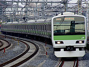
Rail
Greater Tokyo has an extensive railway network comprising high-speed railShinkansen
The , also known as THE BULLET TRAIN, is a network of high-speed railway lines in Japan operated by four Japan Railways Group companies. Starting with the Tōkaidō Shinkansen in 1964, the network has expanded to currently consist of of lines with maximum speeds of , of Mini-shinkansen with a...
, commuter rails, subway
Rapid transit
A rapid transit, underground, subway, elevated railway, metro or metropolitan railway system is an electric passenger railway in an urban area with a high capacity and frequency, and grade separation from other traffic. Rapid transit systems are typically located either in underground tunnels or on...
s, monorail
Monorail
A monorail is a rail-based transportation system based on a single rail, which acts as its sole support and its guideway. The term is also used variously to describe the beam of the system, or the vehicles traveling on such a beam or track...
s, private lines
Private railway
A private railroad is a railroad run by a private corporation, as opposed to a railroad run by a public sector.-Japan:In Japan, refers to a railway line owned and operated by private sector. Although Japan Railways Group companies are private entities, they are not considered private railways...
, tram
Tram
A tram is a passenger rail vehicle which runs on tracks along public urban streets and also sometimes on separate rights of way. It may also run between cities and/or towns , and/or partially grade separated even in the cities...
s and others. There are around 136 individual rail lines in the Greater Tokyo Area, and between 1,000 to 1,200 railway stations depending on one's definition of the area, most designed for heavy use, usually long enough to accommodate 10-car trains. Major stations are designed to accommodate hundreds of thousands of passengers at any given time, with miles of connecting tunnels linking vast department stores and corporate offices. Tokyo Station
Tokyo Station
is a train station located in the Marunouchi business district of Chiyoda, Tokyo, Japan, near the Imperial Palace grounds and the Ginza commercial district....
has underground connections that stretch well over 4 kilometers, and Shinjuku Station
Shinjuku Station
is a train station located in Shinjuku and Shibuya wards in Tokyo, Japan.Serving as the main connecting hub for rail traffic between central Tokyo and its western suburbs on inter-city rail, commuter rail and metro lines, the station was used by an average of 3.64 million people per day in 2007,...
has well over 200 exits. Greater Tokyo's Railway Network is easily considered the world's largest in terms of both daily passenger throughput with a daily trips of over 40 million (20 million different passengers) as well as physical extent with approximately 2,578 kilometers of track. Some 57 percent of all Greater Tokyo residents used rail as their primary means of transport in 2001.
JR East
East Japan Railway Company
is the largest passenger railway company in the world and one of the seven Japan Railways Group companies. The company name is officially abbreviated as JR East in English, and as in Japanese. The company's headquarters are in Yoyogi, Shibuya, Tokyo....
and many other carriers crisscross the region with a network of rail lines. (See this map showing the Suica
Suica
is a rechargeable contactless smart card used as a fare card on train lines in Japan. Launched in November 2001, the card is usable currently in the Kantō region, at JR East stations near Sendai and Niigata...
/PASMO
PASMO
is a rechargeable contactless smart card ticketing system for public transport introduced in Tokyo, Japan, on March 18, 2007.Pasmo is a development of the system used by many non JR railway lines in the Tokyo region...
accepting area that roughly corresponds with Greater Tokyo). The most important carriers include Keihin Kyūkō Electric Railway
Keihin Electric Express Railway
, also known as or, more recently, , is a private railroad that connects inner Tokyo to Kawasaki, Yokohama, Yokosuka and other points on the Miura Peninsula in Kanagawa Prefecture. It also provides rail access to Haneda Airport in Tokyo. means the Tokyo - Yokohama area. The company's railway...
(Keikyū), Keisei Electric Railway
Keisei Electric Railway
The is a major private railway in Chiba and Tokyo, Japan. The name Keisei is the combination of the kanji 京 from and 成 from , which the railways main line connects. The combination uses different readings than the ones used in the city names. The railway's main line runs from Tokyo to Narita and...
, Keiō Electric Railway, Odakyū Electric Railway
Odakyu Electric Railway
, or OER, is a major railway company based in Tokyo, Japan best known for its Romancecar series of limited express trains from Tokyo to Odawara, Enoshima, Tama New Town, and Hakone....
, Seibu Railway
Seibu Railway
is a conglomerate based in Tokorozawa, Japan, with principal business areas in railways, tourism and real estate. Seibu Railway's operations are concentrated in northwest Tokyo and Saitama Prefecture; the name "Seibu" is an abbreviation of "west Musashi," referring to the historic name for this area...
, Tōbu Railway
Tobu Railway
is a Japanese commuter railway company in the Greater Tokyo Area as well as an intercity and regional operator in the Kantō region. It operates in Tokyo, Saitama, Chiba, Tochigi, and Gunma Prefectures...
, and Tōkyū Corporation. In addition to Tokyo's two subway systems — Tokyo Metro
Tokyo Metro
is one of two rapid transit systems making up the Tokyo subway system, the other being Toei. It is the most used subway system in the world in terms of annual passenger rides.-Organization:...
and Tokyo Metropolitan Bureau of Transportation
Tokyo Metropolitan Bureau of Transportation
The is Tokyo's public transportation authority. Its subway lines are commonly described as 都営 Toei, meaning "operated by the metropolitan government ." It is one of two rapid transit systems making up the Tokyo subway system, the other being Tokyo Metro.-Toei Subway:The lines were originally...
(Toei and Toden
Tokyo Toden
The or simply Toden, is the streetcar network of Tokyo, Japan. Of all its former routes, only one, the Toden Arakawa Line, remains in service. The Tokyo Metropolitan Bureau of Transportation operates the Toden...
lines), Yokohama operates three lines
Yokohama Municipal Subway
is the metro network in the city of Yokohama, Japan, south of Tokyo In Kanagawa pref. It is operated by Yokohama City Transportation Bureau, and is operated as two lines, though 3 continuous lines exist.-Lines:Line 1 and 3 are operated as a single line...
. The Tokyo Monorail
Tokyo Monorail
, officially the , is a monorail system connecting Haneda Airport in Ōta, Tokyo, Japan, to Hamamatsuchō Station in Minato, Tokyo. The trains operate along an elevated line that follows the coast of Tokyo Bay. The trip from the airport to Hamamatsuchō costs ¥470 each way.-History:The line opened in...
provides service to Haneda Airport and other destinations.
Other
The Shuto ExpresswayShuto Expressway
is a network of toll expressways in the Greater Tokyo Area of Japan. It is operated and maintained by the .Most routes consist of elevated roadway above other roads or over water, and have many sharp curves which require caution to drive safely...
system connects other national expressways
Expressways of Japan
The expressways of Japan make up a large network of freeway-standard toll roads.- History :Following World War II, Japan's economic revival led to a massive increase in personal automobile use...
in the capital region.
Tokyo and Yokohama are major commercial seaports, and both the Maritime Self-Defense Force and United States Navy
United States Navy
The United States Navy is the naval warfare service branch of the United States Armed Forces and one of the seven uniformed services of the United States. The U.S. Navy is the largest in the world; its battle fleet tonnage is greater than that of the next 13 largest navies combined. The U.S...
maintain naval bases at Yokosuka.
See also
- List of metropolitan areas in Asia by population
- List of metropolitan areas in Japan by population
- National Capital Region (Japan)National Capital Region (Japan)The of Japan refers to the Greater Tokyo Area as defined by the of 1956, which defines it as "Tokyo and its surrounding area declared by government ordinance." The government ordinance defined it as Tokyo and all six prefectures in the Kantō region plus Yamanashi Prefecture...
briefly shows the two definitions of the "Capital Area" (Shuto-ken.)