

River Hull
Encyclopedia
The River Hull is a navigable river
in the East Riding of Yorkshire
in the north of England. It rises from a series of springs to the west of Driffield
, and enters the Humber
estuary at Kingston upon Hull
. Following a period when the Archbishops of York charged tolls for its use, it became a free navigation. The upper reaches became part of the Driffield Navigation
from 1770, after which they were again subject to tolls, and the section within the city of Hull came under the jurisdiction of the Port of Hull, with the same result.
Most of its course is through low lying land that is at or just above sea level, and flooding has been a long-standing problem. Drainage schemes to alleviate it were constructed on both sides of the river. The Holderness Drainage scheme to the east was completed in 1772, with a second phase in 1805, and the Beverley and Barmston Drain to the west was completed in 1810. Since 1980, the mouth of the river has been protected by a tidal barrier, which can be closed to prevent tidal surges entering the river system and causing flooding.
Most of the bridges which cross the river are movable, in order to allow shipping to pass. There are five swing bridges, with a sixth one expected to open in 2011, four bascule bridge
s, two of which have twin leaves, one for each carriageway of the roads which they carry, and three Scherzer lift bridges, which are a type of rolling bascule bridge. Scott Street Bridge, which is now permanently raised, was originally powered from a high pressure water main maintained by the first public power distribution company in the world.
. It rises from a series of springs to the west of Driffield, near the site of the medieval village of Elmswell. The Elmswell Beck flows eastwards from these, and is joined by the Little Driffield Beck, which flows southwards from Little Driffield. It continues as the Driffield Beck, flowing around the south-western edge of Driffield
, where it is joined by the Driffield Trout Stream. After the junction, it becomes the River Hull or the West Beck and flows to the east, before turning south to reach Corps Landing. For much of the route below Driffield, the Driffield Navigation
runs parallel to the river.
The river from Corps Landing to its mouth is navigable. At Emmotland
, it is joined by the Frodingham Beck, which is also navigable, and leads to the canal into Driffield which forms the major part of the Driffield Navigation. Scurf Dyke joins from the west, and is followed by Struncheon Hill lock, which marks the end of the Navigation, and the official start of the navigable River Hull. Below here, the river is tidal, and the tidal range of spring tides can be up to 7 feet (2.1 m) in winter and 4 feet (1.2 m) in summer. Just above the lock, the Beverley and Barmston Drain, which collects water from the catchwater drains on either side of the main channel, flows under the navigation in a tunnel, and runs just to the west of the river almost to its mouth. Below the lock, the surrounding land is almost at sea level, and the river is constrained by flood banks on both sides.
On its route southwards, the river passes the former junction with Aike Beck
, once navigable to Lockington Landing, but the stream was subsequently re-routed to join the Arram Beck
. The Leven Canal
used to join on the east bank, but the entrance lock has been replaced by a sluice. The Arram Beck flows in from the west, and then the river is crossed by Hull Bridge, the cause of repeated disagreement between the owners of the Driffield Navigation, and the Corporation of Beverley
, who owned the bridge. Just above Beverley Beck
, which joins from the west, is Grovehill bridge, now a lift bridge but once a ferry bridge.
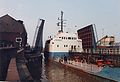
 Once the river reaches the outskirts of Hull, its course is marked by a series of bridges, most of which open to allow boats to pass. There are swing bridges, lift bridges and bascule bridges, and the river becomes part of the Port of Hull. The river, which is the dividing line between West and East Hull, bisects the city's industrial area, and the bridges cause traffic delays during high tides, though river traffic is less than it once was. The Beverley and Barmston Drain rejoins the river above Scott Street Bridge. Below North Bridge, an unused dry dock on the west bank marks the former entrance to Queens Dock, and below Drypool Bridge, a muddy basin on the east bank was once the entrance to Drypool Basin and Victoria Dock. The river reaches its confluence
with the Humber
estuary
in the centre of Kingston upon Hull
. At its mouth, a tidal barrier has been constructed to prevent tidal surges from entering the river, which can flood the town and the flat countryside to the north.
laid claim to the river, and declared their right to navigate on a 24 feet (7.3 m) channel. A number of fish-weirs
made navigation difficult, and the Archbishop negotiated their removal in 1296, so that a wharf could be established at Grovehill, to serve the town of Beverley
. By 1321, river rights had been extended to the charging of tolls. One-third of a shilling
(1.7 p) was charged for each bushel
carried on the river between Emmotland and the Humber, but the merchants of Hull were unhappy with this, and eventually, it became a free navigation, on which goods could be carried without toll. The Arram Beck was also exempt from all tolls. It has remained free, except for 1 miles (1.6 km) from the mouth, which is part of the Port of Hull and is under the control of Hull Corporation.
The lower river was bordered by salt marsh
es in medieval times, when efforts were first made to drain them. Further upstream, channels were cut through the fens in the twelfth and thirteenth centuries by the monks of Meaux Abbey
, primarily to enable travel by boat, but these gradually became part of the drainage system. John Smeaton
, when asked by the merchants of Driffield to advise on ways to allow keels
to reach their town, suggested a small cut of about 1.2 miles (1.9 km) including one lock, from the river near Wansford
. The merchants sought a second opinion, and John Grundy, Jr.
suggested a much longer canal, running for 5 miles (8 km) from Fisholme
on the Frodingham Beck. When fully opened in 1770, the new route was some 3 miles (4.8 km) shorter than the river, which follows an extremely winding course in its upper reaches. The river above Aike was now considered to be part of the Driffield Navigation, and tolls were charged for its use.
Although beyond their jurisdiction, the Navigation commissioners attempted to extend their powers, to improve the river below the junction with Aike Beck. They particularly wanted to replace the stone Hull Bridge, near Beverley, with a swing bridge, which would make it easier for keels to reach Frodingham bridge. The Corporation of Beverley objected, because the bridge was the main route of communication between Beverley and Holderness
, and the commissioners instead dredged parts of the river to improve access. Plans to improve Hull Bridge were again resisted by Beverley Corporation in 1799, but an agreement was finally reached in 1801, and an Act of Parliament
was obtained in July of that year. William Chapman
acted as engineer, as the act authorised the construction of towpaths, a new cut between Bethels Bridge and the lock at Struncheon Hill, to avoid a long loop in the river, and rebuilding of the bridge. The bridge cost £500, half of which was met by Richard Bethell, the owner of the Leven Canal
, on condition that the tolls for passing through it were reduced significantly.
 Passage through Hull had long been difficult, because of the number of ships which used the river for loading and unloading goods. In 1794, the merchants of Beverley had advocated the building of docks at Hull, with a separate entrance, so that traffic to the upper river would not be impeded, while the Driffield Navigation had unsuccessful attempted to get a clause inserted into the Act of Parliament which the Hull Dock Company
obtained in 1840, to ensure free passage for vessels, and the removal of tolls for boats not actually using the docks. The Navigation Company also received complaints from the Beverley and Barmston Drainage Commissioners, who believed that water levels were being kept at a higher level than was good for drainage.
In 1980, the Environment Agency
constructed a tidal barrier at the mouth of the river. The structure spans the river, and a huge steel gate, weighing 202 tonnes, can be lowered into the waterway, effectively sealing the river from the Humber, and preventing tidal surges from moving up the river and flooding parts of the city and the low lying areas beyond. The gate is lowered between eight and twelve times a year, and protects around 17,000 properties. In 2009, a £10 million upgrade of the structure was started, to ensure it would stay operational for a further 30 years. The upgrade included a new drive mechanism, which raises and lowers the gate, and pivots it when it is at the top of the structure, so that it lies horizontally rather than vertically. It also included a new control system. Plans have been considered to build a barrage
at the mouth of the Hull where it joins the Humber
Estuary
to maintain a constant water level as it passes through the city. The idea was first raised by the Abercrombie report
, which considered how to redevelop Hull after significant destruction during the Second World War. The estimated cost of such a project was around £195 million in 2007.
 Because the river was a free river, there are no figures for traffic on the lower river. However, it connected to a number of waterways on which tolls were collected, and so an indication of the traffic can be gained from the figures for these waterways. The main cargoes on Beverley Beck in 1730 were coal, bricks, turfs and wool, together with cereal crops, consisting of wheat, barley, oats and malt. Receipts from tolls more than doubled between 1732 and 1748, after which the tolls were let to an independent collector. The annual rent charged for this privilege doubled again between 1748 and 1792. There was a steady expansion of trade on the Driffield Navigation during the same period, as the dividends paid to shareholders rose from 1.5 to 4 per cent. In 1789, Bainton, Boyes and Co negotiated a lump sum payment to cover coal from the Aire and Calder Navigation
to their new carpet factory and the export of their carpets in the downstream direction. The factory later became a corn mill.
Toll rentals continued to increase on the Beverley Beck, rising from £190 to £435 between 1793 and 1835. Some 31,185 tons of cargo were carried in 1838.
In 1817, a steam packet service started to run between Driffield and Hull. Three return trips each week were made, but the journey times were too long, and an advertisement in 1825 indicated that the engine had been altered and an express steam packet service would commence. Three boats were recorded as trading between Driffield and Hull every other day in a directory of Yorkshire published in 1823. Traffic for 1832 included 7,394 chaldron
s of coal, 18,173 quarters of wheat, 7,745 quarters of oats, 19,396 quarters of barley and 4,555 sacks of flour. An additional 1,564 quarters of wheat and 8,194 sacks of flour were carried to or from Foston Mill, reached from Frodingham Beck. A regular carrier also operated between the Leven Canal and Hull once a week.
Between 1848 and 1905, traffic on Beverley Beck more than trebled, from 33,498 tons to 101,540 tons. Coal and other minerals accounted for around one quarter of the traffic in 1905, while goods carried in 1906 included fertiliser, burnt ore, flour and scrap metal. Commercial traffic continued into the 1970s, when tolls of £2,365 were collected on 28,169 tons of cargo. Traffic on the Driffield Navigation was relatively steady between 1871 and 1905, falling slightly from 35,654 to 32,666 tons. Goods carried included coal, linseed, cottonseed, wheat, flour and artificial manures. In 1922, £7 of income was received from pleasure craft using the navigation. Traffic declined during the 1930s, with commercial traffic finally ceasing in 1944. The Leven canal carried 4,242 tons in 1888 and 4,546 in 1905, but then succumbed to road competition, and closed in 1935.
 The problems of flooding of the land adjacent to the river were addressed by the construction of catchwater drains to both sides of it. The east side of the river was protected by the Holderness Drainage scheme. John Grundy worked on plans for the scheme which would protect 11000 acres (4,451.5 ha) of low-lying land to the north-east of Hull. John Smeaton
was also involved, although the final report was largely Grundy's work, and an Act of Parliament
to authorise the work was passed on 5 April 1764. The Trustees for the scheme wrote to Grundy and Smeaton in May 1764, asking them to work on the project. Grundy's wife had died only a fortnight previously, and the two engineers corresponded, but besides valuable comment on Grundy's plans for the outfall sluice, Smeaton had no further involvement, and it was Grundy who ran the project, which included 17 miles (27.4 km) of barrier bank along the east side of the river. John Hoggard acted as Superintendent for the scheme, while Joseph Page was appointed as resident engineer, to oversee the construction of the drains and the outfall sluice. Grundy made regular visits until October 1767, by which time the sluice and the main drainage channels were completed, at which point he and Page moved on, while Hoggard oversaw additional work on the drains and banks, which lasted for several more years. By the time of its completion in 1772, the scheme had cost £24,000.
Despite the Holderness scheme, there were still problems near Leven and Weel, and William Jessop
spent a month inspecting the area before writing a report in July 1786. His plan advocated separating the water which fell on the uplands to the north and flowed through the low-lying areas, from the local drainage of those low-lying areas. George Plummer carried out most of the subsequent survey work on Jessop's behalf, although Jessop surveyed the River Hull in 1787, to identify how the outfall could be improved. Jessop visited the works from time to time, making seven visits between 1789 and 1792, while the day to day oversight of the scheme was handled by Plummer as resident engineer. Plummer was succeeded by Anthony Bower, who was engineer from 1792 to 1795, and the whole scheme was completed in 1805, having cost £16,000.
In 1796, Robert Chapman was asked to report on possible solutions for flooding to the west. His report formed the basis for the Beverley and Barmston Drainage Act, which was passed by Parliament in June 1798. Chapman was appointed as engineer for the scheme, which would cost £115,000, and would provide flood defences and drainage for 12600 acres (5,099 ha) of land to the west of the river. The project included the construction of 23 miles (37 km) of drainage cuts, and building embankments along 20 miles (32.2 km) of the river. At Hull, an outfall sluice was constructed, and the drain passed through tunnels under eleven waterways, including the Beverley Beck. 27 bridges were built to carry roads over the drain, and the whole project was finished in 1810.
 The present Drypool bridge was designed by W. Morris, the Hull City Engineer, and it was built in Hull. The previous wrought iron swing bridge, which had opened in 1888, was too narrow, with a carriageway which was 16 feet (4.9 m) wide. It was closed in May 1959, so that it could be demolished and Morris's new bridge opened in March 1961.
Scott Street bridge had gradually deteriorated, and a public consultation was held in 1986, to determine its future. By that time a 10-ton weight limit had been imposed on traffic using the bridge, because of its poor structural state. Three suggestions were made as to its future. These were to close and demolish it, to refurbish it at an estimated cost of £1.6 million, and to build a new bridge on the same site but a different alignment, to eliminate the awkward turn at the west end, which was costed at £2 million. None of these actions have been taken, as the bridge leaves were raised in 1994, and have remained raised ever since. Consideration was given in 2007 to preserving two of the hydraulic rams which operated the bridge, during planning to demolish the structure. The Hull Hydraulic Power Company was set up in 1872, and by 1876 was operating a pumping station on Machell Street. This supplied water to a high pressure main which ran from Wellington Street to Sculcoates bridge, and was used by local industries to power machinery, including the bridge when it was constructed. Although the power company closed in the 1940s, it made Hull the first city in the world to have a public system of power distribution.
 The design for the Ennerdale Link road included a tunnel under the river. Initial investigations suggested that there was a layer of boulder clay
below the alluvium
of the river bed, and that a chalk
aquifer
was below the clay. Construction work started in July 1991. A cofferdam
was built on the east bank, and the cutting which would have provided access to the twin-bore tunnel was nearly excavated when a 6.6 feet (2 m) hole appeared in the river bed, and the entire site flooded. A 3-month investigation took place, which suggested that it would be difficult to finish the tunnel and maintain the integrity of the aquifer. Despite some £10 million having been spent on the project, it was abandoned in 1993. A contract for a replacement bridge was awarded in June 1995 and the river was crossed by twin lift bridges, which were opened in April 1997. The project had cost £30 million, compared to an original budget of just £13 million.
A tunnel was successfully constructed under the river in 2001. The 6.2 miles (10 km) long sewer runs from the city centre to a treatment works at Salt End
. It was excavated using two tunnelling machines, which were manufactured in Canada
and were named Maureen and Gloria. The tunnel was officially opened on 21 August 2001, when a Mini car
was driven through it, recreating scenes from the film The Italian Job
, released in 1969 and starring Michael Caine
.
Prior to 1897, there had been a ferry at Grovehill, and a shipyard on the east bank, owned by Joseph Scarr. In order to assist his workers to reach the shipyard, Scarr designed and built a ferry bridge, which cost him £300. It consisted of a large rectangular pontoon, above which was fitted a bridge deck with handrails. Two jack screws enabled the deck to be raised or lowered in relation to the pontoon, so that it remained at approximately the same height, whatever the state of the tide. On the eastern bank, Scarr constructed a variable-height landing, but the landing on the west bank was constructed by Beverley Council, and was fixed. Scarr campaigned to have a variable landing here as well, and was prepared to fund it, but his requests were always rejected. The fixed landing made access to the bridge difficult at high tides. When a boat needed to pass, the west end was freed, and the pontoon swung round to lie parallel to the bank, either upstream or downstream, depending on the state of the tide. It would then be winched back into position by a small barrel winch. At night the bridge was closed and moored beside the bank.
Responsibility for the bridge was taken over by Beverley Council before the Second World War. Its condition deteriorated, and in 1948, they attempted to replace it with a footbridge around 400 yards (365.8 m) further upstream. Because the ferry rights had been in existence for more than 600 years, an Act of Parliament was needed, and this was thwarted by a petition containing 84 signatures, presented by the people of Weel to the House of Lords
. Plans for a new lift bridge were drawn up, and it was opened on 19 October 1953.
In 1913, the Hull Bridge upstream of Beverley, which had caused so much disagreement in the 18th century until it had been replaced in 1801, was demolished by the County Council, who installed a steel rolling bridge in its place. Once the Tickton Bypass bridge had been built a short distance upstream, it no longer needed to carry road traffic, and it was replaced by a footbridge in 1976.
At the other end of the river, the Millenium Bridge was opened in 2001. There was once a ferry at this point, prior to 1865, which gave access to the Victoria Dock, opened in 1850. South Bridge replaced the ferry in 1865, making it easier for workers to reach the dock. The swing footbridge was closed in 1934, but was not demolished until 1944.
River
A river is a natural watercourse, usually freshwater, flowing towards an ocean, a lake, a sea, or another river. In a few cases, a river simply flows into the ground or dries up completely before reaching another body of water. Small rivers may also be called by several other names, including...
in the East Riding of Yorkshire
East Riding of Yorkshire
The East Riding of Yorkshire, or simply East Yorkshire, is a local government district with unitary authority status, and a ceremonial county of England. For ceremonial purposes the county also includes the city of Kingston upon Hull, which is a separate unitary authority...
in the north of England. It rises from a series of springs to the west of Driffield
Driffield
Driffield, also known as Great Driffield, is a market town and civil parish in the East Riding of Yorkshire, England. The civil parish is formed by the town of Driffield and the village of Little Driffield....
, and enters the Humber
Humber
The Humber is a large tidal estuary on the east coast of Northern England. It is formed at Trent Falls, Faxfleet, by the confluence of the tidal River Ouse and the tidal River Trent. From here to the North Sea, it forms part of the boundary between the East Riding of Yorkshire on the north bank...
estuary at Kingston upon Hull
Kingston upon Hull
Kingston upon Hull , usually referred to as Hull, is a city and unitary authority area in the ceremonial county of the East Riding of Yorkshire, England. It stands on the River Hull at its junction with the Humber estuary, 25 miles inland from the North Sea. Hull has a resident population of...
. Following a period when the Archbishops of York charged tolls for its use, it became a free navigation. The upper reaches became part of the Driffield Navigation
Driffield Navigation
The Driffield Navigation is an waterway, through the heart of the Holderness Plain to the market town of Driffield, East Riding of Yorkshire, England. The northern section of it is a canal, and the southern section is part of the River Hull. Construction was authorised in 1767, and it was fully...
from 1770, after which they were again subject to tolls, and the section within the city of Hull came under the jurisdiction of the Port of Hull, with the same result.
Most of its course is through low lying land that is at or just above sea level, and flooding has been a long-standing problem. Drainage schemes to alleviate it were constructed on both sides of the river. The Holderness Drainage scheme to the east was completed in 1772, with a second phase in 1805, and the Beverley and Barmston Drain to the west was completed in 1810. Since 1980, the mouth of the river has been protected by a tidal barrier, which can be closed to prevent tidal surges entering the river system and causing flooding.
Most of the bridges which cross the river are movable, in order to allow shipping to pass. There are five swing bridges, with a sixth one expected to open in 2011, four bascule bridge
Bascule bridge
A bascule bridge is a moveable bridge with a counterweight that continuously balances the span, or "leaf," throughout the entire upward swing in providing clearance for boat traffic....
s, two of which have twin leaves, one for each carriageway of the roads which they carry, and three Scherzer lift bridges, which are a type of rolling bascule bridge. Scott Street Bridge, which is now permanently raised, was originally powered from a high pressure water main maintained by the first public power distribution company in the world.
Course
The source of the River Hull is in the Yorkshire WoldsYorkshire Wolds
The Yorkshire Wolds are low hills in the counties of East Riding of Yorkshire and North Yorkshire in northeastern England. The name also applies to the district in which the hills lie....
. It rises from a series of springs to the west of Driffield, near the site of the medieval village of Elmswell. The Elmswell Beck flows eastwards from these, and is joined by the Little Driffield Beck, which flows southwards from Little Driffield. It continues as the Driffield Beck, flowing around the south-western edge of Driffield
Driffield
Driffield, also known as Great Driffield, is a market town and civil parish in the East Riding of Yorkshire, England. The civil parish is formed by the town of Driffield and the village of Little Driffield....
, where it is joined by the Driffield Trout Stream. After the junction, it becomes the River Hull or the West Beck and flows to the east, before turning south to reach Corps Landing. For much of the route below Driffield, the Driffield Navigation
Driffield Navigation
The Driffield Navigation is an waterway, through the heart of the Holderness Plain to the market town of Driffield, East Riding of Yorkshire, England. The northern section of it is a canal, and the southern section is part of the River Hull. Construction was authorised in 1767, and it was fully...
runs parallel to the river.
The river from Corps Landing to its mouth is navigable. At Emmotland
Emmotland
Emmotland is a small hamlet on the North Frodingham Carrs in the East Riding of Yorkshire, England. It consists of a couple of farms at the end of a small access road. West Beck joins the Driffield Navigation here....
, it is joined by the Frodingham Beck, which is also navigable, and leads to the canal into Driffield which forms the major part of the Driffield Navigation. Scurf Dyke joins from the west, and is followed by Struncheon Hill lock, which marks the end of the Navigation, and the official start of the navigable River Hull. Below here, the river is tidal, and the tidal range of spring tides can be up to 7 feet (2.1 m) in winter and 4 feet (1.2 m) in summer. Just above the lock, the Beverley and Barmston Drain, which collects water from the catchwater drains on either side of the main channel, flows under the navigation in a tunnel, and runs just to the west of the river almost to its mouth. Below the lock, the surrounding land is almost at sea level, and the river is constrained by flood banks on both sides.
On its route southwards, the river passes the former junction with Aike Beck
Aike Beck
Aike Beck or the Lockington Navigation is a stream in the East Riding of Yorkshire, England, which was constructed as a navigation in the late 18th century, and ceased to function as such in the 1850s.-History:...
, once navigable to Lockington Landing, but the stream was subsequently re-routed to join the Arram Beck
Arram Beck
Arram Beck is a small stream running through high embankments and flowing eastwards from the village of Arram to join the River Hull. Depths are variable due to the tidal nature of the Hull...
. The Leven Canal
Leven Canal
The Leven Canal canal runs for from the River Hull to the village of Leven, East Riding of Yorkshire, England. It was built for Mrs Charlotta Bethell in 1805, and remained in use until 1935. It is now a Site of Special Scientific Interest.-Location:...
used to join on the east bank, but the entrance lock has been replaced by a sluice. The Arram Beck flows in from the west, and then the river is crossed by Hull Bridge, the cause of repeated disagreement between the owners of the Driffield Navigation, and the Corporation of Beverley
Beverley
Beverley is a market town, civil parish and the county town of the East Riding of Yorkshire, England, located between the River Hull and the Westwood. The town is noted for Beverley Minster and architecturally-significant religious buildings along New Walk and other areas, as well as the Beverley...
, who owned the bridge. Just above Beverley Beck
Beverley Beck
Beverley Beck is a short canal in the East Riding of Yorkshire, England. The beck runs from Grovehill Lock on the River Hull at Beverley west for about into the town of Beverley. Until 1802, the beck was tidal, but the Beverley and Barmston drain needed to pass under it, and the lock was...
, which joins from the west, is Grovehill bridge, now a lift bridge but once a ferry bridge.
Confluence (geography)
In geography, a confluence is the meeting of two or more bodies of water. It usually refers to the point where two streams flow together, merging into a single stream...
with the Humber
Humber
The Humber is a large tidal estuary on the east coast of Northern England. It is formed at Trent Falls, Faxfleet, by the confluence of the tidal River Ouse and the tidal River Trent. From here to the North Sea, it forms part of the boundary between the East Riding of Yorkshire on the north bank...
estuary
Estuary
An estuary is a partly enclosed coastal body of water with one or more rivers or streams flowing into it, and with a free connection to the open sea....
in the centre of Kingston upon Hull
Kingston upon Hull
Kingston upon Hull , usually referred to as Hull, is a city and unitary authority area in the ceremonial county of the East Riding of Yorkshire, England. It stands on the River Hull at its junction with the Humber estuary, 25 miles inland from the North Sea. Hull has a resident population of...
. At its mouth, a tidal barrier has been constructed to prevent tidal surges from entering the river, which can flood the town and the flat countryside to the north.
History
The river Hull has served as a navigation and a drainage channel, and has been subject to the conflicts that this usually creates, where water levels need to be raised for navigation, but lowered for efficient drainage. In 1213, the Archbishops of YorkArchbishop of York
The Archbishop of York is a high-ranking cleric in the Church of England, second only to the Archbishop of Canterbury. He is the diocesan bishop of the Diocese of York and metropolitan of the Province of York, which covers the northern portion of England as well as the Isle of Man...
laid claim to the river, and declared their right to navigate on a 24 feet (7.3 m) channel. A number of fish-weirs
Fishing weir
A fishing weir, or fish weir, is an obstruction placed in tidal waters or wholly or partially across a river, which is designed to hinder the passage of fish. Traditionally they were built from wood or stones. They can be used to trap fish...
made navigation difficult, and the Archbishop negotiated their removal in 1296, so that a wharf could be established at Grovehill, to serve the town of Beverley
Beverley
Beverley is a market town, civil parish and the county town of the East Riding of Yorkshire, England, located between the River Hull and the Westwood. The town is noted for Beverley Minster and architecturally-significant religious buildings along New Walk and other areas, as well as the Beverley...
. By 1321, river rights had been extended to the charging of tolls. One-third of a shilling
Shilling
The shilling is a unit of currency used in some current and former British Commonwealth countries. The word shilling comes from scilling, an accounting term that dates back to Anglo-Saxon times where it was deemed to be the value of a cow in Kent or a sheep elsewhere. The word is thought to derive...
(1.7 p) was charged for each bushel
Bushel
A bushel is an imperial and U.S. customary unit of dry volume, equivalent in each of these systems to 4 pecks or 8 gallons. It is used for volumes of dry commodities , most often in agriculture...
carried on the river between Emmotland and the Humber, but the merchants of Hull were unhappy with this, and eventually, it became a free navigation, on which goods could be carried without toll. The Arram Beck was also exempt from all tolls. It has remained free, except for 1 miles (1.6 km) from the mouth, which is part of the Port of Hull and is under the control of Hull Corporation.
The lower river was bordered by salt marsh
Salt marsh
A salt marsh is an environment in the upper coastal intertidal zone between land and salt water or brackish water, it is dominated by dense stands of halophytic plants such as herbs, grasses, or low shrubs. These plants are terrestrial in origin and are essential to the stability of the salt marsh...
es in medieval times, when efforts were first made to drain them. Further upstream, channels were cut through the fens in the twelfth and thirteenth centuries by the monks of Meaux Abbey
Meaux Abbey
Meaux Abbey was a Cistercian Abbey founded in 1151 by William le Gros, 1st Earl of Albemarle , Earl of York and 4th lord of Holderness, near Beverley in the East Riding of Yorkshire....
, primarily to enable travel by boat, but these gradually became part of the drainage system. John Smeaton
John Smeaton
John Smeaton, FRS, was an English civil engineer responsible for the design of bridges, canals, harbours and lighthouses. He was also a capable mechanical engineer and an eminent physicist...
, when asked by the merchants of Driffield to advise on ways to allow keels
Humber Keel
The Humber Keel was a type of sail craft used for inshore and inland cargo transport around Hull and the Humber Estuary, in the United Kingdom, particularly through the late 19th and early 20th centuries....
to reach their town, suggested a small cut of about 1.2 miles (1.9 km) including one lock, from the river near Wansford
Wansford, East Riding of Yorkshire
Wansford is a village in the East Riding of Yorkshire, England, it forms part of the civil parish of Skerne and Wansford. It is situated on the B1249 road and just to the north of the River Hull and the Driffield Canal. It is approximately south east of Driffield and north west of North...
. The merchants sought a second opinion, and John Grundy, Jr.
John Grundy, Jr.
John Grundy, Jr. was an English civil engineer, who worked on a number of drainage schemes, canal projects and dock works. He lived in Spalding, Lincolnshire from 1739...
suggested a much longer canal, running for 5 miles (8 km) from Fisholme
Fisholme
Fisholme is a small area in the East Riding of Yorkshire, England that is situated between Brigham and Emmotland. The canal section of the Driffield Navigation leaves Frodingham Beck at this point.-Location:...
on the Frodingham Beck. When fully opened in 1770, the new route was some 3 miles (4.8 km) shorter than the river, which follows an extremely winding course in its upper reaches. The river above Aike was now considered to be part of the Driffield Navigation, and tolls were charged for its use.
Although beyond their jurisdiction, the Navigation commissioners attempted to extend their powers, to improve the river below the junction with Aike Beck. They particularly wanted to replace the stone Hull Bridge, near Beverley, with a swing bridge, which would make it easier for keels to reach Frodingham bridge. The Corporation of Beverley objected, because the bridge was the main route of communication between Beverley and Holderness
Holderness
Holderness is an area of the East Riding of Yorkshire, on the east coast of England. An area of rich agricultural land, Holderness was marshland until it was drained in the Middle Ages. Topographically, Holderness has more in common with the Netherlands than other parts of Yorkshire...
, and the commissioners instead dredged parts of the river to improve access. Plans to improve Hull Bridge were again resisted by Beverley Corporation in 1799, but an agreement was finally reached in 1801, and an Act of Parliament
Act of Parliament
An Act of Parliament is a statute enacted as primary legislation by a national or sub-national parliament. In the Republic of Ireland the term Act of the Oireachtas is used, and in the United States the term Act of Congress is used.In Commonwealth countries, the term is used both in a narrow...
was obtained in July of that year. William Chapman
William Chapman (engineer)
William Chapman was an English engineer. Born in Whitby, he worked on the construction of the Old and Humber docks in Hull, as well as many drainage and canal projects. He is credited with the invention of the bogie and articulation for rail vehicles.-Personal life:William Chapman was born on 7...
acted as engineer, as the act authorised the construction of towpaths, a new cut between Bethels Bridge and the lock at Struncheon Hill, to avoid a long loop in the river, and rebuilding of the bridge. The bridge cost £500, half of which was met by Richard Bethell, the owner of the Leven Canal
Leven Canal
The Leven Canal canal runs for from the River Hull to the village of Leven, East Riding of Yorkshire, England. It was built for Mrs Charlotta Bethell in 1805, and remained in use until 1935. It is now a Site of Special Scientific Interest.-Location:...
, on condition that the tolls for passing through it were reduced significantly.
Port of Hull
The Port of Hull is a trading port located at the confluence of the River Hull and the Humber Estuary in the city of Kingston upon Hull in the East Riding of Yorkshire, England. Seaborne trade can be traced to at least the 13th century...
obtained in 1840, to ensure free passage for vessels, and the removal of tolls for boats not actually using the docks. The Navigation Company also received complaints from the Beverley and Barmston Drainage Commissioners, who believed that water levels were being kept at a higher level than was good for drainage.
In 1980, the Environment Agency
Environment Agency
The Environment Agency is a British non-departmental public body of the Department for Environment, Food and Rural Affairs and an Assembly Government Sponsored Body of the Welsh Assembly Government that serves England and Wales.-Purpose:...
constructed a tidal barrier at the mouth of the river. The structure spans the river, and a huge steel gate, weighing 202 tonnes, can be lowered into the waterway, effectively sealing the river from the Humber, and preventing tidal surges from moving up the river and flooding parts of the city and the low lying areas beyond. The gate is lowered between eight and twelve times a year, and protects around 17,000 properties. In 2009, a £10 million upgrade of the structure was started, to ensure it would stay operational for a further 30 years. The upgrade included a new drive mechanism, which raises and lowers the gate, and pivots it when it is at the top of the structure, so that it lies horizontally rather than vertically. It also included a new control system. Plans have been considered to build a barrage
Tidal barrage
A tidal barrage is a dam-like structure used to capture the energy from masses of water moving in and out of a bay or river due to tidal forces....
at the mouth of the Hull where it joins the Humber
Humber
The Humber is a large tidal estuary on the east coast of Northern England. It is formed at Trent Falls, Faxfleet, by the confluence of the tidal River Ouse and the tidal River Trent. From here to the North Sea, it forms part of the boundary between the East Riding of Yorkshire on the north bank...
Estuary
Estuary
An estuary is a partly enclosed coastal body of water with one or more rivers or streams flowing into it, and with a free connection to the open sea....
to maintain a constant water level as it passes through the city. The idea was first raised by the Abercrombie report
Patrick Abercrombie
Sir Leslie Patrick Abercrombie ) was an English town planner. Educated at Uppingham School, Rutland; brother of Lascelles Abercrombie, poet and literary critic.-Career:...
, which considered how to redevelop Hull after significant destruction during the Second World War. The estimated cost of such a project was around £195 million in 2007.
Traffic
Aire and Calder Navigation
The Aire and Calder Navigation is a river and canal system of the River Aire and the River Calder in the metropolitan county of West Yorkshire, England. The first improvements to the rivers above Knottingley were completed in 1704 when the Aire was made navigable to Leeds and the Calder to...
to their new carpet factory and the export of their carpets in the downstream direction. The factory later became a corn mill.
Toll rentals continued to increase on the Beverley Beck, rising from £190 to £435 between 1793 and 1835. Some 31,185 tons of cargo were carried in 1838.
In 1817, a steam packet service started to run between Driffield and Hull. Three return trips each week were made, but the journey times were too long, and an advertisement in 1825 indicated that the engine had been altered and an express steam packet service would commence. Three boats were recorded as trading between Driffield and Hull every other day in a directory of Yorkshire published in 1823. Traffic for 1832 included 7,394 chaldron
Chaldron
A chaldron was a dry English measure of volume, mostly used for coal; the word itself is an obsolete spelling of cauldron...
s of coal, 18,173 quarters of wheat, 7,745 quarters of oats, 19,396 quarters of barley and 4,555 sacks of flour. An additional 1,564 quarters of wheat and 8,194 sacks of flour were carried to or from Foston Mill, reached from Frodingham Beck. A regular carrier also operated between the Leven Canal and Hull once a week.
Between 1848 and 1905, traffic on Beverley Beck more than trebled, from 33,498 tons to 101,540 tons. Coal and other minerals accounted for around one quarter of the traffic in 1905, while goods carried in 1906 included fertiliser, burnt ore, flour and scrap metal. Commercial traffic continued into the 1970s, when tolls of £2,365 were collected on 28,169 tons of cargo. Traffic on the Driffield Navigation was relatively steady between 1871 and 1905, falling slightly from 35,654 to 32,666 tons. Goods carried included coal, linseed, cottonseed, wheat, flour and artificial manures. In 1922, £7 of income was received from pleasure craft using the navigation. Traffic declined during the 1930s, with commercial traffic finally ceasing in 1944. The Leven canal carried 4,242 tons in 1888 and 4,546 in 1905, but then succumbed to road competition, and closed in 1935.
Drainage
John Smeaton
John Smeaton, FRS, was an English civil engineer responsible for the design of bridges, canals, harbours and lighthouses. He was also a capable mechanical engineer and an eminent physicist...
was also involved, although the final report was largely Grundy's work, and an Act of Parliament
Act of Parliament
An Act of Parliament is a statute enacted as primary legislation by a national or sub-national parliament. In the Republic of Ireland the term Act of the Oireachtas is used, and in the United States the term Act of Congress is used.In Commonwealth countries, the term is used both in a narrow...
to authorise the work was passed on 5 April 1764. The Trustees for the scheme wrote to Grundy and Smeaton in May 1764, asking them to work on the project. Grundy's wife had died only a fortnight previously, and the two engineers corresponded, but besides valuable comment on Grundy's plans for the outfall sluice, Smeaton had no further involvement, and it was Grundy who ran the project, which included 17 miles (27.4 km) of barrier bank along the east side of the river. John Hoggard acted as Superintendent for the scheme, while Joseph Page was appointed as resident engineer, to oversee the construction of the drains and the outfall sluice. Grundy made regular visits until October 1767, by which time the sluice and the main drainage channels were completed, at which point he and Page moved on, while Hoggard oversaw additional work on the drains and banks, which lasted for several more years. By the time of its completion in 1772, the scheme had cost £24,000.
Despite the Holderness scheme, there were still problems near Leven and Weel, and William Jessop
William Jessop
William Jessop was an English civil engineer, best known for his work on canals, harbours and early railways in the late 18th and early 19th centuries.-Early life:...
spent a month inspecting the area before writing a report in July 1786. His plan advocated separating the water which fell on the uplands to the north and flowed through the low-lying areas, from the local drainage of those low-lying areas. George Plummer carried out most of the subsequent survey work on Jessop's behalf, although Jessop surveyed the River Hull in 1787, to identify how the outfall could be improved. Jessop visited the works from time to time, making seven visits between 1789 and 1792, while the day to day oversight of the scheme was handled by Plummer as resident engineer. Plummer was succeeded by Anthony Bower, who was engineer from 1792 to 1795, and the whole scheme was completed in 1805, having cost £16,000.
In 1796, Robert Chapman was asked to report on possible solutions for flooding to the west. His report formed the basis for the Beverley and Barmston Drainage Act, which was passed by Parliament in June 1798. Chapman was appointed as engineer for the scheme, which would cost £115,000, and would provide flood defences and drainage for 12600 acres (5,099 ha) of land to the west of the river. The project included the construction of 23 miles (37 km) of drainage cuts, and building embankments along 20 miles (32.2 km) of the river. At Hull, an outfall sluice was constructed, and the drain passed through tunnels under eleven waterways, including the Beverley Beck. 27 bridges were built to carry roads over the drain, and the whole project was finished in 1810.
River crossings
There are several bridges in the Hull area which cross the river Hull. Details of them are shown in the following table, starting from that furthest north and moving south to the river mouth.| Bridge | Date built | Notes |
|---|---|---|
| New Hull Bridge | 1974 | A fixed flat deck concrete bridge, carrying the A1035 Tickton bypass |
| Hull Bridge | 1976 | A fixed foot bridge, which replaced a 1913-built steel rolling bridge once Tickton bypass opened. |
| Grovehill Bridge | 1953 | A truss-girder lift bridge, which replaced a ferry bridge |
| Ennerdale Link Bridges | 1997 | Twin bascule bridges, one for each direction of traffic. On Raich Carter Way (A1033), they replaced an aborted attempt to construct a tunnel under the River. |
| Sutton Road Bridge | 1939 | A Scherzer type rolling lift bridge. Built by the Cleveland Bridge and Engineering Co, with elegant Art Deco Art Deco Art deco , or deco, is an eclectic artistic and design style that began in Paris in the 1920s and flourished internationally throughout the 1930s, into the World War II era. The style influenced all areas of design, including architecture and interior design, industrial design, fashion and... / Neo-Georgian style operating houses. |
| Stoneferry Bridge | 1988–91 | Twin bascule bridges with 105 feet (32 m) leaves, one for each direction of traffic. Designed by Rendel Palmer and Tritton, and built by Cementation Construction. Replaced a 1905 swing bridge, and earlier ferry, thought to have originally been a ford at this point. |
| Hull Bridge | 1885 | Steel bowstring span swing bridge. Grade II Listed 1994. Built by the Hull and Barnsley Railway Hull and Barnsley Railway The Hull Barnsley & West Riding Junction Railway and Dock Company was opened on 20 July 1885. It had a total projected length of 66 miles but never reached Barnsley, stopping a few miles short at Stairfoot. The name was changed to The Hull and Barnsley Railway in 1905... in 1885, still used by freight trains. |
| Wilmington Swing Bridge | 1907 | A Grade II Listed railway swing bridge, built by the North Eastern Railway North Eastern Railway (UK) The North Eastern Railway , was an English railway company. It was incorporated in 1854, when four existing companies were combined, and was absorbed into the London and North Eastern Railway at the Grouping in 1923... . It opened on 7 May 1907, and replaced the original 1853 bridge. Railway use ceased in 1968, and it is now used as a footpath and cycleway. |
| Sculcoates Bridge | 1874 | A wrought iron swing bridge, Grade II listed in 1994. This is the oldest river bridge in the city. |
| Scott Street Bridge | 1901 | A double bascule bridge. The bridge, bridgemasters hut, railings and lamps were Grade II listed in 1994. It has been permanently raised since 1994 as the structure is too weak to carry traffic. |
| North Bridge | 1928–32 | A Scherzer rolling lift bridge (or "Walking lift bridge"), Grade II listed The previous North Bridge was a swing bridge connecting Charlotte Street and Witham around 55 yards (50.3 m) south. There has been a bridge at this point (close to the North Gate of the city walls) since 1541, before which there was a ferry. The bridge here has been modified, rebuilt and enlarged several times. |
| Drypool Bridge | 1961 | Scherzer rolling lift bridge - a type of Bascule bridge Bascule bridge A bascule bridge is a moveable bridge with a counterweight that continuously balances the span, or "leaf," throughout the entire upward swing in providing clearance for boat traffic.... Replaced an earlier swing bridge, also known as Drypool bridge or Salthouse Lane bridge, sanctioned 1885, opened 1889 Image. |
| Scale Lane Bridge | 2011 (?) | Pedestrian swing bridge between Scale Lane (west) and Tower street (east). (under construction, expected opening August 2011) |
| Myton Bridge | 1981 | An asymmetric cable stayed box girder steel swing bridge on the A63 A63 road The A63 is a major road in Yorkshire, England between Leeds and Hull.-Leeds – Howden:The route out to Selby is shadowed by the Leeds-Selby railway.... Garrison Road, with spans of 182.2 and 93.4 ft (55.5 and 28.5 m). |
| South Bridge defunct |
1865-1944 | Toll bridge. Also know as the "Ha'penny Bridge", it was built to give better access to the newly built Victoria Dock. Closed 1934. Swing bridge located between Blackfriargate and Humber Street (between present Myton Bridge and Tidal Barrier). Image. |
| Millennium Bridge | 2001 | A pedestrian swing bridge giving access to The Deep The Deep (aquarium) -External links:* in association with the University of Hull*... , with a span of 102 feet (31.1 m) |
Scott Street bridge had gradually deteriorated, and a public consultation was held in 1986, to determine its future. By that time a 10-ton weight limit had been imposed on traffic using the bridge, because of its poor structural state. Three suggestions were made as to its future. These were to close and demolish it, to refurbish it at an estimated cost of £1.6 million, and to build a new bridge on the same site but a different alignment, to eliminate the awkward turn at the west end, which was costed at £2 million. None of these actions have been taken, as the bridge leaves were raised in 1994, and have remained raised ever since. Consideration was given in 2007 to preserving two of the hydraulic rams which operated the bridge, during planning to demolish the structure. The Hull Hydraulic Power Company was set up in 1872, and by 1876 was operating a pumping station on Machell Street. This supplied water to a high pressure main which ran from Wellington Street to Sculcoates bridge, and was used by local industries to power machinery, including the bridge when it was constructed. Although the power company closed in the 1940s, it made Hull the first city in the world to have a public system of power distribution.
Boulder clay
Boulder clay, in geology, is a deposit of clay, often full of boulders, which is formed in and beneath glaciers and ice-sheets wherever they are found, but is in a special sense the typical deposit of the Glacial Period in northern Europe and North America...
below the alluvium
Alluvium
Alluvium is loose, unconsolidated soil or sediments, eroded, deposited, and reshaped by water in some form in a non-marine setting. Alluvium is typically made up of a variety of materials, including fine particles of silt and clay and larger particles of sand and gravel...
of the river bed, and that a chalk
Chalk
Chalk is a soft, white, porous sedimentary rock, a form of limestone composed of the mineral calcite. Calcite is calcium carbonate or CaCO3. It forms under reasonably deep marine conditions from the gradual accumulation of minute calcite plates shed from micro-organisms called coccolithophores....
aquifer
Aquifer
An aquifer is a wet underground layer of water-bearing permeable rock or unconsolidated materials from which groundwater can be usefully extracted using a water well. The study of water flow in aquifers and the characterization of aquifers is called hydrogeology...
was below the clay. Construction work started in July 1991. A cofferdam
Cofferdam
A cofferdam is a temporary enclosure built within, or in pairs across, a body of water and constructed to allow the enclosed area to be pumped out, creating a dry work environment for the major work to proceed...
was built on the east bank, and the cutting which would have provided access to the twin-bore tunnel was nearly excavated when a 6.6 feet (2 m) hole appeared in the river bed, and the entire site flooded. A 3-month investigation took place, which suggested that it would be difficult to finish the tunnel and maintain the integrity of the aquifer. Despite some £10 million having been spent on the project, it was abandoned in 1993. A contract for a replacement bridge was awarded in June 1995 and the river was crossed by twin lift bridges, which were opened in April 1997. The project had cost £30 million, compared to an original budget of just £13 million.
A tunnel was successfully constructed under the river in 2001. The 6.2 miles (10 km) long sewer runs from the city centre to a treatment works at Salt End
Salt End
Salt End or Saltend is a hamlet in the East Riding of Yorkshire, England, in an area known as Holderness. It is situated on the north bank of the Humber just outside the Hull eastern boundary on the A1033 road....
. It was excavated using two tunnelling machines, which were manufactured in Canada
Canada
Canada is a North American country consisting of ten provinces and three territories. Located in the northern part of the continent, it extends from the Atlantic Ocean in the east to the Pacific Ocean in the west, and northward into the Arctic Ocean...
and were named Maureen and Gloria. The tunnel was officially opened on 21 August 2001, when a Mini car
MINI (BMW)
Mini is a British automotive marque owned by BMW which specialises in small cars.Mini originated as a specific vehicle, a small car originally known as the Morris Mini-Minor and the Austin Seven, launched by the British Motor Corporation in 1959, and developed into a brand encompassing a range of...
was driven through it, recreating scenes from the film The Italian Job
The Italian Job
The Italian Job is a 1969 British caper film, written by Troy Kennedy Martin, produced by Michael Deeley and directed by Peter Collinson. Subsequent television showings and releases on video have established it as an institution in the United Kingdom....
, released in 1969 and starring Michael Caine
Michael Caine
Sir Michael Caine, CBE is an English actor. He won Academy Awards for best supporting actor in both Hannah and Her Sisters and The Cider House Rules ....
.
Prior to 1897, there had been a ferry at Grovehill, and a shipyard on the east bank, owned by Joseph Scarr. In order to assist his workers to reach the shipyard, Scarr designed and built a ferry bridge, which cost him £300. It consisted of a large rectangular pontoon, above which was fitted a bridge deck with handrails. Two jack screws enabled the deck to be raised or lowered in relation to the pontoon, so that it remained at approximately the same height, whatever the state of the tide. On the eastern bank, Scarr constructed a variable-height landing, but the landing on the west bank was constructed by Beverley Council, and was fixed. Scarr campaigned to have a variable landing here as well, and was prepared to fund it, but his requests were always rejected. The fixed landing made access to the bridge difficult at high tides. When a boat needed to pass, the west end was freed, and the pontoon swung round to lie parallel to the bank, either upstream or downstream, depending on the state of the tide. It would then be winched back into position by a small barrel winch. At night the bridge was closed and moored beside the bank.
Responsibility for the bridge was taken over by Beverley Council before the Second World War. Its condition deteriorated, and in 1948, they attempted to replace it with a footbridge around 400 yards (365.8 m) further upstream. Because the ferry rights had been in existence for more than 600 years, an Act of Parliament was needed, and this was thwarted by a petition containing 84 signatures, presented by the people of Weel to the House of Lords
House of Lords
The House of Lords is the upper house of the Parliament of the United Kingdom. Like the House of Commons, it meets in the Palace of Westminster....
. Plans for a new lift bridge were drawn up, and it was opened on 19 October 1953.
In 1913, the Hull Bridge upstream of Beverley, which had caused so much disagreement in the 18th century until it had been replaced in 1801, was demolished by the County Council, who installed a steel rolling bridge in its place. Once the Tickton Bypass bridge had been built a short distance upstream, it no longer needed to carry road traffic, and it was replaced by a footbridge in 1976.
At the other end of the river, the Millenium Bridge was opened in 2001. There was once a ferry at this point, prior to 1865, which gave access to the Victoria Dock, opened in 1850. South Bridge replaced the ferry in 1865, making it easier for workers to reach the dock. The swing footbridge was closed in 1934, but was not demolished until 1944.