

Emmotland
Encyclopedia
Emmotland is a small hamlet
on the North Frodingham Carrs in the East Riding of Yorkshire
, England
. It consists of a couple of farms at the end of a small access road. West Beck
joins the Driffield Navigation
here.
It forms part of the civil parish of North Frodingham
.
 About 1 miles (1.6 km) north-west of Hempholme
, and 1.4 miles (2.3 km) south-west of North Frodingham
. It is on the Holderness
Plain, in the north east of England
.
was built, a towpath
bridge was placed over the West Beck near the junction. This bridge disappeared well before 1980.
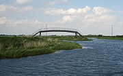
One of the last acts of the Humberside
county council
was to build a new footpath bridge over the West Beck. The bridge is a fixed structure, but has a good headroom. A mistake in the location of the bridge, however, means that it lands on private property, and is dangerously close to the river. Since no more money is available the bridge has remained closed since its construction.
Hamlet (place)
A hamlet is usually a rural settlement which is too small to be considered a village, though sometimes the word is used for a different sort of community. Historically, when a hamlet became large enough to justify building a church, it was then classified as a village...
on the North Frodingham Carrs in the East Riding of Yorkshire
East Riding of Yorkshire
The East Riding of Yorkshire, or simply East Yorkshire, is a local government district with unitary authority status, and a ceremonial county of England. For ceremonial purposes the county also includes the city of Kingston upon Hull, which is a separate unitary authority...
, England
England
England is a country that is part of the United Kingdom. It shares land borders with Scotland to the north and Wales to the west; the Irish Sea is to the north west, the Celtic Sea to the south west, with the North Sea to the east and the English Channel to the south separating it from continental...
. It consists of a couple of farms at the end of a small access road. West Beck
West Beck
West Beck is the common name given to the upper section of the old River Hull, as it rises in the foothills of the Yorkshire Wolds. After reaching Frodingham Beck at Emmotland, it becomes called the River Hull.-Location:...
joins the Driffield Navigation
Driffield Navigation
The Driffield Navigation is an waterway, through the heart of the Holderness Plain to the market town of Driffield, East Riding of Yorkshire, England. The northern section of it is a canal, and the southern section is part of the River Hull. Construction was authorised in 1767, and it was fully...
here.
It forms part of the civil parish of North Frodingham
North Frodingham
North Frodingham is a village and civil parish in the East Riding of Yorkshire, England. It is situated approximately south east of the town of Driffield and lies on the B1249 road....
.
Location
Hempholme
Hempholme is a hamlet in the East Riding of Yorkshire, England, in an area known as Holderness. It is situated approximately north east of Beverley town centre.It lies east of the Driffield Navigation.-Governance:...
, and 1.4 miles (2.3 km) south-west of North Frodingham
North Frodingham
North Frodingham is a village and civil parish in the East Riding of Yorkshire, England. It is situated approximately south east of the town of Driffield and lies on the B1249 road....
. It is on the Holderness
Holderness
Holderness is an area of the East Riding of Yorkshire, on the east coast of England. An area of rich agricultural land, Holderness was marshland until it was drained in the Middle Ages. Topographically, Holderness has more in common with the Netherlands than other parts of Yorkshire...
Plain, in the north east of England
England
England is a country that is part of the United Kingdom. It shares land borders with Scotland to the north and Wales to the west; the Irish Sea is to the north west, the Celtic Sea to the south west, with the North Sea to the east and the English Channel to the south separating it from continental...
.
Situated on the Driffield Navigation
- Next place upstream = FisholmeFisholmeFisholme is a small area in the East Riding of Yorkshire, England that is situated between Brigham and Emmotland. The canal section of the Driffield Navigation leaves Frodingham Beck at this point.-Location:...
- Next place downstream = Bethells BridgeBethells BridgeBethells Bridge, a swing bridge on the Driffield Navigation in the East Riding of Yorkshire, England. The bridge was built to access land cut off after a new section of canal was made...
- Next place upstream on West BeckWest BeckWest Beck is the common name given to the upper section of the old River Hull, as it rises in the foothills of the Yorkshire Wolds. After reaching Frodingham Beck at Emmotland, it becomes called the River Hull.-Location:...
= Corpslanding
History
When the Driffield NavigationDriffield Navigation
The Driffield Navigation is an waterway, through the heart of the Holderness Plain to the market town of Driffield, East Riding of Yorkshire, England. The northern section of it is a canal, and the southern section is part of the River Hull. Construction was authorised in 1767, and it was fully...
was built, a towpath
Towpath
A towpath is a road or trail on the bank of a river, canal, or other inland waterway. The purpose of a towpath is to allow a land vehicle, beasts of burden, or a team of human pullers to tow a boat, often a barge...
bridge was placed over the West Beck near the junction. This bridge disappeared well before 1980.
One of the last acts of the Humberside
Humberside
Humberside was a non-metropolitan and ceremonial county in Northern England from 1 April 1974 until 1 April 1996. It was composed of land from either side of the Humber Estuary, created from portions of the East and West ridings of Yorkshire and parts of Lindsey, Lincolnshire...
county council
County council
A county council is the elected administrative body governing an area known as a county. This term has slightly different meanings in different countries.-United Kingdom:...
was to build a new footpath bridge over the West Beck. The bridge is a fixed structure, but has a good headroom. A mistake in the location of the bridge, however, means that it lands on private property, and is dangerously close to the river. Since no more money is available the bridge has remained closed since its construction.