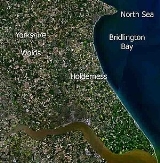
All Topics  
Holderness

 
Holderness

   Email Print
   Bookmark   Link


Holderness


Holderness is an area of the East Riding of Yorkshire
East Riding of Yorkshire

The East Riding of Yorkshire, or simply East Yorkshire is a non-metropolitan district with unitary authority status, and is a ceremonial counties of England of England....
, on the east coast of England
England

native_name =|conventional_long_name = England|common_name = England|image_flag = Flag of England.svg|image_coat = England COA.svg|symbol_type = Royal Coat of Arms...
. An area of rich agricultural land, Holderness was marshland until it was drained in the Middle Ages. Topographically, Holderness has more in common with The Netherlands than other parts of Yorkshire. To the north and west are the Yorkshire Wolds
Yorkshire Wolds

The Yorkshire Wolds are low hills in the Counties of East Riding of Yorkshire and North Yorkshire in North-Eastern England. The name also applies to the district in which the hills lie....
.

From 1974 to 1996 Holderness lay within the borough of Holderness
Holderness (borough)

Holderness was a Districts of England and borough in northern England, named for the Holderness peninsula.It was formed on 1 April, 1974 along with the non-metropolitan county of Humberside in which it was situated....
 in Humberside
Humberside

Humberside was a non-metropolitan county of England from 1 April 1974 until 1 April 1996. It was composed of two halves either side of the Humber estuary, created using part of the East Riding of Yorkshire and West Riding of Yorkshires of Yorkshire and Lindsey....
. Holderness was the name of an ancient administrative area called a wapentake until the nineteenth century, when its functions were replaced by other local government bodies, particularly after the 1875 Local Government Act.


Discussion
Ask a question about 'Holderness'
Start a new discussion about 'Holderness'
Answer questions from other users
Full Discussion Forum


Encyclopedia


Holderness is an area of the East Riding of Yorkshire
East Riding of Yorkshire

The East Riding of Yorkshire, or simply East Yorkshire is a non-metropolitan district with unitary authority status, and is a ceremonial counties of England of England....
, on the east coast of England
England

native_name =|conventional_long_name = England|common_name = England|image_flag = Flag of England.svg|image_coat = England COA.svg|symbol_type = Royal Coat of Arms...
. An area of rich agricultural land, Holderness was marshland until it was drained in the Middle Ages. Topographically, Holderness has more in common with The Netherlands than other parts of Yorkshire. To the north and west are the Yorkshire Wolds
Yorkshire Wolds

The Yorkshire Wolds are low hills in the Counties of East Riding of Yorkshire and North Yorkshire in North-Eastern England. The name also applies to the district in which the hills lie....
.

From 1974 to 1996 Holderness lay within the borough of Holderness
Holderness (borough)

Holderness was a Districts of England and borough in northern England, named for the Holderness peninsula.It was formed on 1 April, 1974 along with the non-metropolitan county of Humberside in which it was situated....
 in Humberside
Humberside

Humberside was a non-metropolitan county of England from 1 April 1974 until 1 April 1996. It was composed of two halves either side of the Humber estuary, created using part of the East Riding of Yorkshire and West Riding of Yorkshires of Yorkshire and Lindsey....
. Holderness was the name of an ancient administrative area called a wapentake until the nineteenth century, when its functions were replaced by other local government bodies, particularly after the 1875 Local Government Act. The city of Kingston upon Hull
Kingston upon Hull

Kingston upon Hull , almost invariably referred to as Hull, is a City status in the United Kingdom and unitary authority area in the East Riding of Yorkshire, England....
 lies in the south west corner of Holderness and Bridlington
Bridlington

Bridlington is a town and civil parish in the East Riding of Yorkshire, England. It has a population of over 33,000 and is twinned with Millau, France and Bad Salzuflen, Germany....
 borders the north-east but both are usually considered separately. The main towns include Beverley
Beverley

Beverley is a market town, civil parish and the county town of the East Riding of Yorkshire, England, located between the River Hull and the Westwood....
, Withernsea
Withernsea

Withernsea is a seaside resort town and civil parish in the East Riding of Yorkshire, England, and forms the focal point for a wider community of small villages in Holderness....
, Hornsea
Hornsea

Hornsea is a small seaside resort town and civil parish in the East Riding of Yorkshire, England at the eastern end of the Trans Pennine Trail. According to the United Kingdom Census 2001 Hornsea parish had a population of 8,243....
 and Hedon
Hedon

Hedon is a small town and civil parish in Holderness in the East Riding of Yorkshire, England. It is situated approximately east of Kingston upon Hull city centre....
.

Location and transport

The area has boundaries which are clearly defined by the rising land of the Yorkshire Wolds
Yorkshire Wolds

The Yorkshire Wolds are low hills in the Counties of East Riding of Yorkshire and North Yorkshire in North-Eastern England. The name also applies to the district in which the hills lie....
 to the north and west, the North Sea
North Sea

The North Sea is a marginal sea, epeiric sea on the European continental shelf. The Dover Strait and the English Channel in the south and the Norwegian Sea in the north connect it to the Atlantic Ocean....
 to the east and the Humber Estuary
Humber

The Humber is a large tidal estuary on the east coast of northern England.The Humber is an estuary formed at Trent Falls, Faxfleet, by the confluence of the tidal River Ouse, Yorkshire and the tidal River Trent....
 to the south.

There are no motorway
Motorway

Motorway is a term for both a type of road and a classification or designation. Motorways are high capacity roads designed to carry fast motor traffic safely....
s in the area, however there is access to the national motorway network via the A63
A63 road

The A63 is a major road in Yorkshire, England between Leeds and Kingston upon Hull ....
 from Hull
Kingston upon Hull

Kingston upon Hull , almost invariably referred to as Hull, is a City status in the United Kingdom and unitary authority area in the East Riding of Yorkshire, England....
. Links to the continent are also via Hull, from where daily ferry services to Rotterdam
Rotterdam

Rotterdam ; city and municipality in the Netherlands province of South Holland, situated in the west of the Netherlands. The municipality is the List of cities in the Netherlands with over 100,000 people in the country, with a population of 584,046 on 1 January 2007 and comprises the southern part of the Randstad, the List of metropolitan are...
 and Zeebrugge
Zeebrugge

Zeebrugge is a village on the coast of Belgium and a subdivision of Bruges, for which it is the modern port. Zeebrugge serves as both the international Port of Bruges-Zeebrugge and a seafront resort with hotels, caf?s and beach....
 depart. A-class roads centre upon Hull and the coastal resort of Bridlington. Otherwise the A1033 road which connects Withernsea
Withernsea

Withernsea is a seaside resort town and civil parish in the East Riding of Yorkshire, England, and forms the focal point for a wider community of small villages in Holderness....
 on the south-east coast to inland areas is the only main route in the area.

The only remaining rail link is the Yorkshire Coast Line
Yorkshire Coast Line

The Yorkshire Coast Line is a railway line in northern England. It runs northwards from Hull Paragon railway station to Bridlington railway station and Scarborough railway station calling at other intermediate stations....
 that runs between Hull in the south and Bridlington and it tends to skirt the area towards the west. Until the 1960s there were lines from Hull
Hull Paragon railway station

Hull Paragon Interchange is a major transportation complex in the city of Kingston upon Hull , England. This incorporates the city's railway station, which is operated by First TransPennine Express, who provide train services along with Northern Rail, First Hull Trains and National Express East Coast....
 to both Hornsea
Hornsea Town railway station

Hornsea Town railway station was the terminus of the Hull and Hornsea Railway, and served the seaside town of Hornsea in the East Riding of Yorkshire, England....
 and Withernsea
Withernsea railway station

Withernsea railway station is a disused railway station that was the terminus of the North Eastern Railway 's Hull and Holderness Railway in Withernsea, East Riding of Yorkshire, England....
, but these were closed as a result of the Beeching Report. Furthermore, in 1901 there was a proposal to construct the North Holderness Light Railway
North Holderness Light Railway

|}The North Holderness Light Railway was a proposed light railway, which was to have been constructed between Beverley and North Frodingham, in The East Riding of Yorkshire....
 from Beverley
Beverley railway station

Beverley railway station serves the town of Beverley in the East Riding of Yorkshire, England. It is located on the Yorkshire Coast Line and is operated by Northern Rail who provide all passenger train services....
 to North Frodingham railway station
North Frodingham railway station

North Frodingham railway station was to have been a station on the proposed North Holderness Light Railway, serving the village of North Frodingham in The East Riding of Yorkshire....
, but this came to nothing.

Physical geography


Climate

As part of the United Kingdom
United Kingdom

The United Kingdom of Great Britain and Northern Ireland, commonly known as the United Kingdom , the UK or Britain,is a sovereign state located off the northwestern coast of continental Europe....
, the Holderness area generally has cool summers and relatively mild winters. Weather conditions vary from day to day as well as from season to season. The latitude of the area means that it is influenced by predominantly westerly winds with depressions and their associated fronts, bringing with them unsettled and windy weather, particularly in winter. Between depressions there are often small mobile anticyclone
Anticyclone

In meteorology, an anticyclone is a weather meteorological phenomenon in which there is a descending movement of the air and a high pressure area over the part of the planet's surface affected by it....
s that bring periods of fair weather. In winter anticyclones bring cold dry weather. In summer the anticyclones tend to bring dry settled conditions which can lead to drought. For its latitude this area is mild in winter and cooler in summer due to the influence of the Gulf Stream
Gulf Stream

The Gulf Stream, together with its northern extension towards Europe, the North Atlantic Current, is a powerful, warm, and swift Atlantic Ocean ocean current that originates in the Gulf of Mexico, exits through the Straits of Florida, and follows the eastern coastlines of the United States and Newfoundland and Labrador before crossing the At...
 in the northern Atlantic Ocean
Atlantic Ocean

The Atlantic Ocean is the second-largest of the world's oceanic divisions; with a total area of about 106.4 million square kilometres . It covers approximately one-fifth of the Earth's surface....
. Air temperature varies on a daily and seasonal basis. The temperature is usually lower at night and January is the coldest time of the year. The two dominant influences on the climate of the Holderness are the shelter against the worst of the moist westerly winds provided firstly by the Pennines
Pennines

The Pennines are a low-rising mountain range in northern England and southern Scotland. They separate the North West England from Yorkshire and the North East England....
 and then the Yorkshire Wolds
Yorkshire Wolds

The Yorkshire Wolds are low hills in the Counties of East Riding of Yorkshire and North Yorkshire in North-Eastern England. The name also applies to the district in which the hills lie....
 and the proximity of the North Sea. Generally, rainfall is 600 to 700 mm per year which is low compared with the national average rainfall of 1125 mm.

Geology and topography


Geologically, Holderness is underlain by Cretaceous
Cretaceous

The Cretaceous , usually abbreviated K for its German translation Kreide, is a geologic period from circa to million years ago . In the geologic timescale, the Cretaceous follows on the Jurassic period and is followed by the Paleogene period....
 Chalk but in most places it is so deeply buried beneath glacial deposits that it has no influence on the landscape. The landscape is dominated by deposits of till, boulder clays and glacial lake clays. These were deposited during the Devensian glaciation. The glacial deposits form a more or less continuous lowland plain which has some peat filled depressions (known locally as meres) which mark the presence of former lake beds. There are other glacial landscape features such as drumlin
Drumlin

A drumlin is an elongated whale-shaped hill formed by glacier action. Its long axis is parallel with the movement of the ice, with the blunter end facing into the glacial movement....
 mounds, ridges and kettle holes scattered throughout the area.

The well drained glacial deposits provide fertile soils that can support intensive arable cultivation. Fields are generally large and bounded by drainage ditches. There is very little woodland in the area and this leads to a landscape that is essentially rural but very flat and exposed. The coast is subject to rapid marine erosion.

Erosion


The Holderness coastline suffers the highest rate of coastal erosion
Coastal erosion

Coastal erosion is the wearing away of land or the removal of beach or dune sediments by wave action, Tide, wave currents, or drainage . Waves, generated by storms, wind, or fast moving motor craft, cause coastal erosion, which may take the form of long-term losses of sediment and Rock , or merely the temporary redistribution of coastal sed...
 in Europe: 5 feet (1.5 m) a year on average or 2 million tonnes of material a year. Some of this is transported by longshore drift
Longshore drift

Longshore drift is a geology process by which sediments such as sand or other materials, move along a beach shore. It uses the process of swash to push the material up the beach and backwash down the beach; until it reaches a groyne or another obstacle....
 with about 3% of material being deposited at Spurn
Spurn

Spurn Point is a narrow sand spit on the tip of the coast of the East Riding of Yorkshire, England that reaches into the North Sea and forms the north bank of the mouth of the Humber estuary....
 Head spit, to the south. The growth of Spurn Head is demonstrated by a series of lighthouses that have been built on the point. It is thought that approximately 3 miles (5 km) of land has been lost since the Roman era
Roman era

The Roman Era is a period in Western history, when Ancient Rome was the centre of power of the world around the Mediterranean Sea, where Latin was the lingua franca....
, including at least 23 towns/villages, including for example Ravenspurn
Ravenspurn

Ravenspurn was an old East Riding of Yorkshire town, in England, which was lost due to coastal erosion. The town is one of more than 30 along the Holderness Coast which have been lost to the North Sea since the 1800s....
. The Holderness coastline is susceptible to erosion due to the long north-easterly fetch, allowing for powerful waves, and the softness of the geology that make up the cliffs. Holderness is also a former bay that was filled in during the last ice age
Ice age

The general term "ice age" or, more precisely, "glacial age" denotes a geological period of long-term reduction in the temperature of the Earth's surface and atmosphere, resulting in an expansion of continental ice sheets, polar ice sheets and alpine glaciers....
 and is now made up of chalk/glacial
Till

Till is unsorted glacier sediment. Glacial drift is a general term for the coarsely graded and extremely heterogeneous sediments of glacial origin....
 compounds that are easily eroded such as boulder clay.

All the villages affected by the erosion are located on the north side of the estuary of the River Humber. The area stretches from Flamborough Head (high chalk cliffs, just north of Bridlington) down to Spurn Head (sand spit, on above map). Villages such as Ravenser, which sent representatives to the parliament of Edward I
Edward I of England

Edward I , popularly known as Longshanks, the English Justinian, and the Hammer of the Scots , was a House of Plantagenet King of England who achieved historical fame by conquering large parts of Wales and almost succeeding in doing the same to Scotland....
, have totally disappeared. Holderness has lost about 5 kilometers since Roman times.

The local authorities are endeavouring to prevent the effects of erosion. Hard defences
Coastal management

In some jurisdictions the terms sea defense and coastal protection are used to mean, respectively, defence against flooding and erosion....
 in the form of a concrete seawall and timber groynes have given some protection. It has been suggested that a large underwater reef made of tyres could be built off the Holderness coast to mitigate this erosion but it would be costly to build. Other defences include sea walls, groynes, and gabions but business people say that if the erosion is not stopped then there will be millions of pounds of damage. However, one or more such groynes has had a detrimental effect further along the coast, in some areas resulting in erosion of up to twenty metres per year.

Drainage

The Holderness area is drained by the River Hull and its tributaries and a number of coastal streams. The valley of the River Hull is broad and shallow and in its lower reaches the river is contained within flood banks. The River Hull Tidal Surge Barrier at the mouth of the river can be used to prevent surge tides overwhelming the flood defences. Large areas of Holderness are too flat and low to drain naturally so in these areas a low level drainage system operates to collect the water. In the middle and lower reaches of the River Hull water is pumped from the low level drains into a high level system. This system consists of elevated water courses bounded by embankments. It drains by gravity into the sea.

In the east and south-east of Holderness there is a complex network of drains and streams that flow south into the Humber or east into the North Sea. To mitigate the effects of high tides stopping the water flow from these outlets, several have had pumping stations constructed at their outfalls.

Natural history

For the purpose of describing the natural history the area can be divided into three parts:-

  • The Valley of the River Hull
The River Hull valley dominates the western landscape of Holderness. The river and its associated wetland habitats support a diverse range of plants and animals. The upper tributaries of the river originate on the edge of the Yorkshire Wolds before entering the area of glacial and alluvial deposits of Holderness. The river bed varies in composition reflecting the underlying geology. In the upper reaches of the river water crowfoot, lesser water parsnip, mares tail and spiked water milfoil may be found in the main channel whilst the marginal vegetation is composed of branched bur-reed, common reed and reed sweetgrass.

Otters have recently recolonised the upper reaches of the river, however the water vole is now confined to a few isolated populations. Notable species of invertebrates include uncommon mayflies. There is a diverse breeding bird community including lapwing, snipe and redshank. Wildfowl such as mallard and mute swans may also be seen, along with yellow wagtail, sedge warbler, reed warbler and reed bunting.

Further south towards Beverley and Hull the river becomes tidal and saline. In the lower reaches it is enclosed by flood banks with little associated natural habitat remaining. The majority of the formerly extensive wetlands have been subject to drainage schemes and agricultural improvement. However some small remnants remain along the Hull valley between Driffield and Wansford. Plants that are typical of these habitats including a variety of reeds, rushes and sedges as well as yellow flag, valerian and meadowsweet may be found.

There are few surviving areas of woodland among the open farmland which supports golden plover and lapwing and a flora of arable weeds.

  • The Coast


The coast from Bridlington in the north to Spurn Point is an interesting complex of coastal processes. The soft cliffs of Holderness are subject to rapid erosion whilst the eroded material is being deposited on the Spurn Peninsula. The speed of erosion along the glacial till cliffs prohibits colonisation of anything but sparse ruderal vegetation. Coltsfoot is particularly common and sand martin colonies have become established in places.

Hornsea Mere
Hornsea Mere

Hornsea Mere is generally described as the largest natural freshwater lake in Yorkshireand lies to the west of Hornsea in the East Riding of Yorkshire....
 is the largest natural lake in Yorkshire at 120 hectares. It has, besides the open fresh water habitat, marginal habitats of reed swamp, species-rich fen and carr woodland. It regularly supports populations of wintering wildfowl and the reed beds provide breeding sites for reed warblers. Characteristic plants include milk parsley, greater water parsnip and lesser reedmace.

  • The Humber Estuary
The intertidal system of the estuary of the River Humber has local seagrass beds that provide feeding and wintering areas for over 133,000 waders and wildfowl. It is rich in invertebrate communities. The estuary also provides for breeding birds, grey seals and natterjack toad
Natterjack Toad

The Natterjack Toad is a toad native to sandy and heath areas of Northern Europe. Adults are 60 - 70 mm in length and are distinguished from the common toad by a yellow line down the middle of the back....
s.

Spurn Point at the tip of the Spurn Peninsula is made of hard glacial moraine so is less liable to erosion than areas further north on the Holderness coast. The Spurn Peninsula is a beach with dunes which moves in response to the action of the waves. The wave action removes sand from the east of the beach and deposits it on the western side. The coast is influenced mainly by wave action but in the estuary the processes are driven by the power of the tides. The incoming tidal currents carry more sediment into the estuary than the ebb tides carry out. The estuary is shallow because of this constant deposition. Isostatic recoil is, however, causing the area to sink at the rate of 3 mm annually and global warming is making the sea level rise. The combined effects of these processes mean that the sea in the estuary may be half a metre higher by the year 2050. A large area around the estuary consists of land which lies below the present high water mark. Flood defences offer only a short term and local answer and may actually increase the long term risks. Managed realignment of the coast by setting back the coastal defences will provide new intertidal habitats and harness natural equalising processes and is the preferred long term solution.

History


Prehistory

There is archaeological evidence to suggest that the first settlers in Holderness arrived in the Neolithic era when the plain was still very wet and most likely consisted of a mixture of marshes, lakes, islands and woodland. As the sea level changed and the area became drier it was progressively cleared of trees and the higher drier parts were initially favoured for settlement.

Anglo-Saxon

The Domesday survey reveals that in the reign of Edward the Confessor there were 45 different freeholders having land in Holderness. The name of Holderness may be derived from the Danish “hold” which was the name given in that language to a nobleman with considerable territorial possessions. The "ness" part generally refers to a prominentary, or nose-shape, either in a river or jutting from a coastline.

Medieval

After the Norman Conquest of England the extensive Lordship of Holderness was given by King William I of England to Drogo de la Beuvirere, a Flemish supporter. This Drogo built a castle at Skipsea before 1087 when his estates were confiscated by the king.

The area was then given to Odo, Count of Champaigne, but was taken from him when he rebelled against the King William II in 1095. It was returned to his son Stephen of Aumale
Stephen of Aumale

Stephen of Aumale was Count of Aumale from 1082 to 1127.He was son of Eudes de Blois, Count of Troyes and Count of Meaux, and Adelaide of Normandy, countess of Aumale, and sister of William the Conqueror....
 in 1102.

Large estates in Holderness were held by the Bishop of Durham and the Archbishop of York. Other large landowners in the area included the abbeys of Meaux and Thornton and the priories of Swine, Nunkeeling and Bridlington. This land was confiscated and became crown property when Henry VIII of England dissolved the monasteries in the 16th century.

Tudor and Stuart

The Aumale lordship had also passed to the crown and was obtained along with some former monastic lands by the Constable family of Burton Constable
Burton Constable

Burton Constable is a village and civil parish in the East Riding of Yorkshire, England. It is located approximately north east of Kingston upon Hull city centre and south east of the village of Skirlaugh....
 in the 16th century. Other large estates created from former monastic holdings were sold by the crown to private landowners in the 17th and 18th centuries. Piecemeal attempts were made to improve the poor drainage of the area and with the formation of drainage boards in the later 18th century flooding began to be controlled. The remaining wastes were added to farm land and the meres, fluctuating lakes, disappeared.

19th and 20th centuries

The opening of a railway from Hull accelerated the growth of Hornsea as a coastal resort and seaside suburb of Hull. Many of the other settlements grew and changed their character from agricultural villages to become dormitory settlements
Commuter town

A commuter town is an urban community that is primarily residential, from which most of the workforce commuting out to earn their livelihood. Many commuter towns act as Suburb of a nearby metropolis that workers travel to daily, and many suburbs are commuter towns....
 of Hull, Beverley, Bridlington and Driffield. Sales of large landed estates have reduced many of the large agricultural holdings that were in private ownership but some still remain and some have been used to create large farming agri-businesses which manage considerable areas with few farms. The rail link to Hornsea closed in 1965.

Demography

Administratively and politically the Holderness area now lies within a number of different divisions. The Beverley and Holderness parliamentary constituency statistics have been used to provide a representative picture of the area.

In 2004 there were 95,077 people living in the area in 41,224 households. Of these people 4.7% were aged below 25 years, 52.6% were aged between 25 and 55 years and 42.8% were 55 years old or more. The population density was in 2001 was 1.25 persons per hectare and 78% of households were privately owned compared with a national average of 68%.

There was a relatively low unemployment rate of 1.7% compared with a national average of 2.3 %.

Economy

In Holderness the average household income in 2004 was £27,958 compared with a national average of £30,081. The area provides adequate shopping and market facilities for its residents and visitors. The three small towns of Hedon, Hornsea and Withernsea offer a range of facilities and the larger local centres of Bridlington and Beverley are regularly used by Holderness people. Hull is the largest commercial centre which is regularly used and it provides employment for a significant proportion of the population.

Agriculture is the traditional employment of the area and there is a substantial area of horticultural development on the flat fertile land in the south-west. Animal husbandry, particularly pig rearing, is a major part of the agricultural scene. In 2001 agriculture employed 4.5% of the working population.

Industrial activity ranges from small workshop units in Hornsea and Withernsea to the Easington and Dimlington gas terminals on the east coast. These terminals process gas from the North Sea gas fields. The British Petroleum chemical works at Saltend
Salt End

Salt End or Saltend is a Hamlet in the East Riding of Yorkshire, England, in an area known as Holderness. It is situated on the north bank of the Humber just outside the Kingston upon Hull eastern boundary on the A1033 road....
 uses condensates from the gas refining process and is a major employer in the area.

Tourism makes a significant contribution to the economy of Hornsea and Withernsea with Hornsea Pottery and Freeport attracting around a million visitors each year.

Fiction

"The Priory School" a Sherlock Holmes mystery by Sir Arthur Conan Doyle takes place mostly in Holderness. Also one of the main characters is the Duke of Holderness who resides in the area at the fictional Holderness Hall.

Also, the Summoner's Tale in Chaucer's The Canterbury Tales takes place in Holderness, described as "a mersshy contree."