
Red River Valley Tornado Outbreak
Encyclopedia
The 1979 Red River Valley tornado outbreak was a tornado
event that occurred on April 10, 1979 near the Red River Valley
. It's most noted for the F4 tornado that hit Wichita Falls, Texas
and is commonly referred to as "Terrible Tuesday" by many meteorologists. Additional tornadoes were reported across the Southern Plains as well as in the Mississippi River Valley on April 10-April 11, 1979.
as a warm front
lifted north pulling warm, moist, unstable air. There was strong upper level dynamics all coming together to produce strong tornado-producing supercells. In the early afternoon hours, three supercell thunderstorms formed. They moved northeastward, and as a trio spawned families of tornadoes. These supercells caused the most damaging tornadoes of the outbreak.
The first tornado formed near Crowell, Texas
at around 3:05 P.M. About 35 minutes later, the tornado ripped through Vernon
and killed 11 people. Then the tornado killed three people in Lawton, Oklahoma
. The second supercell spawned a tornado that moved 64 miles (103 km).
and Wichita Falls
. The supercell formed a family of three tornadoes. The first formed near Seymour at around 4:53 P.M.. The storm spawned a second tornado and moved through the south and east sides of Wichita Falls at around 6:00 P.M. The storm spawned another tornado near Waurika, Oklahoma
at around 8:00 P.M.
The storm formed in Archer County, Texas
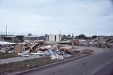
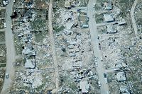
and moved northeast and damaged a few rural homes and high voltage towers. The three tornadoes met and touched down just south of Memorial Stadium by McNiel Jr. High on Southwest Parkway, which was located to the west of Wichita Falls at approximately 6:07 damaging both structures severely. Hail the size of golf balls preceded the touchdown and continued for approximately 15 minutes. It then became calm before the winds began to pick up. The three cells joined together about 1/4 of the length of the funnels because they were very close to the ground and as they ripped through Wichita Falls, they cut a 2.5-mile swath of destruction. The tornado destroyed an apartment complex across the street. The tornado also took its first lives at the complex. The tornado later destroyed a restaurant, the majority of Sikes Senter, the major mall in the town, and another apartment complex where the tornado took more lives. Neighborhoods all along Southwest Parkway were leveled and nothing but debris and destruction remained (Recounted by J.M. Mauldwin - resident).
A number of people tried to flee as the tornado moved along US Highways 281 and 287. More people were killed in their cars. The tornado then moved into Clay County
and changed its appearance. There were five satellite tornadoes spinning around the parent tornado. It did more damage south of Dean and Byers, TX, but no more fatalities.
. The Wichita Falls tornado alone killed 42 people. The tornado caused $400 million in damage. An 8 miles (13 km) swath of the city had significant devastation.
Dr. Ted Fujita, who was working at the University of Chicago
, said the tornado caused as much as F5
damage on the east and south sides of the city.
Tornado
A tornado is a violent, dangerous, rotating column of air that is in contact with both the surface of the earth and a cumulonimbus cloud or, in rare cases, the base of a cumulus cloud. They are often referred to as a twister or a cyclone, although the word cyclone is used in meteorology in a wider...
event that occurred on April 10, 1979 near the Red River Valley
Red River (Mississippi watershed)
The Red River, or sometimes the Red River of the South, is a major tributary of the Mississippi and Atchafalaya Rivers in the southern United States of America. The river gains its name from the red-bed country of its watershed. It is one of several rivers with that name...
. It's most noted for the F4 tornado that hit Wichita Falls, Texas
Wichita Falls, Texas
Wichita Falls is a city in and the county seat of Wichita County, Texas, United States, United States. Wichita Falls is the principal city of the Wichita Falls Metropolitan Statistical Area, which encompasses all of Archer, Clay and Wichita counties. According to the U.S. Census estimate of 2010,...
and is commonly referred to as "Terrible Tuesday" by many meteorologists. Additional tornadoes were reported across the Southern Plains as well as in the Mississippi River Valley on April 10-April 11, 1979.
Formation of the tornadoes
A deepening low pressure system formed in ColoradoColorado
Colorado is a U.S. state that encompasses much of the Rocky Mountains as well as the northeastern portion of the Colorado Plateau and the western edge of the Great Plains...
as a warm front
Warm front
A warm front is a density discontinuity located at the leading edge of a homogeneous warm air mass, and is typically located on the equator-facing edge of an isotherm gradient...
lifted north pulling warm, moist, unstable air. There was strong upper level dynamics all coming together to produce strong tornado-producing supercells. In the early afternoon hours, three supercell thunderstorms formed. They moved northeastward, and as a trio spawned families of tornadoes. These supercells caused the most damaging tornadoes of the outbreak.
The first tornado formed near Crowell, Texas
Crowell, Texas
Crowell is a city in Foard County, Texas, United States. It serves as the county seat, and the population was 1,141 at the 2000 census.-Geography:Crowell is located at ....
at around 3:05 P.M. About 35 minutes later, the tornado ripped through Vernon
Vernon, Texas
Vernon is a city in Wilbarger County, Texas, United States. As of the 2000 census, the population was 11,660; it was 11,077 in the 2005 census estimate. Vernon is the county seat of Wilbarger County....
and killed 11 people. Then the tornado killed three people in Lawton, Oklahoma
Lawton, Oklahoma
The city of Lawton is the county seat of Comanche County, in the U.S. state of Oklahoma. Located in the southwestern region of Oklahoma approximately southwest of Oklahoma City, it is the principal city of the Lawton Oklahoma Metropolitan Statistical Area...
. The second supercell spawned a tornado that moved 64 miles (103 km).
Wichita Falls
The third supercell was the one that formed the tornado that moved through Seymour, TexasSeymour, Texas
Seymour is a city in and the county seat of Baylor County, Texas, United States. The population was 2,740 as of the 2010 Census.-Geography:Seymour is located at ....
and Wichita Falls
Wichita Falls, Texas
Wichita Falls is a city in and the county seat of Wichita County, Texas, United States, United States. Wichita Falls is the principal city of the Wichita Falls Metropolitan Statistical Area, which encompasses all of Archer, Clay and Wichita counties. According to the U.S. Census estimate of 2010,...
. The supercell formed a family of three tornadoes. The first formed near Seymour at around 4:53 P.M.. The storm spawned a second tornado and moved through the south and east sides of Wichita Falls at around 6:00 P.M. The storm spawned another tornado near Waurika, Oklahoma
Waurika, Oklahoma
Waurika is a city in Jefferson County, Oklahoma, United States. The population was 1,988 at the 2000 census. It is the county seat of Jefferson County. The name is the Comanche compound 'worm eater' from woa 'worm' + 'eat' and presumably refers to a group of Comanche living in the area or to...
at around 8:00 P.M.
The storm formed in Archer County, Texas
Archer County, Texas
Archer County is a county located in the US state of Texas, and was formed in 1858 from Fannin County. It is part of the Wichita Falls, Texas, Metropolitan Statistical Area. As of 2005, the population estimate is 9,095, up from 8,854 in 2000. Its county seat is Archer City. Archer is named for...
and moved northeast and damaged a few rural homes and high voltage towers. The three tornadoes met and touched down just south of Memorial Stadium by McNiel Jr. High on Southwest Parkway, which was located to the west of Wichita Falls at approximately 6:07 damaging both structures severely. Hail the size of golf balls preceded the touchdown and continued for approximately 15 minutes. It then became calm before the winds began to pick up. The three cells joined together about 1/4 of the length of the funnels because they were very close to the ground and as they ripped through Wichita Falls, they cut a 2.5-mile swath of destruction. The tornado destroyed an apartment complex across the street. The tornado also took its first lives at the complex. The tornado later destroyed a restaurant, the majority of Sikes Senter, the major mall in the town, and another apartment complex where the tornado took more lives. Neighborhoods all along Southwest Parkway were leveled and nothing but debris and destruction remained (Recounted by J.M. Mauldwin - resident).
A number of people tried to flee as the tornado moved along US Highways 281 and 287. More people were killed in their cars. The tornado then moved into Clay County
Clay County, Texas
As of the census of 2000, there were 11,006 people, 4,323 households, and 3,181 families residing in the county. The population density was 10 people per square mile . There were 4,992 housing units at an average density of 4 per square mile...
and changed its appearance. There were five satellite tornadoes spinning around the parent tornado. It did more damage south of Dean and Byers, TX, but no more fatalities.
Damage
At the end of the outbreak, 54 people lost their lives in Texas, three were killed in Oklahoma and one was killed in IndianaIndiana
Indiana is a US state, admitted to the United States as the 19th on December 11, 1816. It is located in the Midwestern United States and Great Lakes Region. With 6,483,802 residents, the state is ranked 15th in population and 16th in population density. Indiana is ranked 38th in land area and is...
. The Wichita Falls tornado alone killed 42 people. The tornado caused $400 million in damage. An 8 miles (13 km) swath of the city had significant devastation.
Dr. Ted Fujita, who was working at the University of Chicago
University of Chicago
The University of Chicago is a private research university in Chicago, Illinois, USA. It was founded by the American Baptist Education Society with a donation from oil magnate and philanthropist John D. Rockefeller and incorporated in 1890...
, said the tornado caused as much as F5
Fujita scale
The Fujita scale , or Fujita-Pearson scale, is a scale for rating tornado intensity, based primarily on the damage tornadoes inflict on human-built structures and vegetation...
damage on the east and south sides of the city.
April 10, 1979 tornado event
| F# Fujita scale The Fujita scale , or Fujita-Pearson scale, is a scale for rating tornado intensity, based primarily on the damage tornadoes inflict on human-built structures and vegetation... |
Location | County | Time (UTC) | Path length | Damage | |
|---|---|---|---|---|---|---|
| Texas Texas Texas is the second largest U.S. state by both area and population, and the largest state by area in the contiguous United States.The name, based on the Caddo word "Tejas" meaning "friends" or "allies", was applied by the Spanish to the Caddo themselves and to the region of their settlement in... |
||||||
| F0 | S of Crosbyton Crosbyton, Texas Crosbyton is a city in and the county seat of Crosby County, Texas, United States. The population was 1,874 at the 2000 census. Crosbyton is part of the Lubbock Metropolitan Statistical Area.... |
Crosby | 1908 | 2 miles (3.2 km) |
||
| F0 | E of Plainview Plainview, Texas Plainview is a city in and the county seat of Hale County, Texas, United States. The population was 22,336 at the 2000 census.-Geography:Plainview is located at .... |
Hale Hale County, Texas Hale County is a county located in the U.S. state of Texas. In 2000, its population was 36,602. It was organized in 1888, and is named for Lt. John C. Hale, a hero of the Battle of San Jacinto. The seat of the county is Plainview. It is home of the noted former Hale County Judge, Judge Bill... |
1938 | 0.1 miles (0.16 km) |
||
| F2 | S of Foard City to S of Rayland | Foard Foard County, Texas As of the census of 2000, there were 1,622 people, 664 households, and 438 families residing in the county. The population density was 2 people per square mile . There were 850 housing units at an average density of 1 per square mile... |
2105 | 22.1 miles (35.4 km) |
||
| F4 | SE of Rayland, TX to NE of Davidson, OK Davidson, Oklahoma Davidson is a town in Tillman County, Oklahoma, United States. The population was 315 at the 2010 census. The town experienced a minor flood in 1995.-Geography:Davidson is located at .... |
Foard, TX Foard County, Texas As of the census of 2000, there were 1,622 people, 664 households, and 438 families residing in the county. The population density was 2 people per square mile . There were 850 housing units at an average density of 1 per square mile... , Wilbarger Wilbarger County, Texas *Harrold *Odell *Oklaunion *Vernon-Notable natives and residents:*Jack English Hightower, Memphis, Texas, native; former member of both houses of the Texas State Legislature, and former U.S... , Tillman, OK Tillman County, Oklahoma Tillman County is a county located in the U.S. state of Oklahoma. As of 2000, the population was 9,287. The county seat is Frederick. .-Geography:According to the U.S... |
2120 | 39.7 miles (63.5 km) |
11 deaths | |
| F0 | SE of Thalia Thalia, Texas Thalia is an unincorporated town in Foard County in the northern part of the U.S. state of Texas. As of 1990, the population was 104. Its name was given to the town portrayed in a number of Larry McMurtry's novels, including his first novel, Horseman, Pass By... |
Foard Foard County, Texas As of the census of 2000, there were 1,622 people, 664 households, and 438 families residing in the county. The population density was 2 people per square mile . There were 850 housing units at an average density of 1 per square mile... |
2120 | 2.5 miles (4 km) |
||
| F2 | Harrold, TX Harrold, Texas Harrold is an unincorporated community in eastern Wilbarger County, Texas, United States.The Harrold Independent School District serves area students, including transfers from Electra and Vernon.-External links:... to Marlow, OK Marlow, Oklahoma Marlow is a city in Stephens County, Oklahoma, United States. The population was 4,592 at the 2000 census.-Geography:Marlow is located at .... |
Wilbarger, TX Wilbarger County, Texas *Harrold *Odell *Oklaunion *Vernon-Notable natives and residents:*Jack English Hightower, Memphis, Texas, native; former member of both houses of the Texas State Legislature, and former U.S... , Wichita Wichita County, Texas As of the census of 2000, there were 131,664 people, 48,441 households, and 32,891 families residing in the county. The population density was 210 people per square mile . There were 53,304 housing units at an average density of 85 per square mile... , Tillman, OK Tillman County, Oklahoma Tillman County is a county located in the U.S. state of Oklahoma. As of 2000, the population was 9,287. The county seat is Frederick. .-Geography:According to the U.S... , Cotton Cotton County, Oklahoma Cotton County is a county located in the U.S. state of Oklahoma. As of 2000, the population was 6,614. Its county seat is Walters.When Oklahoma achieved statehood in 1907, the area which is now Cotton County fell within the boundaries of Comanche County... , Comanche Comanche County, Oklahoma Comanche County is a county located in the U.S. state of Oklahoma. Built on former reservation lands of the Comanche, Kiowa, and Apache in Indian Territory, Comanche County was open for settlement on August 16, 1901 by lottery. The region has three cities and seven towns as well as the Fort Sill... , Stephens Stephens County, Oklahoma Stephens County is a county located in the U.S. state of Oklahoma. As of 2000, the population was 43,182. Its county seat is Duncan.-Geography:According to the U.S. Census Bureau, the county has a total area of 2,308 km²... |
2155 | 74.1 miles (118.6 km) |
1 death | |
| F2 | NE of Seymour Seymour, Texas Seymour is a city in and the county seat of Baylor County, Texas, United States. The population was 2,740 as of the 2010 Census.-Geography:Seymour is located at .... |
Baylor Baylor County, Texas As of the census of 2000, there were 4,093 people, 1,791 households, and 1,156 families residing in the county. The population density was 5 people per square mile . There were 2,820 housing units at an average density of 3 per square mile... |
2249 | 10.4 miles (16.6 km) |
||
| F1 | SW of Iowa Park Iowa Park, Texas Iowa Park is a city in Wichita County, Texas, United States. It is part of the Wichita Falls, Texas Metropolitan Statistical Area. The population was 6,431 at the 2000 census.-Geography:Iowa Park is located at .... |
Wichita Wichita County, Texas As of the census of 2000, there were 131,664 people, 48,441 households, and 32,891 families residing in the county. The population density was 210 people per square mile . There were 53,304 housing units at an average density of 85 per square mile... |
2308 | 0.1 miles (0.16 km) |
||
| F4 | SW of Wichita Falls, TX Wichita Falls, Texas Wichita Falls is a city in and the county seat of Wichita County, Texas, United States, United States. Wichita Falls is the principal city of the Wichita Falls Metropolitan Statistical Area, which encompasses all of Archer, Clay and Wichita counties. According to the U.S. Census estimate of 2010,... to E of Waurika, OK Waurika, Oklahoma Waurika is a city in Jefferson County, Oklahoma, United States. The population was 1,988 at the 2000 census. It is the county seat of Jefferson County. The name is the Comanche compound 'worm eater' from woa 'worm' + 'eat' and presumably refers to a group of Comanche living in the area or to... |
Archer, TX Archer County, Texas Archer County is a county located in the US state of Texas, and was formed in 1858 from Fannin County. It is part of the Wichita Falls, Texas, Metropolitan Statistical Area. As of 2005, the population estimate is 9,095, up from 8,854 in 2000. Its county seat is Archer City. Archer is named for... , Wichita, TX Wichita County, Texas As of the census of 2000, there were 131,664 people, 48,441 households, and 32,891 families residing in the county. The population density was 210 people per square mile . There were 53,304 housing units at an average density of 85 per square mile... , Clay Clay County, Texas As of the census of 2000, there were 11,006 people, 4,323 households, and 3,181 families residing in the county. The population density was 10 people per square mile . There were 4,992 housing units at an average density of 4 per square mile... , Jefferson, OK Jefferson County, Oklahoma Jefferson County is a county located in the U.S. state of Oklahoma. As of 2000, the population was 6,818. Its county seat is Waurika.-Geography:... |
2350 | 46.9 miles (75 km) |
42 deaths | |
| F1 | Wichita Falls Wichita Falls, Texas Wichita Falls is a city in and the county seat of Wichita County, Texas, United States, United States. Wichita Falls is the principal city of the Wichita Falls Metropolitan Statistical Area, which encompasses all of Archer, Clay and Wichita counties. According to the U.S. Census estimate of 2010,... area |
Wichita Wichita County, Texas As of the census of 2000, there were 131,664 people, 48,441 households, and 32,891 families residing in the county. The population density was 210 people per square mile . There were 53,304 housing units at an average density of 85 per square mile... |
0000 | 2 miles (3.2 km) |
||
| F2 | SW of Novice Novice, Texas Novice is a city in Coleman County, Texas, United States. The population was 142 at the 2000 census.-Geography:Novice is located at .According to the United States Census Bureau, the city has a total area of , all of it land.... |
Runnels, Coleman | 0317 | 9.6 miles (15.4 km) |
||
| F3 | SW of Talpa Talpa, Texas Talpa is an unincorporated community in Coleman County, Texas, United States. According to the Handbook of Texas, the community had an estimated population of 127 in 2000.-Geography:Talpa is located at . It is situated along U.S... to N of Coleman Coleman, Texas Coleman is a city in Coleman County, Texas, United States. The population was 5,127 at the 2000 census. It is the county seat of Coleman County.-Geography:Coleman is located at .... |
Runnels, Coleman | 0330 | 25 miles (40 km) |
||
| F1 | SE of Comanche Comanche, Texas Comanche is a city located in Comanche County in the U.S. state of Texas. The population was 4,482 at the 2000 census. It is the county seat of Comanche County. The town square has been renovated and is becoming a popular tourist attraction. With "Star Beaus" and "karens" on the square and their... |
Comanche Comanche County, Texas Comanche County is a county located on the Edwards Plateau in Central Texas. In 2000, its population was 14,026. Comanche was founded in 1856. Comanche is named for the Comanche Native American tribe... |
0350 | 0.1 miles (0.16 km) |
||
| F2 | S of Energy Energy, Texas Energy is an unincorporated community located in Comanche County in Central Texas.-External links:* Handbook of Texas Online.... to W of Hico Hico, Texas Hico is a small city located in Hamilton County in Central Texas. The population was 1,341 at the 2000 census. The town motto is "Where Everybody Is Somebody!" The county seat is Hamilton some twenty miles to the south on United States Highway 281.... |
Comanche Comanche County, Texas Comanche County is a county located on the Edwards Plateau in Central Texas. In 2000, its population was 14,026. Comanche was founded in 1856. Comanche is named for the Comanche Native American tribe... , Hamilton |
0350 | 24 miles (38.4 km) |
||
| F1 | Mineral Wells Mineral Wells, Texas Mineral Wells is a city in Palo Pinto and Parker counties in the U.S. state of Texas. The population was 16,946 at the 2000 census. The city is named for mineral springs in the area, which were highly popular in the early 1900s... area |
Palo Pinto Palo Pinto County, Texas As of the census of 2000, there were 27,026 people, 10,594 households, and 7,447 families residing in the county. The population density was 28 people per square mile . There were 14,102 housing units at an average density of 15 per square mile... |
0356 | 0.1 miles (0.16 km) |
||
| Oklahoma Oklahoma Oklahoma is a state located in the South Central region of the United States of America. With an estimated 3,751,351 residents as of the 2010 census and a land area of 68,667 square miles , Oklahoma is the 28th most populous and 20th-largest state... |
||||||
| F2 | N of Hollister Hollister, Oklahoma Hollister is a town in Tillman County, Oklahoma, United States. The population was 50 at the 2010 census.-Geography:Hollister is located at .... |
Tillman Tillman County, Oklahoma Tillman County is a county located in the U.S. state of Oklahoma. As of 2000, the population was 9,287. The county seat is Frederick. .-Geography:According to the U.S... |
2205 | 9.2 miles (14.7 km) |
||
| F1 | N of Faxon Faxon, Oklahoma Faxon is a town in Comanche County, Oklahoma, United States. The population was 136 at the 2010 census. It is included in the Lawton, Oklahoma Metropolitan Statistical Area.-Geography:Faxon is located at .... |
Comanche Comanche County, Oklahoma Comanche County is a county located in the U.S. state of Oklahoma. Built on former reservation lands of the Comanche, Kiowa, and Apache in Indian Territory, Comanche County was open for settlement on August 16, 1901 by lottery. The region has three cities and seven towns as well as the Fort Sill... |
2235 | 7.1 miles (11.4 km) |
||
| F3 | Lawton Lawton, Oklahoma The city of Lawton is the county seat of Comanche County, in the U.S. state of Oklahoma. Located in the southwestern region of Oklahoma approximately southwest of Oklahoma City, it is the principal city of the Lawton Oklahoma Metropolitan Statistical Area... area |
Comanche Comanche County, Oklahoma Comanche County is a county located in the U.S. state of Oklahoma. Built on former reservation lands of the Comanche, Kiowa, and Apache in Indian Territory, Comanche County was open for settlement on August 16, 1901 by lottery. The region has three cities and seven towns as well as the Fort Sill... |
2305 | 4.5 miles (7.2 km) |
3 deaths | |
| F2 | S of Noble Noble, Oklahoma Noble is a city in Cleveland County, Oklahoma, United States, and is part of the Oklahoma City Metropolitan Area. The population was 6,481 at the 2010 census. Currently, Noble is Cleveland County's third-largest city behind Norman and Moore. The current mayor is Gary Hayes... |
Cleveland Cleveland County, Oklahoma Cleveland County is a county in the central part of the U.S. state of Oklahoma. The population was 255,755 at the 2010 census. Its county seat is Norman. Cleveland County is part of the Oklahoma City Metropolitan Statistical Area.-History:... |
0040 | 2 miles (3.2 km) |
||
| F2 | E of Bellemont | Pottawatomie Pottawatomie County, Oklahoma Pottawatomie County is a county located in the U.S. state of Oklahoma. The population was 65,521 as of the 2000 census. Its county seat is Shawnee... , Lincoln Lincoln County, Oklahoma Lincoln County is a county located in the U.S. state of Oklahoma. The population as of 2010 was 34,273. It is part of the Oklahoma City Metropolitan Statistical Area.Its county seat is Chandler.... |
0045 | 4.6 miles (7.4 km) |
||
| F2 | SW of Noble Noble, Oklahoma Noble is a city in Cleveland County, Oklahoma, United States, and is part of the Oklahoma City Metropolitan Area. The population was 6,481 at the 2010 census. Currently, Noble is Cleveland County's third-largest city behind Norman and Moore. The current mayor is Gary Hayes... |
Cleveland Cleveland County, Oklahoma Cleveland County is a county in the central part of the U.S. state of Oklahoma. The population was 255,755 at the 2010 census. Its county seat is Norman. Cleveland County is part of the Oklahoma City Metropolitan Statistical Area.-History:... |
0050 | 1.5 miles (2.4 km) |
||
| F3 | W of Pruitt City | Carter Carter County, Oklahoma Carter County is a county located in the U.S. state of Oklahoma. As of 2010, the population was 47,557. Its county seat is Ardmore.Carter County is part of the Ardmore, Oklahoma, Micropolitan Statistical Area.-Geography:According to the U.S... |
0155 | 12.8 miles (20.5 km) |
||
| F0 | W of Oakland Oakland, Oklahoma Oakland is a town in Marshall County, Oklahoma, United States. The population was 674 at the 2000 census. Lately, a surge in population from recent immigration attracted to the area's manufacturing jobs places the estimate at over 1,000 for the year 2008... |
Pottawatomie Pottawatomie County, Oklahoma Pottawatomie County is a county located in the U.S. state of Oklahoma. The population was 65,521 as of the 2000 census. Its county seat is Shawnee... |
0205 | 0.2 miles (0.32 km) |
||
| Kansas Kansas Kansas is a US state located in the Midwestern United States. It is named after the Kansas River which flows through it, which in turn was named after the Kansa Native American tribe, which inhabited the area. The tribe's name is often said to mean "people of the wind" or "people of the south... |
||||||
| F1 | Hays Hays, Kansas Hays is a city in and the county seat of Ellis County, Kansas, United States. The largest city in northwestern Kansas, it is the economic and cultural center of the region. It is also a college town, home to Fort Hays State University... area |
Ellis Ellis County, Kansas Ellis County is a county located in Northwest Kansas, in the Central United States. As of the 2010 census, the county population was 28,452. Its county seat and most populous city is Hays... |
0130 | 0.5 miles (0.8 km) |
||
| Source: Tornado History Project - April 10, 1979 Storm Data | ||||||
April 11, 1979 tornado event
| F# Fujita scale The Fujita scale , or Fujita-Pearson scale, is a scale for rating tornado intensity, based primarily on the damage tornadoes inflict on human-built structures and vegetation... |
Location | County | Time (UTC) | Path length | Damage | |
|---|---|---|---|---|---|---|
| Texas Texas Texas is the second largest U.S. state by both area and population, and the largest state by area in the contiguous United States.The name, based on the Caddo word "Tejas" meaning "friends" or "allies", was applied by the Spanish to the Caddo themselves and to the region of their settlement in... |
||||||
| F1 | NE of Southmayd Southmayd, Texas Southmayd is a city in Grayson County, Texas, United States. The population was 992 at the 2000 census... |
Grayson Grayson County, Texas As of the census of 2000, there were 110,595 people, 42,849 households, and 30,208 families residing in the county. The population density was 118 people per square mile . There were 48,315 housing units at an average density of 52 per square mile... |
0206 | 0.1 miles (0.16 km) |
||
| F2 | N of Athens Athens, Texas Athens is a city in Henderson County, Texas, in the United States. As of the 2010 census, the city population was 12,710. It is the county seat of Henderson County. According to the Texas Legislature, Athens is the "Original Home of the Hamburger"... |
Henderson Henderson County, Texas As of the census of 2000, there were 73,277 people, 28,804 households, and 20,969 families residing in the county. The population density was 84 people per square mile . There were 35,935 housing units at an average density of 41 per square mile... , Van Zandt Van Zandt County, Texas As of the census of 2000, there were 48,140 people, 18,195 households, and 13,664 families residing in the county. The population density was 57 people per square mile . There were 20,896 housing units at an average density of 25 per square mile... |
1610 | 13.3 miles (21.3 km) |
||
| F2 | Sulphur Springs Sulphur Springs, Texas Sulphur Springs is a city in Hopkins County, Texas, in the United States. As of the 2000 census, the city population was 14,551. It is the county seat of Hopkins County.-Geography:Sulphur Springs is located at .... area |
Hopkins Hopkins County, Texas *Brashear*Dike*Como*Cumby*Gafford*Pickton*Saltillo*Sulphur Bluff*Sulphur Springs*Tira-See also:*National Register of Historic Places listings in Hopkins County, Texas-External links:*... |
1612 | 8.3 miles (13.3 km) |
||
| F1 | NW of Hainesville | Wood Wood County, Texas As of the census of 2000, there were 36,752 people, 14,583 households, and 10,645 families residing in the county. The population density was 56 people per square mile . There were 17,939 housing units at an average density of 28 per square mile... |
1702 | 0.1 miles (0.16 km) |
||
| Oklahoma Oklahoma Oklahoma is a state located in the South Central region of the United States of America. With an estimated 3,751,351 residents as of the 2010 census and a land area of 68,667 square miles , Oklahoma is the 28th most populous and 20th-largest state... |
||||||
| F0 | N of Oakland Oakland, Oklahoma Oakland is a town in Marshall County, Oklahoma, United States. The population was 674 at the 2000 census. Lately, a surge in population from recent immigration attracted to the area's manufacturing jobs places the estimate at over 1,000 for the year 2008... |
Pottawatomie Pottawatomie County, Oklahoma Pottawatomie County is a county located in the U.S. state of Oklahoma. The population was 65,521 as of the 2000 census. Its county seat is Shawnee... |
0205 | 0.2 miles (0.32 km) |
||
| F1 | NE of Allen Allen, Oklahoma Allen is a town in Hughes and Pontotoc counties in the U.S. state of Oklahoma. The population was 951 at the 2000 census.-Geography:Allen is located on State Highway 1 about northeast of Ada, which is the county seat of Pontotoc County.... |
Pontotoc Pontotoc County, Oklahoma Pontotoc County is a county located in the U.S. state of Oklahoma. As of 2000, the population was 35,143. Its county seat is Ada.-Geography:According to the U.S. Census Bureau, the county has a total area of 1,879 km²... |
0601 | 3 miles (4.8 km) |
||
| F2 | NW of Kingston Kingston, Oklahoma Kingston is a town in Marshall County, Oklahoma, United States. The population was 1,390 at the 2000 census.-Geography:Kingston is located at .... |
Marshall Marshall County, Oklahoma Marshall County is a county located in the U.S. state of Oklahoma. As of 2000, the population was 13,184. Its county seat is Madill. The county's population grew at a rate of 35% in the 1990s and now it has a new population estimate at 20,000. Marshall County is the fastest growing county in... |
0705 | 0.1 miles (0.16 km) |
||
| F0 | W of Beland | Muskogee Muskogee County, Oklahoma Muskogee County is a county located in the U.S. state of Oklahoma. As of 2010, the population was 70,990. Its county seat is Muskogee.-Government:... |
1000 | 0.1 miles (0.16 km) |
||
| F2 | SW of Eagletown, OK Eagletown, Oklahoma Eagletown is a small unincorporated community in McCurtain County, Oklahoma, United States. The post office was established in 1834 and it was the first permanent Choctaw settlement in the West. At the Stockbridge Mission located here, Reverend Cyrus Byington produced the Dictionary of the Choctaw... to W of Big Fork, AR Big Fork, Arkansas Big Fork is an unincorporated community in Polk County, Arkansas, United States. On April 25, 2011, Big Fork was reportedly hit by a tornado causing extensive tree damage .... |
McCurtain, OK McCurtain County, Oklahoma McCurtain County is a county located in the U.S. state of Oklahoma. As of 2010, the population was 33,151. Its county seat is Idabel.-Geography:... , Sevier, AR, Polk |
1715 | 42 miles (67.2 km) |
||
| Arkansas Arkansas Arkansas is a state located in the southern region of the United States. Its name is an Algonquian name of the Quapaw Indians. Arkansas shares borders with six states , and its eastern border is largely defined by the Mississippi River... |
||||||
| F2 | E of Hattieville Hattieville, Arkansas Hattieville is an unincorporated community in Conway County, Arkansas, United States. Hattieville is located on Arkansas Highway 213 north-northwest of Morrilton. Hattieville has a post office with ZIP code 72063.... |
Conway | 1310 | 5.4 miles (8.6 km) |
||
| F1 | W of Mountain View Mountain View, Arkansas Mountain View is the largest city in and the county seat of Stone County in the north-central region of the U.S. state of Arkansas. According to 2005 Census Bureau estimates, the population of the city was 2,998. The town's name comes from its location in a valley surrounded by the eastern Ozark... |
Stone | 1442 | 8.7 miles (13.9 km) |
||
| F2 | Prairie Grove Prairie Grove, Arkansas Prairie Grove is a city in Washington County, Arkansas, United States. The population was 2,540 at the 2000 census. It is part of the Fayetteville–Springdale–Rogers, AR-MO Metropolitan Statistical Area. Located here is the Prairie Grove Battlefield State Park... area |
Washington Washington County, Arkansas Washington County is a county located in the northwest part of the U.S. state of Arkansas. As of 2010, the population was 203,065. The county seat is Fayetteville. Washington County is Arkansas's 17th county, formed on October 17, 1828, and named for George Washington, the first President of the... |
1602 | 11.1 miles (17.8 km) |
||
| F2 | NE of Bodcaw Bodcaw, Arkansas Bodcaw is a town in Nevada County, Arkansas, United States. The population was 154 at the 2000 census. It is part of the Hope Micropolitan Statistical Area.-Geography:Bodcaw is located at .... |
Nevada | 2010 | 0.5 miles (0.8 km) |
||
| F2 | SW of Guy Guy, Arkansas Guy is a town in Faulkner County, Arkansas, United States. The population was 202 at the 2000 census. It is part of the Little Rock–North Little Rock–Conway Metropolitan Statistical Area.-Geography:Guy is located at .... |
Faulkner | 2015 | 3 miles (4.8 km) |
||
| F2 | E of East End East End, Arkansas East End is a census-designated place in Saline County, Arkansas, United States. The population was 6,998 at the 2010 census. It is part of the Little Rock–North Little Rock–Conway Metropolitan Statistical Area.-Geography:... to NE of Lonoke Lonoke, Arkansas Lonoke is the second most populous city in Lonoke County, Arkansas, United States, and serves as its county seat. According to 2005 Census Bureau estimates, the population of the city is 4,553... |
Saline, Pulaski, Lonoke | 2100 | 40.3 miles (64.5 km) |
||
| F1 | NE of Fryatt | Fulton | 2145 | 0.5 miles (0.8 km) |
||
| F1 | W of Beebe Beebe, Arkansas Beebe, Arkansas is a city in White County, Arkansas, United States. The population was 4,930 at the 2000 census, making it the second most populous in the county after Searcy. The city is home to a branch campus of Jonesboro-based Arkansas State University. It was named for Roswell Beebe, a... |
White White County, Arkansas White County is a county located in the U.S. state of Arkansas. As of 2010, the population was 77,076. The county seat is Searcy. White County is Arkansas's 31st county, formed on October 23, 1835, from portions of Independence, Jackson, and Pulaski counties and named for Hugh Lawson White, a... |
2150 | 6.5 miles (10.4 km) |
||
| F2 | NE of Crossett Crossett, Arkansas Crossett is the largest city in Ashley County, Arkansas, United States, with a population of 5,507, according to 2010 Census Bureau estimates. Combined with North Crossett and West Crossett, the population is 10,752... |
Ashley | 2210 | 10.4 miles (16.6 km) |
||
| F2 | NW of Black Rock Black Rock, Arkansas Black Rock is a city in Lawrence County, Arkansas, United States, along the Black River. The population was 717 at the 2000 census.-Geography:Black Rock is located at .... |
Lawrence | 2235 | 2 miles (3.2 km) |
||
| F2 | E of McGehee McGehee, Arkansas McGehee is a city in Desha County, Arkansas, United States. The population was 4,219 at the 2010 census.-History:The history of the city of McGehee and the history of the railroad through McGehee are intricately interwoven... |
Desha Desha County, Arkansas Desha County is a county located in the U.S. state of Arkansas. As of the 2010 census, the population was 13,008. The county seat is Arkansas City. Desha County is Arkansas's 40th county, formed on December 12, 1838, and named for Captain Benjamin Desha who fought in the War of... |
2315 | 3.6 miles (5.8 km) |
||
| Missouri Missouri Missouri is a US state located in the Midwestern United States, bordered by Iowa, Illinois, Kentucky, Tennessee, Arkansas, Oklahoma, Kansas and Nebraska. With a 2010 population of 5,988,927, Missouri is the 18th most populous state in the nation and the fifth most populous in the Midwest. It... |
||||||
| F0 | W of Hurley Hurley, Missouri Hurley is a city in Stone County, Missouri, United States. The population was 157 at the 2000 census. It is part of the Branson, Missouri Micropolitan Statistical Area.-Geography:... |
Stone Stone County, Missouri Stone County is a county located in Southwest Missouri in the United States. As of the 2010 U.S. Census, the county's population was 32,202. Its county seat is Galena... |
1310 | 0.1 miles (0.16 km) |
||
| F3 | W of Sterling to E of Licking Licking, Missouri Licking is a city located in Texas County, Missouri, United States. The population was 1,471 at the 2000 census.-Geography:Licking is located at... |
Douglas Douglas County, Missouri Douglas County is a county located in South Central Missouri in the United States. As of the 2010 U.S. Census, the county's population was 13,684. The largest city and county seat is Ava. The county was officially organized on October 29, 1857, and is named after U.S. Senator Stephen A... , Texas Texas County, Missouri Texas County is a county located in South Central Missouri in the United States. As of the 2010 census, the county's population was 26,008. It's county seat is Houston. The county was organized in 1843 as Ashley County, changing its name in 1845 to Texas, after the Republic of Texas. The 2010 U.S... |
1500 | 35.4 miles (56.6 km) |
||
| F0 | SW of Bakersfield Bakersfield, Missouri Bakersfield is a village in Ozark County, Missouri, United States. The population was 285 at the 2000 census.-Geography:Bakersfield is located at .... |
Ozark Ozark County, Missouri Ozark County is a county located in South Central Missouri in the United States. As of the 2000 U.S. Census, the county's population was 9,542. A 2008 estimate, however, showed the population to be 9,227. The largest city and county seat is Gainesville. From 1843 to 1845 the county was called... |
2115 | 2.7 miles (4.3 km) |
||
| F1 | NE of Libertyville | St. Francois, Ste. Genevieve | 2330 | 8.5 miles (13.6 km) |
||
| F2 | Liberty Liberty, Missouri Liberty is a city in Clay County, Missouri and is a suburb of Kansas City, Missouri. At the 2007 population estimate, the city population was 29,993... to SE of Barnesville |
Clay, Clinton Clinton County, Missouri As of the census of 2000, there were 18,979 people, 7,152 households, and 5,299 families residing in the county. The population density was 45 people per square mile . There were 7,877 housing units at an average density of 19 per square mile... |
0100 | 20.1 miles (32.2 km) |
||
| Kansas Kansas Kansas is a US state located in the Midwestern United States. It is named after the Kansas River which flows through it, which in turn was named after the Kansa Native American tribe, which inhabited the area. The tribe's name is often said to mean "people of the wind" or "people of the south... |
||||||
| F1 | NW of Colby Colby, Kansas Colby is a city in and the county seat of Thomas County, Kansas, United States. As of the 2010 census, the city population was 5,387.-History:... |
Phillips Phillips County, Kansas Phillips County is a county located in the U.S. state of Kansas. As of the 2010 census, the county population was 5,642... |
2100 | 0.1 miles (0.16 km) |
||
| F1 | N of Topeka Topeka, Kansas Topeka |Kansa]]: Tó Pee Kuh) is the capital city of the U.S. state of Kansas and the county seat of Shawnee County. It is situated along the Kansas River in the central part of Shawnee County, located in northeast Kansas, in the Central United States. As of the 2010 census, the city population was... |
Shawnee Shawnee County, Kansas Shawnee County is a county located in northeast Kansas, in the central United States of America. Its most populous city, Topeka, is the state capital and county seat. The county's population was 177,934 for the 2010 census... |
2300 | 4.1 miles (6.6 km) |
||
| Louisiana Louisiana Louisiana is a state located in the southern region of the United States of America. Its capital is Baton Rouge and largest city is New Orleans. Louisiana is the only state in the U.S. with political subdivisions termed parishes, which are local governments equivalent to counties... |
||||||
| F1 | SW of Homer Homer, Louisiana Homer is present day parish seat of Claiborne Parish, Louisiana, United States. The town was named after the Greek poet Homer and was laid out around the Courthouse Square in 1850 by Frank Vaughn. The present day brick courthouse, built in the Greek Revival style of architecture, is one of only... |
Claiborne Claiborne Parish, Louisiana Claiborne Parish is a parish located in the U.S. state of Louisiana. The parish seat is Homer and as of 2000, the population is 16,851.-History:The parish is named for the first Louisiana governor, William C. C. Claiborne.... |
2100 | 2 miles (3.2 km) |
||
| Nebraska Nebraska Nebraska is a state on the Great Plains of the Midwestern United States. The state's capital is Lincoln and its largest city is Omaha, on the Missouri River.... |
||||||
| F0 | S of Sweetwater Sweetwater, Nebraska Sweetwater is an unincorporated community in Beaver Township, Buffalo County, Nebraska, United States. It lies along Nebraska Highway 2, half way between Ravenna and Hazard. It is a part of the Kearney, Nebraska Micropolitan Statistical Area. Sweetwater is located on Mud Creek, a tributary of... |
Buffalo Buffalo County, Nebraska -Demographics:As of the census of 2000, there were 42,259 people, 15,930 households, and 10,227 families residing in the county. The population density was 44 people per square mile . There were 16,830 housing units at an average density of 17 per square mile... |
0000 | 0.5 miles (0.8 km) |
||
| Mississippi Mississippi Mississippi is a U.S. state located in the Southern United States. Jackson is the state capital and largest city. The name of the state derives from the Mississippi River, which flows along its western boundary, whose name comes from the Ojibwe word misi-ziibi... |
||||||
| F1 | NW of Roundaway Roundaway, Mississippi Roundaway is an unincorporated community located in Sunflower County, Mississippi. Steiner is located on Steiner-Boyer Road and is approximately south of Steiner and approximately north of Boyer.... |
Coahoma Coahoma County, Mississippi -Demographics:As of the census of 2000, there were 30,622 people, 10,553 households, and 7,482 families residing in the county. The population density was 55 people per square mile . There were 11,490 housing units at an average density of 21 per square mile... |
0005 | 0.5 miles (0.8 km) |
||
| F2 | NE of Columbus Columbus, Mississippi Columbus is a city in Lowndes County, Mississippi, United States that lies above the Tombigbee River. It is approximately northeast of Jackson, north of Meridian, south of Tupelo, northwest of Tuscaloosa, Alabama, and west of Birmingham, Alabama. The population was 25,944 at the 2000 census... |
Lowndes Lowndes County, Mississippi As of the census of 2000, there were 61,586 people, 22,849 households, and 16,405 families residing in the county. The population density was 123 people per square mile . There were 25,104 housing units at an average density of 50 per square mile... |
0900 (04/12) | 7.7 miles (12.3 km) |
||
| Kentucky Kentucky The Commonwealth of Kentucky is a state located in the East Central United States of America. As classified by the United States Census Bureau, Kentucky is a Southern state, more specifically in the East South Central region. Kentucky is one of four U.S. states constituted as a commonwealth... |
||||||
| F2 | S of Dycusburg Dycusburg, Kentucky Dycusburg is a city in Crittenden County, Kentucky, United States. The population was 39 at the 2000 census.-Geography:Dycusburg is located at .... to W of Bellville |
Crittenden Crittenden County, Kentucky Crittenden County is a county located in the U.S. state of Kentucky.It was formed in 1842. As of 2000, the population was 9,384. Its county seat is Marion. The county is named for John J. Crittenden who was Governor of Kentucky 1848-1850... , Webster Webster County, Kentucky Webster County is a county located in the U.S. state of Kentucky. Webster County was formed in 1860 from parts of the counties of Henderson, Hopkins, and Union. As of 2000, the population is 14,120. Its county seat is Dixon. The county was named for American statesman Daniel Webster... , Henderson Henderson County, Kentucky Henderson County is a county located in the U.S. state of Kentucky. It was formed in 1799. As the latest census data update of 2010, the population was counted 46,250. The county seat is the City of Henderson. The county was named for Colonel Richard Henderson who originally purchased of land... |
0150 | 36 miles (57.6 km) |
||
| Indiana Indiana Indiana is a US state, admitted to the United States as the 19th on December 11, 1816. It is located in the Midwestern United States and Great Lakes Region. With 6,483,802 residents, the state is ranked 15th in population and 16th in population density. Indiana is ranked 38th in land area and is... |
||||||
| F2 | SW of Boonville Boonville, Indiana Boonville is a city in Boon Township, Warrick County, Indiana, United States. The population was 6,834 at the 2000 census. The city is the county seat of Warrick County. Founded in 1818 and named for Jesse Boon, father of Ratliff Boon... |
Vanderburgh Vanderburgh County, Indiana As of the census of 2000, there were 171,922 people, 70,623 households, and 44,421 families residing in the county. The population density was 733 people per square mile . There were 76,300 housing units at an average density of 325 per square mile... , Warrick Warrick County, Indiana As of the census of 2000, there were 52,383 people, 19,438 households, and 15,181 families residing in the county. The population density was 136 people per square mile . There were 20,546 housing units at an average density of 54 per square mile... |
0200 | 10 miles (16 km) |
1 death | |
| Tennessee Tennessee Tennessee is a U.S. state located in the Southeastern United States. It has a population of 6,346,105, making it the nation's 17th-largest state by population, and covers , making it the 36th-largest by total land area... |
||||||
| F0 | Dickson Dickson, Tennessee Dickson is a city in Dickson County, Tennessee, United States. It is part of the Nashville Metropolitan Statistical Area. The population was 12,244 at the 2000 census.-Demographics:... area |
Dickson | 0500 | 0.3 miles (0.5 km) |
||
| Alabama Alabama Alabama is a state located in the southeastern region of the United States. It is bordered by Tennessee to the north, Georgia to the east, Florida and the Gulf of Mexico to the south, and Mississippi to the west. Alabama ranks 30th in total land area and ranks second in the size of its inland... |
||||||
| F1 | Florence Florence, Alabama Florence is the county seat of Lauderdale County, Alabama, United States, in the northwestern corner of the state.According to the 2005 Census Bureau estimates, the city's population was 36,721.... area |
Lauderdale Lauderdale County, Alabama -2010:Whereas according to the 2010 U.S. Census Bureau:*86.4% White*10.0% Black*0.4% Native American*0.7% Asian*0.0% Native Hawaiian or Pacific Islander*1.4% Two or more races*2.2% Hispanic or Latino -2000:... |
0530 | 0.5 miles (0.8 km) |
||
| Source: Tornado History Project - April 11, 1979 Storm Data | ||||||
| State | Total | County | County total |
|---|---|---|---|
| Indiana Indiana Indiana is a US state, admitted to the United States as the 19th on December 11, 1816. It is located in the Midwestern United States and Great Lakes Region. With 6,483,802 residents, the state is ranked 15th in population and 16th in population density. Indiana is ranked 38th in land area and is... |
1 | Warrick Warrick County, Indiana As of the census of 2000, there were 52,383 people, 19,438 households, and 15,181 families residing in the county. The population density was 136 people per square mile . There were 20,546 housing units at an average density of 54 per square mile... |
1 |
| Oklahoma Oklahoma Oklahoma is a state located in the South Central region of the United States of America. With an estimated 3,751,351 residents as of the 2010 census and a land area of 68,667 square miles , Oklahoma is the 28th most populous and 20th-largest state... |
3 | Comanche Comanche County, Oklahoma Comanche County is a county located in the U.S. state of Oklahoma. Built on former reservation lands of the Comanche, Kiowa, and Apache in Indian Territory, Comanche County was open for settlement on August 16, 1901 by lottery. The region has three cities and seven towns as well as the Fort Sill... |
3 |
| Texas Texas Texas is the second largest U.S. state by both area and population, and the largest state by area in the contiguous United States.The name, based on the Caddo word "Tejas" meaning "friends" or "allies", was applied by the Spanish to the Caddo themselves and to the region of their settlement in... |
54 | Wichita Wichita County, Texas As of the census of 2000, there were 131,664 people, 48,441 households, and 32,891 families residing in the county. The population density was 210 people per square mile . There were 53,304 housing units at an average density of 85 per square mile... |
42 |
| Wilbarger Wilbarger County, Texas *Harrold *Odell *Oklaunion *Vernon-Notable natives and residents:*Jack English Hightower, Memphis, Texas, native; former member of both houses of the Texas State Legislature, and former U.S... |
12 | ||
| Totals | 58 | ||
| All deaths were tornado-related | |||
External links and sources
- The April 10, 1979 Severe Weather Outbreak by Don Burgess
- The Red River Valley Tornado Outbreak of April 10, 1979 (NWS Norman, OK)
- Full map of the 1979 Red River Valley tornado outbreak Tornado History Project
- A survivor's story (Joel Manes)
- 47miles.org - A project to construct a memorial to the Wichita Falls tornado