

Porto Santo Island
Encyclopedia
Porto Santo Island (ˈpoɾtu ˈsɐ̃tu) is a Portuguese
island 43 kilometres (26.7 mi) northeast of Madeira Island in the North Atlantic Ocean; it is the northernmost and easternmost island of the archipelago of Madeira, located in the Atlantic Ocean
west of Europe and Africa.
 Porto Santo was officially discovered and recognized by the crown of Portugal in 1418, after captains in the service of the Infante D. Henrique came across the island and its sheltered anchorage. João Gonçalves Zarco
and Tristão Vaz Teixeira
had been ordered (by King John I
) to discover new territory west of Africa, and had been sent off-course by a storm. The island's name Porto Santo (English: Holy Harbour) was derived from the sailors' stories of their discovery of a sheltered bay during the tempest, which was seen as divine deliverance.
Bartolomeu Perestrelo
, a third member of the team that later explored the islands of the Madeira, became the first Captain-donatorio
of Porto Santo, by royal award in November 1445.
During the first centuries of settlement, life on Porto Santo was harsh, owing to the scarcity of potable water and constant attacks by Barbary Coast
pirates and French privateers.
The famous explorer Christopher Columbus
married Bartolomeu Perestrelo's daughter, and for a while lived on Porto Santo.
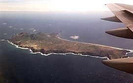 The island is characterized by two areas: the accidented northeast (mountainous, with rocky ledges and cliffs), and a coastal plain in the southwest (that includes a nine kilometre long white sand beach, giving the island an advantage over neighbouring Madeira). The mountainous northeast part of the island, consists of two geomorphological structures that includes: an area of peaks, Pico do Castelo (437 meters), Pico da Juliana (447 meters), Pico da Gandaia (499 meters) and Pico do Facho (517 meters); and between the eastern coast and this area, a series of minor peaks, Pico do Maçarico (285 meters), Pico do Concelho (324 meters) and Pico Branco (450 meters). The southwest part of the island, although relatively flat, includes a series of elevations 100 meters in height or greater, such as Pico Ana Fereira (283 meters), Pico do Espigão (270 meters) and the Cabeço do Zimbralinho (183 meters). The slope of the western part of the island slopes from 150 meters to the south coast reaching the sandy beachs of Porto Santo. A third system, in the west-northwest, that includes Cabeço da Bárbara Gomes (227 meters) and Cabeço das Canelinhas (176 meters) is distinct from the areas identified. The island is encircled by an oceanic platform between 20 and 37 km2, with a minimum depth of 8 meters (Baixa do Noroeste), and limited by the flanks of a large submarine volcano.
The island's submarine activity occurred during the Miocene
epoch, producing basaltic eruptions that persisted to the Quaternary
period. There were three phases of distinct volcanism, followed by periods of calm associated with sedimentation:
, is the city of Vila Baleira
([ˈvilɐ bɐˈlɐiɾɐ]), also known as Porto Santo.
Although a small island, the Porto Santo community has its own schools, health-care centre, police detachments, a gymnasium, churches, several local squares, a Congress Centre, museum, shopping centres, bars, hotels and restaurants.
, which has emerged through hotel construction in the 20th century and is based on the attractions of the beaches and temperate climate.
The island has a golf course
that was designed by Spanish golfing champion Seve Ballesteros; Porto Santo Golfe
hosted the Madeira Islands Open in 2009, as part of the European Tour. Once the planned second course is completed, Porto Santo Golfe will be the largest course in Madeira: there is currently one 18-hole golf course and one nine-hole course. In addition, Porto Santo's Golf Complex includes eight tennis courts and an equestrian centre (Pico Ana Ferreira).
The island has an international airport
, with routine flights to Madeira Airport
(about a 15-minute flight away); the nearest place to Porto Santo is Machico
(on Madeira). The Porto Santo Airport
(PXO) has many connections with both domestic (Ponta Delgada
, Lisbon
, Oporto and Faro
) and (occasionally) international flights (including several charters to England
, Italy
, Germany
, Belgium
, France
and Spain
).
Portugal
Portugal , officially the Portuguese Republic is a country situated in southwestern Europe on the Iberian Peninsula. Portugal is the westernmost country of Europe, and is bordered by the Atlantic Ocean to the West and South and by Spain to the North and East. The Atlantic archipelagos of the...
island 43 kilometres (26.7 mi) northeast of Madeira Island in the North Atlantic Ocean; it is the northernmost and easternmost island of the archipelago of Madeira, located in the Atlantic Ocean
Atlantic Ocean
The Atlantic Ocean is the second-largest of the world's oceanic divisions. With a total area of about , it covers approximately 20% of the Earth's surface and about 26% of its water surface area...
west of Europe and Africa.
History
João Gonçalves Zarco
João Gonçalves Zarco was a Portuguese explorer who established settlements and recognition of the Madeira Islands, and was appointed first captain of Funchal by Henry the Navigator.-Life:...
and Tristão Vaz Teixeira
Tristão Vaz Teixeira
Tristão Vaz Teixeira was a Portuguese navigator and explorer who, together with João Gonçalves Zarco and Bartolomeu Perestrelo, discovered the Madeira Islands...
had been ordered (by King John I
John I of Portugal
John I KG , called the Good or of Happy Memory, more rarely and outside Portugal the Bastard, was the tenth King of Portugal and the Algarve and the first to use the title Lord of Ceuta...
) to discover new territory west of Africa, and had been sent off-course by a storm. The island's name Porto Santo (English: Holy Harbour) was derived from the sailors' stories of their discovery of a sheltered bay during the tempest, which was seen as divine deliverance.
Bartolomeu Perestrelo
Bartolomeu Perestrelo
Bartolomeu Perestrello , 1st Capitão Donatário, Lord and Governor of the Island of Porto Santo was a Portuguese navigator and explorer that is claimed to have discovered and populated Porto Santo Island together with João Gonçalves Zarco and Tristão Vaz Teixeira...
, a third member of the team that later explored the islands of the Madeira, became the first Captain-donatorio
Donatorio
A Donatário, a Portuguese word roughly meaning 'endowed' sometimes anglicized as Donatary, was a private person who was bestowed by the Crown with a considerable piece of land, called a donátaria, which was handed over at his discretion, exempt from normal colonial administration through some...
of Porto Santo, by royal award in November 1445.
During the first centuries of settlement, life on Porto Santo was harsh, owing to the scarcity of potable water and constant attacks by Barbary Coast
Barbary Coast
The Barbary Coast, or Barbary, was the term used by Europeans from the 16th until the 19th century to refer to much of the collective land of the Berber people. Today, the terms Maghreb and "Tamazgha" correspond roughly to "Barbary"...
pirates and French privateers.
The famous explorer Christopher Columbus
Christopher Columbus
Christopher Columbus was an explorer, colonizer, and navigator, born in the Republic of Genoa, in northwestern Italy. Under the auspices of the Catholic Monarchs of Spain, he completed four voyages across the Atlantic Ocean that led to general European awareness of the American continents in the...
married Bartolomeu Perestrelo's daughter, and for a while lived on Porto Santo.
Physical geography
The island's submarine activity occurred during the Miocene
Miocene
The Miocene is a geological epoch of the Neogene Period and extends from about . The Miocene was named by Sir Charles Lyell. Its name comes from the Greek words and and means "less recent" because it has 18% fewer modern sea invertebrates than the Pliocene. The Miocene follows the Oligocene...
epoch, producing basaltic eruptions that persisted to the Quaternary
Quaternary
The Quaternary Period is the most recent of the three periods of the Cenozoic Era in the geologic time scale of the ICS. It follows the Neogene Period, spanning 2.588 ± 0.005 million years ago to the present...
period. There were three phases of distinct volcanism, followed by periods of calm associated with sedimentation:
- 1st Phase - associated with basaltic lava, pyroclastic flows, trachyte domes that were to form Pico do Concelho, Pico do Facho, Pico do Juliana and the Ponta da Calheta. This period was followed by a period of marine fossil accumulation, concentrated in the northeast of the island to about 300 meters altitude (around Pico do Juliana, Pico de Ana Ferreira and Ribeira do Moledo;
- 2nd Phase - this was a period of fissural volcanism that cut across and metamorphosed the older formations, occurring in the early PliocenePlioceneThe Pliocene Epoch is the period in the geologic timescale that extends from 5.332 million to 2.588 million years before present. It is the second and youngest epoch of the Neogene Period in the Cenozoic Era. The Pliocene follows the Miocene Epoch and is followed by the Pleistocene Epoch...
period; - 3rd Phase - was an intrusive phase, resulting in a number of faults and dikes that cut across the CalcareousCalcareousCalcareous is an adjective meaning mostly or partly composed of calcium carbonate, in other words, containing lime or being chalky. The term is used in a wide variety of scientific disciplines.-In zoology:...
fossils. Likely occurring in the PliocenePlioceneThe Pliocene Epoch is the period in the geologic timescale that extends from 5.332 million to 2.588 million years before present. It is the second and youngest epoch of the Neogene Period in the Cenozoic Era. The Pliocene follows the Miocene Epoch and is followed by the Pleistocene Epoch...
, it was followed by deposits of layers of detritic and calcareous sediments, that included brownish-red alluvial layers, along the island's flanks and beach.
Climate
Human geography
The main urban area, which is one of only five Portuguese municipalities that have only one parishFreguesia
Freguesia is the Portuguese term for a secondary local administrative unit in Portugal and some of its former colonies, and a former secondary local administrative unit in Macau, roughly equivalent to an administrative parish. A freguesia is a subdivision of a concelho, the Portuguese synonym term...
, is the city of Vila Baleira
Vila Baleira
Vila Baleira is the city and municipal seat of the island of Porto Santo, in the Portuguese Madeiran archipelago. It is an example of one of the few settlements in Portugal with only one civil parish, and only became a city on 6 August 1996....
([ˈvilɐ bɐˈlɐiɾɐ]), also known as Porto Santo.
Although a small island, the Porto Santo community has its own schools, health-care centre, police detachments, a gymnasium, churches, several local squares, a Congress Centre, museum, shopping centres, bars, hotels and restaurants.
Economy
The main industry on the island of Porto Santo is tourismTourism
Tourism is travel for recreational, leisure or business purposes. The World Tourism Organization defines tourists as people "traveling to and staying in places outside their usual environment for not more than one consecutive year for leisure, business and other purposes".Tourism has become a...
, which has emerged through hotel construction in the 20th century and is based on the attractions of the beaches and temperate climate.
The island has a golf course
Golf course
A golf course comprises a series of holes, each consisting of a teeing ground, fairway, rough and other hazards, and a green with a flagstick and cup, all designed for the game of golf. A standard round of golf consists of playing 18 holes, thus most golf courses have this number of holes...
that was designed by Spanish golfing champion Seve Ballesteros; Porto Santo Golfe
Porto Santo Golfe
Porto Santo Golfe is a 27-hole golf club on the scenic island of Porto Santo in Madeira, Portugal. It opened on 1 October 2004 and was designed by the Spanish 5-time major winner, Seve Ballesteros....
hosted the Madeira Islands Open in 2009, as part of the European Tour. Once the planned second course is completed, Porto Santo Golfe will be the largest course in Madeira: there is currently one 18-hole golf course and one nine-hole course. In addition, Porto Santo's Golf Complex includes eight tennis courts and an equestrian centre (Pico Ana Ferreira).
The island has an international airport
International airport
An international airport is any airport that can accommodate flights from other countries and are typically equipped with customs and immigration facilities to handle these flights to and from other countries...
, with routine flights to Madeira Airport
Madeira Airport
-Incidents and accidents:*On 5 March 1973, an Aviaco Sud Caravelle 10R crashed into the sea during approach, losing the aircraft and three crew....
(about a 15-minute flight away); the nearest place to Porto Santo is Machico
Machico
Machico is a city and municipality in the northeastern part of the island of Madeira, in the Autonomous Region of Madeira. The easternmost municipality on the island, it is also the third most populous area; its population was 21,747...
(on Madeira). The Porto Santo Airport
Porto Santo Airport
-External links:* *...
(PXO) has many connections with both domestic (Ponta Delgada
Ponta Delgada
Ponta Delgada is a city and municipality on the island of São Miguel in the archipelago of the Azores, an autonomous region of Portugal. It includes 44,403 residents in the urban area, and approximately 20,113 inhabitants in the three central parishes that comprise the historical city: São Pedro,...
, Lisbon
Lisbon
Lisbon is the capital city and largest city of Portugal with a population of 545,245 within its administrative limits on a land area of . The urban area of Lisbon extends beyond the administrative city limits with a population of 3 million on an area of , making it the 9th most populous urban...
, Oporto and Faro
Faro, Portugal
Faro is the southernmost city in Portugal. It is located in the Faro Municipality in southern Portugal. The city proper has 41,934 inhabitants and the entire municipality has 58,305. It is the seat of the Faro District and capital of the Algarve region...
) and (occasionally) international flights (including several charters to England
England
England is a country that is part of the United Kingdom. It shares land borders with Scotland to the north and Wales to the west; the Irish Sea is to the north west, the Celtic Sea to the south west, with the North Sea to the east and the English Channel to the south separating it from continental...
, Italy
Italy
Italy , officially the Italian Republic languages]] under the European Charter for Regional or Minority Languages. In each of these, Italy's official name is as follows:;;;;;;;;), is a unitary parliamentary republic in South-Central Europe. To the north it borders France, Switzerland, Austria and...
, Germany
Germany
Germany , officially the Federal Republic of Germany , is a federal parliamentary republic in Europe. The country consists of 16 states while the capital and largest city is Berlin. Germany covers an area of 357,021 km2 and has a largely temperate seasonal climate...
, Belgium
Belgium
Belgium , officially the Kingdom of Belgium, is a federal state in Western Europe. It is a founding member of the European Union and hosts the EU's headquarters, and those of several other major international organisations such as NATO.Belgium is also a member of, or affiliated to, many...
, France
France
The French Republic , The French Republic , The French Republic , (commonly known as France , is a unitary semi-presidential republic in Western Europe with several overseas territories and islands located on other continents and in the Indian, Pacific, and Atlantic oceans. Metropolitan France...
and Spain
Spain
Spain , officially the Kingdom of Spain languages]] under the European Charter for Regional or Minority Languages. In each of these, Spain's official name is as follows:;;;;;;), is a country and member state of the European Union located in southwestern Europe on the Iberian Peninsula...
).