
Machico
Encyclopedia
Machico is a city and municipality
in the northeastern part of the island of Madeira
, in the Autonomous Region of Madeira. The easternmost municipality on the island, it is also the third most populous area; its population was 21,747 (in 2001). The town, proper, had a population of just over 10,000 inhabitants.
and Tristão Vaz Teixeira
disembarked on the beach of Machico, beginning the era of Portuguese
discoveries. On the beach a mass of thanksgiving was celebrated by Franciscan priests, in honour of the visitation of Saint Elizabeth
(2 June), an image of which accompanied the expedition.
Many hypothesises have developed as to the origin of the name of the municipality. The most remembered, and not the least disputed, comes from the romanticized legend of the English lovers Robert Machim and Ana d´Arfet. As the legend explains, the two lovers escaped from England (where their love was forbidden and condemned by the Church), suffered the tragedy of a shipwreck and died on the island that became Madeira, where later the first Portuguese explorers encountered two crosses to which they attributed to the lovers: the name appears to be a corruption of the surname Machim.
On 8 May 1440, the Infante Henry the Navigator awarded Tristão Vaz and his descendants the Captaincy
of Machico (which included the Ponta da Oliveira, in Caniço, to the Ponta do São Lourenço and from there to the Ponta do Tristão, in Porto Moniz), and by right the first Captaincy in the archipelago of Madeira. The first settlers eked out a meagre subsistence, as a Franciscan monk noted:
Still in the 15th century, taking advantage of the abundant water and excellent climate, the first colonists began to cultivate sugar cane, and the first machinery used to process the pulp appeared immediately, facilitating the export to Europe. Although the Captaincy did not have the best lands to cultivate the plant (by 1494 one-fifth of regional production), the village that developed at Machico's beachhead was the centre of the processing of this spice. As the monk Jerónimo Dias Leite indicated: "...the first sugar sold on this island of Madeira was in the town of Machico where there began a make and collect three arroba
s [equivalent to 96 pounds] to sell, each arroba [32 pounds] sold for five cruzeiros [historical coinage of Portugal]...".
Machico grew to this lucrative commerce, while Machiquenses families become socially powerful and wealthy from the trade, including the families of the Captains-Donatários (Tristão Vaz's descendants). It was the Teixeira family that erected the first Matriz Church in Machico at the end of the 15th century, in honour of Nossa Senhora da Conceição (Our Lady of Conception).
During the second half of the 15th century, along with Funchal, Machico was elevated to town (1451) and continued to grow, following the course of the ravine into the valley. Two poles developed: the right margin, that included the main barrio and the town's public institutions (municipal chamber, customshouse and church), and the left margin, that included nucleus of Banda d'Além, the Misericórdia (social centre) and Chapel of Christ, later known as the actual Chapel of Nosso Senhor dos Milagres (Our Lady of Miracles).
In 1803, a landslide was responsible for the destruction of various homes, destroying hedges and walls, the main bridge along the ravine and the Chapel of Nosso Senhor dos Milagres.
Machico also became a front-line during the Revolta da Madeira (Madeira Revolt) in April 1931.
, 20 km southeast of Santana and west-southwest of Porto Santo
in the extreme eastern portion of the island of Madeira. It is linked by road from Funchal (the regional capital), to the Santana and the villages of Ribeira Seca and Caniçal
. To the existence of mountains on the western coast, it is sandwiched along the coast from the rest of the islands' settlements, while forests lie towards the interior and grasslands cover the northeastern corner of the municipality.
Geomorphologically, the municipality is dominated by steeped and inclined topography, except in the Machico valley (where slopes are gentle), formed by two mountain ranges: in the east Pico do Facho and to the west the Queimada plateau. Examples of these differences include the area south of Porto da Cruz (in the watershed of Ribeira do Juncal) and in Caniçal (in the Ribeira da Palmeira watershed).
Due to its location and morphological characteristics, the climate of Madeira is complex, whose difference from place to place is accentuated, even in areas relatively close. Machico temperatures are relatively moderate throughout the year, with variation relatively low (only accentuated between elevations).
Machico has several primary schools, junior and senior secondary schools, banks, main post office and public square, along with public beaches.
Municipality
A municipality is essentially an urban administrative division having corporate status and usually powers of self-government. It can also be used to mean the governing body of a municipality. A municipality is a general-purpose administrative subdivision, as opposed to a special-purpose district...
in the northeastern part of the island of Madeira
Madeira
Madeira is a Portuguese archipelago that lies between and , just under 400 km north of Tenerife, Canary Islands, in the north Atlantic Ocean and an outermost region of the European Union...
, in the Autonomous Region of Madeira. The easternmost municipality on the island, it is also the third most populous area; its population was 21,747 (in 2001). The town, proper, had a population of just over 10,000 inhabitants.
History
In calm waters of early after, on 1 July 1419, João Gonçalves ZarcoJoão Gonçalves Zarco
João Gonçalves Zarco was a Portuguese explorer who established settlements and recognition of the Madeira Islands, and was appointed first captain of Funchal by Henry the Navigator.-Life:...
and Tristão Vaz Teixeira
Tristão Vaz Teixeira
Tristão Vaz Teixeira was a Portuguese navigator and explorer who, together with João Gonçalves Zarco and Bartolomeu Perestrelo, discovered the Madeira Islands...
disembarked on the beach of Machico, beginning the era of Portuguese
Portugal
Portugal , officially the Portuguese Republic is a country situated in southwestern Europe on the Iberian Peninsula. Portugal is the westernmost country of Europe, and is bordered by the Atlantic Ocean to the West and South and by Spain to the North and East. The Atlantic archipelagos of the...
discoveries. On the beach a mass of thanksgiving was celebrated by Franciscan priests, in honour of the visitation of Saint Elizabeth
Elizabeth of Aragon
Elizabeth of Aragon, also known as Saint Elizabeth of Portugal, T.O.S.F. , was queen consort of Portugal, a tertiary of the Franciscan Order and is venerated as a saint of the Roman Catholic Church.-Biography:Elizabeth was a descendant of one of the most powerful families in Europe:...
(2 June), an image of which accompanied the expedition.
Many hypothesises have developed as to the origin of the name of the municipality. The most remembered, and not the least disputed, comes from the romanticized legend of the English lovers Robert Machim and Ana d´Arfet. As the legend explains, the two lovers escaped from England (where their love was forbidden and condemned by the Church), suffered the tragedy of a shipwreck and died on the island that became Madeira, where later the first Portuguese explorers encountered two crosses to which they attributed to the lovers: the name appears to be a corruption of the surname Machim.
On 8 May 1440, the Infante Henry the Navigator awarded Tristão Vaz and his descendants the Captaincy
Captaincy
A captaincy is a historical administrative division of the former Spanish and Portuguese colonial empires. Each was governed by a captain general.-In the Portuguese Empire:...
of Machico (which included the Ponta da Oliveira, in Caniço, to the Ponta do São Lourenço and from there to the Ponta do Tristão, in Porto Moniz), and by right the first Captaincy in the archipelago of Madeira. The first settlers eked out a meagre subsistence, as a Franciscan monk noted:
Still in the 15th century, taking advantage of the abundant water and excellent climate, the first colonists began to cultivate sugar cane, and the first machinery used to process the pulp appeared immediately, facilitating the export to Europe. Although the Captaincy did not have the best lands to cultivate the plant (by 1494 one-fifth of regional production), the village that developed at Machico's beachhead was the centre of the processing of this spice. As the monk Jerónimo Dias Leite indicated: "...the first sugar sold on this island of Madeira was in the town of Machico where there began a make and collect three arroba
Arroba
The word arroba has its origin in Arabic ar-rubʿ , the fourth part .Arroba was a Spanish and Portuguese customary unit of weight, mass or volume. Its symbol is @. In weight it was equal to 25 pounds in Spain, and 32 pounds in Portugal.The unit is still used in Portugal by cork merchants, and in...
s [equivalent to 96 pounds] to sell, each arroba [32 pounds] sold for five cruzeiros [historical coinage of Portugal]...".
Machico grew to this lucrative commerce, while Machiquenses families become socially powerful and wealthy from the trade, including the families of the Captains-Donatários (Tristão Vaz's descendants). It was the Teixeira family that erected the first Matriz Church in Machico at the end of the 15th century, in honour of Nossa Senhora da Conceição (Our Lady of Conception).
During the second half of the 15th century, along with Funchal, Machico was elevated to town (1451) and continued to grow, following the course of the ravine into the valley. Two poles developed: the right margin, that included the main barrio and the town's public institutions (municipal chamber, customshouse and church), and the left margin, that included nucleus of Banda d'Além, the Misericórdia (social centre) and Chapel of Christ, later known as the actual Chapel of Nosso Senhor dos Milagres (Our Lady of Miracles).
In 1803, a landslide was responsible for the destruction of various homes, destroying hedges and walls, the main bridge along the ravine and the Chapel of Nosso Senhor dos Milagres.
Machico also became a front-line during the Revolta da Madeira (Madeira Revolt) in April 1931.
Geography
Physical geography
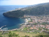
Machico is located 17 km northeast of Funchal, northwest of the uninhabitable Savage IslandsSavage Islands
The Savage Islands, also referred to as the Salvage Islands or the Selvagens Islands, of Sé. They are designated a Nature Reserve, comprising two areas: one on Selvagem Grande Island and the second on Selvagem Pequena Island.-Geography:...
, 20 km southeast of Santana and west-southwest of Porto Santo
Porto Santo Island
Porto Santo Island is a Portuguese island northeast of Madeira Island in the North Atlantic Ocean; it is the northernmost and easternmost island of the archipelago of Madeira, located in the Atlantic Ocean west of Europe and Africa.- History :...
in the extreme eastern portion of the island of Madeira. It is linked by road from Funchal (the regional capital), to the Santana and the villages of Ribeira Seca and Caniçal
Caniçal
Caniçal is a civil parish in the municipality of Machico in the Portuguese archipelago of Madeira. In 2001 the population was less than 4000 inhabitants, in an 11.85 km² area of islets and raised escarpments...
. To the existence of mountains on the western coast, it is sandwiched along the coast from the rest of the islands' settlements, while forests lie towards the interior and grasslands cover the northeastern corner of the municipality.
Geomorphologically, the municipality is dominated by steeped and inclined topography, except in the Machico valley (where slopes are gentle), formed by two mountain ranges: in the east Pico do Facho and to the west the Queimada plateau. Examples of these differences include the area south of Porto da Cruz (in the watershed of Ribeira do Juncal) and in Caniçal (in the Ribeira da Palmeira watershed).
Due to its location and morphological characteristics, the climate of Madeira is complex, whose difference from place to place is accentuated, even in areas relatively close. Machico temperatures are relatively moderate throughout the year, with variation relatively low (only accentuated between elevations).
Human geography
Administratively, the municipality is governed from its seat in the city of Machico, but five local juntas de freguesia (civil parish government) handle issues in the communities of:- Água de PenaÁgua de PenaÁgua de Pena is a civil parish in the municipality of Machico in the Portuguese archipelago of Madeira. In 2001, the population hovered around 1759 residents, in a flat escarpment extending 1.74 kilometres into an area of 5.15 km² along the south-east coast of the island of...
- supposedly the area explored by João Gonçalos Zarco and his crew after anchoring in Madeira, Pena is the smallest parish in the municipality, and developed from various reconfigurations of the border between Machico and Santa CruzSanta Cruz, MadeiraSanta Cruz is a municipality, a parish and a city in the eastern part of the island of Madeira. Much of the municipality is mountainous and apart from residential areas, farmlands and orchards cover the remainder of the land...
, today its population includes 1700 inhabitants (2001 census); - CaniçalCaniçalCaniçal is a civil parish in the municipality of Machico in the Portuguese archipelago of Madeira. In 2001 the population was less than 4000 inhabitants, in an 11.85 km² area of islets and raised escarpments...
- an important fishing community of 3893 inhabitants (2001), the parish of Caniçal (which means area of many fishing lines/rods) extends into the eastern coast of Madeira island to the tip of the cliffs of the promontory/escarpment of Ponta de São Lourenço; - Machico - historical village, it is the largest parish in terms of population and concentrated residents, with a population of 11,977 (2006 Estimate);
- Porto da CruzPorto da CruzPorto da Cruz is a civil parish in the municipality of Machico in the northeastern corner of Madeira. In 2001 the resident population included 2793 people, dispersed throughout an area of 25.22 km² .-History:The origin of the communities name came from the fact that the original discoverer...
- largest parish in area and the smallest parish in density (2793 inhabitants), whose name was derived from the original discoverers, who fixed a steel cross by the harbour, so that travellers would be able to identify the location; - Santo António da SerraSanto António da Serra (Machico)Santo António da Serra is a civil parish in the interior of the municipality of Machico, on the island of Madeira. The parish, not to be confused with another Santo António das Serra, in the neighbouring municipality of Santa Cruz, had a population of 1355 within an area of 8.62 km²...
- considered the smallest parish in terms of population (1355 residents), it is also one of the few interior parishes on the island, created from the disharmony between the local authorities (which forced the local governor to divide the original parish between Machcico and Santo Cruz).
Machico has several primary schools, junior and senior secondary schools, banks, main post office and public square, along with public beaches.