

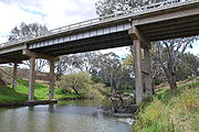
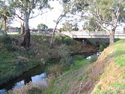
Werribee River
Encyclopedia
Melbourne
Melbourne is the capital and most populous city in the state of Victoria, and the second most populous city in Australia. The Melbourne City Centre is the hub of the greater metropolitan area and the Census statistical division—of which "Melbourne" is the common name. As of June 2009, the greater...
, Victoria, Australia. The headwaters of a tributary, the Lerderderg River
Lerderderg River
The Lerderderg River is a river in Victoria, Australia. The river begins in the Lerderderg State Forest and ends when it merges into the Werribee River just out of the town of Bacchus Marsh....
, are north of Ballan
Ballan, Victoria
Ballan is a small town in the state of Victoria, Australia located on the Werribee River north west of Melbourne. At the 2006 census, Ballan had a population of 1,807.It is the main administrative centre for the Shire of Moorabool Local Government Area....
near Daylesford
Daylesford, Victoria
Daylesford is a town located in the Shire of Hepburn, Victoria, Australia. It is a former goldmining town about 115 kilometres north-west of Melbourne, in the foothills of the Great Dividing Range. At the 2006 census, Daylesford had a population of 3,073...
and it flows across the basalt plain, through the suburb of Werribee
Werribee, Victoria
Werribee is a city in Melbourne, Australia, 32 km south-west from Melbourne's central business district. Its Local Government Area is the City of Wyndham. At the 2006 Census, Werribee had a population of 36,641. Statistically, Werribee is considered part of Greater Melbourne.Werribee is...
to enter Port Phillip
Port Phillip
Port Phillip Port Phillip Port Phillip (also commonly referred to as Port Phillip Bay or (locally) just The Bay, is a large bay in southern Victoria, Australia; it is the location of Melbourne. Geographically, the bay covers and the shore stretches roughly . Although it is extremely shallow for...
. A linear park follows the Werribee River along much of its course. In total the Werribee River completes a journey of approximately 110 km .
The river flows through the Werribee Gorge State Park
Werribee Gorge State Park
Werribee Gorge State Park is a state park in Victoria, Australia. It is located near Bacchus Marsh and is popular with bushwalkers and rock climbers, all attracted to its spectacular views and significant geological features.- Werribee Gorge :...
before being utilised for irrigation of market garden
Market garden
A market garden is the relatively small-scale production of fruits, vegetables and flowers as cash crops, frequently sold directly to consumers and restaurants. It is distinguishable from other types of farming by the diversity of crops grown on a small area of land, typically, from under one acre ...
s at Bacchus Marsh, then through Werribee
Werribee, Victoria
Werribee is a city in Melbourne, Australia, 32 km south-west from Melbourne's central business district. Its Local Government Area is the City of Wyndham. At the 2006 Census, Werribee had a population of 36,641. Statistically, Werribee is considered part of Greater Melbourne.Werribee is...
where it is crossed by the Maltby By-pass. It then flows through the Werribee Open Range Zoo
Werribee Open Range Zoo
Werribee Open Range Zoo is an African themed zoo in Werribee, about south-west of Melbourne, Victoria, Australia. It is part of the Zoological Parks and Gardens Board or 'Zoos Victoria' which also includes Melbourne Zoo and Healesville Sanctuary. It is situated on approximately and is located on...
in Werribee Park
Werribee Park
Werribee Park is the estate of a historical building in Werribee, Victoria, Australia. It includes Werribee Park Mansion, the Victoria State Rose Garden, formal gardens, the Werribee Park National Equestrian Centre, the Werribee Open Range Zoo, a contemporary sculpture walk and a natural riverine...
, and finally the small coastal settlement of Werribee South
Werribee South, Victoria
Werribee South is a suburb in Melbourne, Victoria, Australia, 32 km south-west from Melbourne's central business district. Its Local Government Area is the City of Wyndham...
before entering Port Phillip
Port Phillip
Port Phillip Port Phillip Port Phillip (also commonly referred to as Port Phillip Bay or (locally) just The Bay, is a large bay in southern Victoria, Australia; it is the location of Melbourne. Geographically, the bay covers and the shore stretches roughly . Although it is extremely shallow for...
. The Western Treatment Plant
Werribee Sewage Farm
Werribee Sewage Farm or, more formally, the Western Treatment Plant of Melbourne Water, is an 110 km² sewage treatment farm adjacent to the town of Werribee, 30 km west of the city of Melbourne, Victoria, Australia, on the coast of Port Phillip Bay...
, a sewage treatment site, is located near the mouth of the river, and supplies irrigation needs to the zoo.
The Werribee River Trail
Werribee River Trail
The Werribee River Trail is a shared use path for cyclists and pedestrians, which follows Werribee River in the outer western suburb of Werribee in Melbourne, Victoria, Australia.North of the train line the path runs both sides of the river...
winds beside the Werribee River from Davis Creek in Tarneit to the Princes Highway in Werribee.
History
Bunurong
The Bunurong are Indigenous Australians of the Kulin nation, who occupy South-Central Victoria, Australia. Prior to European settlement, they lived as all people of the Kulin nation lived, sustainably on the land, predominantly as hunters and gatherers, for tens of thousands of years...
tribe whose six clans lived along the Victorian
Victoria (Australia)
Victoria is the second most populous state in Australia. Geographically the smallest mainland state, Victoria is bordered by New South Wales, South Australia, and Tasmania on Boundary Islet to the north, west and south respectively....
coast across the Mornington Peninsula
Mornington Peninsula
The Mornington Peninsula is a peninsula located south-east of Melbourne in Victoria, Australia. It is surrounded by Port Phillip to the west, Western Port to the east and Bass Strait to the south, and is connected to the mainland in the north. Geographically, the peninsula begins its protrusion...
, Western Port
Western Port
Western Port, is sometimes called "Western Port Bay", is a large tidal bay in southern Victoria, Australia opening into Bass Strait. It is the second largest bay in Victoria. Geographically, it is dominated by the two large islands; French Island and Phillip Island. Contrary to its name, it lies to...
Bay to Wilsons Promontory
Wilsons Promontory National Park
Wilsons Promontory National Park, commonly known as Wilsons Prom or The Prom, is a national park in the Gippsland region of Victoria , 157 km southeast of Melbourne....
.
The explorers Hume and Hovell
Hume and Hovell expedition
The Hume and Hovell expedition was one of the most important journeys of explorations undertaken in eastern Australia. In 1824 the Governor of New South Wales, Sir Thomas Brisbane, commissioned Hamilton Hume and former Royal Navy Captain William Hovell to lead an expedition to find new grazing land...
camped by the river on 15 December 1824 and named it the Arndell after Hovell's father-in-law. John Helder Wedge
John Helder Wedge
John Helder Wedge was a surveyor, explorer and politician in Van Diemen's Land .Wedge was the second son of Charles Wedge of Shudy Camps, Cambridge, England. John Wedge learned the basics of surveying from his father...
're-discovered' the river in 1835 and initially called it the Peel, but then decided to call it the Ex or Exe. Exford, an early crossing place on the river, is derived from this name. One of the local Wautharong
Wautharong
Wathaurong, also called the Wada wurrung, are an Indigenous Australian tribe living in the area near Melbourne, Geelong and the Bellarine Peninsula. They are part of the Kulin alliance. The Wathaurong language was spoken by 25 clans south of the Werribee River and the Bellarine Peninsula to Streatham...
speaking Kulin
Kulin
The Kulin nation, was an alliance of five Indigenous Australian nations in Central Victoria, Australia, prior to European settlement. Their collective territory extended to around Port Phillip and Western Port, up into the Great Dividing Range and the Loddon and Goulburn River valleys. To their...
tribesman that accompanied Wedge said the name for the stream was 'Weariby Yallock' ('yallock' meaning 'stream'). The spelling changed to the present form of Werribee, and the original aboriginal word meant spine or backbone.
In the late 1830s and 1840s the Werribee River was the scene of conflicts between the Wautharong
Wautharong
Wathaurong, also called the Wada wurrung, are an Indigenous Australian tribe living in the area near Melbourne, Geelong and the Bellarine Peninsula. They are part of the Kulin alliance. The Wathaurong language was spoken by 25 clans south of the Werribee River and the Bellarine Peninsula to Streatham...
people and the European colonisers. The squatter Charles Franks and a shepherd were speared to death near Mount Cottrell in July 1836. This resulted in a punitive party led by John Batman
John Batman
John Batman was an Australian grazier, businessman and explorer who is best known for his role in the founding of a settlement which became Melbourne and the colony of Victoria.-Life:...
which came upon a large party of aborigines and indiscriminately shot and killed at least ten. There are accounts of arsenic laced flour being given to local aborigines.
In 1851 a substantial timber bridge was built to cross the Werribee River to replace an earlier wooden bridge. In 1852 this bridge was washed away when the Werribee river flooded.
In August 2004 the Victorian Government pledged $300,000 towards restoring the Werribee River, removing willows choking the river around the township and replacing them with native plants in a habitat restoration project.
Things to Do
Exploring the river offers an array of outdoor opportunities and is indeed a favorite past-time for many local residents. An extensive network of hard surface bike and walking trails along the river showcase the plethora of native flora and fauna that inhabit the river and its banks.There are many fishing spots along the river and canoe/boat launching facilities are located at the Werribee South Boat Ramp and Riverbend Historical Park.
Bird watching is also a popular activity however care must be taken as there are known to be Eastern Snakes and other deadly fauna inhabiting the area.
See also
- 2006 Melbourne teenage DVD controversy2006 Melbourne teenage DVD controversyCunt: The Movie is a 2006 DVD produced by a group of Melbourne based high school students who refer to themselves as "The Teenage Kings of Werribee"...
- involved several incidents which occurred in Werribee including some at the Werribee River.