
Phetchabun Province
Encyclopedia
Phetchabun is one of the northern provinces
(changwat) of Thailand
. Neighboring provinces are (from north clockwise) Loei
, Khon Kaen
, Chaiyaphum
, Lopburi
, Nakhon Sawan
, Phichit and Phitsanulok
.
, in the area between the northern and the central region.
The province lies in the broad fertile river valley of the Pa Sak River
, with mountains of the Phetchabun mountain range
to the east and west.
It is surrounded by places of interest, many well-known national
parks, beautiful waterfalls and great lakes.
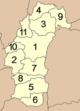
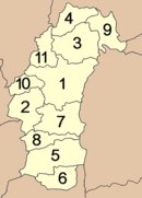 The province is subdivided in 11 districts (amphoe
). These are further subdivided into 117 subdistricts (tambon
) and 1261 villages (muban
).
There is no railway system to Phetchabun
By Car
Road No.1 from capital city(Bangkok) to Saraburi province and then Road No.21 to Petchabun
Road No.12 from Khonkaen (central province of the northeastern region) to Lom Sak and then Road 21. southward to Phetchabun.
word vajra
meaning "diamond
" (or weapon of Indra
), and the word bun from Sanskrit purna meaning "full", "perfect" or "whole
". Hence the name of the province literally means "Perfect Diamond".
Initially, the province was called "Phe-cha-buth" as "Phuenchapura", which means the city that is plenty of crops. The reason for being given such name is because the province is very fertile and full of natural resources. Because of the fertility of the land, Phetchabun has always been agriculturally productive area.
– namely the Sukhothai Kingdom
, and the Ayutthaya
Period of the great King Narai.
In the Thesaphiban administrative reforms at the beginning of the 20th century the province together with the province of Lom Sak to the north formed the monthon Phetchabun. As it was the smallest monthon, it was also the first monthon to be dissolved in 1915, after being temporarily administrated from Monthon Phitsanulok between 1903 and 1907. The province Lom Sak was abolished and included into Phetchabun in 1932.
Phetchabun province is situated between the northern and the central region.
From historical evidence, it is believed that Phetchabun was established by two kingdoms – namely the Sukhothai Kingdom and the Ayutthaya Period of the great King Narai. Initially the province was called "Phe-cha-buth" as "Phuenchapura", which means the city that is plenty of crops.
The reason for being given its name is because the province is very fertile and full of natural resources.
During the period between 1968-1982 communist insurgents established their base in the mountains in this province. From hidden locations they fought occasional skirmishes against the Thai Army.
Today, Phetchabun is a province
with rich tourism potential such as fascinating nature, prosperous history for more than 1,400 years and indigenous traditional ceremonies.
shows a diamond
on a mountain, as diamonds are found in the province. In the front are tobacco
plants as one of the crops grown in the province.
The provincial tree is the Tamarind
(Tamarindus indica).
. It was designated to be " Little Switzerland
" from many visitors, because of beautiful scenery and cool weather like Switzerland
. It was once a battle field against communist insurgents conducted their struggles against the authorities. Its charming scenery and great weather allure tourists to see the mountain – top, army base turned into a museum, a Chedi
containing a holy relic and enjoy trekking in the open zoo and non – hunting areas.
is an immense tract of forest still in its original state.
and Phetchabun Province, Phu Hin Rong Kla
is a national park
with scenic attractions
and historical significance. In the past, it was the stage of armed conflicts
due to political differences between the Thai people.
Phu Hin Rong Kla's climate is similar to Phu Kra Dung and Phu Luang.
Because of its high altitude, the park is cool all year round. In the cool season, when temperature can occasionally drop to freezing point,
mist can cool and pleasant. The deciduous trees and cold flowers attract many tourists.
Park
is located in Baan Than Tip, Bung Num Tao District, Amphoe Lom Sak
. It
is a forest park of 8,750 rais in Khao Plok Lon Forest Reserve. In general,
the area consists of steep and high mountain ranges. The mixed deciduous
forest in the area is fairly rich.In the rainy season, the water
is swift with strong currents. For tourists who love excitement, this is a great opportunity for
them. Visitors can go downstream along the rapids called "Long
Kang." It is an exciting activity around Than Thip waterfall that is perfect for
acrobatic visitors.
century.
It was once the centre of contact between the Dvarravati Kingdom in the central plain basin
and the Khmer
Kingdom
in the Northeast. A twin-
city, there were over one hundred ancient sites all built with bricks and laterite, most of them have since crumbled.
There are also remains of several ponds spread out all over the area. Most of the ancient relics recovered are parts of architectural
nature such as elaborate lintels, plastered designs and sema stone and human
skeletons still are adorned with ornamental pieces. In 2000, it
got a Thailand Tourism Award for guaranteeing welfare of culture and ancient buildings.
The Phetchabun City Pillar Shrine (ศาลหลักเมืองเพชรบูรณ์) has been brought over from the ancient town of Si Thep and is considered the oldest such structure in Thailand.
Wat Trai Phum (วัดไตรภูมิ) on Phetcharat Road features a Buddha statue called Phra Buddha Mahadhamaracha cast in the ornamental Lop Buri style. The ritual bathing of the Buddha image or the traditional Um Phra Dam Nam ceremony is held during September each year.
The Huai Pa Dang Reservoir (อ่างเก็บน้ำห้วยป่าแดง) was created by the dam constructed to block the waterway to the west of town for irrigation purposes. It is a pleasant place for recreation and picnic with scenic natural views in the background, particularly in the morning and late afternoon.
Tat Mok National Park (อุทยานแห่งชาติตาดหมอก) has a huge waterfall fed by streams flowing down cracks and crevices of the mountains creating a beautiful 12-level fall. On both sides of the trails leading up to it are large, shady trees providing a pleasant surroundยing.
The Pho Khun Pha Mueang Memorial (อนุสาวรีย์พ่อขุนผาเมือง) at Lom Sak district in the north of Phetchabun commemorates this former ruler or the area, which was a contemporary of Sukhothai.
Phu Hin Rong Kla (ภูหินร่องกล้า) is a popular destination located along the Phitsanulok and Phetchabun borders and offers exotic scenery. It was once the base of communist’s resurgent fighting against the government some twenty years ago.
Si Thep Historical Park (อุทยานประวัติศาสตร์ศรีเทพ) is an ancient town where many architectural structures still remain indicative of its past prosperity during the 11th-18th Buddhist Centuries. A twin-city, there were over one hundred ancient sites all built with bricks and laterite, most of which have crumbled.
Khao Kho (เขาค้อ) is made up of mountain ranges to northwest of town about 1,174 metres above sea level covered in the main by deciduous plants. Very cold during November-February, it once was the base room which communist insurgents conducted their struggles against the authorities during 1968-1982.
Rai B.N. (ไร่บีเอ็น), is a private agriculture plantation growing cold-climate crops, including various flowers which alternately bloom throughout the year.
The Nam Nao National Park (อุทยานแห่งชาติน้ำหนาว) is an immense tract of forest still in perfect condition. With pineries, grasslands and virgin jungles, it is habitat to large number of animals and more than 100 species of birds. Attractions include:
Khanom Chin (ขนมจีน), popular food of Lom Kao district, is a noodle-like dish made from flour. It is served with gravy and side dish of various fresh local vegetables.
relate to the river
very much. Such
closeness is clearly reflected in the widely known festival
ceremonies
that call " Um Pha Dam Nam" or Dive the Buddha
Image into the Water
Festival . Phra Buddha Maha Thammaracha is highly revered ancient Buddha
image of Phetchabun Province
. This event is annually held on the fifteenth day
of the waning moon in the 10 th lunar month of during Sat Thai Period at Trai
Pum Temple
. The ceremony
starts at 1 P.M. The image is carried around the
town, so Buddhists can pay respect to it and stick gold leaf on its body. The
next morning, people make merit as it is Sat Thai Day. Food, including
Krayasat, and other necessities are given to monk
s. The Buddha image is then
taken to be immersed in the Pah Sak River by governor of Phetchabun. After
the ceremony
, the water in the river is regarded as sacred. As a result, people
swim in it or take the water to drink before the boat racing begins.
of Phetchabun
villagers for a long time. They believe this tradition
is the way to request
the god and the angle come to make merit with them. It is held annually
during the end of Buddhist Lent around Por Kun Pah Maung Monument
to
promote the honor of Por Kun Pah Maung and conserve this tradition
remain
stay with villagers eternally. In this celebration, there are many activities to
enjoy for instance the drum contest, the beautiful girl contest, an array of color
fills its streets and float lanterns that can only be seen in Phetchabun.
is grown mostly in Phetchabun due to the cool weather
and suitable environment. Farmers gain a lot of income from tamarind,
also it is the symbol of Phetchabun without arguing. Sweet
Tamarind
Fair is thus organized in Phetchabun to celebrate the harvest of this
fruit during January 17 - 25. This day is also called "Phetchabun’s Agriculture
Day." During the festival
, farmers bring their sweet tamarinds to sell at
reasonable price at Phetchabun’s provincial athletic field where contests
of sweet tamarinds and other crops are held. Besides this, there are other
agricultural exhibitions and entertainments organized during the event.
Provinces of Thailand
Thailand is divided into 76 provinces , which are geographically grouped into 6 regions. The capital Bangkok is not a province but a special administrative area and is included as the 77th province since it is administered at the same level as the other 76 provinces. The name of the provinces are...
(changwat) of Thailand
Thailand
Thailand , officially the Kingdom of Thailand , formerly known as Siam , is a country located at the centre of the Indochina peninsula and Southeast Asia. It is bordered to the north by Burma and Laos, to the east by Laos and Cambodia, to the south by the Gulf of Thailand and Malaysia, and to the...
. Neighboring provinces are (from north clockwise) Loei
Loei Province
Loei is one of the most sparsely populated provinces of Thailand, located in the North-East. Neighboring provinces are Nong Khai, Udon Thani, Nongbua Lamphu, Khon Kaen, Phetchabun, Phitsanulok...
, Khon Kaen
Khon Kaen Province
-History:The first city of the area was established in 1783 when Rajakruluang settled there with 330 people. King Rama I made Rajakruluang the first governor of the area when establishing tighter connections with the Isan area. The main city was moved six times until in 1879 it reached its modern...
, Chaiyaphum
Chaiyaphum Province
Chaiyaphum is one of the north-eastern provinces of Thailand. Neighboring provinces are Khon Kaen, Nakhon Ratchasima, Lopburi and Phetchabun.- Etymology :...
, Lopburi
Lopburi Province
Lop Buri is one of the central provinces of Thailand. Neighboring provinces are Phetchabun, Chaiyaphum, Nakhon Ratchasima, Saraburi, Phra Nakhon Si Ayutthaya, Ang Thong, Sing Buri and Nakhon Sawan.-Geography:...
, Nakhon Sawan
Nakhon Sawan Province
Nakhon Sawan is one of the provinces of Thailand. Neighboring provinces are Kamphaeng Phet, Phichit, Phetchabun, Lop Buri, Sing Buri, Chai Nat, Uthai Thani and Tak.- Etymology :...
, Phichit and Phitsanulok
Phitsanulok Province
Phitsanulok is a provinces of Thailand, located in the north. Neighboring provinces are Loei, Phetchabun, Phichit, Kamphaeng Phet, Sukhothai, Uttaradit. In the north-east it also has a short border with Xaignabouli of Laos....
.
Geography
Phetchabun is located in the lower northern region of ThailandThailand
Thailand , officially the Kingdom of Thailand , formerly known as Siam , is a country located at the centre of the Indochina peninsula and Southeast Asia. It is bordered to the north by Burma and Laos, to the east by Laos and Cambodia, to the south by the Gulf of Thailand and Malaysia, and to the...
, in the area between the northern and the central region.
The province lies in the broad fertile river valley of the Pa Sak River
Pa Sak River
The Pa Sak River is a river in central Thailand. The river originates in Dan Sai District, Loei Province, passes through Phetchabun Province as the backbone of the Province...
, with mountains of the Phetchabun mountain range
Phetchabun Mountains
The Phetchabun mountains are a mountain range in Thailand.-Geography:It extends in a roughly north-south direction, and separates the broad Chao Phraya river valley of central Thailand from the Khorat Plateau of northeast Thailand...
to the east and west.
It is surrounded by places of interest, many well-known national
parks, beautiful waterfalls and great lakes.
Administrative divisions
Amphoe
An amphoe is the second level administrative subdivision of Thailand. Usually translated as district, amphoe make up the provinces, and are analogous to a county seat...
). These are further subdivided into 117 subdistricts (tambon
Tambon
Tambon is a local government unit in Thailand. Below district and province , they form the third administrative subdivision level. As of the 2009 there are 7255 tambon, not including the 169 khwaeng of Bangkok, which are set at the same administrative level, thus every district contains 8-10 tambon...
) and 1261 villages (muban
Muban
Muban is the lowest administrative subdivision of Thailand. Usually translated as village, they are the subdivision of tambon. As of 2008, there are 74944 administrative villages in Thailand. As of the 1990 census, the average village consisted of 144 households or 746 persons.A muban does not...
).
|
|
Transport
Phetchabun may be reach by Road No.21 (Kochasenee Rd.)from Saraburi and 370 kilometers from Bangkok.How to get there
By TrainThere is no railway system to Phetchabun
By Car
Road No.1 from capital city(Bangkok) to Saraburi province and then Road No.21 to Petchabun
Road No.12 from Khonkaen (central province of the northeastern region) to Lom Sak and then Road 21. southward to Phetchabun.
Etymology
The word Phetcha originates from the SanskritSanskrit
Sanskrit , is a historical Indo-Aryan language and the primary liturgical language of Hinduism, Jainism and Buddhism.Buddhism: besides Pali, see Buddhist Hybrid Sanskrit Today, it is listed as one of the 22 scheduled languages of India and is an official language of the state of Uttarakhand...
word vajra
Vajra
Vajra is a Sanskrit word meaning both thunderbolt and diamond...
meaning "diamond
Diamond
In mineralogy, diamond is an allotrope of carbon, where the carbon atoms are arranged in a variation of the face-centered cubic crystal structure called a diamond lattice. Diamond is less stable than graphite, but the conversion rate from diamond to graphite is negligible at ambient conditions...
" (or weapon of Indra
Indra
' or is the King of the demi-gods or Devas and Lord of Heaven or Svargaloka in Hindu mythology. He is also the God of War, Storms, and Rainfall.Indra is one of the chief deities in the Rigveda...
), and the word bun from Sanskrit purna meaning "full", "perfect" or "whole
Whole
Whole may refer to:*Holism, the idea that all the properties of a given system cannot be determined or explained by the sum of its component parts alone* in music, a whole step, or Major second...
". Hence the name of the province literally means "Perfect Diamond".
Initially, the province was called "Phe-cha-buth" as "Phuenchapura", which means the city that is plenty of crops. The reason for being given such name is because the province is very fertile and full of natural resources. Because of the fertility of the land, Phetchabun has always been agriculturally productive area.
History
From historical evidence, it is believed that Phetchabun was established by two kingdomsMonarchy
A monarchy is a form of government in which the office of head of state is usually held until death or abdication and is often hereditary and includes a royal house. In some cases, the monarch is elected...
– namely the Sukhothai Kingdom
Sukhothai kingdom
The Sukhothai Kingdom ) was an early kingdom in the area around the city Sukhothai, in north central Thailand. The Kingdom existed from 1238 till 1438...
, and the Ayutthaya
Ayutthaya kingdom
Ayutthaya was a Siamese kingdom that existed from 1350 to 1767. Ayutthaya was friendly towards foreign traders, including the Chinese, Vietnamese , Indians, Japanese and Persians, and later the Portuguese, Spanish, Dutch and French, permitting them to set up villages outside the walls of the...
Period of the great King Narai.
In the Thesaphiban administrative reforms at the beginning of the 20th century the province together with the province of Lom Sak to the north formed the monthon Phetchabun. As it was the smallest monthon, it was also the first monthon to be dissolved in 1915, after being temporarily administrated from Monthon Phitsanulok between 1903 and 1907. The province Lom Sak was abolished and included into Phetchabun in 1932.
Phetchabun province is situated between the northern and the central region.
From historical evidence, it is believed that Phetchabun was established by two kingdoms – namely the Sukhothai Kingdom and the Ayutthaya Period of the great King Narai. Initially the province was called "Phe-cha-buth" as "Phuenchapura", which means the city that is plenty of crops.
The reason for being given its name is because the province is very fertile and full of natural resources.
During the period between 1968-1982 communist insurgents established their base in the mountains in this province. From hidden locations they fought occasional skirmishes against the Thai Army.
Today, Phetchabun is a province
Province
A province is a territorial unit, almost always an administrative division, within a country or state.-Etymology:The English word "province" is attested since about 1330 and derives from the 13th-century Old French "province," which itself comes from the Latin word "provincia," which referred to...
with rich tourism potential such as fascinating nature, prosperous history for more than 1,400 years and indigenous traditional ceremonies.
Symbols
The provincial sealSeals of The Provinces of Thailand
-Present-day provinces of Thailand:This list includes all the seals of the Provinces of Thailand. It also includes the special administrative area of the capital, Bangkok.-Former Provinces:-External links:*...
shows a diamond
Diamond
In mineralogy, diamond is an allotrope of carbon, where the carbon atoms are arranged in a variation of the face-centered cubic crystal structure called a diamond lattice. Diamond is less stable than graphite, but the conversion rate from diamond to graphite is negligible at ambient conditions...
on a mountain, as diamonds are found in the province. In the front are tobacco
Tobacco
Tobacco is an agricultural product processed from the leaves of plants in the genus Nicotiana. It can be consumed, used as a pesticide and, in the form of nicotine tartrate, used in some medicines...
plants as one of the crops grown in the province.
The provincial tree is the Tamarind
Tamarind
Tamarind is a tree in the family Fabaceae. The genus Tamarindus is monotypic .-Origin:...
(Tamarindus indica).
Khao Kho
The most engaging national park of the province is Khao Kho National ParkKhao Kho National Park
Khao Kho National Park is located in Phetchabun Province, northern Thailand . It is situated about 1 hour northwest of Phetchabun town. It was originally established in 1995 as the Namtok Than Thipl Forest Park...
. It was designated to be " Little Switzerland
Switzerland
Switzerland name of one of the Swiss cantons. ; ; ; or ), in its full name the Swiss Confederation , is a federal republic consisting of 26 cantons, with Bern as the seat of the federal authorities. The country is situated in Western Europe,Or Central Europe depending on the definition....
" from many visitors, because of beautiful scenery and cool weather like Switzerland
Switzerland
Switzerland name of one of the Swiss cantons. ; ; ; or ), in its full name the Swiss Confederation , is a federal republic consisting of 26 cantons, with Bern as the seat of the federal authorities. The country is situated in Western Europe,Or Central Europe depending on the definition....
. It was once a battle field against communist insurgents conducted their struggles against the authorities. Its charming scenery and great weather allure tourists to see the mountain – top, army base turned into a museum, a Chedi
Stupa
A stupa is a mound-like structure containing Buddhist relics, typically the remains of Buddha, used by Buddhists as a place of worship....
containing a holy relic and enjoy trekking in the open zoo and non – hunting areas.
Nam Nao National Park
Nam Nao National ParkNam Nao National Park
Nam Nao National Park is located in Nam Nao District, Phetchabun Province in northern Thailand. It is situated west of Amphoe Lom Sak. The park is a large forest still in its original state. It is filled with pineries, grasslands and virgin ungles. The park is home to more than 100 species of...
is an immense tract of forest still in its original state.
Phu Hin Rong Kla
North along the border between Phitsanulok ProvincePhitsanulok Province
Phitsanulok is a provinces of Thailand, located in the north. Neighboring provinces are Loei, Phetchabun, Phichit, Kamphaeng Phet, Sukhothai, Uttaradit. In the north-east it also has a short border with Xaignabouli of Laos....
and Phetchabun Province, Phu Hin Rong Kla
Phu Hin Rong Kla National Park
Phu Hin Rong Kla National Park is a national park located in the Loei, Phitsanulok and Phetchabun Provinces of Thailand.-Topography:The park landscape is generally steep mountains. The northern part of the park in stretches to the border with Laos. The Southern part of the park extends into the...
is a national park
National park
A national park is a reserve of natural, semi-natural, or developed land that a sovereign state declares or owns. Although individual nations designate their own national parks differently A national park is a reserve of natural, semi-natural, or developed land that a sovereign state declares or...
with scenic attractions
and historical significance. In the past, it was the stage of armed conflicts
due to political differences between the Thai people.
Phu Hin Rong Kla's climate is similar to Phu Kra Dung and Phu Luang.
Because of its high altitude, the park is cool all year round. In the cool season, when temperature can occasionally drop to freezing point,
mist can cool and pleasant. The deciduous trees and cold flowers attract many tourists.
Than Thip Waterfall
Waterfalls are everywhere and easily found. The Tip waterfall ForestForest
A forest, also referred to as a wood or the woods, is an area with a high density of trees. As with cities, depending where you are in the world, what is considered a forest may vary significantly in size and have various classification according to how and what of the forest is composed...
Park
Park
A park is a protected area, in its natural or semi-natural state, or planted, and set aside for human recreation and enjoyment, or for the protection of wildlife or natural habitats. It may consist of rocks, soil, water, flora and fauna and grass areas. Many parks are legally protected by...
is located in Baan Than Tip, Bung Num Tao District, Amphoe Lom Sak
Amphoe Lom Sak
Lom Sak is a district in the northern part of Phetchabun Province, northern Thailand.-History:The history of Lom Sak area dates back to the founding time of the Sukhothai kingdom in the 13th century. The governor of Mueang Rat , Pho Khun Pha Mueang , was one of Thai warlords who defeated the...
. It
is a forest park of 8,750 rais in Khao Plok Lon Forest Reserve. In general,
the area consists of steep and high mountain ranges. The mixed deciduous
forest in the area is fairly rich.In the rainy season, the water
is swift with strong currents. For tourists who love excitement, this is a great opportunity for
them. Visitors can go downstream along the rapids called "Long
Kang." It is an exciting activity around Than Thip waterfall that is perfect for
acrobatic visitors.
Si Thep Historical Park
Some 130 kilometres south of Phetchabun, on Highway Number 21, is the Si Thep Historical Park. Si Thep is an ancient town where many architectural structures still remain to indicate its past prosperity during the 11th – 18th BuddhistBuddhism
Buddhism is a religion and philosophy encompassing a variety of traditions, beliefs and practices, largely based on teachings attributed to Siddhartha Gautama, commonly known as the Buddha . The Buddha lived and taught in the northeastern Indian subcontinent some time between the 6th and 4th...
century.
It was once the centre of contact between the Dvarravati Kingdom in the central plain basin
Depression (geology)
A depression in geology is a landform sunken or depressed below the surrounding area. Depressions may be formed by various mechanisms.Structural or tectonic related:...
and the Khmer
Khmer Empire
The Khmer Empire was one of the most powerful empires in Southeast Asia. The empire, which grew out of the former kingdom of Chenla, at times ruled over and/or vassalized parts of modern-day Laos, Thailand, Vietnam, Burma, and Malaysia. Its greatest legacy is Angkor, the site of the capital city...
Kingdom
Monarchy
A monarchy is a form of government in which the office of head of state is usually held until death or abdication and is often hereditary and includes a royal house. In some cases, the monarch is elected...
in the Northeast. A twin-
city, there were over one hundred ancient sites all built with bricks and laterite, most of them have since crumbled.
There are also remains of several ponds spread out all over the area. Most of the ancient relics recovered are parts of architectural
nature such as elaborate lintels, plastered designs and sema stone and human
skeletons still are adorned with ornamental pieces. In 2000, it
got a Thailand Tourism Award for guaranteeing welfare of culture and ancient buildings.
Sites
Wat Mahathat (วัดมหาธาตุ) on Nikon Bamrung Road in town houses a number of ancient chedis of Sukhothai style.The Phetchabun City Pillar Shrine (ศาลหลักเมืองเพชรบูรณ์) has been brought over from the ancient town of Si Thep and is considered the oldest such structure in Thailand.
Wat Trai Phum (วัดไตรภูมิ) on Phetcharat Road features a Buddha statue called Phra Buddha Mahadhamaracha cast in the ornamental Lop Buri style. The ritual bathing of the Buddha image or the traditional Um Phra Dam Nam ceremony is held during September each year.
The Huai Pa Dang Reservoir (อ่างเก็บน้ำห้วยป่าแดง) was created by the dam constructed to block the waterway to the west of town for irrigation purposes. It is a pleasant place for recreation and picnic with scenic natural views in the background, particularly in the morning and late afternoon.
Tat Mok National Park (อุทยานแห่งชาติตาดหมอก) has a huge waterfall fed by streams flowing down cracks and crevices of the mountains creating a beautiful 12-level fall. On both sides of the trails leading up to it are large, shady trees providing a pleasant surroundยing.
The Pho Khun Pha Mueang Memorial (อนุสาวรีย์พ่อขุนผาเมือง) at Lom Sak district in the north of Phetchabun commemorates this former ruler or the area, which was a contemporary of Sukhothai.
Phu Hin Rong Kla (ภูหินร่องกล้า) is a popular destination located along the Phitsanulok and Phetchabun borders and offers exotic scenery. It was once the base of communist’s resurgent fighting against the government some twenty years ago.
Si Thep Historical Park (อุทยานประวัติศาสตร์ศรีเทพ) is an ancient town where many architectural structures still remain indicative of its past prosperity during the 11th-18th Buddhist Centuries. A twin-city, there were over one hundred ancient sites all built with bricks and laterite, most of which have crumbled.
Khao Kho (เขาค้อ) is made up of mountain ranges to northwest of town about 1,174 metres above sea level covered in the main by deciduous plants. Very cold during November-February, it once was the base room which communist insurgents conducted their struggles against the authorities during 1968-1982.
Rai B.N. (ไร่บีเอ็น), is a private agriculture plantation growing cold-climate crops, including various flowers which alternately bloom throughout the year.
The Nam Nao National Park (อุทยานแห่งชาติน้ำหนาว) is an immense tract of forest still in perfect condition. With pineries, grasslands and virgin jungles, it is habitat to large number of animals and more than 100 species of birds. Attractions include:
- Tham Pha Hong (ถ้ำผาหงส์) Within the caves are formations of stalactites and stalagmites. It is also a point from which to view the scenery at sunset.
- Ban Paek Pinery (สวนสนบ้านแปก), 5 kilometres off the main road at km.49.
- Phu Kum Khao Pinery (สวนสนภูกุ่มข้าว), 15 kilometres off the main road at km.53. Dense rolls of pine trees cover an area of about 10 square kilometres.
- Namtok Heo Sai & Namtok Sai Thong (น้ำตกเหวทรายและน้ำตกทรายทอง), 1 kilometre and 1.5 kilometres respectively off the main road at km. 67.
- Kong Cliffs (ผาล้อมผากอง) which are 5 kilometres from the main road at km. 40 and the
- Tham Yai Nam Nao (ถ้ำใหญ่น้ำหนาว) near km. 60.
Local Products
Sweet Tamarind (มะขามหวาน), sweet tamarinds, are an agro crop which earn good income for the local growers. A fair to publicise this fruit is held annually during January - February.Khanom Chin (ขนมจีน), popular food of Lom Kao district, is a noodle-like dish made from flour. It is served with gravy and side dish of various fresh local vegetables.
Um Pra Dam Nam festival
The villagers in the provinceProvince
A province is a territorial unit, almost always an administrative division, within a country or state.-Etymology:The English word "province" is attested since about 1330 and derives from the 13th-century Old French "province," which itself comes from the Latin word "provincia," which referred to...
relate to the river
River
A river is a natural watercourse, usually freshwater, flowing towards an ocean, a lake, a sea, or another river. In a few cases, a river simply flows into the ground or dries up completely before reaching another body of water. Small rivers may also be called by several other names, including...
very much. Such
closeness is clearly reflected in the widely known festival
Festival
A festival or gala is an event, usually and ordinarily staged by a local community, which centers on and celebrates some unique aspect of that community and the Festival....
ceremonies
that call " Um Pha Dam Nam" or Dive the Buddha
Gautama Buddha
Siddhārtha Gautama was a spiritual teacher from the Indian subcontinent, on whose teachings Buddhism was founded. In most Buddhist traditions, he is regarded as the Supreme Buddha Siddhārtha Gautama (Sanskrit: सिद्धार्थ गौतम; Pali: Siddhattha Gotama) was a spiritual teacher from the Indian...
Image into the Water
Festival . Phra Buddha Maha Thammaracha is highly revered ancient Buddha
image of Phetchabun Province
Province
A province is a territorial unit, almost always an administrative division, within a country or state.-Etymology:The English word "province" is attested since about 1330 and derives from the 13th-century Old French "province," which itself comes from the Latin word "provincia," which referred to...
. This event is annually held on the fifteenth day
of the waning moon in the 10 th lunar month of during Sat Thai Period at Trai
Pum Temple
Temple
A temple is a structure reserved for religious or spiritual activities, such as prayer and sacrifice, or analogous rites. A templum constituted a sacred precinct as defined by a priest, or augur. It has the same root as the word "template," a plan in preparation of the building that was marked out...
. The ceremony
Ceremony
A ceremony is an event of ritual significance, performed on a special occasion. The word may be of Etruscan origin.-Ceremonial occasions:A ceremony may mark a rite of passage in a human life, marking the significance of, for example:* birth...
starts at 1 P.M. The image is carried around the
town, so Buddhists can pay respect to it and stick gold leaf on its body. The
next morning, people make merit as it is Sat Thai Day. Food, including
Krayasat, and other necessities are given to monk
Monk
A monk is a person who practices religious asceticism, living either alone or with any number of monks, while always maintaining some degree of physical separation from those not sharing the same purpose...
s. The Buddha image is then
taken to be immersed in the Pah Sak River by governor of Phetchabun. After
the ceremony
Ceremony
A ceremony is an event of ritual significance, performed on a special occasion. The word may be of Etruscan origin.-Ceremonial occasions:A ceremony may mark a rite of passage in a human life, marking the significance of, for example:* birth...
, the water in the river is regarded as sacred. As a result, people
swim in it or take the water to drink before the boat racing begins.
Seng Klong – Long Com Fai
Seng Klong – Long Com Fai is the ancient traditionTradition
A tradition is a ritual, belief or object passed down within a society, still maintained in the present, with origins in the past. Common examples include holidays or impractical but socially meaningful clothes , but the idea has also been applied to social norms such as greetings...
of Phetchabun
villagers for a long time. They believe this tradition
Tradition
A tradition is a ritual, belief or object passed down within a society, still maintained in the present, with origins in the past. Common examples include holidays or impractical but socially meaningful clothes , but the idea has also been applied to social norms such as greetings...
is the way to request
the god and the angle come to make merit with them. It is held annually
during the end of Buddhist Lent around Por Kun Pah Maung Monument
Monument
A monument is a type of structure either explicitly created to commemorate a person or important event or which has become important to a social group as a part of their remembrance of historic times or cultural heritage, or simply as an example of historic architecture...
to
promote the honor of Por Kun Pah Maung and conserve this tradition
Tradition
A tradition is a ritual, belief or object passed down within a society, still maintained in the present, with origins in the past. Common examples include holidays or impractical but socially meaningful clothes , but the idea has also been applied to social norms such as greetings...
remain
stay with villagers eternally. In this celebration, there are many activities to
enjoy for instance the drum contest, the beautiful girl contest, an array of color
fills its streets and float lanterns that can only be seen in Phetchabun.
Sweet Tamarind Fair
Sweet tamarindTamarind
Tamarind is a tree in the family Fabaceae. The genus Tamarindus is monotypic .-Origin:...
is grown mostly in Phetchabun due to the cool weather
and suitable environment. Farmers gain a lot of income from tamarind,
also it is the symbol of Phetchabun without arguing. Sweet
Tamarind
Tamarind
Tamarind is a tree in the family Fabaceae. The genus Tamarindus is monotypic .-Origin:...
Fair is thus organized in Phetchabun to celebrate the harvest of this
fruit during January 17 - 25. This day is also called "Phetchabun’s Agriculture
Day." During the festival
Festival
A festival or gala is an event, usually and ordinarily staged by a local community, which centers on and celebrates some unique aspect of that community and the Festival....
, farmers bring their sweet tamarinds to sell at
reasonable price at Phetchabun’s provincial athletic field where contests
of sweet tamarinds and other crops are held. Besides this, there are other
agricultural exhibitions and entertainments organized during the event.