
Khon Kaen Province
Encyclopedia
History
The first city of the area was established in 1783 when Rajakruluang settled there with 330 people. King Rama I made Rajakruluang the first governor of the area when establishing tighter connections with the IsanIsan
Isan is the northeastern region of Thailand. It is located on the Khorat Plateau, bordered by the Mekong River to the north and east, by Cambodia to the southeast and the Prachinburi mountains south of Nakhon Ratchasima...
area. The main city was moved six times until in 1879 it reached its modern location at Nuang Kaw. Khon Kaen became the administrative centre in the beginning of the 20th century.
Symbols
| The seal of the province Seals of The Provinces of Thailand -Present-day provinces of Thailand:This list includes all the seals of the Provinces of Thailand. It also includes the special administrative area of the capital, Bangkok.-Former Provinces:-External links:*... shows the stupa (tower) of Phra That Kham Kaen, which is believed to contain relics of Buddha Gautama Buddha Siddhārtha Gautama was a spiritual teacher from the Indian subcontinent, on whose teachings Buddhism was founded. In most Buddhist traditions, he is regarded as the Supreme Buddha Siddhārtha Gautama (Sanskrit: सिद्धार्थ गौतम; Pali: Siddhattha Gotama) was a spiritual teacher from the Indian... . Two trees are depicted on both sides, one is a banyan Banyan A banyan is a fig that starts its life as an epiphyte when its seeds germinate in the cracks and crevices on a host tree... tree (Ficus benghalensis), the other a Golden Shower Tree Golden Shower Tree Cassia fistula, known as the golden shower tree and other names, is a flowering plant in the family Fabaceae, native to southern Asia, from southern Pakistan east through India to Myanmar and south to Sri Lanka. It is the national tree of Thailand, and its flower is Thailand's national flower... (Cassia fistula). The Thai name of the golden shower means providing support and preventing a decline, and it is also the provincial flower. The provincial tree is the pink shower tree (Cassia bakeriana), the Thai name of which translates as "wishing tree". |
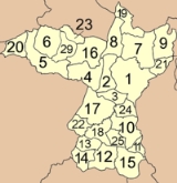
Administrative divisions
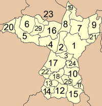
Amphoe
An amphoe is the second level administrative subdivision of Thailand. Usually translated as district, amphoe make up the provinces, and are analogous to a county seat...
). The districts are further subdivided into 198 subdistricts (tambon
Tambon
Tambon is a local government unit in Thailand. Below district and province , they form the third administrative subdivision level. As of the 2009 there are 7255 tambon, not including the 169 khwaeng of Bangkok, which are set at the same administrative level, thus every district contains 8-10 tambon...
) and 2139 villages (muban
Muban
Muban is the lowest administrative subdivision of Thailand. Usually translated as village, they are the subdivision of tambon. As of 2008, there are 74944 administrative villages in Thailand. As of the 1990 census, the average village consisted of 144 households or 746 persons.A muban does not...
).
|
|
|
There are plans to split off the northwestern part to form a new province centered at Phu Wiang. The other districts which will belong to this new province are Nong Ruea, Chum Phae, Si Chomphu, Phu Pha Man, Nong Na Kham and Wiang Kao.
Transportation
Road systemRoad connect to Bangkok and central region by national highway No.2
Road connect to Northern region by national highway No.12
Road connect to Vientiane
Vientiane
-Geography:Vientiane is situated on a bend of the Mekong river, which forms the border with Thailand at this point.-Climate:Vientiane features a tropical wet and dry climate with a distinct monsoon season and a dry season. Vientiane’s dry season spans from November through March. April marks the...
(Laos) via Udonthani and Nong Khai
Nong Khai
Nong Khai is a city in North-East Thailand and is the capital of the Nong Khai Province...
by national highway No.2
Public bus at Khonkaen city
2 Public bus station (locals bus and inter-province bus).
Hourly public bus to Bangkok.
Daily public bus to Major city in northern, central,eastern region.
Railway
Railway system to Bangkok available at Khonkaen railway station.
Air transportation
Air transportation to Bangkok available at Khonkaen airport Khon Kaen Airport
Khon Kaen Airport
Khon Kaen Airport is located in Khon Kaen, Thailand.Serving Khon Kaen, a city strategically important for the region's infrastructure both geographically and economically, the airport was upgraded to international standards in 2005 with the opening of a new terminal. It is located a few kilometers...
(KKC).
Sights
City Pillar Shrine (ศาลเจ้าพ่อเทพารักษ์หลักเมือง) A famous monk and former governor of Khon Kaen placed a stone inscription from an ancient site in Amphoe Chum Phae here for a Buddhism rite and set up the city pillar shrine.Khon Kaen National Museum
Khon Kaen National Museum
The Khon Kaen National Museum was opened by His Majesty King Bhumibol Adulyadej on the 20th of December, 1972. Most of the exhibitions are concerned with history, art, and archaeology...
(พิพิธภัณฑสถานแห่งชาติ ขอนแก่น) The museum exhibits antiques and precious art pieces from pre-historical to historical periods as well as a skeleton of the New Stone Age man and tools found at Ban Chiang.
Bueng Kaen Nakhon (บึงแก่นนคร) The lake is in the municipality of Amphoe Mueang. By the lake is a monument of Chao Phia Mueang Phaen, founder of Khon Kaen.
Treasure Hall (โฮงมูนมังเมืองขอนแก่น) Established to strengthen the local identity and serve as a study centre, the local museum exhibits the history of the city as well as the people’s lifestyle from the yesteryears through the contribution of senior citizens.
Phra Mahathat Kaen Nakhon
Phra Mahathat Kaen Nakhon
Phra Mahathat Kaen Nakhon, Kaen Nakhon, 'The Great Buddha's Relics' or 'The Nine Story Stupa Located in Wat Nong Waeng,' is a Thai royal temple of the old town. Wat Nong Waeng is located close to Kaen Nakhon marsh on Klangmuang Road, Muang District...
or The 9-storey stupa (พระมหาธาตุแก่นนคร หรือพระธาตุ ๙ ชั้น) The Phra Mahathat houses relics of the Lord Buddha and important Buddhist scriptures. Murals within the stupa feature history of the town. The top floor, on the 9th storey, houses relics of the Lord Buddha.
Khon Kaen University (มหาวิทยาลัยขอนแก่น) The university is the largest education centre in Isan, particularly on the areas that directly involve and benefit Isan people.
Art and Cultural Centre (หอศิลปวัฒนธรรม) Located in the compound of Khon Kaen University, the Isan barn-style building features local knowledge in different areas; namely, arts, geography and history through a modern display.
Sim Isan (Wat Pa Saeng Arun) (สิมอีสาน) The Sim Isan’s outstanding features lie in its typical shape and style, solidity, shelter as well as beauty of the murals of Mudmi patterns of the province’s famous tie-dyed silk. This has been intended for later generations to learn, treasure as well as conserve local architecture.
Wat Chai Si and Its Murals (วัดไชยศรีและฮูปแต้มสินไซ) The temple being of archaeological, historical as well as social environmental importance, was declared a national ancient monument on 20 August 2001. The ordination hall – Sim or Ubosot – of this temple houses magnificent mural paintings, both inside and outside, by a folk artisan from Maha Sarakham known as Thong Thipcha.
Huean Lao (เฮือนลาว) The private museum features Isan lifestyle, typical house, local wisdom, native arts and culture in the past.
Phrathat Kham Kaen (พระธาตุขามแก่น) The Phrathat is believed to be the origin of Khon Kaen city since ancient times. Phrathat Kham Kaen can be date the 20th century A.D. The Phrathat is now well renovated and landscaped. A celebration is held annually on the full moon day of the 6th lunar month.
Ku Prapha Chai or Ku Ban Na Kham Noi (กู่ประภาชัย หรือ กู่บ้านนาคำน้อย) According to archaeological finds, the Khmer ruins were hospital built during the reign of Jayavarman VII in the 13th century. The principal tower has a square plan with a front porch, with a rectangular building known as ‘Bannalai’- a library – in the southeast. These two laterite buildings were surrounded in by a stone wall with a single front entrance on the east.
King Cobra Village (หมู่บ้านงูจงอาง) Ban Khok Sa-nga in Tambon Sai Mun is famous for its strange pets, king cobra, kept at every house.
Prem Tinsulanonda Military Fort and Hall of Honour (ค่ายเปรมติณสูลานนท์ และหอเกียรติยศรัฐบุรุษ พลเอกเปรม ติณสูลานนท์) The hall of honour features the biography and achievement of statesman Gen. Prem Tinsulanonda who devoted himself for developing Thailand in different areas.
Ubolratana Dam or Phong Nip Dam (เขื่อนอุบลรัตน์ หรือ เขื่อนพองหนีบ) Ubolratana dam plays significant roles in generating electricity, fishery, irrigation, flood prevention, transportation, and recreation for the people of Khon Kaen.
Wat Phra Phutthabat Phu Phan Kham (วัดพระพุทธบาทภูพานคำ) The temple has a white gigantic Buddha image called Luangpho Yai or Luangpho Khao, of 14 m in height.
Bang Saen II and Hat Chom Thong (บางแสน 2 และหาดจอมทอง) As part of the lake over Ubolratana Dam, the beaches are quite picturesque particularly when the sun sets behind the mountain ranges.
Phu Kao-Phu Phan Kham National Park (อุทยานแห่งชาติภูเก้า-ภูพานคำ) The park acquires a total area of 320 square kilometres or 201,250 rai, in Amphoe Ubolratana and Amphoe Non Sang of Nong Bua Lam Phu province. Most area is deciduous dipterocarp forest, which always changes its hue by early November.
Nam Phong National Park (อุทยานแห่งชาติน้ำพอง) The deciduous dipterocarp and dry everygreen forests in this mountain range are a major source of herbs. There are viewpoints in the park. ‘Hin Chang Si’ is a group of rocks, where wild elephants use for scratching their flanks. This point has a scenic view of the Uboltatana lake and Khon Kaen city.
Phu Wiang Dinosaur Museum (พิพิธภัณฑ์ไดโนเสาร์ภูเวียง) is part of the Phu Wiang Dinosaur Fossil Study and Research Centre. The museum building is divided into three sections: service, academic, and exhibition. The exhibition room displays the Earth’s origin, rocks, minerals, fossils, dinosaur models, etc.
Phu Wiang National Park (อุทยานแห่งชาติภูเวียง) This national park always reminds tourists about dinosaurs. Besides fossils of dinosaurs, there are also traces of ancient civilizations in this area including a high relief of the reclining Buddha on the cliff, at the crest of Phu Wiang Mountain.
Non Mueang Ancient Town (เมืองโบราณโนนเมือง) Archaeologists have found sandstone Sema boundary markers in Dvaravati style in the town and nearby. Archaeologists found that there used to be a human settlement here since the late pre historic period.
Phu Pha Man National Park (อุทยานแห่งชาติภูผาม่าน) The obvious natural landmark of this park is the towering limestone cliff that looks like a huge curtain. Lush jungle and mixed forest keep this place cool almost all the year round.
Tham KlangKhao The cave’s entrance is some 100 metres above ground level. Inside is the habitat of millions of bats, whose accumulated droppings cause a strong smell.
Tham Phra (ถ้ำพระ) Near to Tham Klangkhao, this cave has a natural tunnel sloping up to the crest of Phu Pha Man, but it is quite difficult to get through. The cave houses beautiful stalagmites, stalactites, and big stone pillars.
Tham Pu Ta Lo (ถ้ำภูตาหลอ) The cave is in Ban Wang Sawap, 17 kilometres from downtown Amphoe Phu Pha Man.
Namtok Tat Fa (น้ำตกตาดฟ้า) Tat Fa creek, natural borderline between Amphoe Phu Pha Man of Khon Kaen and Amphoe Nam Nao of Phetchabun, cascades through five steps to form this waterfall. The last step is the most impressive one with a height of 80 metres.
Namtok Tat Yai (น้ำตกตาดใหญ่) The big waterfall originate from Tat Fa Creek. The creek cascades through small waterfalls before going through a big cliff at 80 metres high. Namtok Tat Yai is the highest waterfall in the park.
Namtok Tat Rong (น้ำตกตาดร้อง) With a height of 60–70 metres, the waterfall originates from Phong River that runs from Phu Kradueng. A folk tale says the waterfall can sing as water runs upon a piece of thin stone, the falling water veers off into different rock holes nearby and fills the forest with strange sounds.
Tham Phaya Nakharat (ถ้ำพญานาคราช) As winding as a giant naga, the one-kilometre long cave is naturally decorated with glittering curtain-like stalagmites and stalactites.
Tham Lai Thaeng (ถ้ำลายแทง) whose wall has ancient paintings on some two-square metre area. The paintings contain some 70 pictures of humans, animals, and others, mirroring culture and life in the pre-historical period dating back to over 2,000 years ago.
Tham Pu Lup (ถ้ำปู่หลุบ) Its five chambers are all decorated with glittering stalagmites and stalactites. The cave contains water the year round.
Pha Nok Khao (ผานกเค้า) The towering cliff of black rock by the Phong River looks like an owl or Nok khao in Thai.
Chang Kra (ช้างกระ) Having grown wild over a century ago in Wat Pa Mancha Khiri over 4,000 Chang Kra orchid-Rhyncostylis gigantean (Lindl.) Ridl.-are in full bloom on the branches of some 280 trees every year during January and February. These wild orchids always fill the whole area with their mild fragrance.
Tortoise Village (หมู่บ้านเต่า) The villagers keep a large amount of tortoises as their mutual pets. The brownish yellow shelled tortoises, called Tao Phek in local dialect, always travel around in the village to be fed.
Sim (ubosot of Wat Sa Thong Ban Bua (สิม (โบสถ์) วัดสระทองบ้านบัว) This Sim, ordination hall, is architectural heritage of Isan with outstanding local characters. The Sim houses a rare Isan-style sandstone Buddha image. In 2002, the Sim was awarded a precious architecture, heritage and cultural conservation of the Asia Pacific by UNESCO.
Wat Udom Khongkha Khiri Khet (วัดอุดมคงคาคิรีเขต) Good for meditation practicing, the temple is located deep in lush forest in Tambon Ban Khok. Luangpu Phang, a Buddhist monk famous in meditation, once lived here.
Sala Mai Thai (ศาลาไหมไทย)
Sala Mai Thai is part of the project to celebrate the 60th birtday anniversary of Her Majesty the Queen (August 12, 1992). The centre feature the silk production process from dyeing to weaving, tools for silk production and rare equipment, and different ancient silk textiles various pattern.
Prasat Pueai Noi or Phrathat Ku Thong (ปราสาทเปือยน้อย หรือ พระธาตุกู่ทอง) Prasat Pueai Noi was built in the 11-12th century in a mixed style between Baphuon and Angkor Wat as a shrine honouring Hindu Gods. The Naga was delicately carved on the gable of the main prang whose stone lintel featuring a reclining Narayana or visanu remains in good condition.
Wat Sa Bua Kaeo (วัดสระบัวแก้ว) Crouching guardian lion replicas are on both sides of the stairway leading up to the Ubosot, ordination hall, with sculptures of men stretching their legs in front in front. Luangpho Phui, preceptor of the temple, created all of these sculptures. Murals on four walls of this concrete ordination hall, both exterior and interior, feature the people’s lifestyle, history of the Lord Buddha, heaven and hell and folklore.
Scientific Centre for Education, Khon Kaen Province (ศูนย์วิทยาศาสตร์เพื่อการศึกษาจังหวัดขอนแก่น) The 2-storey building has various exhibitions regarding science and environment as well as the Scientist Princess Room which features history and performances of Prof. Dr. Princess Chulabhorn and the Primeval World Room which features dinosaur and fossils.
Local products
MudmeeIkat
Ikat, or Ikkat, is a dyeing technique used to pattern textiles that employs a resist dyeing process similar to tie-dye on either the warp or weft fibres....
Silk of Chonnabot (ผ้าไหมมัดหมี่ อำเภอชนบท) Handed down from generation to generation, Mudmee is a unique technique of Isan in creating textile pattern. Silk threads are tied and dyed in particular patterns, resulting in beautiful textile patterns.
Mudmee Cotton at Ban Mueang Phia, Amphoe Ban Phai (ผ้าฝ้ายมัดหมี่ บ้านเมืองเพีย อำเภอบ้านไผ่) In most households, weaving a Mudmee cotton and mudmee silk tube skirt is quite a common business here.
Natural-dyed hand-woven cotton (ผ้าฝ้ายทอมือย้อมสีธรรมชาติ) The cotton textile is a famous product by the Art Centre for Developing Isan Women.
Festivals
The Festival of Dok Khun Siang Khaen and Khao Niao Road (เทศกาลดอกคูณเสียงแคนและถนนข้าวเหนียว) The provincial festival of Khon Kaen is held annually during 13–15 April to celebrate the Songkran festival or water splashing. Around Kaen Nakhon Lake and on Si Chan Road, the people of Khon Kaen always start their celebration with donation of food to the monks, ritual bathing of a Buddha image, and blessing elders. Local performances will be held to entertain all fair goers.Phrathat Kham Kaen Fair (เทศกาลไหว้พระธาตุขามแก่น) The fair takes place at Wat Chetiyaphum where Phrathat Kham Kaen is situated on the full-moon day of the sixth lunar month. The fair is intended for the people of Khon Kaen to pay homage to the much revered Phrathat as well as for them to have something to rely on spiritually and make merit.
Silk Festival, Phuk Sieo Tradition and Red Cross Fair (งานเทศกาลไหม ประเพณีผูกเสี่ยวและงานกาชาด) The annual fair is held during 29 November to 10 December of each year right in front of the city hall. Besides growing rice, silk production is a main source of extra income among people in the Northeast, and Khon Kaen today can be called a major silk production centre. ‘Phuk Sieo’ is a native tradition of Northeast to tighten friendship. vi
External links
- Official website of province (Thai only)