

Amphoe Khao Kho
Encyclopedia
Khao Kho is a district (Amphoe
) of Phetchabun Province
, northern Thailand
.
and the Royal Thai Army. It was established as a minor district (King Amphoe) on August 21, 1984, by splitting the two tambon Thung Samo and Khaem Son from Lom Sak district
. It was upgraded to a full district on July 19 1991.
 Neighboring districts are (from the east clockwise) Lom Kao
, Lom Sak
and Mueang Phetchabun
of Phetchabun Province, Noen Maprang
, Wang Thong
and Nakhon Thai
of Phitsanulok Province
, and Dan Sai
of Loei Province
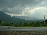
. The Phetchabun Mountains
are a mountain chain in Khao Kho.
The district is subdivided into 7 subdistricts (tambon
), which are further subdivided into 72 villages (muban
). There are no municipal areas (thesaban
) within the district, and 5 Tambon administrative organizations (TAO).
Amphoe
An amphoe is the second level administrative subdivision of Thailand. Usually translated as district, amphoe make up the provinces, and are analogous to a county seat...
) of Phetchabun Province
Phetchabun Province
Phetchabun is one of the northern provinces of Thailand. Neighboring provinces are Loei, Khon Kaen, Chaiyaphum, Lopburi, Nakhon Sawan, Phichit and Phitsanulok.- Geography :...
, northern Thailand
Thailand
Thailand , officially the Kingdom of Thailand , formerly known as Siam , is a country located at the centre of the Indochina peninsula and Southeast Asia. It is bordered to the north by Burma and Laos, to the east by Laos and Cambodia, to the south by the Gulf of Thailand and Malaysia, and to the...
.
Etymology
The name of the district comes from the a kind of palm tree named Kho (Livistona speciosa), that is found a lot in the area, and from the name Khao, mountain. Thus the full name of the district means "Palm tree hills".History
Between 1965-1984, this mountainous area was the battle field of the Thai communist partyCommunist Party of Thailand
The Communist Party of Thailand - CPT was a Marxist-Leninist, Communist political party in Thailand, active from 1942 until the 1990s. Initially known as Communist Party of Siam the party was founded officially on the 1st of December 1942, although communist activism in the country began as early...
and the Royal Thai Army. It was established as a minor district (King Amphoe) on August 21, 1984, by splitting the two tambon Thung Samo and Khaem Son from Lom Sak district
Amphoe Lom Sak
Lom Sak is a district in the northern part of Phetchabun Province, northern Thailand.-History:The history of Lom Sak area dates back to the founding time of the Sukhothai kingdom in the 13th century. The governor of Mueang Rat , Pho Khun Pha Mueang , was one of Thai warlords who defeated the...
. It was upgraded to a full district on July 19 1991.
Geography
Amphoe Lom Kao
Lom Kao is the northernmost district of Phetchabun Province, northern Thailand.-History:The first record of Mueang Lom found in the first King Ram Khamhaeng the Great the Great stone pillar. In Rattanakosin era, this area was a big community of Lao people from Vientiane...
, Lom Sak
Amphoe Lom Sak
Lom Sak is a district in the northern part of Phetchabun Province, northern Thailand.-History:The history of Lom Sak area dates back to the founding time of the Sukhothai kingdom in the 13th century. The governor of Mueang Rat , Pho Khun Pha Mueang , was one of Thai warlords who defeated the...
and Mueang Phetchabun
Amphoe Mueang Phetchabun
Mueang Phetchabun is the capital district of Phetchabun Province, northern Thailand.-History:Mueang Phetchabun was an ancient frontier city, established in Sukhothai era. Prince Damrong Rajanubhab found the old forts on the both banks of the Pa Sak River, same landscaping as Mueang Phitsanulok...
of Phetchabun Province, Noen Maprang
Amphoe Noen Maprang
Noen Maprang is the southernmost district of Phitsanulok Province, northern Thailand.-History:To better cope with the problems caused by communist insurgents in northern Thailand in the 1970s, the government separated Tambon Noen Maprang from Wang Thong district to create a minor district on...
, Wang Thong
Amphoe Wang Thong
Wang Thong is a district of Phitsanulok Province, northern Thailand.-History:The district was established in 1895 in the name Nakhon Pa Mak district after the name of the central tambon, with the district office located at Ban Sam Ruen...
and Nakhon Thai
Amphoe Nakhon Thai
Nakhon Thai is a district in the eastern part of Phitsanulok Province, northern Thailand.-Geography:Neighboring districts are Wang Thong, Chat Trakan of Phitsanulok Province, Na Haeo, Dan Sai of Loei Province and Khao Kho of Phetchabun Province.The Phu Hin Rong Kla National Park is located in...
of Phitsanulok Province
Phitsanulok Province
Phitsanulok is a provinces of Thailand, located in the north. Neighboring provinces are Loei, Phetchabun, Phichit, Kamphaeng Phet, Sukhothai, Uttaradit. In the north-east it also has a short border with Xaignabouli of Laos....
, and Dan Sai
Amphoe Dan Sai
Dan Sai is a district in the western part of Loei Province, northeastern Thailand.-Geography:Neighboring districts are Phu Ruea of Loei Province, Lom Kao and Khao Kho of Phetchabun Province, Nakhon Thai of Phitsanulok Province, and Na Haeo of Loei again...
of Loei Province
Loei Province
Loei is one of the most sparsely populated provinces of Thailand, located in the North-East. Neighboring provinces are Nong Khai, Udon Thani, Nongbua Lamphu, Khon Kaen, Phetchabun, Phitsanulok...
. The Phetchabun Mountains
Phetchabun Mountains
The Phetchabun mountains are a mountain range in Thailand.-Geography:It extends in a roughly north-south direction, and separates the broad Chao Phraya river valley of central Thailand from the Khorat Plateau of northeast Thailand...
are a mountain chain in Khao Kho.
Administration
The district is subdivided into 7 subdistricts (tambon
Tambon
Tambon is a local government unit in Thailand. Below district and province , they form the third administrative subdivision level. As of the 2009 there are 7255 tambon, not including the 169 khwaeng of Bangkok, which are set at the same administrative level, thus every district contains 8-10 tambon...
), which are further subdivided into 72 villages (muban
Muban
Muban is the lowest administrative subdivision of Thailand. Usually translated as village, they are the subdivision of tambon. As of 2008, there are 74944 administrative villages in Thailand. As of the 1990 census, the average village consisted of 144 households or 746 persons.A muban does not...
). There are no municipal areas (thesaban
Thesaban
Thesaban are the municipalities in Thailand. There are three levels of municipalities - city, town and subdistrict municipality. Both Bangkok and Pattaya are special municipal entities outside the thesaban system....
) within the district, and 5 Tambon administrative organizations (TAO).
| No. | Name | Thai name | Villages | Inh. Population A population is all the organisms that both belong to the same group or species and live in the same geographical area. The area that is used to define a sexual population is such that inter-breeding is possible between any pair within the area and more probable than cross-breeding with individuals... |
|
|---|---|---|---|---|---|
| 1. | Thung Samo | ทุ่งสมอ | 11 | 4,013 | |
| 2. | Khaem Son | แคมป์สน | 14 | 5,284 | |
| 3. | Khao Kho | เขาค้อ | 14 | 6,467 | |
| 4. | Rim Si Muang | ริมสีม่วง | 6 | 1,293 | |
| 5. | Sado Phong | สะเดาะพง | 5 | 1,432 | |
| 6. | Nong Mae Na | หนองแม่นา | 10 | 2,594 | |
| 7. | Khek Noi | เข็กน้อย | 12 | 11,849 |