
Phu Hin Rong Kla National Park
Encyclopedia
Phu Hin Rong Kla National Park is a national park located in the Loei
, Phitsanulok
and Phetchabun
Provinces of Thailand
.
. The Southern part of the park extends into the Phetchabun Province
. Mountain peaks include Phu Phangma, Phu Lomlo, Phu Hin Rong Kla and Phu Man Khao. Phu Man Kaho is the tallest peak in the park, with an elevation of 1,820 meters. The second tallest is Phu Lomlo at an elevation of 1,664 meters. Within the park are the sources of the Mueat Don and Luang Yai Rivers.
s, moss
, lichens and seasonal flowers.
Loei Province
Loei is one of the most sparsely populated provinces of Thailand, located in the North-East. Neighboring provinces are Nong Khai, Udon Thani, Nongbua Lamphu, Khon Kaen, Phetchabun, Phitsanulok...
, Phitsanulok
Phitsanulok Province
Phitsanulok is a provinces of Thailand, located in the north. Neighboring provinces are Loei, Phetchabun, Phichit, Kamphaeng Phet, Sukhothai, Uttaradit. In the north-east it also has a short border with Xaignabouli of Laos....
and Phetchabun
Phetchabun Province
Phetchabun is one of the northern provinces of Thailand. Neighboring provinces are Loei, Khon Kaen, Chaiyaphum, Lopburi, Nakhon Sawan, Phichit and Phitsanulok.- Geography :...
Provinces of Thailand
Thailand
Thailand , officially the Kingdom of Thailand , formerly known as Siam , is a country located at the centre of the Indochina peninsula and Southeast Asia. It is bordered to the north by Burma and Laos, to the east by Laos and Cambodia, to the south by the Gulf of Thailand and Malaysia, and to the...
.
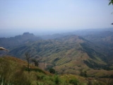
Topography
The park landscape is generally steep mountains. The northern part of the park in stretches to the border with LaosLaos
Laos Lao: ສາທາລະນະລັດ ປະຊາທິປະໄຕ ປະຊາຊົນລາວ Sathalanalat Paxathipatai Paxaxon Lao, officially the Lao People's Democratic Republic, is a landlocked country in Southeast Asia, bordered by Burma and China to the northwest, Vietnam to the east, Cambodia to the south and Thailand to the west...
. The Southern part of the park extends into the Phetchabun Province
Phetchabun Province
Phetchabun is one of the northern provinces of Thailand. Neighboring provinces are Loei, Khon Kaen, Chaiyaphum, Lopburi, Nakhon Sawan, Phichit and Phitsanulok.- Geography :...
. Mountain peaks include Phu Phangma, Phu Lomlo, Phu Hin Rong Kla and Phu Man Khao. Phu Man Kaho is the tallest peak in the park, with an elevation of 1,820 meters. The second tallest is Phu Lomlo at an elevation of 1,664 meters. Within the park are the sources of the Mueat Don and Luang Yai Rivers.
Climate
The park is generally cool all year round, with temperatures rarely rising above 25° Celsius. The temperature occasionally drops below freezing.Animal Species
Among the species of animal in the park are:- TigerTigerThe tiger is the largest cat species, reaching a total body length of up to and weighing up to . Their most recognizable feature is a pattern of dark vertical stripes on reddish-orange fur with lighter underparts...
- LeopardLeopardThe leopard , Panthera pardus, is a member of the Felidae family and the smallest of the four "big cats" in the genus Panthera, the other three being the tiger, lion, and jaguar. The leopard was once distributed across eastern and southern Asia and Africa, from Siberia to South Africa, but its...
- Asiatic Black BearAsiatic Black BearThe Asian black bear , also known as the moon bear or white-chested bear is a medium-sized species of bear, largely adapted for arboreal life, which occurs through much of southern Asia, Korea, northeastern China, the Russian far east and Honshū and Shikoku islands of Japan...
- Wild boar
- FoxFoxFox is a common name for many species of omnivorous mammals belonging to the Canidae family. Foxes are small to medium-sized canids , characterized by possessing a long narrow snout, and a bushy tail .Members of about 37 species are referred to as foxes, of which only 12 species actually belong to...
- MonkeyMonkeyA monkey is a primate, either an Old World monkey or a New World monkey. There are about 260 known living species of monkey. Many are arboreal, although there are species that live primarily on the ground, such as baboons. Monkeys are generally considered to be intelligent. Unlike apes, monkeys...
- Leopard catLeopard CatThe leopard cat is a small wild cat of South and East Asia. Since 2002 it has been listed as Least Concern by IUCN as it is widely distributed but threatened by habitat loss and hunting in parts of its range...
s - Wild hareHareHares and jackrabbits are leporids belonging to the genus Lepus. Hares less than one year old are called leverets. Four species commonly known as types of hare are classified outside of Lepus: the hispid hare , and three species known as red rock hares .Hares are very fast-moving...
- Boves barbets
- Common FlamebackCommon FlamebackThe Common Flameback or Common Goldenback is a species of bird in the Picidae family. It is found in Bangladesh, Brunei, Cambodia, China, India, Indonesia, Laos, Malaysia, Myanmar, the Philippines, Singapore, Thailand, and Vietnam.-Description and ecology:A medium-sized, golden-backed woodpecker...
- Asian Barred OwletAsian Barred OwletThe Asian Barred Owlet is a species of true owl, resident in northern South Asia and SE Asia . Its natural habitat is temperate forest....
- Brown Hawk-owl
- Jungle fowl
- BulbulBulbulBulbuls are a family, Pycnonotidae, of medium-sized passerine songbirds. Many forest species are known as greenbuls. The family is distributed across most of Africa and into the Middle East, tropical Asia to Indonesia, and north as far as Japan. A few insular species occur on the tropical islands...
s - SwallowSwallowThe swallows and martins are a group of passerine birds in the family Hirundinidae which are characterised by their adaptation to aerial feeding...
s
Rock Formations
The park contains Lan Hin Taek, natural rock formations covered with orchids, fernFern
A fern is any one of a group of about 12,000 species of plants belonging to the botanical group known as Pteridophyta. Unlike mosses, they have xylem and phloem . They have stems, leaves, and roots like other vascular plants...
s, moss
Moss
Mosses are small, soft plants that are typically 1–10 cm tall, though some species are much larger. They commonly grow close together in clumps or mats in damp or shady locations. They do not have flowers or seeds, and their simple leaves cover the thin wiry stems...
, lichens and seasonal flowers.