

Phetchabun Mountains
Encyclopedia
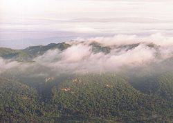
Mountain range
A mountain range is a single, large mass consisting of a succession of mountains or narrowly spaced mountain ridges, with or without peaks, closely related in position, direction, formation, and age; a component part of a mountain system or of a mountain chain...
in Thailand
Thailand
Thailand , officially the Kingdom of Thailand , formerly known as Siam , is a country located at the centre of the Indochina peninsula and Southeast Asia. It is bordered to the north by Burma and Laos, to the east by Laos and Cambodia, to the south by the Gulf of Thailand and Malaysia, and to the...
.
Geography

Central Thailand
Central Thailand is a region of Thailand, covering the broad alluvial plain of the Chao Phraya River. It is separated from North-East Thailand by the Phetchabun mountain range, and another mountain range separates it from Myanmar to the west. In the north it gently changes into the more hilly...
from the Khorat Plateau
Khorat Plateau
The Khorat Plateau also Korat Plateau, is a plateau in the northeastern region of Thailand, named for the short form of Nakhon Ratchasima, an historical stronghold controlling access to and from the plateau.-Geography:...
of northeast Thailand
Isan
Isan is the northeastern region of Thailand. It is located on the Khorat Plateau, bordered by the Mekong River to the north and east, by Cambodia to the southeast and the Prachinburi mountains south of Nakhon Ratchasima...
. The mountain range is named after the city of Phetchabun
Phetchabun
Phetchabun is a town in Thailand, capital of the Phetchabun Province. It covers the tambon Nai Mueang of the Phetchabun district, along the Pa Sak River...
which is located in the mountains.
The highest elevation of the Phetchabun mountains is at 1820 m above sea level at the Phu Hin Rong Kla National Park
Phu Hin Rong Kla National Park
Phu Hin Rong Kla National Park is a national park located in the Loei, Phitsanulok and Phetchabun Provinces of Thailand.-Topography:The park landscape is generally steep mountains. The northern part of the park in stretches to the border with Laos. The Southern part of the park extends into the...
in the northern part of the mountain range. It consists of two parallel mountain chains, with the valley of the river Pa Sak in the middle. To the south the mountains end in the Khao Yai national park
Khao Yai National Park
Khao Yai National Park is a national park in Thailand.-Description:Khao Yai National Park is situated in the Sankamphaeng Mountain Range, the southern prolongation of the Dong Phaya Yen Mountains, at the southwestern boundary of the Khorat Plateau....
, and are continued to the east by the Dong Phaya Yen
Dong Phaya Yen mountains
Dong Phaya Yen is a mountain range in central Thailand.-Description:Dong Phaya Yen is the southeastern extension of the Phetchabun mountains, dividing the Chao Phraya river valley of Central Thailand and the Khorat Plateau of the northeast...
, Sankambeng and Phnom-Dongrek mountain chains.
Geologically
Geology
Geology is the science comprising the study of solid Earth, the rocks of which it is composed, and the processes by which it evolves. Geology gives insight into the history of the Earth, as it provides the primary evidence for plate tectonics, the evolutionary history of life, and past climates...
, the mountains consist of limestone
Limestone
Limestone is a sedimentary rock composed largely of the minerals calcite and aragonite, which are different crystal forms of calcium carbonate . Many limestones are composed from skeletal fragments of marine organisms such as coral or foraminifera....
, interfused with slate
Slate
Slate is a fine-grained, foliated, homogeneous metamorphic rock derived from an original shale-type sedimentary rock composed of clay or volcanic ash through low-grade regional metamorphism. The result is a foliated rock in which the foliation may not correspond to the original sedimentary layering...
and sandstone
Sandstone
Sandstone is a sedimentary rock composed mainly of sand-sized minerals or rock grains.Most sandstone is composed of quartz and/or feldspar because these are the most common minerals in the Earth's crust. Like sand, sandstone may be any colour, but the most common colours are tan, brown, yellow,...
. A few igneous rock
Igneous rock
Igneous rock is one of the three main rock types, the others being sedimentary and metamorphic rock. Igneous rock is formed through the cooling and solidification of magma or lava...
s are also found: granite
Granite
Granite is a common and widely occurring type of intrusive, felsic, igneous rock. Granite usually has a medium- to coarse-grained texture. Occasionally some individual crystals are larger than the groundmass, in which case the texture is known as porphyritic. A granitic rock with a porphyritic...
, basalt
Basalt
Basalt is a common extrusive volcanic rock. It is usually grey to black and fine-grained due to rapid cooling of lava at the surface of a planet. It may be porphyritic containing larger crystals in a fine matrix, or vesicular, or frothy scoria. Unweathered basalt is black or grey...
and porphyry
Porphyry (geology)
Porphyry is a variety of igneous rock consisting of large-grained crystals, such as feldspar or quartz, dispersed in a fine-grained feldspathic matrix or groundmass. The larger crystals are called phenocrysts...
.
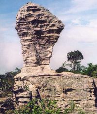
Strange rock formations and fields where the Siam Tulip
Siam Tulip
The Siam Tulip or Summer Tulip is a tropical plant native to northern Thailand and Cambodia. Despite its name, it is not related to the tulip, but to the various ginger species such as turmeric...
flower (Curcuma alismatifolia), known as dok krachiao (ดอกกระเจียว) in Thai
Thai language
Thai , also known as Central Thai and Siamese, is the national and official language of Thailand and the native language of the Thai people, Thailand's dominant ethnic group. Thai is a member of the Tai group of the Tai–Kadai language family. Historical linguists have been unable to definitively...
, grows wild are some of the characteristics of the Phetchabun Mountains.
History
Until recently the mountains formed a barrier between the two parts of Thailand - only the railroad from BangkokBangkok
Bangkok is the capital and largest urban area city in Thailand. It is known in Thai as Krung Thep Maha Nakhon or simply Krung Thep , meaning "city of angels." The full name of Bangkok is Krung Thep Mahanakhon Amon Rattanakosin Mahintharayutthaya Mahadilok Phop Noppharat Ratchathani Burirom...
to Nakhon Ratchasima
Nakhon Ratchasima
Nakhon Ratchasima or is a city in the north-east of Thailand and gateway to Isan. It is the capital of the Nakhon Ratchasima Province and Nakhon Ratchasima district...
and one highway crossed it.
Before the construction of the railroad in the beginning of the 20th century, the separation of the two parts of the country was even more distinct.
During the period between 1968-1982 the area around Khao Kho (เขาค้อ) became an occasional battleground. At that time communist insurgents established their base in hidden mountain locations and fought skirmishes against the Thai Army.
Protected areas
Several national parks, forest parks and wildlife reserves are located in these mountains. In 2005 these were accepted by the UNESCOUNESCO
The United Nations Educational, Scientific and Cultural Organization is a specialized agency of the United Nations...
as a possible future addition to the World Heritage list.
These sites include:
- Nam Nao National ParkNam Nao National ParkNam Nao National Park is located in Nam Nao District, Phetchabun Province in northern Thailand. It is situated west of Amphoe Lom Sak. The park is a large forest still in its original state. It is filled with pineries, grasslands and virgin ungles. The park is home to more than 100 species of...
- Pa Hin Ngam National ParkPa Hin Ngam National ParkPa Hin Ngam is a National Park in Chaiyaphum province in Thailand. The name Hin Ngam means beautiful stone, where Pa means forest....
, located at the boundary of the Phetchabun mountain range with the Khorat PlateauKhorat PlateauThe Khorat Plateau also Korat Plateau, is a plateau in the northeastern region of Thailand, named for the short form of Nakhon Ratchasima, an historical stronghold controlling access to and from the plateau.-Geography:...
. - Phu Hin Rong Kla National ParkPhu Hin Rong Kla National ParkPhu Hin Rong Kla National Park is a national park located in the Loei, Phitsanulok and Phetchabun Provinces of Thailand.-Topography:The park landscape is generally steep mountains. The northern part of the park in stretches to the border with Laos. The Southern part of the park extends into the...
- Phu Khiao Wildlife Sanctuary
- Phu Kradung National ParkPhu Kradung National ParkPhu Kradueng National Park , located in Amphoe Phu Kradueng of Loei Province, is one of the most famous national parks of Thailand, with a high point of 1316 m above sea level. Every year tens of thousands of people come to make the climb up this famous mountain...
- Phu Luang Wildlife SanctuaryPhu Luang Wildlife SanctuaryPhu Luang Wildlife Sanctuary is a wildlife sanctuary in northern Thailand, located in the south of Loei Province.It covers an area of 897 km², covering area of the tambon Pla Ba and Tha Sala of Phu Ruea district, Phon Sung, Wang Yao and I Pum of Dan Sai, Nong Ngio and Saikhao of Wang Saphung, and...
- Thung Salaeng Luang National ParkThung Salaeng Luang National ParkThung Salaeng Luang National Park is a national park located in the Phitsanulok and Phetchabun Provinces of Thailand. It encompasses substantial portions of Amphoe Wang Thong and Amphoe Lom Sak.-Topography:...
Besides these, some forest parks are also included.