
Grand Combin
Encyclopedia
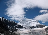
The Grand Combin is a mountain in the western Pennine Alps
in Switzerland
. With its 4314 metres (14,154 ft) high summit it is one of the highest peaks in the Alps
and the second most prominent of its range. The Grand Combin is also a large glaciated massif
consisting of several summits, among which three are above 4000 metres.
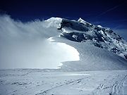
The normal route starts from the Panossière Hut, which lies on the north side in the Corbassière
valley. Despite the fact that no major difficulties exist, a particularly dangerous passage has to be traversed on the north flank: Le Corridor. It is a couloir dominated by seracs continuously falling on it.
 The massif of the Grand Combin lies south of Verbier
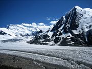
between the Val d'Entremont (west) and Val de Bagnes (west). The north-western facing side of Grand Combin is entirely covered by eternal snows and glaciers which are prone to serac
falls. The southern and eastern walls are more steep and thus exempt of snow.
The topography of the Grand Combin is intricate. Between the Val d'Entremont and the Val de Bagnes are two high ridges, nearly parallel to each other and to those valleys, which both diverge from a short transverse ridge of great height. The southern end of the space enclosed between these three ridges is an elevated plateau of great extent, where the snows accumulate and feed the Corbassière Glacier
which descends thence for about ten kilometers to the north. The glacier is surrounded by the peaks of Petit Combin
, Combin de Corbassière and Combin de Boveire
on the west, Grand Tavé
and Tournelon Blanc on the east. Smaller glaciers lie on the external flanks such as Boveire
and Mont Durand Glacier
.
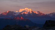
At the south-east extremity of the plateau the highest part of the enclosing ridge is surmounted by two conical summits, of which the higher sout-west point (Grand Combin de Graffeneire) is 4,314 mteres in height, while the neighbouring north-east summit (Aiguille du Croissant
) is lower by less than 60 meters (4,260 metres). Two other minor summits over 4,000 metres are located on the ridge: the Grand Combin de Valsorey (4184 m) on the west and the Combin de la Tsessette
(4135 m) on the east. On the west side, the plateau sinks to a considerably lower level, and over this lies the Col des Maisons Blanches (3,418 m), by which access to the Corbassiere valley is obtained from the side of the Val d'Entremont.
All the waters flowing on the region end up in the Dranse river and the Rhone
. After Dom, Weisshorn
, it is the highest massif of the Alps situated out of the main chain. South of the Grand Combin, the ridge separating the glaciers of Mont Durand and Sonadon reaches the Grande Tête de By
a few kilometres away, which is located on the main watershed
. The ridge diverges to the south-west and appears to be continuous with the range of the Aiguilles Vertes, or Aiguilles de Valsorey, and that of Mont Vélan
. From this branches the lower range, which divides the channel of the Glacier du Mont Durand (north) from the Piedmontese Val d'Ollomont (south), and extends by the Col de Fenêtre to the Mont Gelé
.
 The Grand Combin, which yields in height to only a few European mountains, was long one of the least known of Alpine summits. The first to commence the exploration of the great massif which separates the Val de Bagnes from the Val d'Entremont was Gottlieb Samuel Studer
, of Berne, who on August 14, 1851 reached for the first time the summit of the Combin de Corbassière with the guide Joseph-Benjamin Fellay, and has published an account of that and a subsequent excursion in Bergund Gletscher-Fahrten. He was followed in that ascent five years later by W. and C. E. Mathews, and in 1857, William Mathews
anticipated Studer in the ascent of the second peak of the Grand Combin.
The first four expeditions on Grand Combin reached only the minor summit east of Grand Combin (Aiguille du Croissant). The first one was made by mountain guides from the valley (Maurice Fellay and Jouvence Bruchez) on July 20, 1857. The first complete ascent of Grand Combin was finally made on July 30, 1859 by Charles Sainte-Claire Deville with Daniel, Emmanuel and Gaspard balleys, and Basile Dorsaz.
The Grand Combin de Valsoray on the west was reached for the first time on 16 September 1872 by J. H. Isler and J. Gillioz. They climbed the south south face above the Plateau du Couloir. The itinerary on the south-east ridge was opened on 10 September 1891 by O. Glynne Jones, A.Bovier and P. Gaspoz.
Pennine Alps
The Pennine Alps are a mountain range in the western part of the Alps. They are located in Switzerland and Italy...
in Switzerland
Switzerland
Switzerland name of one of the Swiss cantons. ; ; ; or ), in its full name the Swiss Confederation , is a federal republic consisting of 26 cantons, with Bern as the seat of the federal authorities. The country is situated in Western Europe,Or Central Europe depending on the definition....
. With its 4314 metres (14,154 ft) high summit it is one of the highest peaks in the Alps
Alps
The Alps is one of the great mountain range systems of Europe, stretching from Austria and Slovenia in the east through Italy, Switzerland, Liechtenstein and Germany to France in the west....
and the second most prominent of its range. The Grand Combin is also a large glaciated massif
Massif
In geology, a massif is a section of a planet's crust that is demarcated by faults or flexures. In the movement of the crust, a massif tends to retain its internal structure while being displaced as a whole...
consisting of several summits, among which three are above 4000 metres.
The normal route starts from the Panossière Hut, which lies on the north side in the Corbassière
Corbassière Glacier
The Corbassière Glacier is a valley glacier in the Grand Combin massif in the Pennine Alps in southwestern Valais. It is long with an average width of slightly more than and covers an area of ....
valley. Despite the fact that no major difficulties exist, a particularly dangerous passage has to be traversed on the north flank: Le Corridor. It is a couloir dominated by seracs continuously falling on it.
Geography
Verbier
Verbier is a village located in southwestern Switzerland in the canton of Valais. It is one of the largest holiday resort and ski areas in the Swiss Alps, is recognized as one of the premiere "off-piste" locations in the world...
between the Val d'Entremont (west) and Val de Bagnes (west). The north-western facing side of Grand Combin is entirely covered by eternal snows and glaciers which are prone to serac
Serac
A serac is a block or column of ice formed by intersecting crevasses on a glacier. Often house-sized or larger, they are dangerous to mountaineers since they may topple with little warning...
falls. The southern and eastern walls are more steep and thus exempt of snow.
The topography of the Grand Combin is intricate. Between the Val d'Entremont and the Val de Bagnes are two high ridges, nearly parallel to each other and to those valleys, which both diverge from a short transverse ridge of great height. The southern end of the space enclosed between these three ridges is an elevated plateau of great extent, where the snows accumulate and feed the Corbassière Glacier
Corbassière Glacier
The Corbassière Glacier is a valley glacier in the Grand Combin massif in the Pennine Alps in southwestern Valais. It is long with an average width of slightly more than and covers an area of ....
which descends thence for about ten kilometers to the north. The glacier is surrounded by the peaks of Petit Combin
Petit Combin
The Petit Combin is a mountain in the Grand Combin massif, in the Pennine Alps....
, Combin de Corbassière and Combin de Boveire
Combin de Boveire
Combin de Boveire is a mountain in the Pennine Alps in Switzerland.-External links:*...
on the west, Grand Tavé
Grand Tavé
Grand Tavé is a mountain in the Pennine Alps in Switzerland.-External links:*...
and Tournelon Blanc on the east. Smaller glaciers lie on the external flanks such as Boveire
Boveire Glacier
The Boveire Glacier is a 2 km long glacier situated in the Pennine Alps in the canton of Valais in Switzerland. In 1973 it had an area of 2.08 km².-External links:*...
and Mont Durand Glacier
Mont Durand Glacier
The Mont Durand Glacier is a 5.9 km long glacier situated in the Grand Combin massif, Pennine Alps, in the canton of Valais in Switzerland. In 1973 it had an area of 7.5 km².-External links:*...
.
At the south-east extremity of the plateau the highest part of the enclosing ridge is surmounted by two conical summits, of which the higher sout-west point (Grand Combin de Graffeneire) is 4,314 mteres in height, while the neighbouring north-east summit (Aiguille du Croissant
Aiguille du Croissant
The Aiguille du Croissant is a minor summit in the Grand Combin massif in the Pennine Alps. Because of its small prominence it was included in the enlarged list of alpine four-thousanders.- External links :*...
) is lower by less than 60 meters (4,260 metres). Two other minor summits over 4,000 metres are located on the ridge: the Grand Combin de Valsorey (4184 m) on the west and the Combin de la Tsessette
Combin de la Tsessette
The Combin de la Tsessette is the third highest summit in the Grand Combin massif. It lies east of the Grand Combin summit....
(4135 m) on the east. On the west side, the plateau sinks to a considerably lower level, and over this lies the Col des Maisons Blanches (3,418 m), by which access to the Corbassiere valley is obtained from the side of the Val d'Entremont.
All the waters flowing on the region end up in the Dranse river and the Rhone
Rhône
Rhone can refer to:* Rhone, one of the major rivers of Europe, running through Switzerland and France* Rhône Glacier, the source of the Rhone River and one of the primary contributors to Lake Geneva in the far eastern end of the canton of Valais in Switzerland...
. After Dom, Weisshorn
Weisshorn
The Weisshorn is a mountain in the Pennine Alps, in Switzerland. With its summit, it is one of the major peaks in the Alps and overtops the nearby Matterhorn by some 30 metres. It was first climbed in 1861 from Randa by John Tyndall, accompanied by the guides J.J...
, it is the highest massif of the Alps situated out of the main chain. South of the Grand Combin, the ridge separating the glaciers of Mont Durand and Sonadon reaches the Grande Tête de By
Grande Tête de By
Grande Tête de By is a mountain in the Pennine Alps on the Swiss-Italian border.-External links:*...
a few kilometres away, which is located on the main watershed
Main chain of the Alps
The Alpine divide is the central line of mountains that forms the water divide of the range. Main chains of mountain ranges are traditionally designated in this way, and generally include the highest peaks of a range; the Alps are something of an unusual case in that several significant groups of...
. The ridge diverges to the south-west and appears to be continuous with the range of the Aiguilles Vertes, or Aiguilles de Valsorey, and that of Mont Vélan
Mont Vélan
Mont Vélan is a mountain in the Pennine Alps, located on the border between Switzerland and Italy. At 3,727, metres Mont Vélan is the highest summit lying between the Great St Bernard Pass and Grand Combin. Two large glaciers cover its northern flanks: Glacier de Tseudet and Glacier de Valsoray...
. From this branches the lower range, which divides the channel of the Glacier du Mont Durand (north) from the Piedmontese Val d'Ollomont (south), and extends by the Col de Fenêtre to the Mont Gelé
Mont Gelé (3518)
Mont Gelé is a mountain in the Pennine Alps on the Swiss-Italian border.-External links:*...
.
Climbing history
Gottlieb Samuel Studer
Gottlieb Samuel Studer was a Swiss mountaineer, Notary public and draughtsman.Studer was the son of Sigmund Gottlieb Studer...
, of Berne, who on August 14, 1851 reached for the first time the summit of the Combin de Corbassière with the guide Joseph-Benjamin Fellay, and has published an account of that and a subsequent excursion in Bergund Gletscher-Fahrten. He was followed in that ascent five years later by W. and C. E. Mathews, and in 1857, William Mathews
William Mathews
William Mathews was an English mountaineer, land agent and surveyor, who first proposed the formation of the Alpine Club of London in 1857.-Founding of the Alpine Club:...
anticipated Studer in the ascent of the second peak of the Grand Combin.
The first four expeditions on Grand Combin reached only the minor summit east of Grand Combin (Aiguille du Croissant). The first one was made by mountain guides from the valley (Maurice Fellay and Jouvence Bruchez) on July 20, 1857. The first complete ascent of Grand Combin was finally made on July 30, 1859 by Charles Sainte-Claire Deville with Daniel, Emmanuel and Gaspard balleys, and Basile Dorsaz.
The Grand Combin de Valsoray on the west was reached for the first time on 16 September 1872 by J. H. Isler and J. Gillioz. They climbed the south south face above the Plateau du Couloir. The itinerary on the south-east ridge was opened on 10 September 1891 by O. Glynne Jones, A.Bovier and P. Gaspoz.