

Weissmies
Encyclopedia
The Weissmies 4017 m is a mountain
in the Pennine
Alps
in the canton of Valais
in Switzerland
near the village of Saas-Fee
. It is the easternmost four-thousander
of its range.
 The Weissmies is located on the main Alpine chain
, on a massif separating the Saastal
valley on the west and Simplon valley on the east. The massif consists of two other main summits lying to the north at almost the same altitude, the Lagginhorn
and Fletschhorn
. The mountain lies between the Lagginjoch (3,500 m) to the north and the Zwischbergen Pass
(3,260 m) to the south.
The Weissmies is one of the 10 four-thousanders surrounding the Saastal
, facing the Dom on the west, the third highest summit of the Alps
.
 It was first climbed by Jakob Christian Häusser and Peter Josef Zurbriggen in 1855 via the Triftgrat. The ascent was mired in some controversy as the local guides did not believe that the peak could be ascended without their help; when they themselves ascended to the summit by following Häusser and Zurbriggen's footprints, they found that the highest point had indeed been reached.
The east face was climbed first by J. A. Peebles, Mr and Mrs E. P. Jackson with guides P. Schlegel, U. Rubi and J. Martin on 17 October 1876. The more difficult south face was climbed in 1884 by C. H. Wilson, A. Burgener, J. Furrer. Two weeks later, W. H. and E. Paine with T. Andenmatten and P. Zurbriggen opened a route on the northern ridge.
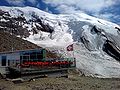
The approach to the Trift Glacier/south-west ridge (Triftgrat) route can now be made via lift to Hohsaas
(3,100 m), which is located virtually at the edge of the glacier
. The ascent from Hohsaas takes about 4 hours and involves slopes to 40 degrees and crevasses. Another route starts from the Zwischbergen Pass
(above Almageller Hut) at the foot of the southern ridge.

Mountain
Image:Himalaya_annotated.jpg|thumb|right|The Himalayan mountain range with Mount Everestrect 58 14 160 49 Chomo Lonzorect 200 28 335 52 Makalurect 378 24 566 45 Mount Everestrect 188 581 920 656 Tibetan Plateaurect 250 406 340 427 Rong River...
in the Pennine
Pennine Alps
The Pennine Alps are a mountain range in the western part of the Alps. They are located in Switzerland and Italy...
Alps
Swiss Alps
The Swiss Alps are the portion of the Alps mountain range that lies within Switzerland. Because of their central position within the entire Alpine range, they are also known as the Central Alps....
in the canton of Valais
Valais
The Valais is one of the 26 cantons of Switzerland in the southwestern part of the country, around the valley of the Rhône from its headwaters to Lake Geneva, separating the Pennine Alps from the Bernese Alps. The canton is one of the drier parts of Switzerland in its central Rhône valley...
in Switzerland
Switzerland
Switzerland name of one of the Swiss cantons. ; ; ; or ), in its full name the Swiss Confederation , is a federal republic consisting of 26 cantons, with Bern as the seat of the federal authorities. The country is situated in Western Europe,Or Central Europe depending on the definition....
near the village of Saas-Fee
Saas-Fee
Saas-Fee is the main village in the Saastal, or the Saas Valley, and is a municipality in the district of Visp in the canton of Valais in Switzerland...
. It is the easternmost four-thousander
Four-thousander
A four-thousander is a mountain summit that is at least 4,000 metres above sea level. Because the highest peaks in Europe fall into this category, the summits of four-thousanders are popular in Europe with climbers and mountaineers as climbing goals...
of its range.
Geography
Main chain of the Alps
The Alpine divide is the central line of mountains that forms the water divide of the range. Main chains of mountain ranges are traditionally designated in this way, and generally include the highest peaks of a range; the Alps are something of an unusual case in that several significant groups of...
, on a massif separating the Saastal
Saastal
The Saastal or the Saas Valley is an alpine valley in the Canton of Valais, Switzerland. It is separated from the Mattertal valley by the Dom....
valley on the west and Simplon valley on the east. The massif consists of two other main summits lying to the north at almost the same altitude, the Lagginhorn
Lagginhorn
The Lagginhorn is a mountain in the Pennine Alps in Switzerland. It lies a few kilometres north of the slightly higher Weissmies and also close to the slightly lower Fletschhorn on the north....
and Fletschhorn
Fletschhorn
The Fletschhorn is a mountain in the Pennine Alps in Switzerland. It lies to the north of the Lagginhorn and the Weissmies in the same massif, to the east of the Saastal....
. The mountain lies between the Lagginjoch (3,500 m) to the north and the Zwischbergen Pass
Zwischbergen Pass
The Zwischbergen Pass is a high mountain pass across the eastern Pennine Alps, connecting Saas Almagell and Zwischbergen in the canton of Valais in Switzerland.The pass lies between the Weissmies on the north and Portjengrat on the South....
(3,260 m) to the south.
The Weissmies is one of the 10 four-thousanders surrounding the Saastal
Saastal
The Saastal or the Saas Valley is an alpine valley in the Canton of Valais, Switzerland. It is separated from the Mattertal valley by the Dom....
, facing the Dom on the west, the third highest summit of the Alps
Alps
The Alps is one of the great mountain range systems of Europe, stretching from Austria and Slovenia in the east through Italy, Switzerland, Liechtenstein and Germany to France in the west....
.
Climbing
The east face was climbed first by J. A. Peebles, Mr and Mrs E. P. Jackson with guides P. Schlegel, U. Rubi and J. Martin on 17 October 1876. The more difficult south face was climbed in 1884 by C. H. Wilson, A. Burgener, J. Furrer. Two weeks later, W. H. and E. Paine with T. Andenmatten and P. Zurbriggen opened a route on the northern ridge.
The approach to the Trift Glacier/south-west ridge (Triftgrat) route can now be made via lift to Hohsaas
Hohsaas
Hohsaas is a cable car station and a ski area in the Pennine Alps above Saas Grund in Valais.Although Hohsaas is not a mountain summit it still offers impressive views over the Dom on the Mischabel range and 18 four-thousand meters mountains, including the Weissmies which is easily accessible from...
(3,100 m), which is located virtually at the edge of the glacier
Glacier
A glacier is a large persistent body of ice that forms where the accumulation of snow exceeds its ablation over many years, often centuries. At least 0.1 km² in area and 50 m thick, but often much larger, a glacier slowly deforms and flows due to stresses induced by its weight...
. The ascent from Hohsaas takes about 4 hours and involves slopes to 40 degrees and crevasses. Another route starts from the Zwischbergen Pass
Zwischbergen Pass
The Zwischbergen Pass is a high mountain pass across the eastern Pennine Alps, connecting Saas Almagell and Zwischbergen in the canton of Valais in Switzerland.The pass lies between the Weissmies on the north and Portjengrat on the South....
(above Almageller Hut) at the foot of the southern ridge.
External links
- The Weissmies on Distantpeak.com
- The Weissmies on SummitPost
- description of route to Weissmies from the Almageller Hut