

Graian Alps
Encyclopedia
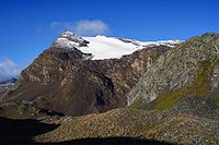
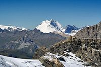
The Graian Alps are a mountain range in the western part of the Alps
. They are located in France
(Savoie
), Italy
(Piedmont
and the Aosta Valley), and Switzerland (western Valais
). The Col des Montets
separates them from the Chablais Alps
; the Col Ferret
and the Dora Baltea
valley separate them from the Pennine Alps
; the Col du Mont Cenis
separates them from the Cottian Alps
; the Arc
valley separates them from the Dauphiné Alps
.
The Graian Alps can be divided into four groups:
The western group contains the Vanoise National Park
; the eastern group contains the Gran Paradiso
national park.
The French side of the Graian Alps is drained by the river Isère
(Tarentaise
valley) and its tributary Arc
(Maurienne
valley), and by the Arve
. The Italian side is drained by the rivers Dora Baltea
, Orco
and Stura di Lanzo
, tributaries of the Po
.

Alps
The Alps is one of the great mountain range systems of Europe, stretching from Austria and Slovenia in the east through Italy, Switzerland, Liechtenstein and Germany to France in the west....
. They are located in France
France
The French Republic , The French Republic , The French Republic , (commonly known as France , is a unitary semi-presidential republic in Western Europe with several overseas territories and islands located on other continents and in the Indian, Pacific, and Atlantic oceans. Metropolitan France...
(Savoie
Savoie
Savoie is a French department located in the Rhône-Alpes region in the French Alps.Together with the Haute-Savoie, Savoie is one of the two departments of the historic region of Savoy that was annexed by France on June 14, 1860, following the signature of the Treaty of Turin on March 24, 1860...
), Italy
Italy
Italy , officially the Italian Republic languages]] under the European Charter for Regional or Minority Languages. In each of these, Italy's official name is as follows:;;;;;;;;), is a unitary parliamentary republic in South-Central Europe. To the north it borders France, Switzerland, Austria and...
(Piedmont
Piedmont
Piedmont is one of the 20 regions of Italy. It has an area of 25,402 square kilometres and a population of about 4.4 million. The capital of Piedmont is Turin. The main local language is Piedmontese. Occitan is also spoken by a minority in the Occitan Valleys situated in the Provinces of...
and the Aosta Valley), and Switzerland (western Valais
Valais
The Valais is one of the 26 cantons of Switzerland in the southwestern part of the country, around the valley of the Rhône from its headwaters to Lake Geneva, separating the Pennine Alps from the Bernese Alps. The canton is one of the drier parts of Switzerland in its central Rhône valley...
). The Col des Montets
Col des Montets
Col des Montets is a mountain pass in the French Alps in the Haute-Savoie department of France. It is on the road between Chamonix and Martigny in the canton of Valais, Switzerland.It lies between the Swiss Col de la Forclaz and Chamonix....
separates them from the Chablais Alps
Chablais Alps
The Chablais Alps are a mountain range in the western Alps. They are situated between Lake Geneva and the Mont Blanc Massif. The Col des Montets separates them from the Mont Blanc Massif in the south, and the Rhône valley separates them from the Bernese Alps in the east.The Chablais Alps are...
; the Col Ferret
Col Ferret
The Col Ferret is an Alpine pass between the canton of Valais and the Aosta Valley. This pass separates the Mont Blanc Massif from the Pennine Alps.-See also:* List of highest paved roads in Europe...
and the Dora Baltea
Dora Baltea
Dora Baltea or Doire Baltée , is a river in northern Italy. It is a left-hand tributary of the Po River, and is about 160 km long...
valley separate them from the Pennine Alps
Pennine Alps
The Pennine Alps are a mountain range in the western part of the Alps. They are located in Switzerland and Italy...
; the Col du Mont Cenis
Mont Cenis
Mont Cenis is a massif and pass in Savoie in France which forms the limit between the Cottian and Graian Alps.A road over the pass was built between 1803 and 1810 by Napoleon...
separates them from the Cottian Alps
Cottian Alps
The Cottian Alps are a mountain range in the southwestern part of the Alps. They form the border between France and Italy...
; the Arc
Arc (Savoie)
The Arc is a 128 km long river in the Savoie département of south-eastern France. It is a left tributary of the Isère River, which it joins at Chamousset, approximately 15 km downstream from Albertville. Its source is near the border with Italy, in the Graian Alps, northeast of Bonneval-sur-Arc...
valley separates them from the Dauphiné Alps
Dauphiné Alps
The Dauphiné Alps are a group of mountain ranges in southeastern France, west of the main chain of the Alps. They are separated from the Cottian Alps in the east by the Col du Galibier and the upper Durance valley; from the western Graian Alps in the north-east by the river Arc; from the lower...
.
The Graian Alps can be divided into four groups:
- the Mont Blanc group (north of the Little St Bernard Pass)
- the Central group (the watershed between the Little St Bernard Pass and the Col du Mont Cenis)
- the Western or French group,
- and the Eastern or Italian group.
The western group contains the Vanoise National Park
Vanoise National Park
Vanoise National Park , is a French national park in the Tarentaise Valley in the French Alps, created in 1963 after mobilization from the environmentalist movement against a touristic project. It was the first French national park. This park is in the département of Savoie...
; the eastern group contains the Gran Paradiso
Gran Paradiso
The Gran Paradiso is a mountain group between the Aosta Valley and Piedmont regions of north-west Italy. The peak, the 7th highest mountain in the Graian Alps with an elevation of 4,061 m, is close to Mont Blanc on the nearby border with France. On the French side of the border, the park is...
national park.
The French side of the Graian Alps is drained by the river Isère
Isère River
The Isère is a 286 km long river in southeastern France, in the Rhône-Alpes région. Its source is in the Alps on the border with Italy, near the ski resort Val d'Isère. It flows into the Rhône River in Pont-de-l'Isère, a few km north of Valence...
(Tarentaise
Tarentaise
Tarentaise can refer to the following:Places* Moûtiers, historically known as Tarentaise, in Savoy* Tarentaise Valley* Tarentaise, LoirePeople* Peter of TarentaiseOther*Tarentaise cattle...
valley) and its tributary Arc
Arc (Savoie)
The Arc is a 128 km long river in the Savoie département of south-eastern France. It is a left tributary of the Isère River, which it joins at Chamousset, approximately 15 km downstream from Albertville. Its source is near the border with Italy, in the Graian Alps, northeast of Bonneval-sur-Arc...
(Maurienne
Maurienne
Maurienne is one of the provinces of Savoy, corresponding to the arrondissement of Saint-Jean-de-Maurienne in France. It is also the original name of the capital of the province, now Saint-Jean-de-Maurienne.-Location:...
valley), and by the Arve
Arve
The Arve river flows for approximately 100 km through France, in the département of Haute-Savoie, and in Switzerland...
. The Italian side is drained by the rivers Dora Baltea
Dora Baltea
Dora Baltea or Doire Baltée , is a river in northern Italy. It is a left-hand tributary of the Po River, and is about 160 km long...
, Orco
Orco
The Orco is an Italian river. It originates in the glaciers of the Piedmontese slopes of Gran Paradiso, and after about 90 km reaches the Po River near Chivasso...
and Stura di Lanzo
Stura di Lanzo
Stura di Lanzo is a 65 km long river in north-western Italy . It is formed from several tributaries near Lanzo Torinese. It flows into the river Po in Turin.The name Stura has Celtic origin: stur, which means "to fall".-External links:...
, tributaries of the Po
Po River
The Po |Ligurian]]: Bodincus or Bodencus) is a river that flows either or – considering the length of the Maira, a right bank tributary – eastward across northern Italy, from a spring seeping from a stony hillside at Pian del Re, a flat place at the head of the Val Po under the northwest face...
.
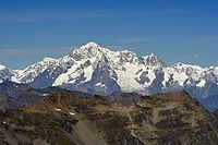
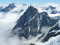
Mont Blanc group
| Name | metres | feet | Name | metres | feet | |
|---|---|---|---|---|---|---|
| Mont Blanc Mont Blanc Mont Blanc or Monte Bianco , meaning "White Mountain", is the highest mountain in the Alps, Western Europe and the European Union. It rises above sea level and is ranked 11th in the world in topographic prominence... |
4,810.45 | 15,782 | Aiguille du Tacul | 3,438 | 11,280 | |
| Mont Maudit Mont Maudit Mont Maudit is a mountain in the Mont Blanc massif in France and Italy. Until the end of the 18th century, Mont Blanc and its satellite peaks were collectively known in French as the Montagne Maudite.... |
4,471 | 14,669 | Pointe d'Orny | 3,274 | 10,742 | |
| Dôme du Goûter Dôme du Goûter The Dôme du Goûter is a mountain in the Mont Blanc massif. It is a shoulder of Mont Blanc, whose summit lies two kilometres to the south-east... |
4,331 | 14,210 | Dents du Midi Dents du Midi The Dents du Midi is a mountain chain situated in the Chablais Alps in the Canton of Valais, Switzerland. It is composed of seven distinct summits and reaches a height of 3257 metres... |
3,260 | 10,696 | |
| Grandes Jorasses Grandes Jorasses The Grandes Jorasses is a mountain in the Mont Blanc massif.The first ascent of the highest peak of the mountain was by Horace Walker with guides Melchior Anderegg, Johann Jaun and Julien Grange on 30 June 1868... |
4,205 | 13,797 | Mont Favre | 3,259 | 10,693 | |
| Aiguille Verte Aiguille Verte The Aiguille Verte is a mountain in the Mont Blanc massif in the French Alps.It was first climbed on 29 June 1865 by Edward Whymper, Christian Almer and Franz Biner, a fortnight before the fateful first ascent of the Matterhorn. Whymper was unable to climb with his usual guide, Michel Croz, who... |
4,127 | 13,541 | Tour Sallière | 3,227 | 10,588 | |
| Aiguille de Bionnassay Aiguille de Bionnassay The Aiguille de Bionnassay is a mountain in the Mont-Blanc massif of the Alps in France and Italy.... |
4,066 | 13,341 | Pointe de Léchaud | 3,127 | 10,260 | |
| Dent du Géant Dent du Géant The Dent du Géant is a mountain in the Mont Blanc massif in France and Italy.The mountain has two summits, eighty-eight feet apart and separated by a small col :*Pointe Graham , first ascent by W. W... |
4,013 | 13,166 | Mont Buet | 3,109 | 10,201 | |
| Trélatête | 3,911 | 12,832 | Mont Ruan | 3,078 | 10,099 | |
| Aiguille d'Argentière Aiguille d'Argentière The Aiguille d'Argentière is a mountain in the Mont Blanc massif on the border between France and Switzerland.The first ascent of the mountain was by a British party comprising Edward Whymper and A. Reilly with guides Michel Croz, M. Payot, H. Charlet on 15 July 1864... |
3,902 | 12,802 | Pic de Tenneverge | 2,982 | 9,784 | |
| Aiguille de Triolet Aiguille de Triolet The Aiguille de Triolet is a mountain in the Mont Blanc massif in France and Italy.-External links:*... |
3,876 | 12,717 | Aiguille du Belvédère (Aigs Rouges) | 2,966 | 9,731 | |
| Aiguille du Midi Aiguille du Midi The Aiguille du Midi is a mountain in the Mont Blanc massif in the French Alps.The cable car to the summit, the Téléphérique de l'Aiguille du Midi, was built in 1955 and held the title of the world's highest cable car for about two decades. It still holds the record as the highest vertical ascent... |
3,843 | 12,609 | Crammont | 2,737 | 8,980 | |
| Tour Noir Tour Noir The Tour Noir is a mountain in the Mont Blanc massif on the Swiss-French border.-External links:*... |
3,836 | 12,586 | Pointe des Fours | 2,719 | 8,921 | |
| Aiguille des Glaciers Aiguille des Glaciers The Aiguille des Glaciers is a mountain in the Mont Blanc massif in Savoie and Haute-Savoie, France and of Aosta Valley, Italy.... |
3,834 | 12,579 | Pointe du Colloney | 2,692 | 8,832 | |
| Mont Dolent Mont Dolent Mont Dolent is a mountain in the Mont Blanc massif that lies on the border of Italy and Switzerland.It is generally considered the tripoint between France, Italy and Switzerland, although the point itself lies at 3,749 metres, north-west of the summit of Mont Dolent.The first ascent of the... |
3,823 | 12,543 | Catogne | 2,599 | 8,527 | |
| Aiguille du Chardonnet Aiguille du Chardonnet The Aiguille du Chardonnet is a mountain in the Mont Blanc massif in Haute-Savoie, France.... |
3,822 | 12,540 | Mont Joly | 2,527 | 8,291 | |
| Aiguille du Dru Aiguille du Dru The Aiguille du Dru is a mountain in the Mont Blanc massif in the French Alps, lying to the east of the village of Les Praz in the Chamonix valley.The mountain has two summits:... |
3,754 | 12,316 | Brevent | 2,525 | 8,284 | |
| Dômes de Miage | 3,688 | 12,100 | Pointe de Sales | 2,494 | 8,183 | |
| Aiguille du Tour Aiguille du Tour The Aiguille du Tour is a mountain in the Mont Blanc massif on the Swiss-French border. The voie normale mountain is graded F and can be climbed from either the Albert Premier Hut on the French side or the Cabane d'Orny on the Swiss side.... |
3,540 | 11,615 | Aiguille de Varan | 2,488 | 8,163 | |
| Aiguille du Grépon Aiguille du Grépon The Aiguille du Grépon is a mountain in the Mont Blanc Massif in Haute-Savoie, France.... |
3,502 | 11,489 | Mont Chetif | 2,343 | 7,687 | |
| Aiguille des Charmoz | 3,442 | 11,293 |
Central group
| Name | metres | feet | Name | metres | feet | |
|---|---|---|---|---|---|---|
| Pointe de Charbonnel Pointe de Charbonnel Pointe de Charbonnel is a mountain of Savoie, France. It lies in the Graian Alps range. It has an altitude of 3752 metres above sea level.... |
3760 | 12,336 | Grande Aiguille Rousse | 3482 | 11,424 | |
| Aiguille de la Grande Sassière Aiguille de la Grande Sassière Aiguille de la Grande Sassière is a mountain in the Graian Alps, on the boundary between the Aosta Valley and the French department of Savoie.... |
3751 | 12,306 | Granta-Parey | 3473 | 11,395 | |
| Uia di Ciamarella Uia di Ciamarella Uia di Ciamarella or just Ciamarella is a mountain on the border between France and Italy.... |
3676 | 12,061 | Roc du Moulinet | 3469 | 11,382 | |
| Albaron | 3638 | 11,936 | Aiguille Pers | 3451 | 11,323 | |
| Pointe de Ronce Pointe de Ronce Pointe de Ronce is a mountain of Savoie, France. It lies in the Mont Cenis range. It has an altitude of 3612 metres above sea level.... |
3618 | 11,871 | Cima dell' Auille?? | 3446 | 11,306 | |
| Levanna | 3615 | 11,860 | Pointe de la Galise | 3345 | 10,975 | |
| Bec de l'Invergnan | 3608 | 11,838 | Pointe de la Traversière | 3341 | 10,962 | |
| Tsanteleina | 3606 | 11,831 | Ormelune/Pointe d'Archeboc | 3283 | 10,771 | |
| Bessanese | 3597 | 11,801 | Signal du Mont Iseran | 3241 | 10,634 | |
| Croce Rossa | 3567 | 11,703 | Grand Assaly | 3174 | 10,413 | |
| Punta d'Arnas | 3540 | 11,615 | Torre d'Ovarda | 3075 | 10,089 | |
| Rocciamelone | 3537 | 11,605 | Dôme de Val d'Isère | 3033 | 9951 | |
| Punta Chalanson | 3530 | 11,582 | Uia di Mondrone | 2964 | 9725 | |
| Grande Traversière | 3495 | 11,467 | Monte Unghiasse | 2939 | 9643 | |
| Testa del Rutor | 3486 | 11,438 | Monte Civrari | 2302 | 7553 |
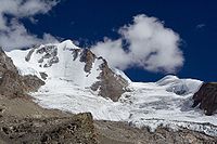
Eastern group
| Name | metres | feet | Name | metres | feet | |
|---|---|---|---|---|---|---|
| Gran Paradiso Gran Paradiso The Gran Paradiso is a mountain group between the Aosta Valley and Piedmont regions of north-west Italy. The peak, the 7th highest mountain in the Graian Alps with an elevation of 4,061 m, is close to Mont Blanc on the nearby border with France. On the French side of the border, the park is... |
4061 | 13,324 | Punta Tersiva | 3513 | 11,526 | |
| Grivola Grivola The Grivola is a mountain in the Graian Alps in Italy. It lies between the Valsavarenche and the Vallon di Cogne. Grivola means young lady in the Occitan language.-Huts:* Rifugio Federico Chabod * Bivacco Luciano Gratton... |
3969 | 13,022 | Punta Foura | 3410 | 11,188 | |
| Herbétet Herbétet Herbétet is a mountain in the Gran Paradiso massif, a sub-group of the Graian Alps, with an elevation of 3,778 m. It is located between the Val di Cogne and Valsevaranche.... |
3778 | 12,396 | Punta Sengie | 3408 | 11,182 | |
| Torre del Gran San Pietro Torre del Gran San Pietro Torre di San Gran Pietro is a mountain in the Gran Paradiso massif, a sub-group of the Graian Alps, with an elevation of 3,692 m. It is located at the boundary between Aosta Valley and Piedmont, near the Val di Cogne.... |
3692 | 12,113 | Punta Lavina | 3308 | 10,854 | |
| Ciarforon | 3665 | 12,025 | Rosa dei Banchi | 3164 | 10,381 | |
| Roccia Viva | 3650 | 11,976 | Becca di Nona | 3142 | 10,309 | |
| Becca di Gay | 3623 | 11,887 | Punta Pousset | 3046 | 9994 | |
| Mont Emilius | 3559 | 11,677 | Monte Marzo | 2750 | 9023 |
Western group
| Name | metres | feet | Name | metres | feet | |
|---|---|---|---|---|---|---|
| Grande Casse Grande Casse The Grande Casse is the highest mountain in the Vanoise Massif in the Graian Alps.The first ascent was by William Mathews with guides Michel Croz and E. Favre on 8 August 1860.-External links:*... |
3855 | 12,648 | Pointe de l'Échelle Pointe de l'Échelle The Pointe de l'Échelle is a mountain in the Vanoise Massif in Savoie, France.... |
3422 | 11,227 | |
| Mont Pourri Mont Pourri Mont Pourri is a mountain in the Vanoise Massif in the Graian Alps. It is located in the Vanoise National Park.-External links:* , Peakware World Mountain Encyclopedia.* , Peakbagger.*... |
3779 | 12,398 | Bellecôte Bellecôte The Bellecôte is a mountain in the Vanoise Massif in the Graian Alps, lying in the northern part of the Vanoise National Park and dominating the Peisey-Nancroix valley in Savoie. The north face is immense and austere, whereas the south face is more accessible.... |
3417 | 11,211 | |
| Dent Parrachée Dent Parrachée Dent Parrachée is a mountain of Savoie, France. It lies in the Massif de la Vanoise range. It has an altitude of 3697 metres above sea level.... |
3697 | 12,129 | Pointes de la Gliere | 3386 | 11,109 | |
| Grande Motte | 3653 | 11,985 | Pointe de Méan Martin | 3337 | 10,949 | |
| Dôme de l'Arpont | 3599 | 11,808 | Roche Chevrière | 3252 | 10,669 | |
| Dôme de Chasseforêt | 3586 | 11,765 | Pointe de la Réchasse | 3223 | 10,575 | |
| Aiguille de Péclet | 3566 | 11,700 | Petit Mont Blanc de Pralognan | 2685 | 8809 | |
| Aiguille de Polset | 3538 | 11,608 | Mont Jouvet | 2563 | 8409 | |
| Pointe de la Sana | 3436 | 11,273 | ||||
Passes
The main passes of the Graian Alps are shown in the table below. The group in which the pass is located is indicated with "MB" for Mont Blanc group, "C" for Central group, "E" for Eastern group, and "W" for Western group.| name | location | group | type | |elevation (m/ft) | |
|---|---|---|---|---|---|
| Col de la Brenva | Courmayeur Courmayeur Courmayeur is an Italian town and comune in the autonomous region of Aosta Valley, in northern Italy. It is located at the foot of Mont Blanc, the highest mountain in western Europe, in the Graian Alps range, and is crossed by the Dora Baltea... to Chamonix Chamonix Chamonix-Mont-Blanc or, more commonly, Chamonix is a commune in the Haute-Savoie département in the Rhône-Alpes region in south-eastern France. It was the site of the 1924 Winter Olympics, the first Winter Olympics... |
MB | snow | 4,333 | 14,217 |
| Col de Triolet | Chamonix to Courmayeur | MB | snow | 3,691 | 12,110 |
| Col d'Argentière | Chamonix to Orsières Orsières Orsières is a municipality in the district of Entremont in the canton of Valais in Switzerland.-Geography:Orsières has an area, , of . Of this area, 16.8% is used for agricultural purposes, while 25.2% is forested... |
MB | snow | 3,516 | 11,536 |
| Col de la Grande Rousse | Rhêmes Valley to Valgrisenche Valgrisenche Valgrisenche is a town and comune in the Aosta Valley region of north-western Italy.... |
C | snow | 3500 | 11,483 |
| Col de Talefre | Chamonix to Courmayeur | MB | snow | 3,484 | 11,430 |
| Col de Gebroulaz | Modane Modane Modane is a commune in the Savoie department in the Rhône-Alpes region in southeastern France.It was part of the Kingdom of Sardinia until 1860.-Transportation:... to Méribel Méribel Méribel is a ski resort in the Tarentaise Valley in the French Alps, situated near the town of Moutiers.Méribel refers to three neighbouring villages in the Les Allues commune of the Savoie département of France, near the town of Moûtiers , called Méribel Centre, Méribel-Mottaret and Méribel Village... |
W | snow | 3470 | 11,385 |
| Col de Monel | Cogne Cogne Cogne is a town and comune in Aosta Valley, northern Italy with 1469 inhabitants, as of 2005.Cogne is located in the valley with the same name, leading to the Gran Paradiso massif Ibex, wild goat, marmots, royal eagles are easy to see... to Locana Locana Locana is a comune in the Province of Turin in the Italian region Piedmont, located about 45 km northwest of Turin in the Orco Valley... |
E | snow | 3428 | 11,247 |
| Col de Miage | Les Contamines to Courmayeur | MB | snow | 3,376 | 11,077 |
| Col du Géant | Chamonix to Courmayeur | MB | snow | 3,371 | 11,060 |
| Col du Grand Paradis | Ceresole Reale Ceresole Reale Ceresole Reale is a comune in the Province of Turin in the Italian region Piedmont, located about 50 km northwest of Turin in the Orco Valley, on the border with France... to Valsavarenche Valsavarenche Valsavarenche is an Italian comune with a population of 186. It is located in the Aosta Valley, and is part of the Grand-Paradis Mountain Community.... |
E | snow | 3349 | 10,988 |
| Col du Charforon | Ceresole Reale to Valsavarenche | E | snow | 3331 | 10,929 |
| Col de Teleccio | Cogne to Locana | E | snow | 3326 | 10,913 |
| Col du Chardonnet | Chamonix to Orsières | MB | snow | 3,325 | 10,909 |
| Col de Lauzon | Cogne to the Valsavarenche | E | bridle path | 3301 | 10,831 |
| Col du Bouquetin | Bonneval-sur-Arc Bonneval-sur-Arc Bonneval-sur-Arc is a commune in the Savoie department in the Rhône-Alpes region in south-eastern France.-External links:*... to Val d'Isère Val d'Isère Val d'Isère is a commune of the Tarentaise Valley, in the Savoie department in south-eastern France. It lies from the border with Italy. It is on the border of the Vanoise National Park created in 1963. The Face de Bellevarde was the scene of the men's downhill race as part of the 1992 Winter... |
C | snow | 3300 | 10,827 |
| Col de St Grat | Valgrisenche to La Thuile La Thuile La Thuile is a town and comune in the Aosta Valley of northwest Italy.-Geography:La Thuile is situated in the Alps at the extreme north-west of the country, close to the French alpine town of La Rosière... |
C | snow | 3300 | 10,827 |
| Col du Tour | Chamonix to Orsières | MB | snow | 3,280 | 10,762 |
| Fenetre de Saleinaz | Saleinaz Glacier to Trient Glacier | MB | snow | 3,264 | 10,709 |
| Col de l'Herbetet | Cogne to Valsavarenche | E | snow | 3257 | 10,686 |
| Col du Collerin | Bessans Bessans Bessans is a commune in the Savoie department in the Rhône-Alpes region in south-eastern France.-Geography:Located on the Haute-Maurienne plateau, at an altitude of 1750 meters, the area is known for its sporting activities. Bessans is located in a valley, ideal for Nordic skiing... to Balme Balme Balme is a comune in the Province of Turin in the Italian region Piedmont, located about 45 km northwest of Turin, on the border with France. As of 31 December 2004, it had a population of 98 and an area of 63.1 km².... |
C | snow | 3202 | 10,506 |
| Col du Grand Etret | Ceresole Reale to Valsavaranche | E | snow | 3158 | 10,361 |
| Col de Bassac | Rhêmes Valley to Valgrisenche | C | snow | 3153 | 10,345 |
| Col du Carro | Bonneval-sur-Arc to Ceresole Reale | C | snow | 3140 | 10,302 |
| Col d'Arbole | Cogne to Brissogne Brissogne Brissogne is a town and comune in the Aosta Valley region of north-western Italy.... |
E | snow | 3137 | 10,292 |
| Col de la Goletta | Val d'Isère to the Rhêmes Valley | C | snow | 3120 | 10,237 |
| Col de Rhêmes | Val d'Isère to the Rhêmes Valley | C | snow | 3101 | 10,174 |
| Col de la Grande Casse | Pralognan to Termignon Termignon Termignon is a commune in the Savoie department in the Rhône-Alpes region in south-eastern France.... |
W | snow | 3100 | 10,171 |
| Col de Sea | Bonneval-sur-Arc to Forno Alpi Graie | C | snow | 3083 | 10,115 |
| Col de l'Autaret | Bessans to Usseglio Usseglio Usseglio is a comune in the Province of Turin in the Italian region Piedmont, located about 40 km northwest of Turin, on the border with France.... |
C | foot path | 3070 | 10,073 |
| Col de Girard | Bonneval-sur-Arc to Forno Alpi Graie | C | snow | 3044 | 9987 |
| Col Rosset | Valsavarenche to the Rhêmes Valley | C | bridle path | 3024 | 9922 |
| Col d'Arnas | Bessans to Balme | C | snow | 3014 | 9889 |
| Col de la Galise | Ceresole Reale to Val d'Isère | C | snow | 2998 | 9836 |
| Col de Sort | Valsavarenche to the Rhêmes Valley | E | bridle path | 2967 | 9735 |
| Quecees de Tignes | Val d'Isère to Termignon | W | snow | 2940 | 9646 |
| Col della Nouva | Cogne to Pont Canavese | E | bridle path | 2933 | 9623 |
| Col de Breuil | Bourg-Saint-Maurice Bourg-Saint-Maurice Bourg-Saint-Maurice, popularly known as Bourg, is a commune in the Savoie department in the Rhône-Alpes region in south-eastern France.It is the last large town along the Tarentaise valley in the heart of the French Alps.-History:... to La Thuile La Thuile La Thuile is a town and comune in the Aosta Valley of northwest Italy.-Geography:La Thuile is situated in the Alps at the extreme north-west of the country, close to the French alpine town of La Rosière... |
MB | snow | 2,879 | 9,446 |
| Col de Garin | Aosta Aosta Aosta is the principal city of the bilingual Aosta Valley in the Italian Alps, north-northwest of Turin. It is situated near the Italian entrance of the Mont Blanc Tunnel, at the confluence of the Buthier and the Dora Baltea, and at the junction of the Great and Little St. Bernard routes... to Cogne |
E | foot path | 2868 | 9411 |
| Collarin d'Arnas | Balme to Usseglio | C | snow | 2850 | 9351 |
| Colle della Finestra | Rhêmes Valley to the Valgrisenche | C | foot path | 2847 | 9341 |
| Fenetre de Champorcher | Cogne to Champorcher Champorcher Champorcher is a comune in the Aosta Valley region of north-western Italy, the main town in the Champorcher Valley.... |
E | bridle path | 2838 | 9311 |
| Col Vaudet | Sainte-Foy-Tarentaise Sainte-Foy-Tarentaise Sainte-Foy-Tarentaise is a commune in the Savoie department in the Rhône-Alpes region in south-eastern France.Sainte-Foy-Tarentaise is a village in the Tarentaise Valley in Savoie, France. The old village itself lies on the main road between Bourg-Saint-Maurice and Val-d'Isère... to the Valgrisenche |
C | foot path | 2836 | 9305 |
| Col de Bardoney | Cogne to Pont Canavese | E | snow | 2833 | 9295 |
| Col de Chaviere | Modane to Pralognan | W | foot path | 2806 | 9206 |
| Col de la Leisse | Tignes Tignes Tignes is a commune in the Tarentaise Valley, Savoie department in the Rhône-Alpes region in south-eastern France.It is also a ski resort near Val d'Isère, that are linked together as the "Espace Killy" region... to Termignon |
W | snow | 2780 | 9121 |
| Col de l'Iseran Col de l'Iseran Col de l'Iseran is the highest paved mountain pass in the Alps. A part of the Graian Alps, it is situated in the department of Savoie in France near the border with Italy. It is crossed by the D902.... |
Bonneval-sur-Arc to Val d'Isère | C | road | 2769 | 9085 |
| Ghicet di Sea | Balme to Forno Alpi Graie | C | foot path | 2735 | 8973 |
| Col de la Sachette | Tignes to Bourg-Saint-Maurice Bourg-Saint-Maurice Bourg-Saint-Maurice, popularly known as Bourg, is a commune in the Savoie department in the Rhône-Alpes region in south-eastern France.It is the last large town along the Tarentaise valley in the heart of the French Alps.-History:... |
W | foot path | 2729 | 8954 |
| Col du Palet | Tignes to Moûtiers or Bourg St Maurice | W | bridle path | 2658 | 8721 |
| Col du Mont | Ste Foy to the Valgrisenche | C | bridle path | 2646 | 8681 |
| Col du Nivolet | Ceresole Reale to the Valsavarenche | E | road | 2641 | 8665 |
| Colle della Crocetta | Ceresole Reale to Forno Alpi Graie | C | bridle path | 2636 | 8649 |
| Col de la Platiere | Saint-Jean-de-Maurienne Saint-Jean-de-Maurienne Saint-Jean-de-Maurienne is a commune in the Savoie department in the Rhône-Alpes region in south-eastern France. It is a sub-prefecture of the department.... to Moûtiers |
W | bridle path | 2600 | 8531 |
| Col du Mont Tondu | Les Contamines to Courmayeur | MB | snow | 2,590 | 8,498 |
| Col Ferret | Courmayeur to Orsières | MB | bridle path | 2,533 | 8,311 |
| Col de la Vanoise | Pralognan to Termignon | W | bridle path | 2527 | 8291 |
| Col de la Seigne | Les Chapieux to Courmayeur | MB | bridle path | 2,512 | 8,242 |
| Col de Susanfe | Champéry Champéry Champéry is a municipality in the district of Monthey in the canton of Valais in Switzerland.-History:Champéry is first mentioned in 1286 as Champery... to Salvan Salvan, Switzerland Salvan is a municipality in the district of Saint-Maurice, in the canton of Valais, Switzerland.-History:Salvan is first mentioned in 1018 as cum Silvano. Around 1025-31 it was mentioned as in monte Salvano. The municipality was formerly known by its German name Scharwang, however, that name is... |
MB | foot path | 2,500 | 8,202 |
| Col du Bonhomme | Contamines to Les Chapieux | MB | bridle path | 2,483 | 8,147 |
| Col de Sageroux | Sixt Sixt-Fer-à-Cheval Sixt-Fer-à-Cheval is a municipality in the Haute-Savoie department in the Rhône-Alpes region in southeastern France.- Geography :The town ranges in altitude from , and three-quarters of its area are part of a Natural Reserve and thus completely uninhabited... to Champéry |
MB | foot path | 2,413 | 7,917 |
| Col des Encombres | Saint-Michel-de-Maurienne Saint-Michel-de-Maurienne Saint-Michel-de-Maurienne is a commune in the Savoie department in the Rhône-Alpes region in south-eastern France.-See also:*Communes of the Savoie department*The 1917 Saint-Michel-de-Maurienne derailment, which killed several hundred French troops.... to Moûtiers |
W | bridle path | 2337 | 7668 |
| Col d'Anterne | Sixt to Servoz | MB | bridle path | 2,263 | 7,425 |
| Col de Balme | Chamonix to the Trient Valley | MB | bridle path | 2,201 | 7,221 |
| Little St Bernard Pass Little St Bernard Pass The Little St Bernard Pass is a mountain pass in the Alps on the France–Italy border. Its saddle is at 2188 metres above sea level. It is located between Savoie, France and Aosta Valley, Italy to the south of the Mont Blanc Massif, precisely on the main alpine watershed. There is also a Great St... |
Aosta to Moûtiers | C | road | 2188 | 7179 |
| Col de la Madeleine Col de la Madeleine Col de la Madeleine is a high mountain pass in the Alps in the department of Savoie in France.It connects La Chambre in Maurienne with Aigueblanche and Feissons-sur-Isère in Tarentaise. The southern approach from La Chambre is 19.3 km with an average grade of 8 percent. The northern approach... |
La Chambre La Chambre La Chambre is a commune in the Savoie department in the Rhône-Alpes region in south-eastern France.-References:*... to Moûtiers |
W | road | 1984 | 6509 |
| Colle Checrouit | Courmayeur to the Lac de Combal | MB | bridle path | 1,960 | 6,431 |
| Col de Voza | Chamonix to Les Contamines | MB | bridle path | 1,675 | 5,496 |
| Col de la Forclaz (F) | Chamonix to Saint-Gervais | MB | bridle path | 1,556 | 5,105 |
| Col de la Forclaz Col de la Forclaz Col de la Forclaz is a mountain pass in the Alps in the Canton of Valais in Switzerland. It connects Martigny at and Le Châtelard . The road from Martigny to the Col has an average gradient of 6% but in parts is more like 8%... (CH) |
Argentière Argentière Argentière is a picturesque skiing, alpine walking and mountaineering village in the French Alps, part of the commune of Chamonix Mont Blanc. Altitude: 1252m .-Geography:... to Martigny Martigny, Switzerland Martigny is the capital of the French-speaking district of Martigny in the canton of Valais in Switzerland. It lies at an elevation of , and its population is approximately 15000 inhabitants . It is a junction of roads joining Italy, France and Switzerland... |
MB | road | 1,520 | 4,987 |
External links
- Ascents in Gran Paradiso group - Czech and English
- Graian Alps on Summitpost - English