
Penner River
Encyclopedia
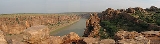
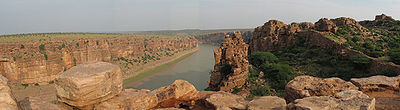
The Penner is a river of southern India
. The Penner rises on the hill of Nandi Hills
in Chikballapur District of Karnataka
state, and runs north and east through the state of Andhra Pradesh
to empty into the Bay of Bengal
. It is 597 kilometres (371 mi) long, with a drainage basin
55213 square kilometres (21,317.9 sq mi) large.
of the Penner and its tributaries covers part of the southern Deccan plateau, including most of the Rayalaseema
region of Andhra Pradesh
and part of Karnataka
. The Kolar Plateau
forms the divide between the Penner watershed and those of the Kaveri
, Ponnaiyar
, and Palar
rivers to the south. The Penner drains the northern portion of the plateau, which includes parts of Kolar
and Tumkur
districts in Karnataka. The Krishna River
and its tributaries drain the Deccan plateau to the west and north of the Penner's watershed, and the low Erramala
hills forms the northern divide of the Penner basin. The upper watershed of the Penner includes Cuddapah District, central and eastern Anantapur District
, the southern part of Kurnool District
, northwestern Chittoor District
. The main tributaries of the Penner are the Jayamangali, Kunderu and Sagileru from the north, and the Chitravati, Papaghni and Cheyyeru from the south. The Penner then flows east through a gap in the Eastern Ghats
ranges onto the plain of Coastal Andhra
, where it empties into the Bay of Bengal 15 km east of Nellore
at a place called Utukuru(also Vutukuru).
Estuary
The estuary
of the Penner river extends 7 km upstream from the Bay of Bengal. Tidal influence and salt water extends further upstream during the November to June dry season. Coastal dunes as high as 7 meters form around the river mouth. Upputeru tidal creek, 15 km in length, and Isakapalli lagoon, separated from the Bay of Bengal by the Isakapalli barrier island, 180 m long and up to 3 m high, form the main coastal wetland
s.
The upper basin of the Penner is largely made up of ancient Archean
rocks, principally granite
and schist
. The lower basin is made up of young sediments, including laterite
and recent alluvium
.
climate. The upper basin of the Penner is semi-arid, with summer temperatures of 25–46 °C and winter temperatures of 18–28°C. Most of the rainfall is provided by the moisture-bearing southwest monsoon, which provides rain to most of India between June and September. The Penner basin lies in the rain shadow
of the high Western Ghats
ranges, which prevents much moisture from reaching the region. Post-monsoon cyclonic storms in the coastal region produce additional rain during September and October. The winter northeast monsoon, which provides rain between December and March, provides little rain to the upper basin and slightly more to the lower basin. It varies greatly from year to year in south India, sometimes bringing powerful cyclonic storms with flooding and high winds. The mean annual rainfall is 550 mm/year in Anantapur, and 900 mm/year in Nellore. The Penner basin suffered from a prolonged drought in the 1990s, which caused much misery among the regions farmers and generated political demands to build an aqueduct
to bring water from the Krishna River to Rayalaseema.
, thorn forest, and xeric shrublands
. Most of the dry tropical forest has now disappeared, due to clearance for grazing and overharvesting the forests for timber and firewood, replaced by thorny shrublands. The remnant forests of the Deccan are largely deciduous
, dropping their leaves in the dry winter and spring months. The East Deccan dry evergreen forests
of Coastal Andhra were evergreen, but these forests have largely been reduced to tiny remnant pockets.
lies on Upputeru creek, and was planned to be developed into a deep-water port by 2006. Buckingham Canal
, a navigable man-made waterway that runs just behind the coast, allows small boats from the Penner to get to Chennai
in the south and the Krishna River
delta to the north.
India
India , officially the Republic of India , is a country in South Asia. It is the seventh-largest country by geographical area, the second-most populous country with over 1.2 billion people, and the most populous democracy in the world...
. The Penner rises on the hill of Nandi Hills
Nandi Hills, India
Nandi Hills or Nandidurg is an ancient hill fortress of southern India, in the Chikkaballapur district of Karnataka state. It is located just 10 km from Chickballapur town and approximately 60 km from the city of Bangalore...
in Chikballapur District of Karnataka
Karnataka
Karnataka , the land of the Kannadigas, is a state in South West India. It was created on 1 November 1956, with the passing of the States Reorganisation Act and this day is annually celebrated as Karnataka Rajyotsava...
state, and runs north and east through the state of Andhra Pradesh
Andhra Pradesh
Andhra Pradesh , is one of the 28 states of India, situated on the southeastern coast of India. It is India's fourth largest state by area and fifth largest by population. Its capital and largest city by population is Hyderabad.The total GDP of Andhra Pradesh is $100 billion and is ranked third...
to empty into the Bay of Bengal
Bay of Bengal
The Bay of Bengal , the largest bay in the world, forms the northeastern part of the Indian Ocean. It resembles a triangle in shape, and is bordered mostly by the Eastern Coast of India, southern coast of Bangladesh and Sri Lanka to the west and Burma and the Andaman and Nicobar Islands to the...
. It is 597 kilometres (371 mi) long, with a drainage basin
Drainage basin
A drainage basin is an extent or an area of land where surface water from rain and melting snow or ice converges to a single point, usually the exit of the basin, where the waters join another waterbody, such as a river, lake, reservoir, estuary, wetland, sea, or ocean...
55213 square kilometres (21,317.9 sq mi) large.
Geography
The watershedDrainage basin
A drainage basin is an extent or an area of land where surface water from rain and melting snow or ice converges to a single point, usually the exit of the basin, where the waters join another waterbody, such as a river, lake, reservoir, estuary, wetland, sea, or ocean...
of the Penner and its tributaries covers part of the southern Deccan plateau, including most of the Rayalaseema
Rayalaseema
Rayalaseema is a geographic region in the state of Andhra Pradesh in India. It includes the districts of Anantapur, Chittoor, Kadapa, Kurnool. These Telugu speaking districts were part of Madras Presidency until 1953 when Telugu speaking districts of Madras presidency were carved out to form...
region of Andhra Pradesh
Andhra Pradesh
Andhra Pradesh , is one of the 28 states of India, situated on the southeastern coast of India. It is India's fourth largest state by area and fifth largest by population. Its capital and largest city by population is Hyderabad.The total GDP of Andhra Pradesh is $100 billion and is ranked third...
and part of Karnataka
Karnataka
Karnataka , the land of the Kannadigas, is a state in South West India. It was created on 1 November 1956, with the passing of the States Reorganisation Act and this day is annually celebrated as Karnataka Rajyotsava...
. The Kolar Plateau
Kolar Plateau
Kolar Plateau lies to the south Karnataka ,formerly Mysore state, in Southern India. The famous Kolar gold fields are part of the region.It is, basically, a dry zone, with abundant scrub vegetation suitable only for Sheep husbandry.It is also famour for silk and milk as many farmers depending on...
forms the divide between the Penner watershed and those of the Kaveri
Kaveri River
The Kaveri , also spelled Cauvery in English, is a large Indian river. The origin of the river is traditionally placed at Talakaveri, Kodagu in the Western Ghats in Karnataka, flows generally south and east through Karnataka and Tamil Nadu and across the southern Deccan plateau through the...
, Ponnaiyar
Ponnaiyar River
The Ponnaiyar is a river in southern India. It rises on the hill of Nandidrug in Kolar District of Karnataka state, and flows south and then east for through Karnataka and Tamil Nadu, emptying into the Bay of Bengal at Cuddalore....
, and Palar
Palar River
Palar is a river of southern India. It rises in Nandi Hills, India in Kolar district of Karnataka state, and flows 93 km in Karnataka, 33 km in Andhra Pradesh and 222 km in Tamil Nadu before its confluence into the Bay of Bengal at Vayalur about 100 km south of Chennai...
rivers to the south. The Penner drains the northern portion of the plateau, which includes parts of Kolar
Kolar
Kolara is a city in the South Indian state of Karnataka. It is the headquarters of Kolar District. It is known for being one of the gold mining sites in India....
and Tumkur
Tumkur
Tumkur is one of the busiest industrial towns located in the state of Karnataka. Since 28 August 2010, Tumkur has been accorded the status of a Corporation city. It is situated at a distance of 70 kilometers north west of the city of Bangalore along National Highway 4...
districts in Karnataka. The Krishna River
Krishna River
The Krishna River , is one of the longest rivers in central-southern India, about . It is also referred to as Krishnaveni in its original nomenclature...
and its tributaries drain the Deccan plateau to the west and north of the Penner's watershed, and the low Erramala
Erramala
The Erramala are a range of low hills in southern India, in Kurnool district of Andhra Pradesh state. The Erramala hills lie on the Deccan plateau, running east-west and dividing the basin of the Penner River to the south from the basin of the Krishna River to the north.In the east lies the higher...
hills forms the northern divide of the Penner basin. The upper watershed of the Penner includes Cuddapah District, central and eastern Anantapur District
Anantapur district
Anantapur District , ) is one of the 23 districts in Andhra Pradesh, India. The district headquarters is Anantapur City. It is currently a part of the Red Corridor.- Geography :...
, the southern part of Kurnool District
Kurnool district
Kurnool District is a district in the state of Andhra Pradesh, India, located in the west-central part of the state on the southern banks of the Tungabhadra and Handri rivers. The town of Kurnool is currently the headquarters of the district...
, northwestern Chittoor District
Chittoor district
Chittoor District , also known as Chittur, is a district of India's Andhra Pradesh state. The district headquarters is Chittoor City. The district has a population of 4,170,468 according to 2011 census of India. Chittoor district is famous for the Tirupati, Kanipakam and Sri Kalahasti temples...
. The main tributaries of the Penner are the Jayamangali, Kunderu and Sagileru from the north, and the Chitravati, Papaghni and Cheyyeru from the south. The Penner then flows east through a gap in the Eastern Ghats
Eastern Ghats
The Eastern Ghats or Eastern Ghauts are a discontinuous range of mountains along India's eastern coast. The Eastern Ghats run from West Bengal state in the north, through Orissa and Andhra Pradesh to Tamil Nadu in the south passing some parts of Karnataka. They are eroded and cut through by the...
ranges onto the plain of Coastal Andhra
Coastal Andhra
Coastal Andhra or Kosta, is a region of India's Andhra Pradesh State. This region was part of Madras State before 1953 and Andhra State from 1953 to 1956. According to the 2011 census, it has an area of and a population of 3,41,93,868...
, where it empties into the Bay of Bengal 15 km east of Nellore
Nellore
Nellore , is a city and headquarters of Potti Sri Ramulu Nellore District, formerly Nellore district.And in the state of Andhra Pradesh. Ancient name of Nellore was "Vikrama Simhapuri"....
at a place called Utukuru(also Vutukuru).
Estuary
The estuary
Estuary
An estuary is a partly enclosed coastal body of water with one or more rivers or streams flowing into it, and with a free connection to the open sea....
of the Penner river extends 7 km upstream from the Bay of Bengal. Tidal influence and salt water extends further upstream during the November to June dry season. Coastal dunes as high as 7 meters form around the river mouth. Upputeru tidal creek, 15 km in length, and Isakapalli lagoon, separated from the Bay of Bengal by the Isakapalli barrier island, 180 m long and up to 3 m high, form the main coastal wetland
Wetland
A wetland is an area of land whose soil is saturated with water either permanently or seasonally. Wetlands are categorised by their characteristic vegetation, which is adapted to these unique soil conditions....
s.
The upper basin of the Penner is largely made up of ancient Archean
Archean
The Archean , also spelled Archeozoic or Archæozoic) is a geologic eon before the Paleoproterozoic Era of the Proterozoic Eon, before 2.5 Ga ago. Instead of being based on stratigraphy, this date is defined chronometrically...
rocks, principally granite
Granite
Granite is a common and widely occurring type of intrusive, felsic, igneous rock. Granite usually has a medium- to coarse-grained texture. Occasionally some individual crystals are larger than the groundmass, in which case the texture is known as porphyritic. A granitic rock with a porphyritic...
and schist
Schist
The schists constitute a group of medium-grade metamorphic rocks, chiefly notable for the preponderance of lamellar minerals such as micas, chlorite, talc, hornblende, graphite, and others. Quartz often occurs in drawn-out grains to such an extent that a particular form called quartz schist is...
. The lower basin is made up of young sediments, including laterite
Laterite
Laterites are soil types rich in iron and aluminium, formed in hot and wet tropical areas. Nearly all laterites are rusty-red because of iron oxides. They develop by intensive and long-lasting weathering of the underlying parent rock...
and recent alluvium
Alluvium
Alluvium is loose, unconsolidated soil or sediments, eroded, deposited, and reshaped by water in some form in a non-marine setting. Alluvium is typically made up of a variety of materials, including fine particles of silt and clay and larger particles of sand and gravel...
.
Climate
The Penner basin has a dry tropical monsoonMonsoon
Monsoon is traditionally defined as a seasonal reversing wind accompanied by corresponding changes in precipitation, but is now used to describe seasonal changes in atmospheric circulation and precipitation associated with the asymmetric heating of land and sea...
climate. The upper basin of the Penner is semi-arid, with summer temperatures of 25–46 °C and winter temperatures of 18–28°C. Most of the rainfall is provided by the moisture-bearing southwest monsoon, which provides rain to most of India between June and September. The Penner basin lies in the rain shadow
Rain shadow
A rain shadow is a dry area on the lee side of a mountainous area. The mountains block the passage of rain-producing weather systems, casting a "shadow" of dryness behind them. As shown by the diagram to the right, the warm moist air is "pulled" by the prevailing winds over a mountain...
of the high Western Ghats
Western Ghats
The Western Ghats, Western Ghauts or the Sahyādri is a mountain range along the western side of India. It runs north to south along the western edge of the Deccan Plateau, and separates the plateau from a narrow coastal plain along the Arabian Sea. The Western Ghats block rainfall to the Deccan...
ranges, which prevents much moisture from reaching the region. Post-monsoon cyclonic storms in the coastal region produce additional rain during September and October. The winter northeast monsoon, which provides rain between December and March, provides little rain to the upper basin and slightly more to the lower basin. It varies greatly from year to year in south India, sometimes bringing powerful cyclonic storms with flooding and high winds. The mean annual rainfall is 550 mm/year in Anantapur, and 900 mm/year in Nellore. The Penner basin suffered from a prolonged drought in the 1990s, which caused much misery among the regions farmers and generated political demands to build an aqueduct
Aqueduct
An aqueduct is a water supply or navigable channel constructed to convey water. In modern engineering, the term is used for any system of pipes, ditches, canals, tunnels, and other structures used for this purpose....
to bring water from the Krishna River to Rayalaseema.
Vegetation
The upper basin was formerly covered by tropical dry forestTropical and subtropical dry broadleaf forests
The tropical and subtropical dry broadleaf forest biome, also known as tropical dry forest, is located at tropical and subtropical latitudes. Though these forests occur in climates that are warm year-round, and may receive several hundred centimeters of rain per year, they have long dry seasons...
, thorn forest, and xeric shrublands
Deserts and xeric shrublands
Deserts and xeric shrublands is a biome characterized by, relating to, or requiring only a small amount of moisture.-Definition and occurrence:...
. Most of the dry tropical forest has now disappeared, due to clearance for grazing and overharvesting the forests for timber and firewood, replaced by thorny shrublands. The remnant forests of the Deccan are largely deciduous
Deciduous
Deciduous means "falling off at maturity" or "tending to fall off", and is typically used in reference to trees or shrubs that lose their leaves seasonally, and to the shedding of other plant structures such as petals after flowering or fruit when ripe...
, dropping their leaves in the dry winter and spring months. The East Deccan dry evergreen forests
East Deccan dry evergreen forests
The East Deccan dry evergreen forests are an ecoregion of southeastern India. The ecoregion includes the coastal region behind the Coromandel Coast on the Bay of Bengal, between the Eastern Ghats and the sea...
of Coastal Andhra were evergreen, but these forests have largely been reduced to tiny remnant pockets.
Port
The small boat port of KrishnapatnamKrishnapatnam
Krishnapatnam or Kistnapatam is a port town in Muthukur mandal of Nellore district in Andhra Pradesh, India.-Description:Krishnapatnam is a major port and market center. It is situated at a distance of 24 km from Nellore City in Nellore District, the southernmost coastal district in the state...
lies on Upputeru creek, and was planned to be developed into a deep-water port by 2006. Buckingham Canal
Buckingham Canal
The Buckingham Canal is a long fresh water navigation canal, running parallel to the Coromandel Coast of South India from Vijayawada in Andhra Pradesh to Villupuram District in Tamil Nadu. The canal connects most of the natural backwaters along the coast to the port of Chennai...
, a navigable man-made waterway that runs just behind the coast, allows small boats from the Penner to get to Chennai
Chennai
Chennai , formerly known as Madras or Madarasapatinam , is the capital city of the Indian state of Tamil Nadu, located on the Coromandel Coast off the Bay of Bengal. Chennai is the fourth most populous metropolitan area and the sixth most populous city in India...
in the south and the Krishna River
Krishna River
The Krishna River , is one of the longest rivers in central-southern India, about . It is also referred to as Krishnaveni in its original nomenclature...
delta to the north.