

Bulkeley
Encyclopedia
Bulkeley is a village and civil parish in the unitary authority of Cheshire East
and the ceremonial county of Cheshire
, England
. The village is situated at on the A534 about 9 miles west of Nantwich
. The civil parish also includes the small settlement of Bulkelehay (also Bulkeleyhay or Bulkeley Hey) at , with a total population just below 250. Bulkeley Hill falls within the civil parish. The name is first recorded as Bulceleia in 1086 and is from Old English bulluc + leah 'pasture where bullocks graze.'
Borough Council, which was succeeded on 1 April 2009 by the new unitary authority
of Cheshire East
. Bulkeley falls in the parliamentary constituency of Eddisbury
, which has been represented by Stephen O'Brien since a by-election in 1999.
. It is owned by the National Trust
, and its wooded slopes include 12 acres (5 hectares) of semi-natural ancient woodland. The hill has been designated a county site of biological importance for its woodland and grassland habitats. A wider area covering the northern part of the civil parish has also been designated an Area of Special County Value. Another unnamed elevation of around 135 metres is located south west of Bulkeley village at , and an unnamed brook runs east–west along the valley between it and Bulkeley Hill.
Two covered reservoirs are located on Bulkeley Hill (at and ), with a pumping station at the base ; a disused inclined plane runs westwards from the pumping station. Formerly owned by Staffordshire Potteries Water Board, the facility is now operated by Severn Trent Water
. A small wooded area of access land containing two ponds is located at , immediately east of Bulkeley village and north of the A534, and there are several other meres and ponds scattered across the farmland.
The land use is predominantly agricultural, with cattle pasture, horse paddocks and some arable land
.
is a three-storey mansion in brown brick which dates from the mid-18th century; it is grade II* listed. Springfield Cottage is a timber-framed cottage dating from the late 17th century. A former corn mill stands on Mill Lane to the north of Bulkeley village.
Bulkeley Grange
is a grade-II-listed Victorian red-brick mansion in Jacobean style; the house was rebuilt by railway builder, Thomas Brassey
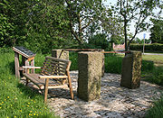
, in 1843. A monument consisting of four inscribed sandstone pillars connected by iron straps was erected around an oak tree near The Grange in 1845, to commemorate Brassey's fortieth birthday. In 2007, it was moved to a location just to the east of Bulkeley village, adjacent to the A534 ; the site has an interpretative sign.
runs east–west across the civil parish. Other through routes include Stone House Lane, which runs from the A534 to Peckforton
. Mill Lane connects Stone House Lane with the A534 and Cholmondeley Lane runs south to Bulkelehay. The Sandstone Trail
long-distance footpath runs over Bulkeley Hill.
and Bishop Heber High School
in Malpas
.
Cheshire East
Cheshire East is a unitary authority area with borough status in the ceremonial county of Cheshire, England.The borough was established in April 2009 as part of the 2009 structural changes to local government in England, by virtue of an order under the Local Government and Public Involvement in...
and the ceremonial county of Cheshire
Cheshire
Cheshire is a ceremonial county in North West England. Cheshire's county town is the city of Chester, although its largest town is Warrington. Other major towns include Widnes, Congleton, Crewe, Ellesmere Port, Runcorn, Macclesfield, Winsford, Northwich, and Wilmslow...
, England
England
England is a country that is part of the United Kingdom. It shares land borders with Scotland to the north and Wales to the west; the Irish Sea is to the north west, the Celtic Sea to the south west, with the North Sea to the east and the English Channel to the south separating it from continental...
. The village is situated at on the A534 about 9 miles west of Nantwich
Nantwich
Nantwich is a market town and civil parish in the Borough of Cheshire East and the ceremonial county of Cheshire, England. The town gives its name to the parliamentary constituency of Crewe and Nantwich...
. The civil parish also includes the small settlement of Bulkelehay (also Bulkeleyhay or Bulkeley Hey) at , with a total population just below 250. Bulkeley Hill falls within the civil parish. The name is first recorded as Bulceleia in 1086 and is from Old English bulluc + leah 'pasture where bullocks graze.'
Governance
Bulkeley is administered jointly with Ridley by the Bulkeley & Ridley Parish Council. From 1974 the civil parish was served by Crewe and NantwichCrewe and Nantwich
Crewe and Nantwich was, from 1974 to 2009, a local government district with borough status in Cheshire, England. It had a population of 111,007...
Borough Council, which was succeeded on 1 April 2009 by the new unitary authority
Unitary authority
A unitary authority is a type of local authority that has a single tier and is responsible for all local government functions within its area or performs additional functions which elsewhere in the relevant country are usually performed by national government or a higher level of sub-national...
of Cheshire East
Cheshire East
Cheshire East is a unitary authority area with borough status in the ceremonial county of Cheshire, England.The borough was established in April 2009 as part of the 2009 structural changes to local government in England, by virtue of an order under the Local Government and Public Involvement in...
. Bulkeley falls in the parliamentary constituency of Eddisbury
Eddisbury (UK Parliament constituency)
Eddisbury is a county constituency represented in the House of Commons of the Parliament of the United Kingdom. It elects one Member of Parliament by the first-past-the-post system of election.- Boundaries :...
, which has been represented by Stephen O'Brien since a by-election in 1999.
Geography and economy
Bulkeley Hill forms the southern end of the Peckforton HillsPeckforton Hills
The Peckforton Hills are a sandstone ridge running broadly northeast–southwest in the west of the English county of Cheshire. They form a significant part of the longer Mid Cheshire Ridge which extends southwards from Frodsham towards Malpas....
. It is owned by the National Trust
National Trust for Places of Historic Interest or Natural Beauty
The National Trust for Places of Historic Interest or Natural Beauty, usually known as the National Trust, is a conservation organisation in England, Wales and Northern Ireland...
, and its wooded slopes include 12 acres (5 hectares) of semi-natural ancient woodland. The hill has been designated a county site of biological importance for its woodland and grassland habitats. A wider area covering the northern part of the civil parish has also been designated an Area of Special County Value. Another unnamed elevation of around 135 metres is located south west of Bulkeley village at , and an unnamed brook runs east–west along the valley between it and Bulkeley Hill.
Two covered reservoirs are located on Bulkeley Hill (at and ), with a pumping station at the base ; a disused inclined plane runs westwards from the pumping station. Formerly owned by Staffordshire Potteries Water Board, the facility is now operated by Severn Trent Water
Severn Trent
Severn Trent plc is a British public utility. It is traded on the London Stock Exchange and is a constituent of the FTSE 100 Index.Severn Trent is a group of companies employing more than 15,000 people across the UK, US and mainland Europe, with some involvement in the Middle East.The main...
. A small wooded area of access land containing two ponds is located at , immediately east of Bulkeley village and north of the A534, and there are several other meres and ponds scattered across the farmland.
The land use is predominantly agricultural, with cattle pasture, horse paddocks and some arable land
Arable land
In geography and agriculture, arable land is land that can be used for growing crops. It includes all land under temporary crops , temporary meadows for mowing or pasture, land under market and kitchen gardens and land temporarily fallow...
.
Demography
According to the 2001 census the civil parish had a population of 240 in 106 households. This represents an increase from the 1951 population; the historical population figures were 184 (1801), 197 (1851), 168 (1901) and 146 (1951).Places of worship
Bulkeley Methodist Church is a red-brick chapel in Bulkeley village. Dating from 1861, it was formerly the Jubilee Primitive Methodist Chapel and is listed at grade II.Other landmarks
Bulkeley HallBulkeley Hall
Bulkeley Hall is a country house to the southwest of the village of Bulkeley, Cheshire, England. It dates from the middle of the 18th century, and was built for Thomas Bulkeley. The house is constructed in brick with a slate roof. Its architectural style is Georgian. The entrance front...
is a three-storey mansion in brown brick which dates from the mid-18th century; it is grade II* listed. Springfield Cottage is a timber-framed cottage dating from the late 17th century. A former corn mill stands on Mill Lane to the north of Bulkeley village.
Bulkeley Grange
Bulkeley Grange
Bulkeley Grange is a country house to the southeast of the village of Bulkeley, Cheshire, England. It replaced an earlier timber-framed house on the site, Bulkeley Old Hall, built by Thomas Brassey in about 1600. Bulkeley Grange was built in 1867 by his successor and namesake, the railway...
is a grade-II-listed Victorian red-brick mansion in Jacobean style; the house was rebuilt by railway builder, Thomas Brassey
Thomas Brassey
Thomas Brassey was an English civil engineering contractor and manufacturer of building materials who was responsible for building much of the world's railways in the 19th century. By 1847, he had built about one-third of the railways in Britain, and by time of his death in 1870 he had built one...
, in 1843. A monument consisting of four inscribed sandstone pillars connected by iron straps was erected around an oak tree near The Grange in 1845, to commemorate Brassey's fortieth birthday. In 2007, it was moved to a location just to the east of Bulkeley village, adjacent to the A534 ; the site has an interpretative sign.
Transport
The A534 (Wrexham Road) between Nantwich and WrexhamWrexham
Wrexham is a town in Wales. It is the administrative centre of the wider Wrexham County Borough, and the largest town in North Wales, located in the east of the region. It is situated between the Welsh mountains and the lower Dee Valley close to the border with Cheshire, England...
runs east–west across the civil parish. Other through routes include Stone House Lane, which runs from the A534 to Peckforton
Peckforton
Peckforton is a scattered settlement and civil parish in the unitary authority of Cheshire East and the ceremonial county of Cheshire, England. The settlement is located to the north east of Malpas and miles to the west of Nantwich. The total population of the civil parish is somewhat over 100...
. Mill Lane connects Stone House Lane with the A534 and Cholmondeley Lane runs south to Bulkelehay. The Sandstone Trail
Sandstone Trail
The Sandstone Trail is a long-distance walkers' path, following sandstone ridges running north–south from Frodsham in central Cheshire to Whitchurch just over the Shropshire border. The path was created in 1974 and extended in the 1990s...
long-distance footpath runs over Bulkeley Hill.
Education
Bulkeley civil parish falls within the catchment areas of Bickerton Holy Trinity CE Primary School in BickertonBickerton, Cheshire
Bickerton is a village and civil parish in the unitary authority of Cheshire East and the ceremonial county of Cheshire, England, about eight miles north of Whitchurch in Shropshire. The parish also includes the small settlement of Gallantry Bank, with a total population of over 200...
and Bishop Heber High School
Bishop Heber High School
Bishop Heber High School is a comprehensive secondary school and specialist languages college in Malpas, Cheshire. The school itself is named after Reginald Heber who was an English bishop born in Malpas, Cheshire and is now remembered chiefly as a hymn-writer.-Notable alumni:*Ben Foden, Rugby...
in Malpas
Malpas, Cheshire
Malpas is a large village which used to be a market town, and it is also a civil parish in the unitary authority of Cheshire West and Chester and the ceremonial county of Cheshire, England. The parish lies on the border with Shropshire and Wales...
.