

River Weaver
Encyclopedia
The River Weaver is a river, navigable in its lower reaches, running in a curving route anti-clockwise across west Cheshire
, northern England
. Improvements to the river to make it navigable were authorised in 1720 and the work, which included eleven locks, was completed in 1732. An unusual clause in the enabling Act of Parliament stipulated that profits should be given to the County of Cheshire for the improvement of roads and bridges, but the navigation was not initially profitable, and it was 1775 before the first payments were made. Trade continued to rise, and by 1845, over £500,000 had been given to the county.
The major trade was salt. The arrival of the Trent and Mersey Canal
at Anderton in 1773 was detrimental to the salt trade at first, but ultimately beneficial, as salt was tipped down chutes from the canal into barges on the navigation. Access to the river was improved in 1810 by the Weston Canal, which provided a link to Weston Point, where boats could reach the River Mersey at most states of the tide, as the water was deeper. The navigation was completely reconstructed between 1870 and 1900, with the original locks being replaced by five much larger locks, capable of handling 1000-tonne coasters. With the opening of the Manchester Ship Canal
, a new lock was constructed at Weston Marsh, which gave direct access to the ship canal without having to pass through the docks at Weston Point. All water from the river entered the canal nearby, and any surplus was released into the River Mersey
through the Weaver sluices, which were located just upstream of the junction.
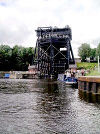
A notable feature is the Anderton Boat Lift
, which is near Northwich, and links the Weaver with the Trent and Mersey Canal some 50 feet (15 m) above. It was opened in 1875, to allow canal boats to reach the Weaver, and although closed on safety grounds in 1983, it was refurbished and reopened in 2002. Many of the structures of the navigation are of historical importance, and are grade II listed. They include the Hayhurst swing bridge and Northwich Town bridge, which are believed to be the earliest swing bridges powered by electricity. Both have a sectional pontoon, which is immersed in the river and carries about 80 per cent of the weight of the bridge. Dutton Horse bridge, which carries the towpath over the weir stream at Dutton, is one of the earliest surviving laminated timber structures. Dutton railway viaduct, which was built by Joseph Locke
and George Stephenson
for the Grand Junction Railway, is grade II* listed, and a civic celebration was held on its completion, as there had been no deaths and no serious injuries to the workers during its construction.
, it initially flows in a south-easterly direction towards the border with Shropshire
, fed by tributaries some of which rise in north Shropshire. The first of three canal crossings occurs just before the village of Wrenbury
, when the Llangollen Canal
crosses its course. After flowing through the village, it passes to the west of the Cheshire village of Audlem
, where it starts to flow approximately northwards across the Cheshire Plain. Shortly afterwards, the Shropshire Union Canal
is carried over it on Moss Hall aqueduct. The first significant town on the river is the market town of Nantwich
, where an early 19th century stone bridge, with a single span, crosses the river. Continuing northwards, it passes under the Middlewich Branch
of the Shropshire Union Canal before the village of Church Minshull. The aqueduct carrying the canal was designed by Thomas Telford
and was built of brick with stone bands between 1827 and 1833. The river flows through a central arch, and there are flood relief arches on each side of the channel. The two waterways run roughly parallel for several miles. They diverge near Winsford
, the current head of navigation, and at Northwich
the river turns to flow north-west across north Cheshire
.
Below Winsford, the course of the river has been altered several times, by the construction of cuts and locks, to enable small ships to trade on it. The river formerly joined the River Mersey
at Weston Marsh, but since the construction of the Manchester Ship Canal
, begun in 1887, it has flowed into the canal, from where surplus water enters the Mersey by the Weaver sluices, just upstream of the junction. The tidal river section below Frodsham
has been bypassed by the Weston Canal since 1810, and is no longer navigable, as Frodsham Lock is derelict.
to authorise improvements to the river was obtained by three gentlemen of Cheshire. The act was dated 23 March 1720 and authorised work between Frodsham bridge and Winsford bridge. Rates for tolls were set, which were to be reduced by 20 per cent once the cost of construction had been met, and profits were then to be used to maintain bridges and highways within Cheshire. Each year the Justices of the Peace were to meet to decide which structures should benefit from this source of revenue. The Act included powers to improve the Witton Brook from the Weaver to Witton Bridge. Following a plea by the owner of brine workings near Middlewich, who felt they would be disadvantaged by the new navigation, a separate Act was obtained on 7 June 1721 to authorise improvements to the River Dane, but did not result in any work being undertaken.
Progress was slow, as only Richard Vernon of the original three undertakers was actively engaged on the project, and he could not reach agreement with the Commissioners. The stalemate was broken when Vernon died in 1726, and new undertakers were appointed. The work on the Weaver was completed by 1732, at a cost of £15,885. Eleven timber locks and weirs had been constructed, but no work had been carried out on the Witton Brook. The river had been improved by dredging and the construction of a series of cuts, with locks and weirs to manage the drop of around 50 feet (15.2 m) over the 20 miles (32.2 km) between Winsford and the River Mersey. Barges of up to 40 tons could reach Winsford, and boats called Weaver flats were the predominant vessels. These either sailed up the river, or were bow-hauled by teams of men.
The navigation was not initially profitable, and the amount of money owing to the undertakers gradually rose to a peak of £19,659 by 1740. Toll receipts improved, and by 1757, the debts had been reduced to £9,809. In September 1757, merchants from Liverpool complained about the run-down state of the navigation to Liverpool Corporation, who offered to pay for a survey. The merchants then offered to take over the navigation, but the commissioners wanted to keep control of it, and paid £17,000 to the undertakers, which repaid the outstanding debt and bought the navigation rights. The deal was completed on 11 October 1758. The commissioners largely ignored the survey which had been carried out by Henry Berry, and decided to enlarge the locks to 17.3 feet (5.3 m) wide. Work began on a new cut, lock and weir at Pickerings, but in 1759, the navigation was cut in half by the collapse of a salt pit at Northwich. The commissioners discovered that they could not sue for damages, as the provisions of the 1721 Act no longer covered the way in which they were operating, and so a second Act of Parliament was obtained on 22 May 1760. This changed the way in which the debts were managed, and gave the commissioners powers to sue and to appoint a management committee. It also stipulated that all locks should be 90 by with a draught of 4.5 feet (1.4 m), but the actual depth exceeded 6 feet (1.8 m).
Debts continued to increase, as the commissioners borrowed more money to fund the improvements. The new weir and lock at Pickerings failed in 1761 and both had to be rebuilt. Work had started on Witton Brook in 1756, but the plans were revised in 1764 to increase the navigable depth to 4.5 feet (1.4 m), and this work was completed in 1765.
was seen as a threat by the Trustees of the Navigation, for it ran parallel to the River Weaver for some distance near Anderton. However, the commissioners pressed on with upgrading the river, completing new locks at Barnton in 1771 and at Acton Bridge in 1778. They also set about repaying their debts, which were liquidated in July 1775, resulting in some of the profits being given to the County of Cheshire, as stated in the original Act.
The Trent and Mersey was completed in May 1777, and had an immediate effect on trade, which dropped by 25 per cent, particularly in the Winsford area. The downturn was short lived, as the salt trade developed, figures reaching their former levels by 1783, and climbing another 40 per cent to 171,719 tons by 1790. Ultimately, the Trent and Mersey generated significant trade for the Navigation, for in 1793 a system of chutes was constructed at Anderton, to enable salt from narrow boats on the canal to be tipped into Weaver flats moored in a dock some 50 feet (15.2 m) below the level of the canal.
The steady increase in traffic encouraged the trustees to press on with improvements. Witton Brook was widened in 1788, and the lock was raised, but subsidence caused by the salt mining resulted in a new lock being needed in 1826. A longer-term solution was provided by the decision to move Northwich lock to a new site below the town. When the work was finished in 1829, Witton Brook lock was no longer necessary, and was removed. New cuts and locks were built through the 1790s at Vale Royal, Newbridge, Hartford and Hunts, and Butty Meadow lock was removed. In response to petitions, the construction of a towing path suitable for horses was started in 1792, and was completed as far as Anderton by mid-1793. It was later extended to Winsford, and bow-hauling of boats by men was ended.
s at neap tides, resulting in them having to wait for days at Frodsham. In 1796, users of the navigation suggested that it should be extended to Weston Point, where the water was deeper. The trustees wanted to pay for this extension by raising tolls, but the users objected, and it took several years to work out a deal which suited both parties. Finally, the Trustees obtained a third Act on 8 August 1807, which authorised the construction of a cut from Frodsham to Weston Point. The trustees insisted that their own engineer, John Johnson, should oversee the work, but the project was too large for him, and ran over time and budget. He was sacked in 1809, after serving the navigation for 29 years, and Thomas Telford
was asked to complete the work. He managed the project with Samuel Fowls as engineer. At Weston Point, a new lock connected the cut to a basin, and tide gates connect the basin to the Mersey. This cut was called the Weston Canal and was completed in 1810. A fourth Act was obtained on 2 May 1825, which altered some of the details of the previous Act, and an Act of 22 May 1829 noted that the Weston Canal had been completed. It stated that the Trustees had built a basin, piers and a lighthouse at Weston Point, that the Weston Canal was officially a branch of the River Weaver, and that the Trustees would make no additional charges for using the section. No tolls had been collected since 1816, once the construction costs had been repaid.
and Chester Canal
in 1830, but felt that water supply would be a problem. New cuts were constructed at Barnton, Crowton and Aston Grange between 1832 and 1835, and they then planned to construct a second lock beside each of the original locks. William Cubbitt was asked for advice on whether the river could be adapted for sea-going ships, and although he said it could, he did not think it would be cost effective. Work was then started on making the river 7.5 feet (2.3 m) deep throughout, and building double locks suitable for 100-ton vessels which were 88 by. By 1845, Winnington, Acton and Hunts locks had been improved. Trade was good, with tolls generating £38,363 in 1845 from the carriage of 778,715 tons of goods. All of the improvements had been funded from the toll revenue, and over £500,000 had been given to the County of Cheshire, in line with the original Act.
Further improvements to make the river suitable for coasters began in 1856, when Edward Leader Williams
was appointed as engineer. He oversaw the complete reconstruction of the navigation between 1870 and 1900, a programme which was designed to ensure that the river remained attractive to carriers, and which ensured its profitability. The 12 locks of the 1830s were replaced by five much larger locks, and most of the bridges were replaced by swing bridges, which enabled coasters of up to 1000 tons to use the river.
Construction of a connection between the river and the Trent and Mersey Canal was begun in 1871 and completed in 1875. Because of the difference in level, a vertical boat lift
was designed by Edwin Clark, using counterbalanced tanks which were linked by a hydraulic system. A descending tank caused hydraulic fluid to enter the pistons which raised the other tank. The design was a success, but the fluid became contaminated, resulting in corrosion of the pistons. The lift was replaced by a new design, where each tank was attached to its own counterbalance weight by wire ropes and pulleys, with small electric motors to overcome friction. The new lift was built over the top of the old one, so that it could continue to be used until the new one was ready, and the work was carried out by staff of the Navigation, supervised by the engineer J A Saner. It was completed in 1906, and continued in use until 1983, when it was closed on safety grounds due to corrosion.
It had been expected that use of the chutes to transfer salt between the canal and the river would cease once the lift was opened, but by the turn of the 19th century, although there were 190,000 tons of cargo using the lift each year, 38,000 tons of salt were still being transferred by chute. From the middle of the 19th century, some of the salt traffic transferred to the railways, and the use of pipelines through which the brine was pumped also affected trade, but as that source of revenue declined, a chemical industry developed in the area around Northwich, which became the major source of income for the Navigation.
 Access to the navigation was improved for traditional canal boats with the opening of the Runcorn and Weston Canal
, which was completed in 1859. The canal left the Weston Canal at Weston Point, and provided a link to Runcorn Docks
, near which two flights of locks connected to the Bridgewater Canal
. This link was severed in 1966, when the Runcorn to Widnes road bridge was constructed. Half of the Runcorn and Weston Canal was filled in at the same time.
Significant change occurred when the Manchester Ship Canal
was opened in 1894. The tidal section of the river below Frodsham now flowed into the ship canal, rather than the River Mersey, and the exit lock from Weston Docks also joined the canal rather than the estuary. A new ship lock was constructed at Weston Marsh, which provided a more convenient route to the ship canal than the alternative route through Weston Point docks. The Weston Canal has been little used since. Although it is possible for pleasure craft to reach the Weaver from the Ship Canal, it is a commercial waterway, and most leisure users are dissuaded from doing so by the amount of paperwork and the requirements of the operating company.
Situated just below Northwich, the Anderton Boat Lift
is now the normal route for leisure boats to reach the river. Following its closure in 1983, a Trust was created to campaign for its restoration. The lift became a Scheduled Ancient Monument in 1994, and work eventually started on its refurbishment in 1999. It reopened in 2002, and is once more hydraulically powered. The use of modern hydraulic fluids is expected to prevent the problem of corrosion suffered when it was originally built.
The Navigation is managed by British Waterways, as far as Winsford Bridge. Beyond this are Winsford Bottom Flash and Winsford Top Flash. Both are shallow lakes, resulting from subsidence in the underlying salt mines. It is possible for some canal boats to explore the Bottom Flash, but the depth of water is limited, and great care is needed. The Flash is used for yacht racing by the Winsford Flash Sailing Club, which is based on the 90 acres (36.4 ha) lake.
Rowing
is popular on the River Weaver, with competitive clubs in Runcorn
, Northwich
, and Acton Bridge (The Grange School). Fishing
is another pastime which takes place along the river. Several clubs lease fishing rights for different parts of the river from British Waterways, as it holds populations of bream
, three types of carp
, chub
, dace
, eel
s, perch
, pike
, roach, rudd
and tench
. Fishing matches are regularly organised at weekends.
The lower reaches of the Weaver between Frodsham railway viaduct and the Manchester Ship Canal are used for sailing. The Weaver Sailing Club is based at Frodsham, and uses a 2.5 miles (4 km) stretch of the river for activities which include youth training and racing of several types of dinghy sailboats. Their training courses are accredited by the Royal Yachting Association
.
crosses the chamber. The sluice at the upstream end is supported by two cast iron
arches on rusticated piers. A swing bridge, made of wood and iron, crosses the small lock, which was the large lock until the construction of the new large lock in the 1890s. This has three sets of gates, and could accommodate a train of four barges when the outer gates were used. Again, a swing bridge crosses the lock. The gates are opened by a Pelton water turbine
mechanism, and other features include a water levelling mechanism and a system for removing rubbish from behind the gates using jets of water which are controlled mechanically. The lock keeper's cottage is also grade II listed. It was build in the 1850s, but was moved northwards by 20 yards (18.3 m) during the 1890 reconstruction.
Below the locks, a five-arched red sandstone
viaduct, constructed in 1837, crosses the valley. It was built by Joseph Locke
, and carried the Grand Junction Railway
. Hunt's locks also consist of a pair, the smaller one from the 1860s and the larger one, with three sets of gates, from the 1890s. Steel semaphore signals control access to the locks, and again the movement of the gates employs a Pelton turbine. The weir
to the east of the locks has a walkway supported by rusticated piers and five cast iron arches, which also support the floodgates. The structure is Baroque
in style.
Northwich railway viaduct spans both the lock cut and the weir stream, and was built in the 1860s. It consists of 48 round arches, constructed of blue bricks and red sandstone, with iron spans over the channels. It is around 980 yards (896.1 m) long, provides 39 feet (11.9 m) of headroom over the navigation, and also crosses the River Dane
. Hayhurst swing bridge carries the A5509 road over the navigation, and was manufactured by A Handyside and Co. Ltd., of Derby and London, in 1899. It is an asymmetric bowstring lattice girder bridge, and its timber-framed weatherboarded control cabin is also listed. This and Town bridge, which is located a little further downstream and is of a similar design, are believed to be the two earliest swing bridges in Britain to be powered by electricity. Both bridges were designed by J. A. Saner, who was the Navigation's engineer, and incorporate a sectional pontoon, which is immersed in the river and carries about 80 per cent of the weight of the bridge. Because of the risk of subsidence from the salt workings, the bridges are fitted with screw jacks which allow the deck level to be maintained. Hayhurst bridge was refurbished in 2004 at a cost of £33.5 million. Winnington bridge, the next downstream, was built between 1908 and 1909, to replace the first bridge which was built in 1901. The original design was flawed, and hence the bridge was replaced after only 7 years. A pedestrian walkway was later fitted on the downstream side of the new bridge.
Saltersford locks were built in 1874, using red sandstone and limestone
, and replaced a lock built on the Barnton cut between 1832 and 1835. The Pelton turbines which control the gates were built to Stoney's patent, and carry plates which indicate that they were manufactured by Hanna, Donald and Wills of Paisley
. Acton Bridge is a symmetrical bowstring girder swing bridge, which was built in situ between 1931 and 1933, on an island in the centre of the river. It was first swung across the channel on 10 August 1933. J. A. Saner was again the designer. Dutton locks are of a similar design and age to those at Saltersford, and the Pelton turbines were made by Northern Foundry Co. Ltd. of Oldham, who are described as turbine makers on the cast-iron covers. Dutton sluice, some 160 yards (146.3 m) to the north-east of the lock, was built in the 1870s, in a similar Baroque style to Hunt's weir, but is larger, with eight arches each carrying a sluice gate. Where the weir stream rejoins the main channel, the towpath is carried over it on Horse bridge, which was designed by J. A. Saner, the Navigation's engineer, in 1915, and erected in 1916. It is one of the earliest surviving laminated timber structures, and consists of two arches, both over 100 feet (30.5 m) long. Below the locks, Joseph Locke and George Stephenson
built another viaduct for the Grand Junction Railway, which was completed in 1836 and is grade II* listed. It has 20 arches, and was built at a cost of £54,440 by a London
civil engineering contractor called David McIntosh. A civic celebration was held on its completion, as there had been no deaths and no serious injuries to the workers during its construction. The navigation has since been re-routed, and now passes through a different arch of the structure.
The weir at Frodsham was built in 1785, although it has been altered subsequently. The main curved section is 49 yards (44.8 m) wide, and there are two 16 feet (4.9 m) sluices at the southern end. The adjacent lock, which was designed by Robert Pownall and George Leigh in 1781, was modified in 1830 and later, but most traffic was using the Weston cut by the time of the 1890s upgrade, and so it retained some of its original features. It is derelict, and water flow is controlled by a concrete and steel sluice erected in the mid 20th century. A red sandstone and limestone bridge carries the A56 road over the channel below the lock. It was built in 1850, and has three 27 yards (24.7 m) arches. The A56 crosses the main channel on Sutton swing bridge, which was built in the 1920s. There have been problems with the stability of the road surface, and options to secure its long term future and appearance were discussed in 2010. Frodsham viaduct, completed in 1850 and built in brown bricks with a cast-iron central arch, was built for the Birkenhead, Lancs & Cheshire Junction Railway by the contractor Thomas Brassey
. The engineer for the project was Alexander Rendel
.
Cheshire
Cheshire is a ceremonial county in North West England. Cheshire's county town is the city of Chester, although its largest town is Warrington. Other major towns include Widnes, Congleton, Crewe, Ellesmere Port, Runcorn, Macclesfield, Winsford, Northwich, and Wilmslow...
, northern England
England
England is a country that is part of the United Kingdom. It shares land borders with Scotland to the north and Wales to the west; the Irish Sea is to the north west, the Celtic Sea to the south west, with the North Sea to the east and the English Channel to the south separating it from continental...
. Improvements to the river to make it navigable were authorised in 1720 and the work, which included eleven locks, was completed in 1732. An unusual clause in the enabling Act of Parliament stipulated that profits should be given to the County of Cheshire for the improvement of roads and bridges, but the navigation was not initially profitable, and it was 1775 before the first payments were made. Trade continued to rise, and by 1845, over £500,000 had been given to the county.
The major trade was salt. The arrival of the Trent and Mersey Canal
Trent and Mersey Canal
The Trent and Mersey Canal is a in the East Midlands, West Midlands, and North West of England. It is a "narrow canal" for the vast majority of its length, but at the extremities—east of Burton upon Trent and west of Middlewich—it is a wide canal....
at Anderton in 1773 was detrimental to the salt trade at first, but ultimately beneficial, as salt was tipped down chutes from the canal into barges on the navigation. Access to the river was improved in 1810 by the Weston Canal, which provided a link to Weston Point, where boats could reach the River Mersey at most states of the tide, as the water was deeper. The navigation was completely reconstructed between 1870 and 1900, with the original locks being replaced by five much larger locks, capable of handling 1000-tonne coasters. With the opening of the Manchester Ship Canal
Manchester Ship Canal
The Manchester Ship Canal is a river navigation 36 miles long in the North West of England. Starting at the Mersey Estuary near Liverpool, it generally follows the original routes of the rivers Mersey and Irwell through the historic counties of Cheshire and Lancashire. Several sets of locks lift...
, a new lock was constructed at Weston Marsh, which gave direct access to the ship canal without having to pass through the docks at Weston Point. All water from the river entered the canal nearby, and any surplus was released into the River Mersey
River Mersey
The River Mersey is a river in North West England. It is around long, stretching from Stockport, Greater Manchester, and ending at Liverpool Bay, Merseyside. For centuries, it formed part of the ancient county divide between Lancashire and Cheshire....
through the Weaver sluices, which were located just upstream of the junction.
A notable feature is the Anderton Boat Lift
Anderton Boat Lift
The Anderton Boat Lift near the village of Anderton, Cheshire, in north-west England provides a vertical link between two navigable waterways: the River Weaver and the Trent and Mersey Canal....
, which is near Northwich, and links the Weaver with the Trent and Mersey Canal some 50 feet (15 m) above. It was opened in 1875, to allow canal boats to reach the Weaver, and although closed on safety grounds in 1983, it was refurbished and reopened in 2002. Many of the structures of the navigation are of historical importance, and are grade II listed. They include the Hayhurst swing bridge and Northwich Town bridge, which are believed to be the earliest swing bridges powered by electricity. Both have a sectional pontoon, which is immersed in the river and carries about 80 per cent of the weight of the bridge. Dutton Horse bridge, which carries the towpath over the weir stream at Dutton, is one of the earliest surviving laminated timber structures. Dutton railway viaduct, which was built by Joseph Locke
Joseph Locke
Joseph Locke was a notable English civil engineer of the 19th century, particularly associated with railway projects...
and George Stephenson
George Stephenson
George Stephenson was an English civil engineer and mechanical engineer who built the first public railway line in the world to use steam locomotives...
for the Grand Junction Railway, is grade II* listed, and a civic celebration was held on its completion, as there had been no deaths and no serious injuries to the workers during its construction.
Route
The River Weaver is slightly more than 50 miles (80.5 km) long. From its source in the hills of west Cheshire near Peckforton CastlePeckforton Castle
Peckforton Castle is a country house built in the style of a medieval castle. It stands in woodland at the north end of Peckforton Hills northwest of the village of Peckforton, Cheshire, England. It has been designated by English Heritage as a Grade I listed building...
, it initially flows in a south-easterly direction towards the border with Shropshire
Shropshire
Shropshire is a county in the West Midlands region of England. For Eurostat purposes, the county is a NUTS 3 region and is one of four counties or unitary districts that comprise the "Shropshire and Staffordshire" NUTS 2 region. It borders Wales to the west...
, fed by tributaries some of which rise in north Shropshire. The first of three canal crossings occurs just before the village of Wrenbury
Wrenbury
Wrenbury is a village in the civil parish of Wrenbury cum Frith, the unitary authority of Cheshire East, and the ceremonial county of Cheshire, England...
, when the Llangollen Canal
Llangollen Canal
The Llangollen Canal is a navigable canal crossing the border between England and Wales. The waterway links Llangollen in Denbighshire, north Wales, with Hurleston in south Cheshire, via the town of Ellesmere, Shropshire....
crosses its course. After flowing through the village, it passes to the west of the Cheshire village of Audlem
Audlem
Audlem is a large village and civil parish located in the unitary authority of Cheshire East and the ceremonial county of Cheshire in the north west of England, approximately south of Nantwich. Close to the border with the neighbouring county of Shropshire, the village is eight miles east of...
, where it starts to flow approximately northwards across the Cheshire Plain. Shortly afterwards, the Shropshire Union Canal
Shropshire Union Canal
The Shropshire Union Canal is a navigable canal in England; the Llangollen and Montgomery canals are the modern names of branches of the Shropshire Union system and lie partially in Wales....
is carried over it on Moss Hall aqueduct. The first significant town on the river is the market town of Nantwich
Nantwich
Nantwich is a market town and civil parish in the Borough of Cheshire East and the ceremonial county of Cheshire, England. The town gives its name to the parliamentary constituency of Crewe and Nantwich...
, where an early 19th century stone bridge, with a single span, crosses the river. Continuing northwards, it passes under the Middlewich Branch
Middlewich Branch
The Middlewich Branch of the Shropshire Union Canal is located in Cheshire, in the north west of England, and runs between Middlewich, where it joins the Trent and Mersey Canal, and Barbridge Junction, where it joins the main line of the Shropshire Union Canal...
of the Shropshire Union Canal before the village of Church Minshull. The aqueduct carrying the canal was designed by Thomas Telford
Thomas Telford
Thomas Telford FRS, FRSE was a Scottish civil engineer, architect and stonemason, and a noted road, bridge and canal builder.-Early career:...
and was built of brick with stone bands between 1827 and 1833. The river flows through a central arch, and there are flood relief arches on each side of the channel. The two waterways run roughly parallel for several miles. They diverge near Winsford
Winsford
Winsford is a town and civil parish within the unitary authority of Cheshire West and Chester and the ceremonial county of Cheshire, England. It lies on the River Weaver south of Northwich and west of Middlewich, and grew around the salt mining industry after the river was canalised in the...
, the current head of navigation, and at Northwich
Northwich
Northwich is a town and civil parish in the unitary authority of Cheshire West and Chester and the ceremonial county of Cheshire, England. It lies in the heart of the Cheshire Plain, at the confluence of the rivers Weaver and Dane...
the river turns to flow north-west across north Cheshire
Cheshire
Cheshire is a ceremonial county in North West England. Cheshire's county town is the city of Chester, although its largest town is Warrington. Other major towns include Widnes, Congleton, Crewe, Ellesmere Port, Runcorn, Macclesfield, Winsford, Northwich, and Wilmslow...
.
Below Winsford, the course of the river has been altered several times, by the construction of cuts and locks, to enable small ships to trade on it. The river formerly joined the River Mersey
River Mersey
The River Mersey is a river in North West England. It is around long, stretching from Stockport, Greater Manchester, and ending at Liverpool Bay, Merseyside. For centuries, it formed part of the ancient county divide between Lancashire and Cheshire....
at Weston Marsh, but since the construction of the Manchester Ship Canal
Manchester Ship Canal
The Manchester Ship Canal is a river navigation 36 miles long in the North West of England. Starting at the Mersey Estuary near Liverpool, it generally follows the original routes of the rivers Mersey and Irwell through the historic counties of Cheshire and Lancashire. Several sets of locks lift...
, begun in 1887, it has flowed into the canal, from where surplus water enters the Mersey by the Weaver sluices, just upstream of the junction. The tidal river section below Frodsham
Frodsham
Frodsham is a market town and civil parish in the unitary authority of Cheshire West and Chester and the ceremonial county of Cheshire, England. Its population is 8,982. It is approximately south of Runcorn, 16 miles south of Liverpool, and approximately south-west of Manchester...
has been bypassed by the Weston Canal since 1810, and is no longer navigable, as Frodsham Lock is derelict.
History
The river runs through the Cheshire salt-producing area, but was not deep enough to allow boats to reach the salt mines. It was tidal for around 7 miles (11.3 km) to Pickering's wharf, and salt from the mines was carried by pack horse to the wharf, where it was loaded into barges. These used the ebbing tide to carry them back down the river. By the early 17th century, coal was being transported into the area so that it could be used to evaporate the brine, and as the industry expanded, there were calls to improve the river to simplify this trade. There was opposition to the initial schemes, however, from landowners who feared flooding and from carriers who feared a loss of trade, which resulted in Bills laid before Parliament in 1711, 1715, 1718 and 1720 being defeated.Construction
In 1720 the first Act of ParliamentAct of Parliament
An Act of Parliament is a statute enacted as primary legislation by a national or sub-national parliament. In the Republic of Ireland the term Act of the Oireachtas is used, and in the United States the term Act of Congress is used.In Commonwealth countries, the term is used both in a narrow...
to authorise improvements to the river was obtained by three gentlemen of Cheshire. The act was dated 23 March 1720 and authorised work between Frodsham bridge and Winsford bridge. Rates for tolls were set, which were to be reduced by 20 per cent once the cost of construction had been met, and profits were then to be used to maintain bridges and highways within Cheshire. Each year the Justices of the Peace were to meet to decide which structures should benefit from this source of revenue. The Act included powers to improve the Witton Brook from the Weaver to Witton Bridge. Following a plea by the owner of brine workings near Middlewich, who felt they would be disadvantaged by the new navigation, a separate Act was obtained on 7 June 1721 to authorise improvements to the River Dane, but did not result in any work being undertaken.
Progress was slow, as only Richard Vernon of the original three undertakers was actively engaged on the project, and he could not reach agreement with the Commissioners. The stalemate was broken when Vernon died in 1726, and new undertakers were appointed. The work on the Weaver was completed by 1732, at a cost of £15,885. Eleven timber locks and weirs had been constructed, but no work had been carried out on the Witton Brook. The river had been improved by dredging and the construction of a series of cuts, with locks and weirs to manage the drop of around 50 feet (15.2 m) over the 20 miles (32.2 km) between Winsford and the River Mersey. Barges of up to 40 tons could reach Winsford, and boats called Weaver flats were the predominant vessels. These either sailed up the river, or were bow-hauled by teams of men.
The navigation was not initially profitable, and the amount of money owing to the undertakers gradually rose to a peak of £19,659 by 1740. Toll receipts improved, and by 1757, the debts had been reduced to £9,809. In September 1757, merchants from Liverpool complained about the run-down state of the navigation to Liverpool Corporation, who offered to pay for a survey. The merchants then offered to take over the navigation, but the commissioners wanted to keep control of it, and paid £17,000 to the undertakers, which repaid the outstanding debt and bought the navigation rights. The deal was completed on 11 October 1758. The commissioners largely ignored the survey which had been carried out by Henry Berry, and decided to enlarge the locks to 17.3 feet (5.3 m) wide. Work began on a new cut, lock and weir at Pickerings, but in 1759, the navigation was cut in half by the collapse of a salt pit at Northwich. The commissioners discovered that they could not sue for damages, as the provisions of the 1721 Act no longer covered the way in which they were operating, and so a second Act of Parliament was obtained on 22 May 1760. This changed the way in which the debts were managed, and gave the commissioners powers to sue and to appoint a management committee. It also stipulated that all locks should be 90 by with a draught of 4.5 feet (1.4 m), but the actual depth exceeded 6 feet (1.8 m).
Debts continued to increase, as the commissioners borrowed more money to fund the improvements. The new weir and lock at Pickerings failed in 1761 and both had to be rebuilt. Work had started on Witton Brook in 1756, but the plans were revised in 1764 to increase the navigable depth to 4.5 feet (1.4 m), and this work was completed in 1765.
Development
The proposed Trent and Mersey CanalTrent and Mersey Canal
The Trent and Mersey Canal is a in the East Midlands, West Midlands, and North West of England. It is a "narrow canal" for the vast majority of its length, but at the extremities—east of Burton upon Trent and west of Middlewich—it is a wide canal....
was seen as a threat by the Trustees of the Navigation, for it ran parallel to the River Weaver for some distance near Anderton. However, the commissioners pressed on with upgrading the river, completing new locks at Barnton in 1771 and at Acton Bridge in 1778. They also set about repaying their debts, which were liquidated in July 1775, resulting in some of the profits being given to the County of Cheshire, as stated in the original Act.
The Trent and Mersey was completed in May 1777, and had an immediate effect on trade, which dropped by 25 per cent, particularly in the Winsford area. The downturn was short lived, as the salt trade developed, figures reaching their former levels by 1783, and climbing another 40 per cent to 171,719 tons by 1790. Ultimately, the Trent and Mersey generated significant trade for the Navigation, for in 1793 a system of chutes was constructed at Anderton, to enable salt from narrow boats on the canal to be tipped into Weaver flats moored in a dock some 50 feet (15.2 m) below the level of the canal.
The steady increase in traffic encouraged the trustees to press on with improvements. Witton Brook was widened in 1788, and the lock was raised, but subsidence caused by the salt mining resulted in a new lock being needed in 1826. A longer-term solution was provided by the decision to move Northwich lock to a new site below the town. When the work was finished in 1829, Witton Brook lock was no longer necessary, and was removed. New cuts and locks were built through the 1790s at Vale Royal, Newbridge, Hartford and Hunts, and Butty Meadow lock was removed. In response to petitions, the construction of a towing path suitable for horses was started in 1792, and was completed as far as Anderton by mid-1793. It was later extended to Winsford, and bow-hauling of boats by men was ended.
The Weston Canal
Below Frodsham, barges carrying salt had to negotiate a tidal section of the river to reach the Mersey, from where the cargo would be taken to Liverpool or Manchester for distribution worldwide. Water levels were inadequate for the Mersey FlatMersey Flat
A Mersey flat is a type of doubled-ended barge with rounded bilges, carvel build and fully decked. Traditionally, the hull was built of oak and the deck was pitch pine. Some had a single mast, with a fore and aft rig, while some had an additional mizzen mast. Despite having a flat bottom and curved...
s at neap tides, resulting in them having to wait for days at Frodsham. In 1796, users of the navigation suggested that it should be extended to Weston Point, where the water was deeper. The trustees wanted to pay for this extension by raising tolls, but the users objected, and it took several years to work out a deal which suited both parties. Finally, the Trustees obtained a third Act on 8 August 1807, which authorised the construction of a cut from Frodsham to Weston Point. The trustees insisted that their own engineer, John Johnson, should oversee the work, but the project was too large for him, and ran over time and budget. He was sacked in 1809, after serving the navigation for 29 years, and Thomas Telford
Thomas Telford
Thomas Telford FRS, FRSE was a Scottish civil engineer, architect and stonemason, and a noted road, bridge and canal builder.-Early career:...
was asked to complete the work. He managed the project with Samuel Fowls as engineer. At Weston Point, a new lock connected the cut to a basin, and tide gates connect the basin to the Mersey. This cut was called the Weston Canal and was completed in 1810. A fourth Act was obtained on 2 May 1825, which altered some of the details of the previous Act, and an Act of 22 May 1829 noted that the Weston Canal had been completed. It stated that the Trustees had built a basin, piers and a lighthouse at Weston Point, that the Weston Canal was officially a branch of the River Weaver, and that the Trustees would make no additional charges for using the section. No tolls had been collected since 1816, once the construction costs had been repaid.
Progress
The trustees investigated the idea of a junction canal from Winsford to the Middlewich branch of the EllesmereEllesmere Canal
The Ellesmere Canal was a canal in England and Wales, originally planned to link the Rivers Mersey, Dee, and Severn, by running from Netherpool to Shrewsbury. The canal that was eventually constructed was very different from what was originally envisioned...
and Chester Canal
Chester Canal
The Chester Canal was a canal linking the south Cheshire town of Nantwich with the River Dee at Chester, providing a route for produce from Nantwich to reach Chester and, beyond it, the sea via the Dee estuary.-History:...
in 1830, but felt that water supply would be a problem. New cuts were constructed at Barnton, Crowton and Aston Grange between 1832 and 1835, and they then planned to construct a second lock beside each of the original locks. William Cubbitt was asked for advice on whether the river could be adapted for sea-going ships, and although he said it could, he did not think it would be cost effective. Work was then started on making the river 7.5 feet (2.3 m) deep throughout, and building double locks suitable for 100-ton vessels which were 88 by. By 1845, Winnington, Acton and Hunts locks had been improved. Trade was good, with tolls generating £38,363 in 1845 from the carriage of 778,715 tons of goods. All of the improvements had been funded from the toll revenue, and over £500,000 had been given to the County of Cheshire, in line with the original Act.
Further improvements to make the river suitable for coasters began in 1856, when Edward Leader Williams
Edward Leader Williams
Sir Edward Leader Williams was an English civil engineer, chiefly remembered as the designer of the Manchester Ship Canal, but also heavily involved in other canal projects in north Cheshire.-Early life:...
was appointed as engineer. He oversaw the complete reconstruction of the navigation between 1870 and 1900, a programme which was designed to ensure that the river remained attractive to carriers, and which ensured its profitability. The 12 locks of the 1830s were replaced by five much larger locks, and most of the bridges were replaced by swing bridges, which enabled coasters of up to 1000 tons to use the river.
Construction of a connection between the river and the Trent and Mersey Canal was begun in 1871 and completed in 1875. Because of the difference in level, a vertical boat lift
Anderton Boat Lift
The Anderton Boat Lift near the village of Anderton, Cheshire, in north-west England provides a vertical link between two navigable waterways: the River Weaver and the Trent and Mersey Canal....
was designed by Edwin Clark, using counterbalanced tanks which were linked by a hydraulic system. A descending tank caused hydraulic fluid to enter the pistons which raised the other tank. The design was a success, but the fluid became contaminated, resulting in corrosion of the pistons. The lift was replaced by a new design, where each tank was attached to its own counterbalance weight by wire ropes and pulleys, with small electric motors to overcome friction. The new lift was built over the top of the old one, so that it could continue to be used until the new one was ready, and the work was carried out by staff of the Navigation, supervised by the engineer J A Saner. It was completed in 1906, and continued in use until 1983, when it was closed on safety grounds due to corrosion.
It had been expected that use of the chutes to transfer salt between the canal and the river would cease once the lift was opened, but by the turn of the 19th century, although there were 190,000 tons of cargo using the lift each year, 38,000 tons of salt were still being transferred by chute. From the middle of the 19th century, some of the salt traffic transferred to the railways, and the use of pipelines through which the brine was pumped also affected trade, but as that source of revenue declined, a chemical industry developed in the area around Northwich, which became the major source of income for the Navigation.
Locks
The locks on the river are paired, with two lock chambers side-by-side, and in most cases the larger lock also has intermediate gates, so that ships of varying length can be accommodated, without undue waste of water. The maximum size of the locks is 196 by above the Anderton boat lift, and 213 by below it. The lock at Weston Point Docks is slightly narrower, at 213 by. The boat lift is designed for canal craft rather than ships, and so can hold vessels up to 72 by with a draught of 4 feet (1.2 m).Connections
Runcorn and Weston Canal
The Runcorn and Weston Canal was a short canal near Runcorn in Cheshire, England, constructed to link the Weston Canal, which is part of the River Weaver Navigation, to the Bridgewater Canal and Runcorn Docks. It was completed in 1859, but was little used. Around half of it became the Arnold Dock...
, which was completed in 1859. The canal left the Weston Canal at Weston Point, and provided a link to Runcorn Docks
Port of Runcorn
The Port of Runcorn is in the town of Runcorn, Cheshire, England. It is situated to the west of a point where the River Mersey narrows, known as Runcorn Gap. Originally opening directly into the Mersey, with the building of the Manchester Ship Canal, it now links with this canal.-Early...
, near which two flights of locks connected to the Bridgewater Canal
Bridgewater Canal
The Bridgewater Canal connects Runcorn, Manchester and Leigh, in North West England. It was commissioned by Francis Egerton, 3rd Duke of Bridgewater, to transport coal from his mines in Worsley to Manchester...
. This link was severed in 1966, when the Runcorn to Widnes road bridge was constructed. Half of the Runcorn and Weston Canal was filled in at the same time.
Significant change occurred when the Manchester Ship Canal
Manchester Ship Canal
The Manchester Ship Canal is a river navigation 36 miles long in the North West of England. Starting at the Mersey Estuary near Liverpool, it generally follows the original routes of the rivers Mersey and Irwell through the historic counties of Cheshire and Lancashire. Several sets of locks lift...
was opened in 1894. The tidal section of the river below Frodsham now flowed into the ship canal, rather than the River Mersey, and the exit lock from Weston Docks also joined the canal rather than the estuary. A new ship lock was constructed at Weston Marsh, which provided a more convenient route to the ship canal than the alternative route through Weston Point docks. The Weston Canal has been little used since. Although it is possible for pleasure craft to reach the Weaver from the Ship Canal, it is a commercial waterway, and most leisure users are dissuaded from doing so by the amount of paperwork and the requirements of the operating company.
Situated just below Northwich, the Anderton Boat Lift
Anderton Boat Lift
The Anderton Boat Lift near the village of Anderton, Cheshire, in north-west England provides a vertical link between two navigable waterways: the River Weaver and the Trent and Mersey Canal....
is now the normal route for leisure boats to reach the river. Following its closure in 1983, a Trust was created to campaign for its restoration. The lift became a Scheduled Ancient Monument in 1994, and work eventually started on its refurbishment in 1999. It reopened in 2002, and is once more hydraulically powered. The use of modern hydraulic fluids is expected to prevent the problem of corrosion suffered when it was originally built.
The Navigation is managed by British Waterways, as far as Winsford Bridge. Beyond this are Winsford Bottom Flash and Winsford Top Flash. Both are shallow lakes, resulting from subsidence in the underlying salt mines. It is possible for some canal boats to explore the Bottom Flash, but the depth of water is limited, and great care is needed. The Flash is used for yacht racing by the Winsford Flash Sailing Club, which is based on the 90 acres (36.4 ha) lake.
Tourism
The Weaver is a river of contrasts, with quiet wooded reaches and heavily industrialised sites. Commercial shipping has largely ceased, but the ship-sized locks remain. For leisure boaters, most of the movable bridges provide a clearance of 8 feet (2.4 m), although the swing bridge at Newbridge, on the Vale Royal cut, only has headroom of 6.3 feet (1.9 m). Boats which require the bridges to be opened must give prior notice. There is a salt museum at Northwich, which was renamed as the Weaver Hall Museum and Workhouse in 2010, to reflect its expanding scope and the historic building in which it is housed, and a visitor centre at the Anderton lift, which is popular with boaters and non-boaters alike. There are, however, few facilities for the recreational boater.Rowing
Watercraft rowing
Watercraft rowing is the act of propelling a boat using the motion of oars in the water. The difference between paddling and rowing is that with rowing the oars have a mechanical connection with the boat whereas with paddling the paddles are hand-held with no mechanical connection.This article...
is popular on the River Weaver, with competitive clubs in Runcorn
Runcorn
Runcorn is an industrial town and cargo port within the borough of Halton in the ceremonial county of Cheshire, England. In 2009, its population was estimated to be 61,500. The town is on the southern bank of the River Mersey where the estuary narrows to form Runcorn Gap. Directly to the north...
, Northwich
Northwich
Northwich is a town and civil parish in the unitary authority of Cheshire West and Chester and the ceremonial county of Cheshire, England. It lies in the heart of the Cheshire Plain, at the confluence of the rivers Weaver and Dane...
, and Acton Bridge (The Grange School). Fishing
Fishing
Fishing is the activity of trying to catch wild fish. Fish are normally caught in the wild. Techniques for catching fish include hand gathering, spearing, netting, angling and trapping....
is another pastime which takes place along the river. Several clubs lease fishing rights for different parts of the river from British Waterways, as it holds populations of bream
Common bream
The common bream, freshwater bream, bream, bronze bream or carp bream, Abramis brama, is a European species of freshwater fish in the family Cyprinidae....
, three types of carp
Carp
Carp are various species of oily freshwater fish of the family Cyprinidae, a very large group of fish native to Europe and Asia. The cypriniformes are traditionally grouped with the Characiformes, Siluriformes and Gymnotiformes to create the superorder Ostariophysi, since these groups have certain...
, chub
European chub
The European chub , sometimes called the round chub, fat chub, chevin, pollard or simply "the" chub, is a freshwater fish of the family Cyprinidae...
, dace
Common dace
The common dace , also known as the dace or the Eurasian dace, is a fresh- or brackish-water fish belonging to the family Cyprinidae. It is an inhabitant of the rivers and streams of Europe north of the Alps as well as in Asia. It is most abundant in France and Germany, and has also spread to...
, eel
Eel
Eels are an order of fish, which consists of four suborders, 20 families, 111 genera and approximately 800 species. Most eels are predators...
s, perch
Perch
Perch is a common name for fish of the genus Perca, freshwater gamefish belonging to the family Percidae. The perch, of which there are three species in different geographical areas, lend their name to a large order of vertebrates: the Perciformes, from the Greek perke meaning spotted, and the...
, pike
Northern Pike
The northern pike , is a species of carnivorous fish of the genus Esox...
, roach, rudd
Scardinius
Scardinius is a genus of ray-finned fish in the Cyprinidae family commonly called rudds. Locally, the name "rudd" without any further qualifiers is also used for particular species, particularly the Common Rudd...
and tench
Tench
The tench or doctor fish is a freshwater and brackish water fish of the cyprinid family found throughout Eurasia from Western Europe including the British Isles east into Asia as far as the Ob and Yenisei Rivers. It is also found in Lake Baikal...
. Fishing matches are regularly organised at weekends.
The lower reaches of the Weaver between Frodsham railway viaduct and the Manchester Ship Canal are used for sailing. The Weaver Sailing Club is based at Frodsham, and uses a 2.5 miles (4 km) stretch of the river for activities which include youth training and racing of several types of dinghy sailboats. Their training courses are accredited by the Royal Yachting Association
Royal Yachting Association
The Royal Yachting Association is the national governing body for certain watersports in the United Kingdom. Activities it covers include:* Sailing* Windsurfing* Motor cruising* Sportsboats* Personal watercraft* Powerboat racing...
.
Structures
The navigation has a number of structures which, because of their age, have historic value and are listed on the Listed Building register. At Vale Royal, the lock built in 1860 was retained as a sluice channel when a new lock was built in the 1890s. A swing bridgeSwing bridge
A swing bridge is a movable bridge that has as its primary structural support a vertical locating pin and support ring, usually at or near to its centre of gravity, about which the turning span can then pivot horizontally as shown in the animated illustration to the right...
crosses the chamber. The sluice at the upstream end is supported by two cast iron
Cast iron
Cast iron is derived from pig iron, and while it usually refers to gray iron, it also identifies a large group of ferrous alloys which solidify with a eutectic. The color of a fractured surface can be used to identify an alloy. White cast iron is named after its white surface when fractured, due...
arches on rusticated piers. A swing bridge, made of wood and iron, crosses the small lock, which was the large lock until the construction of the new large lock in the 1890s. This has three sets of gates, and could accommodate a train of four barges when the outer gates were used. Again, a swing bridge crosses the lock. The gates are opened by a Pelton water turbine
Pelton wheel
The Pelton wheel is an impulse turbine which is among the most efficient types of water turbines. It was invented by Lester Allan Pelton in the 1870s. The Pelton wheel extracts energy from the impulse of moving water, as opposed to its weight like traditional overshot water wheel...
mechanism, and other features include a water levelling mechanism and a system for removing rubbish from behind the gates using jets of water which are controlled mechanically. The lock keeper's cottage is also grade II listed. It was build in the 1850s, but was moved northwards by 20 yards (18.3 m) during the 1890 reconstruction.
Below the locks, a five-arched red sandstone
Sandstone
Sandstone is a sedimentary rock composed mainly of sand-sized minerals or rock grains.Most sandstone is composed of quartz and/or feldspar because these are the most common minerals in the Earth's crust. Like sand, sandstone may be any colour, but the most common colours are tan, brown, yellow,...
viaduct, constructed in 1837, crosses the valley. It was built by Joseph Locke
Joseph Locke
Joseph Locke was a notable English civil engineer of the 19th century, particularly associated with railway projects...
, and carried the Grand Junction Railway
Grand Junction Railway
The Grand Junction Railway was an early railway company in the United Kingdom, which existed between 1833 and 1846 when it was merged into the London and North Western Railway...
. Hunt's locks also consist of a pair, the smaller one from the 1860s and the larger one, with three sets of gates, from the 1890s. Steel semaphore signals control access to the locks, and again the movement of the gates employs a Pelton turbine. The weir
Weir
A weir is a small overflow dam used to alter the flow characteristics of a river or stream. In most cases weirs take the form of a barrier across the river that causes water to pool behind the structure , but allows water to flow over the top...
to the east of the locks has a walkway supported by rusticated piers and five cast iron arches, which also support the floodgates. The structure is Baroque
Baroque architecture
Baroque architecture is a term used to describe the building style of the Baroque era, begun in late sixteenth century Italy, that took the Roman vocabulary of Renaissance architecture and used it in a new rhetorical and theatrical fashion, often to express the triumph of the Catholic Church and...
in style.
Northwich railway viaduct spans both the lock cut and the weir stream, and was built in the 1860s. It consists of 48 round arches, constructed of blue bricks and red sandstone, with iron spans over the channels. It is around 980 yards (896.1 m) long, provides 39 feet (11.9 m) of headroom over the navigation, and also crosses the River Dane
River Dane
The River Dane is a river mainly in Cheshire in the north west of England.The river rises in Derbyshire, close to the source of the River Goyt just to the south west of Buxton, on Axe Edge Moor...
. Hayhurst swing bridge carries the A5509 road over the navigation, and was manufactured by A Handyside and Co. Ltd., of Derby and London, in 1899. It is an asymmetric bowstring lattice girder bridge, and its timber-framed weatherboarded control cabin is also listed. This and Town bridge, which is located a little further downstream and is of a similar design, are believed to be the two earliest swing bridges in Britain to be powered by electricity. Both bridges were designed by J. A. Saner, who was the Navigation's engineer, and incorporate a sectional pontoon, which is immersed in the river and carries about 80 per cent of the weight of the bridge. Because of the risk of subsidence from the salt workings, the bridges are fitted with screw jacks which allow the deck level to be maintained. Hayhurst bridge was refurbished in 2004 at a cost of £33.5 million. Winnington bridge, the next downstream, was built between 1908 and 1909, to replace the first bridge which was built in 1901. The original design was flawed, and hence the bridge was replaced after only 7 years. A pedestrian walkway was later fitted on the downstream side of the new bridge.
Saltersford locks were built in 1874, using red sandstone and limestone
Limestone
Limestone is a sedimentary rock composed largely of the minerals calcite and aragonite, which are different crystal forms of calcium carbonate . Many limestones are composed from skeletal fragments of marine organisms such as coral or foraminifera....
, and replaced a lock built on the Barnton cut between 1832 and 1835. The Pelton turbines which control the gates were built to Stoney's patent, and carry plates which indicate that they were manufactured by Hanna, Donald and Wills of Paisley
Paisley
Paisley is the largest town in the historic county of Renfrewshire in the west central Lowlands of Scotland and serves as the administrative centre for the Renfrewshire council area...
. Acton Bridge is a symmetrical bowstring girder swing bridge, which was built in situ between 1931 and 1933, on an island in the centre of the river. It was first swung across the channel on 10 August 1933. J. A. Saner was again the designer. Dutton locks are of a similar design and age to those at Saltersford, and the Pelton turbines were made by Northern Foundry Co. Ltd. of Oldham, who are described as turbine makers on the cast-iron covers. Dutton sluice, some 160 yards (146.3 m) to the north-east of the lock, was built in the 1870s, in a similar Baroque style to Hunt's weir, but is larger, with eight arches each carrying a sluice gate. Where the weir stream rejoins the main channel, the towpath is carried over it on Horse bridge, which was designed by J. A. Saner, the Navigation's engineer, in 1915, and erected in 1916. It is one of the earliest surviving laminated timber structures, and consists of two arches, both over 100 feet (30.5 m) long. Below the locks, Joseph Locke and George Stephenson
George Stephenson
George Stephenson was an English civil engineer and mechanical engineer who built the first public railway line in the world to use steam locomotives...
built another viaduct for the Grand Junction Railway, which was completed in 1836 and is grade II* listed. It has 20 arches, and was built at a cost of £54,440 by a London
London
London is the capital city of :England and the :United Kingdom, the largest metropolitan area in the United Kingdom, and the largest urban zone in the European Union by most measures. Located on the River Thames, London has been a major settlement for two millennia, its history going back to its...
civil engineering contractor called David McIntosh. A civic celebration was held on its completion, as there had been no deaths and no serious injuries to the workers during its construction. The navigation has since been re-routed, and now passes through a different arch of the structure.
The weir at Frodsham was built in 1785, although it has been altered subsequently. The main curved section is 49 yards (44.8 m) wide, and there are two 16 feet (4.9 m) sluices at the southern end. The adjacent lock, which was designed by Robert Pownall and George Leigh in 1781, was modified in 1830 and later, but most traffic was using the Weston cut by the time of the 1890s upgrade, and so it retained some of its original features. It is derelict, and water flow is controlled by a concrete and steel sluice erected in the mid 20th century. A red sandstone and limestone bridge carries the A56 road over the channel below the lock. It was built in 1850, and has three 27 yards (24.7 m) arches. The A56 crosses the main channel on Sutton swing bridge, which was built in the 1920s. There have been problems with the stability of the road surface, and options to secure its long term future and appearance were discussed in 2010. Frodsham viaduct, completed in 1850 and built in brown bricks with a cast-iron central arch, was built for the Birkenhead, Lancs & Cheshire Junction Railway by the contractor Thomas Brassey
Thomas Brassey
Thomas Brassey was an English civil engineering contractor and manufacturer of building materials who was responsible for building much of the world's railways in the 19th century. By 1847, he had built about one-third of the railways in Britain, and by time of his death in 1870 he had built one...
. The engineer for the project was Alexander Rendel
Alexander Meadows Rendel
Sir Alexander Meadows Rendel was a British civil engineer.Rendel was born in Plymouth. He was the eldest son of the engineer James Meadows Rendel and his wife Catherine Harris...
.
Points of interest
See also
- River Weaver Navigation SocietyRiver Weaver Navigation SocietyThe River Weaver Navigation Society is a waterway society concerned with the River Weaver, from Winsford to its confluence with the Manchester Ship Canal....
- List of waterway societies in the United Kingdom
- Association of Rivers TrustsAssociation of Rivers TrustsThe Rivers Trust is the new name for the Association of Rivers Trusts which is a waterway society and registered charity No. 1107144, and an umbrella organisation for trusts concerned with rivers in England and Wales...
(ART) - Rivers of the United Kingdom