
Norwalk Harbor
Encyclopedia
Norwalk Harbor is a recreational and commercial harbor
and seaport
at the estuary
of the Norwalk River
where it flows into Long Island Sound
in Norwalk
, Connecticut
, United States
.
The last portion of the Norwalk River from the head of navigation
near Wall Street in Central Norwalk
to the Long Island Sound
forms Norwalk Harbor. It is a federal navigation channel of the
"recreational and small commercial harbor" variety.
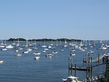
In and around the harbor there are 15 marinas, 13 private clubs with
boating facilities, and 5 commercial port facilities. There are more
than 1800 berthing spaces and more than 500 harbor mooring locations.
About 800 boats may be launched from storage racks at marinas and clubs
as well as via the city maintained launching ramp in Veterans Park.
More than 2700 commercial vessel trips to and from the harbor occur each year.
The main harbor channel is small enough to restrict the size of
vessels that could attempt to use it. In 2001 waterborne
commerce in the harbor totaled 512000 short tons (464,478.6 t). Typical freight
included fuel oil
, sand
, gravel
, stone
, and shellfish (particularly oyster
s and lobster
s).

 From the sound the main approach to the harbor lies to the southwest of Rowayton and
Sheffield Island. The wider and deeper southwest approach is also known as
"Sheffield Harbor", whereas the narrower and shallower eastern approach is known as "Cockenoe Harbor.
There is a 4.7 miles (7.6 km)-long channel extending from the outer harbor to the head of
the harbor in Norwalk. The channel is 12 feet (3.7 m) deep and 200 feet (61 m) wide
from the outer harbor to Gregory Point in East Norwalk
, where it narrows
to 150 feet (45.7 m) wide up to the wharves at South Norwalk. The channel then
widens to 250 feet (76.2 m) along the wharves to the Washington Street (Stroffolino) Bridge.
Upstream of the Washington street bridge the inner harbor lies along 1.5 miles (2.4 km) of the river. The channel of the inner harbor is 10 feet (3 m) deep and between
100–200 ft (30.5–61 m) wide until it terminates at the head of the harbor at the Wall Street bridge in central Norwalk. There is an anchorage area 10 feet (3 m) deep and 17 acres (6.9 ha) in area on the east side of the channel in the vicinity of Fitch Point in East Norwalk. There is also a 0.6 mile (0.965604 km)-long, six-foot-deep channel, 125–150 ft (38.1–45.7 m) wide, extending northeast from the 10 feet (3 m) anchorage opposite Fitch Point to the head of the harbor at East Norwalk. Another six-foot-deep anchorage area lies adjacent to the head of the harbor at East Norwalk.
There are no bridges across the outer harbor or the approach channels.
 In 1614 Dutch
navigator Adriaen Block
explored the Connecticut coast aboard the Onrust
and mapped the
Norwalk Islands
which lie at the outer boundary of the harbor. He referred
to the group of islands as the "Archipelago
".
As an aid to navigation at the harbor channel entrance the
Sheffield Island Light
was operational by 1826 (on what was called "Smith Island" at the time).
In 1872 the U.S. Army Corps of Engineers
started
its first work on harbor improvements in Norwalk.
On January 21, 1897, the United States Congress agreed to spend $73,100.00 on aids to navigation
in Norwalk Harbor including lights and fog signals. As a result of the expenditure Greens Ledge Light
was operational by 1902 and
Pecks Ledge Light
was operational by 1906. The Sheffield Island light was discontinued
as a federally maintained aid to navigation when the Greens Ledge Light was activated.
The Ischoda Yacht Club was founded in 1886 along the western shore of Norwalk Harbor in
South Norwalk and is among America's oldest Yacht Clubs. The Norwalk Yacht Club was formed in
August 1894 in Wilson's Cove.
The U.S. Army Corps of Engineers dredged the harbor in 1950.
In October 1955 a great flood washed down the Norwalk River and
destroyed many of the buildings adjacent to the riverbanks.
Today's Freese Park along Main Avenue was a built up commercial block
before October 1955. The flood left a wake of destruction in the harbor
that took a long time to recover from.
The Connecticut Turnpike was built over the river in 1956-1958.
The salt marsh just south of the Yankee Doodle bridge on the river's
west bank was turned into a garbage dump, but has since been closed, capped,
and turned into "Oyster Shell Park" (not to be confused with the
native Siwanoy
shell middens across the river on the east bank near "Oyster bend").
The Norwalk Harbor Commission was established in 1984 by the
Norwalk City Council. The commission is responsible for
maintaining a Harbor Management plan that includes maintaining
the safe navigation in the harbor, policies for the harbor master,
the promotion of the harbor, and the maintenance of the Visitors
dock at Veterans Park.
The U.S. Army Corps of Engineers finished harbor re-dredging projects in 1980 and again in 2006.
There will be a new dredging project for the inner and river portions of the harbor.
In the spring of 2007 the Marine Unit of the Norwalk Police department
launched a new 38 feet (11.6 m) police boat the Riva.
On July 10, 2007 the Norwalk Fire Department commissioned
its first fireboat the Harry Bower named to honor a fire fighter who died in 2005. In the fall of 2007 the harbor was visited by the
Seafair a 228 feet (69.5 m) motor yacht. The visit of the Seafair was
accompanied by private viewings of objects in the vessel's art galleries.
A utility project in the fall of 2007 replaced an electric power transmission line that runs
from Connecticut to Long Island. Seven fluid-filled cables originally laid in
1969 were replaced with three new solid dielectric cables.
The existing cables are joined at the oil-fired electric generating
substation on Manressa Island in Norwalk Harbor. From there, they cross
under Norwalk Harbor and Long Island Sound to connect at the Long Island Power Authority
’s
substation in the village of Northport, New York
. The three new 11 miles (17.7 km) long cables were buried at least one fathom (2 m) below the Sound’s bottom.
The Skyline Princess, a 120 feet (36.6 m)
motor yacht out of New York, makes port of call stops at Veterans Park.
trap falls gneisses and Harrison Gneiss with dark minerals hornblende
, biotite
and garnet
. The bedrock has two folds in the harbor area. The earlier, more southerly one was formed at the same time as the Taconic Mountains
. That fault runs from Bell Island through Manresa Island to Sprite Island. The second (created during the Acadian mountain-building event of 485–440 million years ago) runs along a line north from Noroton Point on Sheffield Island Harbor toward Exit 15 on Interstate 95.
Harbor
A harbor or harbour , or haven, is a place where ships, boats, and barges can seek shelter from stormy weather, or else are stored for future use. Harbors can be natural or artificial...
and seaport
at the estuary
Estuary
An estuary is a partly enclosed coastal body of water with one or more rivers or streams flowing into it, and with a free connection to the open sea....
of the Norwalk River
Norwalk River
The Norwalk River is a river in southwestern Connecticut, approximately long. The word "Norwalk" comes from the Algonquian word "noyank" meaning "point of land".-Description:...
where it flows into Long Island Sound
Long Island Sound
Long Island Sound is an estuary of the Atlantic Ocean, located in the United States between Connecticut to the north and Long Island, New York to the south. The mouth of the Connecticut River at Old Saybrook, Connecticut, empties into the sound. On its western end the sound is bounded by the Bronx...
in Norwalk
Norwalk, Connecticut
Norwalk is a city in Fairfield County, Connecticut, United States. According to the 2010 U.S. Census, the population of the city is 85,603, making Norwalk sixth in population in Connecticut, and third in Fairfield County...
, Connecticut
Connecticut
Connecticut is a state in the New England region of the northeastern United States. It is bordered by Rhode Island to the east, Massachusetts to the north, and the state of New York to the west and the south .Connecticut is named for the Connecticut River, the major U.S. river that approximately...
, United States
United States
The United States of America is a federal constitutional republic comprising fifty states and a federal district...
.
The last portion of the Norwalk River from the head of navigation
near Wall Street in Central Norwalk
Central Norwalk
The Central or Midtown section of Norwalk, Connecticut is an urbanized area in roughly the geographic center of the city, north of the South Norwalk neighborhood and the Connecticut Turnpike. Wall Street, West Avenue and Belden Avenue are the main thoroughfares...
to the Long Island Sound
Long Island Sound
Long Island Sound is an estuary of the Atlantic Ocean, located in the United States between Connecticut to the north and Long Island, New York to the south. The mouth of the Connecticut River at Old Saybrook, Connecticut, empties into the sound. On its western end the sound is bounded by the Bronx...
forms Norwalk Harbor. It is a federal navigation channel of the
"recreational and small commercial harbor" variety.
In and around the harbor there are 15 marinas, 13 private clubs with
boating facilities, and 5 commercial port facilities. There are more
than 1800 berthing spaces and more than 500 harbor mooring locations.
About 800 boats may be launched from storage racks at marinas and clubs
as well as via the city maintained launching ramp in Veterans Park.
More than 2700 commercial vessel trips to and from the harbor occur each year.
The main harbor channel is small enough to restrict the size of
vessels that could attempt to use it. In 2001 waterborne
commerce in the harbor totaled 512000 short tons (464,478.6 t). Typical freight
included fuel oil
Fuel oil
Fuel oil is a fraction obtained from petroleum distillation, either as a distillate or a residue. Broadly speaking, fuel oil is any liquid petroleum product that is burned in a furnace or boiler for the generation of heat or used in an engine for the generation of power, except oils having a flash...
, sand
Sand
Sand is a naturally occurring granular material composed of finely divided rock and mineral particles.The composition of sand is highly variable, depending on the local rock sources and conditions, but the most common constituent of sand in inland continental settings and non-tropical coastal...
, gravel
Gravel
Gravel is composed of unconsolidated rock fragments that have a general particle size range and include size classes from granule- to boulder-sized fragments. Gravel can be sub-categorized into granule and cobble...
, stone
Rock (geology)
In geology, rock or stone is a naturally occurring solid aggregate of minerals and/or mineraloids.The Earth's outer solid layer, the lithosphere, is made of rock. In general rocks are of three types, namely, igneous, sedimentary, and metamorphic...
, and shellfish (particularly oyster
Oyster
The word oyster is used as a common name for a number of distinct groups of bivalve molluscs which live in marine or brackish habitats. The valves are highly calcified....
s and lobster
Lobster
Clawed lobsters comprise a family of large marine crustaceans. Highly prized as seafood, lobsters are economically important, and are often one of the most profitable commodities in coastal areas they populate.Though several groups of crustaceans are known as lobsters, the clawed lobsters are most...
s).
Description
Sheffield Island. The wider and deeper southwest approach is also known as
"Sheffield Harbor", whereas the narrower and shallower eastern approach is known as "Cockenoe Harbor.
There is a 4.7 miles (7.6 km)-long channel extending from the outer harbor to the head of
the harbor in Norwalk. The channel is 12 feet (3.7 m) deep and 200 feet (61 m) wide
from the outer harbor to Gregory Point in East Norwalk
East Norwalk
East Norwalk is a neighborhood located in Norwalk, Connecticut.The neighborhood is a culturally diverse, mostly middle-class section of the city, inhabited by many different ethnicities such as Greeks, Italians, Hispanics, African Americans, and long time "Connecticut Yankee" residents...
, where it narrows
to 150 feet (45.7 m) wide up to the wharves at South Norwalk. The channel then
widens to 250 feet (76.2 m) along the wharves to the Washington Street (Stroffolino) Bridge.
Upstream of the Washington street bridge the inner harbor lies along 1.5 miles (2.4 km) of the river. The channel of the inner harbor is 10 feet (3 m) deep and between
100–200 ft (30.5–61 m) wide until it terminates at the head of the harbor at the Wall Street bridge in central Norwalk. There is an anchorage area 10 feet (3 m) deep and 17 acres (6.9 ha) in area on the east side of the channel in the vicinity of Fitch Point in East Norwalk. There is also a 0.6 mile (0.965604 km)-long, six-foot-deep channel, 125–150 ft (38.1–45.7 m) wide, extending northeast from the 10 feet (3 m) anchorage opposite Fitch Point to the head of the harbor at East Norwalk. Another six-foot-deep anchorage area lies adjacent to the head of the harbor at East Norwalk.
List of inner harbor crossings
From the head of navigation at Wall Street traveling out to the outer harbor there are:- Wall Street Bridge is an arch bridgeArch bridgeAn arch bridge is a bridge with abutments at each end shaped as a curved arch. Arch bridges work by transferring the weight of the bridge and its loads partially into a horizontal thrust restrained by the abutments at either side...
in Central NorwalkCentral NorwalkThe Central or Midtown section of Norwalk, Connecticut is an urbanized area in roughly the geographic center of the city, north of the South Norwalk neighborhood and the Connecticut Turnpike. Wall Street, West Avenue and Belden Avenue are the main thoroughfares... - Yankee Doodle Bridge is a girder bridgeGirder bridgeA girder bridge, in general, is a bridge built of girders placed on bridge abutments and foundation piers. In turn, a bridge deck is built on top of the girders in order to carry traffic. There are several different subtypes of girder bridges:...
that carries the Connecticut TurnpikeConnecticut TurnpikeThe Connecticut Turnpike, known now as the Governor John Davis Lodge Turnpike, is a freeway in Connecticut that runs from Greenwich to Killingly. It is signed as Interstate 95 from the New York state line at Greenwich to East Lyme, and then as Interstate 395 from East Lyme to Plainfield... - Norwalk River Railroad BridgeNorwalk River Railroad BridgeThe Norwalk River Railroad Bridge — the Amtrak and Metro-North Railroad right-of-way over the Norwalk River was built in 1896, when the route was widened to four tracks...
four track swing bridgeSwing bridgeA swing bridge is a movable bridge that has as its primary structural support a vertical locating pin and support ring, usually at or near to its centre of gravity, about which the turning span can then pivot horizontally as shown in the animated illustration to the right...
of AmtrakAmtrakThe National Railroad Passenger Corporation, doing business as Amtrak , is a government-owned corporation that was organized on May 1, 1971, to provide intercity passenger train service in the United States. "Amtrak" is a portmanteau of the words "America" and "track". It is headquartered at Union...
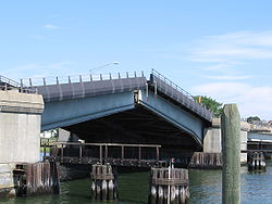
and the Metro-North RailroadMetro-North RailroadThe Metro-North Commuter Railroad , trading as MTA Metro-North Railroad, or, more commonly, Metro-North, is a suburban commuter rail service that is run and managed by the Metropolitan Transportation Authority , an authority of New York State. It is the busiest commuter railroad in the United... - Washington Street, Stroffolino memorial, is a bascule bridgeBascule bridgeA bascule bridge is a moveable bridge with a counterweight that continuously balances the span, or "leaf," throughout the entire upward swing in providing clearance for boat traffic....
that carries Route 136Connecticut Route 136Route 136 is a state highway in southwestern Connecticut, running from Darien to Easton. The route was initially established in 1932 to serve the beach communities between Darien and Southport...
There are no bridges across the outer harbor or the approach channels.
History
Netherlands
The Netherlands is a constituent country of the Kingdom of the Netherlands, located mainly in North-West Europe and with several islands in the Caribbean. Mainland Netherlands borders the North Sea to the north and west, Belgium to the south, and Germany to the east, and shares maritime borders...
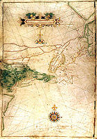
navigator Adriaen Block
Adriaen Block
Adriaen Block was a Dutch private trader and navigator who is best known for exploring the coastal and river valley areas between present-day New Jersey and Massachusetts during four voyages from 1611 to 1614, following the 1609 expedition by Henry Hudson...
explored the Connecticut coast aboard the Onrust
Onrust
The Onrust was a Dutch ship that was built by Adriaen Block and the crew of the Tyger, which had been destroyed by fire. The ship, a yacht, was the first decked vessel to be built entirely in America. The construction took one winter on Manhattan Island...
and mapped the
Norwalk Islands
Norwalk Islands
The Norwalk Islands are a chain of more than 25 islands amid partly submerged boulders, reefs and mudflats along a six-mile stretch and mostly about a mile off the coast of Norwalk, Connecticut and southwest Westport, Connecticut, in Long Island Sound.The islands are used for several different...
which lie at the outer boundary of the harbor. He referred
to the group of islands as the "Archipelago
Archipelago
An archipelago , sometimes called an island group, is a chain or cluster of islands. The word archipelago is derived from the Greek ἄρχι- – arkhi- and πέλαγος – pélagos through the Italian arcipelago...
".
As an aid to navigation at the harbor channel entrance the
Sheffield Island Light
Sheffield Island Light
Sheffield Island Light is an historic Connecticut, USA, lighthouse located at the southern end of the Norwalk Islands on the west entrance of the Norwalk River on northern Long Island Sound....
was operational by 1826 (on what was called "Smith Island" at the time).
In 1872 the U.S. Army Corps of Engineers
United States Army Corps of Engineers
The United States Army Corps of Engineers is a federal agency and a major Army command made up of some 38,000 civilian and military personnel, making it the world's largest public engineering, design and construction management agency...
started
its first work on harbor improvements in Norwalk.
On January 21, 1897, the United States Congress agreed to spend $73,100.00 on aids to navigation
in Norwalk Harbor including lights and fog signals. As a result of the expenditure Greens Ledge Light
Greens Ledge Light
Greens Ledge Lighthouse is a sparkplug lighthouse in Connecticut,United States, off the southwest end of the Norwalk Islands, Long Island Sound, near Norwalk, Connecticut...
was operational by 1902 and
Pecks Ledge Light
Pecks Ledge Light
Pecks Ledge Light, also known as "Peck Ledge Lighthouse", is a sparkplug lighthouse in Norwalk, Connecticut, United States, southeast of Norwalk Harbor and northeast of Goose Island among the Norwalk Islands on Long Island Sound...
was operational by 1906. The Sheffield Island light was discontinued
as a federally maintained aid to navigation when the Greens Ledge Light was activated.
The Ischoda Yacht Club was founded in 1886 along the western shore of Norwalk Harbor in
South Norwalk and is among America's oldest Yacht Clubs. The Norwalk Yacht Club was formed in
August 1894 in Wilson's Cove.
The U.S. Army Corps of Engineers dredged the harbor in 1950.
In October 1955 a great flood washed down the Norwalk River and
destroyed many of the buildings adjacent to the riverbanks.
Today's Freese Park along Main Avenue was a built up commercial block
before October 1955. The flood left a wake of destruction in the harbor
that took a long time to recover from.
The Connecticut Turnpike was built over the river in 1956-1958.
The salt marsh just south of the Yankee Doodle bridge on the river's
west bank was turned into a garbage dump, but has since been closed, capped,
and turned into "Oyster Shell Park" (not to be confused with the
native Siwanoy
Siwanoy
The Native American Siwanoy or Sinanoy were a band of Algonquian-speaking people, the Wappinger, in what is now the New York City area. By the mid-17th century, when their territory became hotly contested between Dutch and English colonial interests, the Siwanoy were settled along the East River...
shell middens across the river on the east bank near "Oyster bend").
The Norwalk Harbor Commission was established in 1984 by the
Norwalk City Council. The commission is responsible for
maintaining a Harbor Management plan that includes maintaining
the safe navigation in the harbor, policies for the harbor master,
the promotion of the harbor, and the maintenance of the Visitors
dock at Veterans Park.
The U.S. Army Corps of Engineers finished harbor re-dredging projects in 1980 and again in 2006.
There will be a new dredging project for the inner and river portions of the harbor.
In the spring of 2007 the Marine Unit of the Norwalk Police department
launched a new 38 feet (11.6 m) police boat the Riva.
On July 10, 2007 the Norwalk Fire Department commissioned
its first fireboat the Harry Bower named to honor a fire fighter who died in 2005. In the fall of 2007 the harbor was visited by the
Seafair a 228 feet (69.5 m) motor yacht. The visit of the Seafair was
accompanied by private viewings of objects in the vessel's art galleries.
A utility project in the fall of 2007 replaced an electric power transmission line that runs
from Connecticut to Long Island. Seven fluid-filled cables originally laid in
1969 were replaced with three new solid dielectric cables.
The existing cables are joined at the oil-fired electric generating
substation on Manressa Island in Norwalk Harbor. From there, they cross
under Norwalk Harbor and Long Island Sound to connect at the Long Island Power Authority
Long Island Power Authority
The Long Island Power Authority or LIPA [ "lie-pah" ], a municipal subdivision of the State of New York, was created under the Long Island Power Act of 1985 to acquire the Long Island Lighting Company 's assets and securities...
’s
substation in the village of Northport, New York
Northport, New York
Northport is a village in Suffolk County, New York on the North Shore of Long Island. As of the United States 2000 Census, the village population was 7,606. Students attend the Northport-East Northport Union Free School District....
. The three new 11 miles (17.7 km) long cables were buried at least one fathom (2 m) below the Sound’s bottom.
The Skyline Princess, a 120 feet (36.6 m)
motor yacht out of New York, makes port of call stops at Veterans Park.
Geology
The harbor is a "drowned river valley" flooded as the sea rose at the end of the last ice age. Bedrock under the harbor and in the Harborview and Calf Pasture Beach area is interlayered OrdovicianOrdovician
The Ordovician is a geologic period and system, the second of six of the Paleozoic Era, and covers the time between 488.3±1.7 to 443.7±1.5 million years ago . It follows the Cambrian Period and is followed by the Silurian Period...
trap falls gneisses and Harrison Gneiss with dark minerals hornblende
Hornblende
Hornblende is a complex inosilicate series of minerals .It is not a recognized mineral in its own right, but the name is used as a general or field term, to refer to a dark amphibole....
, biotite
Biotite
Biotite is a common phyllosilicate mineral within the mica group, with the approximate chemical formula . More generally, it refers to the dark mica series, primarily a solid-solution series between the iron-endmember annite, and the magnesium-endmember phlogopite; more aluminous endmembers...
and garnet
Garnet
The garnet group includes a group of minerals that have been used since the Bronze Age as gemstones and abrasives. The name "garnet" may come from either the Middle English word gernet meaning 'dark red', or the Latin granatus , possibly a reference to the Punica granatum , a plant with red seeds...
. The bedrock has two folds in the harbor area. The earlier, more southerly one was formed at the same time as the Taconic Mountains
Taconic Mountains
The Taconic Mountains or Taconic Range are a physiographic section of the larger New England province and part of the Appalachian Mountains, running along the eastern border of New York State and adjacent New England from northwest Connecticut to western Massachusetts, north to central western...
. That fault runs from Bell Island through Manresa Island to Sprite Island. The second (created during the Acadian mountain-building event of 485–440 million years ago) runs along a line north from Noroton Point on Sheffield Island Harbor toward Exit 15 on Interstate 95.
See also
- Calf Pasture BeachCalf Pasture BeachCalf Pasture Beach is an historically significant park and beach in East Norwalk, Connecticut along Long Island Sound.The area of the park lands is approximately ....
- East NorwalkEast NorwalkEast Norwalk is a neighborhood located in Norwalk, Connecticut.The neighborhood is a culturally diverse, mostly middle-class section of the city, inhabited by many different ethnicities such as Greeks, Italians, Hispanics, African Americans, and long time "Connecticut Yankee" residents...
- Maritime Aquarium at NorwalkMaritime Aquarium at NorwalkThe Maritime Aquarium at Norwalk is an aquarium located in the South Norwalk section of Norwalk, Connecticut....
- Norwalk IslandsNorwalk IslandsThe Norwalk Islands are a chain of more than 25 islands amid partly submerged boulders, reefs and mudflats along a six-mile stretch and mostly about a mile off the coast of Norwalk, Connecticut and southwest Westport, Connecticut, in Long Island Sound.The islands are used for several different...
- Norwalk Oyster Festival
- Norwalk RiverNorwalk RiverThe Norwalk River is a river in southwestern Connecticut, approximately long. The word "Norwalk" comes from the Algonquian word "noyank" meaning "point of land".-Description:...
- South Norwalk
- Stewart B. McKinney National Wildlife RefugeStewart B. McKinney National Wildlife RefugeThe Stewart B. McKinney National Wildlife Refuge is a National Wildlife Refuge in ten units across the U.S. state of Connecticut. Located in the Atlantic Flyway, the refuge spans of Connecticut coastline and provides important resting, feeding, and nesting habitat for many species of wading...
External links
- Fairfieldcountyonline Norwalk Harbor webcam
- University of Connecticut remote sensor
- Norwalk River Watershed Association
- Harbor Watch/River Watch at Earthplace, Westport, Connecticut
- Norwalk River Rowing Association
- U.S. Environmental Protection Agency Superfund site at Manresa Island Power Plant
- Norwalk Sailing School at Calf Pasture Beach
- U.S. Coast Guard Flotilla 72 at Calf Pasture Beach
- Norwalk Seaport Association