

North West Highlands Geopark
Encyclopedia
International Network of Geoparks
The Global Geoparks Network is a UNESCO programme established in 1998. Managed under the body’s Ecological and Earth Sciences Division, the GGN seeks the promotion and conservation of the planet’s geological heritage, as well as encourages the sustainable research and development by the concerned...
in the Scottish Highlands
Scottish Highlands
The Highlands is an historic region of Scotland. The area is sometimes referred to as the "Scottish Highlands". It was culturally distinguishable from the Lowlands from the later Middle Ages into the modern period, when Lowland Scots replaced Scottish Gaelic throughout most of the Lowlands...
. Awarded UNESCO
UNESCO
The United Nations Educational, Scientific and Cultural Organization is a specialized agency of the United Nations...
geopark status in 2004, it features some of the oldest rocks in Europe
Europe
Europe is, by convention, one of the world's seven continents. Comprising the westernmost peninsula of Eurasia, Europe is generally 'divided' from Asia to its east by the watershed divides of the Ural and Caucasus Mountains, the Ural River, the Caspian and Black Seas, and the waterways connecting...
, around 3,000 million years old. The park contains many notable geological features, such as the Moine Thrust Belt
Moine Thrust Belt
The Moine Thrust Belt is a linear geological feature in the Scottish Highlands which runs from Loch Eriboll on the north coast 190 km south-west to the Sleat peninsula on the Isle of Skye...
and Smoo Cave
Smoo Cave
Smoo Cave is a large combined sea cave and freshwater cave in Durness in Sutherland, Highland, Scotland.- Geology :Smoo Cave is formed within Early Ordovician dolostones of the Durness Group...
.
Geography
The park is located in the extreme north-west of ScotlandScotland
Scotland is a country that is part of the United Kingdom. Occupying the northern third of the island of Great Britain, it shares a border with England to the south and is bounded by the North Sea to the east, the Atlantic Ocean to the north and west, and the North Channel and Irish Sea to the...
and includes parts of Sutherland
Sutherland
Sutherland is a registration county, lieutenancy area and historic administrative county of Scotland. It is now within the Highland local government area. In Gaelic the area is referred to according to its traditional areas: Dùthaich 'IcAoidh , Asainte , and Cataibh...
and Wester Ross
Wester Ross
is a western area of Ross and Cromarty in Scotland, notably containing the villages on the west coast such as:* Lochcarron* Applecross* Shieldaig* Torridon* Kinlochewe * * * Aultbea* Laide* Ullapool* Achiltibuie...
, including Cape Wrath
Cape Wrath
Cape Wrath is a cape in Sutherland, Highland, in northern Scotland. It is the most northwesterly point on the island of Great Britain. The land between the Kyle of Durness and the lighthouse that is situated right at the tip, is known as the Parph, two hundred and seven square kilometers of...
. The area is one of the most sparsely inhabited in Europe
Europe
Europe is, by convention, one of the world's seven continents. Comprising the westernmost peninsula of Eurasia, Europe is generally 'divided' from Asia to its east by the watershed divides of the Ural and Caucasus Mountains, the Ural River, the Caspian and Black Seas, and the waterways connecting...
, and is largely treeless. The park's eastern boundary generally follows the Moine Thrust Belt, otherwise the park is generally bounded by the north and west coasts of Scotland, with a few islands included in the park, such as the Summer Isles
Summer Isles
The Summer Isles are an archipelago lying in the mouth of Loch Broom, in the Highland region of Scotland.-Geography:The only inhabited isle, Tanera Mòr, is also the largest. It is home to an Atlantic salmon fish farm, some rental holiday homes, a café and a post office, which has operated its own...
.
Notable features
Precambrian
The Precambrian is the name which describes the large span of time in Earth's history before the current Phanerozoic Eon, and is a Supereon divided into several eons of the geologic time scale...
Moine rocks
Moine Supergroup
The Moine Supergroup is a sequence of Neoproterozoic metamorphic rocks that form the dominant outcrop of the Scottish Highlands between the Moine Thrust Belt to the northwest and the Great Glen Fault to the southeast. The sequence is metasedimentary in nature and was metamorphosed and deformed in a...
which have been pushed on top of younger Cambrian
Cambrian
The Cambrian is the first geological period of the Paleozoic Era, lasting from Mya ; it is succeeded by the Ordovician. Its subdivisions, and indeed its base, are somewhat in flux. The period was established by Adam Sedgwick, who named it after Cambria, the Latin name for Wales, where Britain's...
and Ordovician
Ordovician
The Ordovician is a geologic period and system, the second of six of the Paleozoic Era, and covers the time between 488.3±1.7 to 443.7±1.5 million years ago . It follows the Cambrian Period and is followed by the Silurian Period...
rocks, much to the surprise of Victorian
Victorian era
The Victorian era of British history was the period of Queen Victoria's reign from 20 June 1837 until her death on 22 January 1901. It was a long period of peace, prosperity, refined sensibilities and national self-confidence...
geologists. A debate ensued between prominent geologists of the time. Roderick Murchison
Roderick Murchison
Sir Roderick Impey Murchison, 1st Baronet KCB DCL FRS FRSE FLS PRGS PBA MRIA was a Scottish geologist who first described and investigated the Silurian system.-Early life and work:...
and Archibald Geikie
Archibald Geikie
Sir Archibald Geikie, OM, KCB, PRS, FRSE , was a Scottish geologist and writer.-Early life:Geikie was born in Edinburgh in 1835, the eldest son of musician and music critic James Stuart Geikie...
argued that the Moine rocks must in fact be younger than the rocks beneath them, a point of view opposed by James Nicol and Charles Lapworth
Charles Lapworth
Charles Lapworth was an English geologist.-Biography:He was born at Faringdon in Berkshire and educated as a teacher at the Culham Diocesan Training College near Abingdon, Oxfordshire. He moved to the Scottish border region, where he investigated the previously little-known fossil fauna of the area...
. The controversy was resolved by Ben Peach
Ben Peach
Benjamin Neeve Peach, FRS was a British geologist.He was born at Gorran Haven in Cornwall to Charles William Peach, an amateur British naturalist and geologist. Ben was educated at the Royal School of Mines in London and then joined the Geological Survey in 1862 as a geologist, moving to the...
and John Horne
John Horne
John Horne was a Scottish geologist. He was elected a Fellow of the Royal Society in 1900. He was a pupil of Ben Peach....
who found that the Moine rocks had been pushed some 70 kilometres east over the top of the younger rocks by tectonic action. This was the first thrust fault
Thrust fault
A thrust fault is a type of fault, or break in the Earth's crust across which there has been relative movement, in which rocks of lower stratigraphic position are pushed up and over higher strata. They are often recognized because they place older rocks above younger...
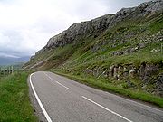
to be discovered. A monument to the pair is located within the park. Its inscription reads: To Ben N Peach and John Horne who played the foremost part in unravelling the geological structure of the North West Highlands 1883-1897. An international tribute. Erected 1980. The faultline can be seen most easily at a line of cliffs named Knockan Crag
Knockan Crag
Knockan Crag is a line of cliffs in Assynt, Scotland north of Ullapool. The name is an anglicisation of the Gaelic Creag a' Chnocain meaning 'crag of the small hill'....
. This crag
Cliff
In geography and geology, a cliff is a significant vertical, or near vertical, rock exposure. Cliffs are formed as erosion landforms due to the processes of erosion and weathering that produce them. Cliffs are common on coasts, in mountainous areas, escarpments and along rivers. Cliffs are usually...
is where the Moine is where the apparent anomaly in the ages of the rocks was first seen, and is where the thrust belt was first identified. A visitor's centre is located here, as well as several pieces of sculpture created by modern artists.
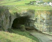
The area contains a number of limestone caves. The most well known of these is Smoo Cave
Smoo Cave
Smoo Cave is a large combined sea cave and freshwater cave in Durness in Sutherland, Highland, Scotland.- Geology :Smoo Cave is formed within Early Ordovician dolostones of the Durness Group...
, a large sea cave near Durness
Durness
Durness is a huge but remote parish in the northwestern Highlands of Scotland, encompassing all the land between the Moine to the East and the Gualin to the West...
. This cave is unique within the UK in that its outer chamber was formed by the action of seawater, while the inner chambers were formed by fresh water. Its entrance 15 metres high, is the largest entrance of any sea cave in the British Isles
British Isles
The British Isles are a group of islands off the northwest coast of continental Europe that include the islands of Great Britain and Ireland and over six thousand smaller isles. There are two sovereign states located on the islands: the United Kingdom of Great Britain and Northern Ireland and...
. Archaeological excavations have found evidence of human habitation dating back to the Mesolithic
Mesolithic
The Mesolithic is an archaeological concept used to refer to certain groups of archaeological cultures defined as falling between the Paleolithic and the Neolithic....
period. The cave became well known after Sir Walter Scott
Walter Scott
Sir Walter Scott, 1st Baronet was a Scottish historical novelist, playwright, and poet, popular throughout much of the world during his time....
visited it in 1814. Another notable cave site is the Inchnadamph
Inchnadamph
Inchnadamph is a hamlet in Assynt, Sutherland, Scotland. The name is an anglicisation of the Gaelic name Innis nan Damh meaning 'meadow of the stags'...
Bone Caves. At these caves, remains of Eurasian Lynx
Eurasian Lynx
The Eurasian lynx is a medium-sized cat native to European and Siberian forests, South Asia and East Asia. It is also known as the European lynx, common lynx, the northern lynx, and the Siberian or Russian lynx...
, Brown Bear
Brown Bear
The brown bear is a large bear distributed across much of northern Eurasia and North America. It can weigh from and its largest subspecies, the Kodiak Bear, rivals the polar bear as the largest member of the bear family and as the largest land-based predator.There are several recognized...
, Arctic Fox
Arctic fox
The arctic fox , also known as the white fox, polar fox or snow fox, is a small fox native to Arctic regions of the Northern Hemisphere and is common throughout the Arctic tundra biome. The Greek word alopex, means a fox and Vulpes is the Latin version...
, Reindeer
Reindeer
The reindeer , also known as the caribou in North America, is a deer from the Arctic and Subarctic, including both resident and migratory populations. While overall widespread and numerous, some of its subspecies are rare and one has already gone extinct.Reindeer vary considerably in color and size...
and Polar Bear
Polar Bear
The polar bear is a bear native largely within the Arctic Circle encompassing the Arctic Ocean, its surrounding seas and surrounding land masses. It is the world's largest land carnivore and also the largest bear, together with the omnivorous Kodiak Bear, which is approximately the same size...
s have been found; as well as human remains dated between 4,515 and 4,720 years old.
Cape Wrath
Cape Wrath is a cape in Sutherland, Highland, in northern Scotland. It is the most northwesterly point on the island of Great Britain. The land between the Kyle of Durness and the lighthouse that is situated right at the tip, is known as the Parph, two hundred and seven square kilometers of...
, the northwesternmost point on the Scottish mainland, which features the highest vertical cliffs in mainland Britain. Another feature is the Old Man of Stoer
Old Man of Stoer
The Old Man of Stoer is a high sea stack of Torridonian sandstone in Sutherland, Highland, Scotland, close to the Marilyn Sidhean Mor, the villages of Culkein and Stoer and the nearby Point of Stoer...
, a sandstone sea stack
Stack (geology)
A stack is a geological landform consisting of a steep and often vertical column or columns of rock in the sea near a coast, isolated by erosion. Stacks are formed through processes of coastal geomorphology, which are entirely natural. Time, wind and water are the only factors involved in the...
located off the Point of Stoer in Assynt
Assynt
Assynt is a civil parish in west Sutherland, Highland, Scotland – north of Ullapool.It is famous for its landscape and its remarkable mountains...
.
Mountains
The Moine Thrust Belt is regarded as the northwest boundary of the CaledonianCaledonian orogeny
The Caledonian orogeny is a mountain building era recorded in the northern parts of the British Isles, the Scandinavian Mountains, Svalbard, eastern Greenland and parts of north-central Europe. The Caledonian orogeny encompasses events that occurred from the Ordovician to Early Devonian, roughly...
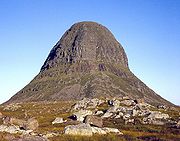
mountain belt. However, a few mountains exist within the park, some of which are well known. The highly distinctive Suilven
Suilven
Suilven is one of the most distinctive mountains in Scotland. Lying in a remote area in the west of Sutherland, it rises almost vertically from a wilderness landscape of moorland, bogs and lochans known as Inverpolly National Nature Reserve....
is perhaps the most notable mountain within the park, and its image is used in promotional material. Other mountains to be found here include Stac Pollaidh
Stac Pollaidh
Stac Pollaidh is a mountain in the Northwest Highlands of Scotland. The peak displays a rocky crest of Torridonian sandstone, with many pinnacles and steep gullies. The crest is extremely weathered , suggesting that it was not covered in ice during the last Ice Age.The name Stac Pollaidh is often...
, Canisp
Canisp
Canisp is a mountain in the far north west of Scotland. It is situated in the parish of Assynt, in the county of Sutherland, 25 kilometres north of the town of Ullapool. Canisp reaches a height of 847 metres and qualifies as a Corbett and Marilyn hill...
, Quinag
Quinag
The mountain Quinag in Sutherland, in the Scottish Highlands, is in fact a mountain range with an undulating series of peaks along its Y-shaped crest...
, Foinaven
Foinaven
Foinaven is a mountain in Scotland, situated in the far north-west corner of the Scottish Highlands. Like many of the monolithic mountains that surround it, the mountain is within the Moine Thrust Belt and is made up of imbricated layers of Cambrian quartzite which overlie the older Lewisian...
and Arkle
Arkle (hill)
Arkle is a mountain in Sutherland, situated in the far north-west corner of the Scottish Highlands. Like its sister Foinaven, the mountain is made up of glistening white Cambrian quartzite, laid down around 530 million years ago on an uneven basement of much older Lewisian gneiss...
.
Geology

- Lewisian GneissLewisian complexThe Lewisian complex or Lewisian Gneiss is a suite of Precambrian metamorphic rocks that outcrop in the northwestern part of Scotland, forming part of the Hebridean Terrane. These rocks are of Archaean and Paleoproterozoic age, ranging from 3.0–1.7 Ga. They form the basement on which the...
– Metamorphic rockMetamorphic rockMetamorphic rock is the transformation of an existing rock type, the protolith, in a process called metamorphism, which means "change in form". The protolith is subjected to heat and pressure causing profound physical and/or chemical change...
s, ranging from pink to grey-green in colour, depending on the rock they were originally formed from. Around 3,000 million years old, making them the oldest rocks in Britain, and, along with similar rocks in BulgariaBulgariaBulgaria , officially the Republic of Bulgaria , is a parliamentary democracy within a unitary constitutional republic in Southeast Europe. The country borders Romania to the north, Serbia and Macedonia to the west, Greece and Turkey to the south, as well as the Black Sea to the east...
, FinlandFinlandFinland , officially the Republic of Finland, is a Nordic country situated in the Fennoscandian region of Northern Europe. It is bordered by Sweden in the west, Norway in the north and Russia in the east, while Estonia lies to its south across the Gulf of Finland.Around 5.4 million people reside...
, the Lofoten Islands of NorwayNorwayNorway , officially the Kingdom of Norway, is a Nordic unitary constitutional monarchy whose territory comprises the western portion of the Scandinavian Peninsula, Jan Mayen, and the Arctic archipelago of Svalbard and Bouvet Island. Norway has a total area of and a population of about 4.9 million...
, and RussiaRussiaRussia or , officially known as both Russia and the Russian Federation , is a country in northern Eurasia. It is a federal semi-presidential republic, comprising 83 federal subjects...
, among the oldest in Europe. - TorridonianTorridonianIn geology, Torridonian describes a series of Neoproterozoic arenaceous sedimentary rocks, extensively developed in the Northwest Highlands of Scotland, and particularly in the district of upper Loch Torridon, a circumstance which suggested the name Torridon Sandstone, first applied to these rocks...
SandstoneSandstoneSandstone is a sedimentary rock composed mainly of sand-sized minerals or rock grains.Most sandstone is composed of quartz and/or feldspar because these are the most common minerals in the Earth's crust. Like sand, sandstone may be any colour, but the most common colours are tan, brown, yellow,...
– red-brown, coarse. Around 1,000 million years old. Many of the area's mountains are composed of this rock. - Basal QuartziteQuartziteQuartzite is a hard metamorphic rock which was originally sandstone. Sandstone is converted into quartzite through heating and pressure usually related to tectonic compression within orogenic belts. Pure quartzite is usually white to gray, though quartzites often occur in various shades of pink...
– White to pink quartzite. Some of this contains fossilized worm burrows and is known as pipe rock. c. 500 million years old. Largely located within and around the park's thrust faultThrust faultA thrust fault is a type of fault, or break in the Earth's crust across which there has been relative movement, in which rocks of lower stratigraphic position are pushed up and over higher strata. They are often recognized because they place older rocks above younger...
s. - Durness LimestoneLimestoneLimestone is a sedimentary rock composed largely of the minerals calcite and aragonite, which are different crystal forms of calcium carbonate . Many limestones are composed from skeletal fragments of marine organisms such as coral or foraminifera....
– Pale to dark grey in colour. Around 480 million years old. Also located within and around thrust faults. Often contains caves, such as Smoo Cave and the Inchnadamph Bone CavesInchnadamphInchnadamph is a hamlet in Assynt, Sutherland, Scotland. The name is an anglicisation of the Gaelic name Innis nan Damh meaning 'meadow of the stags'...
. - Moine Rocks – Metamorphosed sandstone and mudstoneMudstoneMudstone is a fine grained sedimentary rock whose original constituents were clays or muds. Grain size is up to 0.0625 mm with individual grains too small to be distinguished without a microscope. With increased pressure over time the platey clay minerals may become aligned, with the...
. Around 980 million years old. Concentrated at the eastern edge of the park, as these rocks tend to be found to the east of the Moine Thrust Belt. - Igneous rocks – Granite, syenite, porphyry; containing feldspar and quartz. Various ages. A comparatively rare type of rock in the park, which largely contains metamorphic and sedimentary rocks.
See also
- International Network of GeoparksInternational Network of GeoparksThe Global Geoparks Network is a UNESCO programme established in 1998. Managed under the body’s Ecological and Earth Sciences Division, the GGN seeks the promotion and conservation of the planet’s geological heritage, as well as encourages the sustainable research and development by the concerned...
- List of Geoparks
- Sustainable tourismSustainable tourismSustainable tourism is tourism attempting to make a low impact on the environment and local culture, while helping to generate future employment for local people. The aim of sustainable tourism is to ensure that development brings a positive experience for local people, tourism companies and the...