
Durness
Encyclopedia
Durness is a huge but remote parish in the northwestern Highland
s of Scotland
, encompassing all the land between the Moine to the East (separating it from Tongue parish) and the Gualin to the West (separating it from Eddrachilis). No one knows for sure where the name derives; it has variously been translated as from "Dorainn nis" tempest point, or "Dhu thir nis" the point of the black land; or from the Norse for deerpoint. Or even from the main village "Durine" which would translate as "Dhu Rinn" the black (or fertile) promontory, with the Norse "ness" tacked on to an existing Gaelic name. The parish comprises a number of larger or smaller townships, from the east these including Kempie, Eriboll, Laid, Rispond, Ceannabeinne
, Sangobeg, Lerin, Smoo, Sangomore, Durine, Balvulich, Balnakeil, Achins and Keoldale. To the west there are also the single homesteads of Grudie, Carbreck and Rigolter.
Durness was formerly a part of the bishopric of Caithness and the old house at Balnakeil was originally the Bishop's summer residence. The church at Balnakeil dates back to the Culdean monks but the existing ruined church is said to have been built by the monks from Dornoch Cathedral in the 13th century (it is also said that they discovered gold around Durness but no finds have been reported since).
The parish of Durness was for centuries a part of Duibhich Mhic Aoidh, the land of the Clan Mackay
, who held their title to the land extending from Melvich in the East to Kylesku in the West; it was said that at his most powerful the Chief of Mackay could call on 4,000 fighting men when required.
Sadly the population today is much diminished; the whole of the Durness area suffered greatly from the Highland Clearances, the first in 1819 and thereafter throughout the greater part of the 19th century until the Crofting Act of the 1886 finally gave crofters a measure of security of tenure. The Durness Riots of 1846 were caused by such clearances when the women of Ceannabeinne
area defied the Sheriff's Officer sent to deliver the summons of eviction and subsequent disorder occurred in the village inn in Durness when a second attempt was made, causing the officers to be again run out of town ingloriously.
Until some 50 years ago, Durness was a predominantly Gaelic speaking area but today there are only one or two people who can even speak moderately well in the language. The whole culture which endured for centuries has finally been extirpated and though there are now serious attempts to teach Gaelic in schools and recreate an interest in the language, the distinctive dialect of Mackay Country is all but lost.
Which is doubly sad, as Durness is also the birthplace of one of the greatest Gaelic poets of all time, Rob Donn Calder (some argue "Mackay"), born at Achnacaillich in Strathmore in 1714 and a keen and fearless observer of people and situations. Although illiterate and monolingual he was steeped in the rich Gaelic culture of his time and was responsible for some of the finest Gaelic songs, verses and elegies ever created. Rob Donn has been called the Gaelic Robert Burns, and not without justification. Anyone wishing to understand the depth of his thought would be well to read "The World of Rob Donn" by Ian Grimble which, although inevitably stilted because of the inability to convert the fluidity and subtlety of Gaelic verse into the more prosaic English, still does a marvellous job in giving a glimpse into this cattle herder's intellectual genius.
The main sources of employment in the village are crofting
and tourism
. It is the largest village in the northwestern corner of Scotland, has a population of around 400, and is on the main A836-A838 road between the towns of Thurso
(116 km (72 mi) to the east) and Ullapool
(109 km (68 mi) to the south). This area is notable for being the most sparsely populated region in Western Europe.
Although being a former seat of the Clan Mackay, there is a large contingent of the Clan Morrison in the area which causes some in the locale to question the idea of calling the area “Mackay Country”. That said, in historic terms, the Morrisons are fairly recent incomers (the Mackays having been in the area since the 11th century). The Morrisons came over from Ness in Lewis in the 16th century as part of the marriage settlement by the Bishop of Caithness to the son of the Chief of the clan Morrison on the occasion of his marriage to the Bishop's daughter. The Bishop gave the lands of Eddrachilis and Durness to the young couple and the young Morrison translated 40 families from Ness to his new acquisitions on the mainland. These folk landed, it is said, initially at Portlovorochy (Port-sluagh-Murraichidh "The Port of the Followers of Morrison) and fanned out up the coast to Kinlochbervie and Durness where they remain in significant numbers to this day.
-Ordovician
carbonates known as the Durness Group, also erroneously known as the ‘Durness Limestone’. These carbonates are also found in Assynt
and extend as far south as Skye
although the full sequence can only be seen in the Durness area, hence the name of the unit. This thick sequence (c. 800 m) of dolostone
s with subordinate limestone
s and chert
s is softer than the surrounding hills which are formed of more resistant Lewisian Gneiss
/ Torridonian sandstones, sometimes capped by Cambrian Quartzite
. Therefore the local area is generally flatter, low lying and more fertile than other areas in the North West Highlands due to the lime-rich bedrock and resultant soils.
An incredible variety of other rock types for such a small area can be found around the village due to extensive faulting in the area placing different rocks of different ages (Archaean - Ordovician
) side by side. The Moine Thrust
itself can also be seen in the area at Faraid Head
and Sango Bay despite the main thrust area being found several kilometres east at Loch Eriboll
. The thrust exposures within Sango Bay are the most easily accessible localities to see such features of the Moine Thrust Zone, as well as the bay itself (geologically a graben
) showing one of the best examples of basin bounding faults in the British Isles.
Faraid Head is also important geologically for one of Scotland's largest sand dune systems where the prominent headland is exposed to strong winds, building sand dunes up to 60m above sea level. The cliffs on the eastern side of this headland show the only preserved exposures of Moine
metasediment
s west of the main outcrop of the Moine Thrust in Scotland (as a result of thrusting and later normal-faulting) and excellent machair examples have developed between the cliff top and the dunes, partly due to the high sea-shell content of the sands in the Durness area.
As a result of all the forementioned, Durness is a popular destination for undergraduate geology
students as well as tourists, mainly during the summer months.
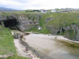
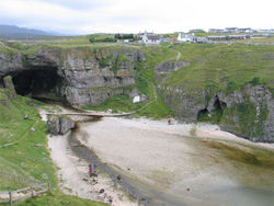 The main attractions in Durness are Smoo Cave
, a conjoined sea cave and freshwater cave with a small river running through it and a waterfall
in wet weather, unspoilt beaches backed by cliffs, and the local sea bird
s, seal
s, porpoise
s and minke whale
s. The surrounding coastline is some of Europe's most isolated and spectacular, with the nearby Clo Mor Cliffs being the highest on the British mainland, at some 281 m (921 ft) high.
The area has been inhabited since stone age times and there are many places of historic interest; one of the most interesting but only for the serious walker is "Carn Righ", on the northmost tip of Ben Spionnaidh, which is a manmade cairn celebrating a long dead petty king or chief from the area, whether Pict or Viking now unknown; but the reason for the site chosen is clear as the site overlooks all his lands.
Balnakiel Old Church, itself of great historical interest, has inside its wall the grave of Donuill Mac Morraichaidh, a serial bandit and murderer who sought exculpation from his sins by paying to be buried inside one wall of the church so, it is said "that his enemies couldn't walk over his grave".
The area around Loch Croispol and Loch Borrallie abounds in archeological interest, from brochs to round houses to medieval and pre-clearances settlements; the Old School at Croispol has been recently excavated and a host of interesting information garnered by the local schoolmaster and enthusiastic historian, Graham Bruce. Incidentally, the name "Loch Croispol" itself is of interest in that it suggests that the local gallows "croich" was situated nearby when the Chief of Mackay held the right of pit and gallows.
Out on the Faraid Head is Seannachaisteal, presumably a broch, but it is now completely enveloped in sand and no dig has ever been carried out to see what it was and from which time in history. A few years ago, the body of a young Viking boy was discovered exposed by the erosion of the sand dunes at Faraid. And at Sangobeg beach, the body of a Pictish boy was discovered.
At Ceinnabeinne, on the left of the road as you leave Durness towards Tongue, lies "Clach a Breitheanas" or the Judgement Stone. This was said to be where judgement was meted out to malefactors and those found guilty were thrown over the cliff to their doom below. While folklore does not identify when this was done, the method of execution is much more Pictish, who had a penchant for natural means of death, than Viking, where a swift axe was the favoured means of disposal. Whatever the history, it was obviously an important place, as three stones round the main stone have very obviously been polished as seats, one very evidently cut in the rock and polished. and as this is Lewisian Gneiss, the effort of polishing these rocks points to use for a very significant purpose.
Polished by the Durness youth as part of an arts project with assistance from the local stone carver.
In the substantial sand dunes to the north of the village, a large colony of puffin
s can be approached to within less than 10 metres, offering superb opportunity for wildlife photography
. Rock pipit
s also live on the beach.
Another tourist spot is the local Balnakeil Craft Village, a rather picturesque old Royal Air Force
(RAF) radar base from the Cold War
era. The villagers mainly live sustainably and there is a community ethos, with some rather wonderful and eccentric characters selling arts and crafts goods and providing an interesting stop for visitors.
The village is also used as a base by visitors to Cape Wrath
.
In 2007 Durness hosted the John Lennon Northern Lights Festival, a celebration of music, poetry, theatre and other cultural activities in celebration of the spirit of John Lennon
who enjoyed boyhood summers in the village. Lennon returned for a visit in 1969 with Yoko Ono and their children but the visit was cut short when Lennon drove his car off the road by Loch Eribol. The track In My Life
from Rubber Soul
is said to be based on a poem about Durness which Lennon wrote on a teenage holiday in the area, although most of the original poem's meaning was lost during songwriting with McCartney. A small shrubby garden has been dedicated to John Lennon in the centre of the village and the house where he stayed during his holidays still stands.
and USAF
aircraft. A rocky islet resembling a ship is used for bombing practice. Although explosions can be heard, and seen with binoculars
, they are sufficiently far away to avoid disturbing the colonies of sea bird
s. It is the only military firing range in the U.K. where aircraft are allowed to deliver 1000-pound bombs.
A few miles east of Durness lies Loch Eriboll
, known for its otter
s and minke whale
s. During World War II
it was used to station naval troops, and the island in its centre was used as a bombing target for the subsequent attack on the Tirpitz in Norway, as it resembles a battleship
. The loch is sometimes used as a safe harbour by large ships during stormy weather.
The loch also hosted, if that is the word, the battle fleet of King Hakkon of Norway on his way south to the disastrous (for the Norwegians) battle of Largs
in 1266; the small harbour of Portnacon has variously been translated as "Port na coin" "the port of the dogs" or a corruption of "Port Hakkon", "Hakkon's Port". During the Second World War, the battle cruiser "Jamaica" sustained an outbreak of measles on board and it was quarantined in Loch Eriboll for months, lest the contagion spread and affect the navy generally and possibly delay the Normandy landings; and at cessation of hostilities in 1945 it saw the surrender of some 30 German U-boats.
During World War II
, the RAF built a Chain Home
radar
station at Sango near Durness. There was also a Chain Home Low
radar
station at Sango. After the war there was also a ROTOR
radar station near Durness part of which is used by the modern military range and the accommodation area is used for various crafts.
Scottish Highlands
The Highlands is an historic region of Scotland. The area is sometimes referred to as the "Scottish Highlands". It was culturally distinguishable from the Lowlands from the later Middle Ages into the modern period, when Lowland Scots replaced Scottish Gaelic throughout most of the Lowlands...
s of Scotland
Scotland
Scotland is a country that is part of the United Kingdom. Occupying the northern third of the island of Great Britain, it shares a border with England to the south and is bounded by the North Sea to the east, the Atlantic Ocean to the north and west, and the North Channel and Irish Sea to the...
, encompassing all the land between the Moine to the East (separating it from Tongue parish) and the Gualin to the West (separating it from Eddrachilis). No one knows for sure where the name derives; it has variously been translated as from "Dorainn nis" tempest point, or "Dhu thir nis" the point of the black land; or from the Norse for deerpoint. Or even from the main village "Durine" which would translate as "Dhu Rinn" the black (or fertile) promontory, with the Norse "ness" tacked on to an existing Gaelic name. The parish comprises a number of larger or smaller townships, from the east these including Kempie, Eriboll, Laid, Rispond, Ceannabeinne
Ceannabeinne
Ceannabeinne is a ruined village within the parish of Durness, in the county of Sutherland, in the far north of the Highlands of Scotland....
, Sangobeg, Lerin, Smoo, Sangomore, Durine, Balvulich, Balnakeil, Achins and Keoldale. To the west there are also the single homesteads of Grudie, Carbreck and Rigolter.
Durness was formerly a part of the bishopric of Caithness and the old house at Balnakeil was originally the Bishop's summer residence. The church at Balnakeil dates back to the Culdean monks but the existing ruined church is said to have been built by the monks from Dornoch Cathedral in the 13th century (it is also said that they discovered gold around Durness but no finds have been reported since).
The parish of Durness was for centuries a part of Duibhich Mhic Aoidh, the land of the Clan Mackay
Clan MacKay
Clan Mackay is an ancient and once powerful Scottish clan from the far north of the Scottish Highlands, but with roots in the old kingdom of Moray. They were a powerful force in politics beginning in the 14th century, supporting Robert the Bruce. In the centuries that followed they were...
, who held their title to the land extending from Melvich in the East to Kylesku in the West; it was said that at his most powerful the Chief of Mackay could call on 4,000 fighting men when required.
Sadly the population today is much diminished; the whole of the Durness area suffered greatly from the Highland Clearances, the first in 1819 and thereafter throughout the greater part of the 19th century until the Crofting Act of the 1886 finally gave crofters a measure of security of tenure. The Durness Riots of 1846 were caused by such clearances when the women of Ceannabeinne
Ceannabeinne
Ceannabeinne is a ruined village within the parish of Durness, in the county of Sutherland, in the far north of the Highlands of Scotland....
area defied the Sheriff's Officer sent to deliver the summons of eviction and subsequent disorder occurred in the village inn in Durness when a second attempt was made, causing the officers to be again run out of town ingloriously.
Until some 50 years ago, Durness was a predominantly Gaelic speaking area but today there are only one or two people who can even speak moderately well in the language. The whole culture which endured for centuries has finally been extirpated and though there are now serious attempts to teach Gaelic in schools and recreate an interest in the language, the distinctive dialect of Mackay Country is all but lost.
Which is doubly sad, as Durness is also the birthplace of one of the greatest Gaelic poets of all time, Rob Donn Calder (some argue "Mackay"), born at Achnacaillich in Strathmore in 1714 and a keen and fearless observer of people and situations. Although illiterate and monolingual he was steeped in the rich Gaelic culture of his time and was responsible for some of the finest Gaelic songs, verses and elegies ever created. Rob Donn has been called the Gaelic Robert Burns, and not without justification. Anyone wishing to understand the depth of his thought would be well to read "The World of Rob Donn" by Ian Grimble which, although inevitably stilted because of the inability to convert the fluidity and subtlety of Gaelic verse into the more prosaic English, still does a marvellous job in giving a glimpse into this cattle herder's intellectual genius.
The main sources of employment in the village are crofting
Croft (land)
A croft is a fenced or enclosed area of land, usually small and arable with a crofter's dwelling thereon. A crofter is one who has tenure and use of the land, typically as a tenant farmer.- Etymology :...
and tourism
Tourism
Tourism is travel for recreational, leisure or business purposes. The World Tourism Organization defines tourists as people "traveling to and staying in places outside their usual environment for not more than one consecutive year for leisure, business and other purposes".Tourism has become a...
. It is the largest village in the northwestern corner of Scotland, has a population of around 400, and is on the main A836-A838 road between the towns of Thurso
Thurso
-Facilities:Offices of the Highland Council are located in the town, as is the main campus of North Highland College, formerly Thurso College. This is one of several partner colleges which constitute the UHI Millennium Institute, and offers several certificate, diploma and degree courses from...
(116 km (72 mi) to the east) and Ullapool
Ullapool
Ullapool is a small town of around 1,300 inhabitants in Ross and Cromarty, Highland, Scotland. Despite its small size, it is the largest settlement for many miles around, and is a major tourist destination of Scotland. The North Atlantic Drift passes by Ullapool, bringing moderate temperatures...
(109 km (68 mi) to the south). This area is notable for being the most sparsely populated region in Western Europe.
Although being a former seat of the Clan Mackay, there is a large contingent of the Clan Morrison in the area which causes some in the locale to question the idea of calling the area “Mackay Country”. That said, in historic terms, the Morrisons are fairly recent incomers (the Mackays having been in the area since the 11th century). The Morrisons came over from Ness in Lewis in the 16th century as part of the marriage settlement by the Bishop of Caithness to the son of the Chief of the clan Morrison on the occasion of his marriage to the Bishop's daughter. The Bishop gave the lands of Eddrachilis and Durness to the young couple and the young Morrison translated 40 families from Ness to his new acquisitions on the mainland. These folk landed, it is said, initially at Portlovorochy (Port-sluagh-Murraichidh "The Port of the Followers of Morrison) and fanned out up the coast to Kinlochbervie and Durness where they remain in significant numbers to this day.
Geography / Geology
The landscape of the Durness area is a stark contrast to the surrounding areas due to a down-faulted, isolated wedge of CambroCambrian
The Cambrian is the first geological period of the Paleozoic Era, lasting from Mya ; it is succeeded by the Ordovician. Its subdivisions, and indeed its base, are somewhat in flux. The period was established by Adam Sedgwick, who named it after Cambria, the Latin name for Wales, where Britain's...
-Ordovician
Ordovician
The Ordovician is a geologic period and system, the second of six of the Paleozoic Era, and covers the time between 488.3±1.7 to 443.7±1.5 million years ago . It follows the Cambrian Period and is followed by the Silurian Period...
carbonates known as the Durness Group, also erroneously known as the ‘Durness Limestone’. These carbonates are also found in Assynt
Assynt
Assynt is a civil parish in west Sutherland, Highland, Scotland – north of Ullapool.It is famous for its landscape and its remarkable mountains...
and extend as far south as Skye
Skye
Skye or the Isle of Skye is the largest and most northerly island in the Inner Hebrides of Scotland. The island's peninsulas radiate out from a mountainous centre dominated by the Cuillin hills...
although the full sequence can only be seen in the Durness area, hence the name of the unit. This thick sequence (c. 800 m) of dolostone
Dolostone
Dolostone or dolomite rock is a sedimentary carbonate rock that contains a high percentage of the mineral dolomite. In old U.S.G.S. publications it was referred to as magnesian limestone. Most dolostone formed as a magnesium replacement of limestone or lime mud prior to lithification. It is...
s with subordinate limestone
Limestone
Limestone is a sedimentary rock composed largely of the minerals calcite and aragonite, which are different crystal forms of calcium carbonate . Many limestones are composed from skeletal fragments of marine organisms such as coral or foraminifera....
s and chert
Chert
Chert is a fine-grained silica-rich microcrystalline, cryptocrystalline or microfibrous sedimentary rock that may contain small fossils. It varies greatly in color , but most often manifests as gray, brown, grayish brown and light green to rusty red; its color is an expression of trace elements...
s is softer than the surrounding hills which are formed of more resistant Lewisian Gneiss
Lewisian complex
The Lewisian complex or Lewisian Gneiss is a suite of Precambrian metamorphic rocks that outcrop in the northwestern part of Scotland, forming part of the Hebridean Terrane. These rocks are of Archaean and Paleoproterozoic age, ranging from 3.0–1.7 Ga. They form the basement on which the...
/ Torridonian sandstones, sometimes capped by Cambrian Quartzite
Quartzite
Quartzite is a hard metamorphic rock which was originally sandstone. Sandstone is converted into quartzite through heating and pressure usually related to tectonic compression within orogenic belts. Pure quartzite is usually white to gray, though quartzites often occur in various shades of pink...
. Therefore the local area is generally flatter, low lying and more fertile than other areas in the North West Highlands due to the lime-rich bedrock and resultant soils.
An incredible variety of other rock types for such a small area can be found around the village due to extensive faulting in the area placing different rocks of different ages (Archaean - Ordovician
Ordovician
The Ordovician is a geologic period and system, the second of six of the Paleozoic Era, and covers the time between 488.3±1.7 to 443.7±1.5 million years ago . It follows the Cambrian Period and is followed by the Silurian Period...
) side by side. The Moine Thrust
Moine Thrust Belt
The Moine Thrust Belt is a linear geological feature in the Scottish Highlands which runs from Loch Eriboll on the north coast 190 km south-west to the Sleat peninsula on the Isle of Skye...
itself can also be seen in the area at Faraid Head
Faraid Head
Faraid Head is a small peninsula on the northern coast of Sutherland, Highland, Scotland, located two miles to the north of the village Balnakeil and three miles north of Durness....
and Sango Bay despite the main thrust area being found several kilometres east at Loch Eriboll
Loch Eriboll
Loch Eriboll is a long sea loch on the north coast of Scotland, which has been used for centuries as a deep water anchorage as it is safe from the often stormy seas of Cape Wrath and the Pentland Firth...
. The thrust exposures within Sango Bay are the most easily accessible localities to see such features of the Moine Thrust Zone, as well as the bay itself (geologically a graben
Graben
In geology, a graben is a depressed block of land bordered by parallel faults. Graben is German for ditch. Graben is used for both the singular and plural....
) showing one of the best examples of basin bounding faults in the British Isles.
Faraid Head is also important geologically for one of Scotland's largest sand dune systems where the prominent headland is exposed to strong winds, building sand dunes up to 60m above sea level. The cliffs on the eastern side of this headland show the only preserved exposures of Moine
Moine Supergroup
The Moine Supergroup is a sequence of Neoproterozoic metamorphic rocks that form the dominant outcrop of the Scottish Highlands between the Moine Thrust Belt to the northwest and the Great Glen Fault to the southeast. The sequence is metasedimentary in nature and was metamorphosed and deformed in a...
metasediment
Metasediment
In geology, metasediment is sediment or sedimentary rock that shows evidence of having been subjected to metamorphism. The overall composition of a metasediment can be used to identify the original sedimentary rock, even where they have been subject to high-grade metamorphism and intense...
s west of the main outcrop of the Moine Thrust in Scotland (as a result of thrusting and later normal-faulting) and excellent machair examples have developed between the cliff top and the dunes, partly due to the high sea-shell content of the sands in the Durness area.
As a result of all the forementioned, Durness is a popular destination for undergraduate geology
Geology
Geology is the science comprising the study of solid Earth, the rocks of which it is composed, and the processes by which it evolves. Geology gives insight into the history of the Earth, as it provides the primary evidence for plate tectonics, the evolutionary history of life, and past climates...
students as well as tourists, mainly during the summer months.
Attractions / Tourism
Smoo Cave
Smoo Cave is a large combined sea cave and freshwater cave in Durness in Sutherland, Highland, Scotland.- Geology :Smoo Cave is formed within Early Ordovician dolostones of the Durness Group...
, a conjoined sea cave and freshwater cave with a small river running through it and a waterfall
Waterfall
A waterfall is a place where flowing water rapidly drops in elevation as it flows over a steep region or a cliff.-Formation:Waterfalls are commonly formed when a river is young. At these times the channel is often narrow and deep. When the river courses over resistant bedrock, erosion happens...
in wet weather, unspoilt beaches backed by cliffs, and the local sea bird
Seabird
Seabirds are birds that have adapted to life within the marine environment. While seabirds vary greatly in lifestyle, behaviour and physiology, they often exhibit striking convergent evolution, as the same environmental problems and feeding niches have resulted in similar adaptations...
s, seal
Pinniped
Pinnipeds or fin-footed mammals are a widely distributed and diverse group of semiaquatic marine mammals comprising the families Odobenidae , Otariidae , and Phocidae .-Overview: Pinnipeds are typically sleek-bodied and barrel-shaped...
s, porpoise
Porpoise
Porpoises are small cetaceans of the family Phocoenidae; they are related to whales and dolphins. They are distinct from dolphins, although the word "porpoise" has been used to refer to any small dolphin, especially by sailors and fishermen...
s and minke whale
Minke Whale
Minke whale , or lesser rorqual, is a name given to two species of marine mammal belonging to a clade within the suborder of baleen whales. The minke whale was given its official designation by Lacepède in 1804, who described a dwarf form of Balænoptera acuto-rostrata...
s. The surrounding coastline is some of Europe's most isolated and spectacular, with the nearby Clo Mor Cliffs being the highest on the British mainland, at some 281 m (921 ft) high.
The area has been inhabited since stone age times and there are many places of historic interest; one of the most interesting but only for the serious walker is "Carn Righ", on the northmost tip of Ben Spionnaidh, which is a manmade cairn celebrating a long dead petty king or chief from the area, whether Pict or Viking now unknown; but the reason for the site chosen is clear as the site overlooks all his lands.
Balnakiel Old Church, itself of great historical interest, has inside its wall the grave of Donuill Mac Morraichaidh, a serial bandit and murderer who sought exculpation from his sins by paying to be buried inside one wall of the church so, it is said "that his enemies couldn't walk over his grave".
The area around Loch Croispol and Loch Borrallie abounds in archeological interest, from brochs to round houses to medieval and pre-clearances settlements; the Old School at Croispol has been recently excavated and a host of interesting information garnered by the local schoolmaster and enthusiastic historian, Graham Bruce. Incidentally, the name "Loch Croispol" itself is of interest in that it suggests that the local gallows "croich" was situated nearby when the Chief of Mackay held the right of pit and gallows.
Out on the Faraid Head is Seannachaisteal, presumably a broch, but it is now completely enveloped in sand and no dig has ever been carried out to see what it was and from which time in history. A few years ago, the body of a young Viking boy was discovered exposed by the erosion of the sand dunes at Faraid. And at Sangobeg beach, the body of a Pictish boy was discovered.
At Ceinnabeinne, on the left of the road as you leave Durness towards Tongue, lies "Clach a Breitheanas" or the Judgement Stone. This was said to be where judgement was meted out to malefactors and those found guilty were thrown over the cliff to their doom below. While folklore does not identify when this was done, the method of execution is much more Pictish, who had a penchant for natural means of death, than Viking, where a swift axe was the favoured means of disposal. Whatever the history, it was obviously an important place, as three stones round the main stone have very obviously been polished as seats, one very evidently cut in the rock and polished. and as this is Lewisian Gneiss, the effort of polishing these rocks points to use for a very significant purpose.
Polished by the Durness youth as part of an arts project with assistance from the local stone carver.
Catering
Tourists are catered for by a campsite spectacularly sited on the cliffs above the beach (with easy access down to the beach), an SYHA hostel, housed by some converted army buildings, bed and breakfast accommodation, and two hotels and restaurants, Mackay's and the Smoo Cave Hotel.In the substantial sand dunes to the north of the village, a large colony of puffin
Atlantic Puffin
The Atlantic Puffin is a seabird species in the auk family. It is a pelagic bird that feeds primarily by diving for fish, but also eats other sea creatures, such as squid and crustaceans. Its most obvious characteristic during the breeding season is its brightly coloured bill...
s can be approached to within less than 10 metres, offering superb opportunity for wildlife photography
Photography
Photography is the art, science and practice of creating durable images by recording light or other electromagnetic radiation, either electronically by means of an image sensor or chemically by means of a light-sensitive material such as photographic film...
. Rock pipit
Rock Pipit
The Rock Pipit, Anthus petrosus, is a small passerine bird species which breeds on rocky coasts of western Europe northwards from Brittany. It is mainly resident in Ireland, Great Britain and France, in the west of its range, but the Scandinavian and Russian populations migrate south in winter;...
s also live on the beach.
Another tourist spot is the local Balnakeil Craft Village, a rather picturesque old Royal Air Force
Royal Air Force
The Royal Air Force is the aerial warfare service branch of the British Armed Forces. Formed on 1 April 1918, it is the oldest independent air force in the world...
(RAF) radar base from the Cold War
Cold War
The Cold War was the continuing state from roughly 1946 to 1991 of political conflict, military tension, proxy wars, and economic competition between the Communist World—primarily the Soviet Union and its satellite states and allies—and the powers of the Western world, primarily the United States...
era. The villagers mainly live sustainably and there is a community ethos, with some rather wonderful and eccentric characters selling arts and crafts goods and providing an interesting stop for visitors.
The village is also used as a base by visitors to Cape Wrath
Cape Wrath
Cape Wrath is a cape in Sutherland, Highland, in northern Scotland. It is the most northwesterly point on the island of Great Britain. The land between the Kyle of Durness and the lighthouse that is situated right at the tip, is known as the Parph, two hundred and seven square kilometers of...
.
In 2007 Durness hosted the John Lennon Northern Lights Festival, a celebration of music, poetry, theatre and other cultural activities in celebration of the spirit of John Lennon
John Lennon
John Winston Lennon, MBE was an English musician and singer-songwriter who rose to worldwide fame as one of the founding members of The Beatles, one of the most commercially successful and critically acclaimed acts in the history of popular music...
who enjoyed boyhood summers in the village. Lennon returned for a visit in 1969 with Yoko Ono and their children but the visit was cut short when Lennon drove his car off the road by Loch Eribol. The track In My Life
In My Life
"In My Life" is a song by The Beatles written by John Lennon and Paul McCartney . The song originated with Lennon, and while Paul McCartney contributed to the final version, the extent of his contribution is in dispute. George Martin contributed the instrumental bridge...
from Rubber Soul
Rubber Soul
Rubber Soul is the sixth studio album by the English rock group The Beatles, released in December 1965. Produced by George Martin, Rubber Soul had been recorded in just over four weeks to make the Christmas market...
is said to be based on a poem about Durness which Lennon wrote on a teenage holiday in the area, although most of the original poem's meaning was lost during songwriting with McCartney. A small shrubby garden has been dedicated to John Lennon in the centre of the village and the house where he stayed during his holidays still stands.
Military Presence
Some miles to the north west lies a military firing range known as Garvie Range used by RAF, Royal NavyRoyal Navy
The Royal Navy is the naval warfare service branch of the British Armed Forces. Founded in the 16th century, it is the oldest service branch and is known as the Senior Service...
and USAF
United States Air Force
The United States Air Force is the aerial warfare service branch of the United States Armed Forces and one of the American uniformed services. Initially part of the United States Army, the USAF was formed as a separate branch of the military on September 18, 1947 under the National Security Act of...
aircraft. A rocky islet resembling a ship is used for bombing practice. Although explosions can be heard, and seen with binoculars
Binoculars
Binoculars, field glasses or binocular telescopes are a pair of identical or mirror-symmetrical telescopes mounted side-by-side and aligned to point accurately in the same direction, allowing the viewer to use both eyes when viewing distant objects...
, they are sufficiently far away to avoid disturbing the colonies of sea bird
Seabird
Seabirds are birds that have adapted to life within the marine environment. While seabirds vary greatly in lifestyle, behaviour and physiology, they often exhibit striking convergent evolution, as the same environmental problems and feeding niches have resulted in similar adaptations...
s. It is the only military firing range in the U.K. where aircraft are allowed to deliver 1000-pound bombs.
A few miles east of Durness lies Loch Eriboll
Loch Eriboll
Loch Eriboll is a long sea loch on the north coast of Scotland, which has been used for centuries as a deep water anchorage as it is safe from the often stormy seas of Cape Wrath and the Pentland Firth...
, known for its otter
Otter
The Otters are twelve species of semi-aquatic mammals which feed on fish and shellfish, and also other invertebrates, amphibians, birds and small mammals....
s and minke whale
Minke Whale
Minke whale , or lesser rorqual, is a name given to two species of marine mammal belonging to a clade within the suborder of baleen whales. The minke whale was given its official designation by Lacepède in 1804, who described a dwarf form of Balænoptera acuto-rostrata...
s. During World War II
World War II
World War II, or the Second World War , was a global conflict lasting from 1939 to 1945, involving most of the world's nations—including all of the great powers—eventually forming two opposing military alliances: the Allies and the Axis...
it was used to station naval troops, and the island in its centre was used as a bombing target for the subsequent attack on the Tirpitz in Norway, as it resembles a battleship
Battleship
A battleship is a large armored warship with a main battery consisting of heavy caliber guns. Battleships were larger, better armed and armored than cruisers and destroyers. As the largest armed ships in a fleet, battleships were used to attain command of the sea and represented the apex of a...
. The loch is sometimes used as a safe harbour by large ships during stormy weather.
The loch also hosted, if that is the word, the battle fleet of King Hakkon of Norway on his way south to the disastrous (for the Norwegians) battle of Largs
Battle of Largs
The Battle of Largs was an engagement fought between the armies of Norway and Scotland near the present-day town of Largs in North Ayrshire on the Firth of Clyde in Scotland on 2 October 1263. It was the most important military engagement of the Scottish-Norwegian War. The Norwegian forces were...
in 1266; the small harbour of Portnacon has variously been translated as "Port na coin" "the port of the dogs" or a corruption of "Port Hakkon", "Hakkon's Port". During the Second World War, the battle cruiser "Jamaica" sustained an outbreak of measles on board and it was quarantined in Loch Eriboll for months, lest the contagion spread and affect the navy generally and possibly delay the Normandy landings; and at cessation of hostilities in 1945 it saw the surrender of some 30 German U-boats.
During World War II
World War II
World War II, or the Second World War , was a global conflict lasting from 1939 to 1945, involving most of the world's nations—including all of the great powers—eventually forming two opposing military alliances: the Allies and the Axis...
, the RAF built a Chain Home
Chain Home
Chain Home was the codename for the ring of coastal Early Warning radar stations built by the British before and during the Second World War. The system otherwise known as AMES Type 1 consisted of radar fixed on top of a radio tower mast, called a 'station' to provide long-range detection of...
radar
Radar
Radar is an object-detection system which uses radio waves to determine the range, altitude, direction, or speed of objects. It can be used to detect aircraft, ships, spacecraft, guided missiles, motor vehicles, weather formations, and terrain. The radar dish or antenna transmits pulses of radio...
station at Sango near Durness. There was also a Chain Home Low
Chain Home Low
Chain Home Low was the name of a British radar early warning system, detecting enemy aircraft movement at lower altitudes than and summarily used with the fixed Chain Home system which was operated by the RAF during World War II...
radar
Radar
Radar is an object-detection system which uses radio waves to determine the range, altitude, direction, or speed of objects. It can be used to detect aircraft, ships, spacecraft, guided missiles, motor vehicles, weather formations, and terrain. The radar dish or antenna transmits pulses of radio...
station at Sango. After the war there was also a ROTOR
ROTOR
ROTOR was a huge and elaborate air defence radar system built by the British Government in the early 1950s to counter possible attack by Soviet bombers...
radar station near Durness part of which is used by the modern military range and the accommodation area is used for various crafts.