
New York State Route 78
Encyclopedia
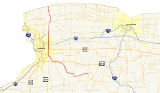
New York State Route 78 (NY 78), most commonly known as Transit Road, is a state highway
in Western New York
, USA. While it is signed north–south, the lower portion runs in an east–west direction across Wyoming County
, from its beginning north of the Village of Gainesville.
NY 78 is most closely identified in the region with Transit Road, a major north–south trunk road through the center of Erie County
and Niagara County
, although it does not follow Transit for its entire length, nor is Transit more than half its length.
In those two counties, Transit Road is a major road between the towns it passes. It joins Transit Road north of East Aurora
and stays with to its end in Lockport
.
, Transit Road, and the section north of Lockport
to Lake Ontario
.
. It heads due west, its north–south signage notwithstanding, across rural Wyoming County, its mostly straight route providing exciting dips and rises for the driver as it crosses the gently rolling uplands. At the hamlet of Hermitage, the route actually starts trending to the south. 78 is on this heading when it reaches its first junction, NY 362
west of Smiths Corners, running southward from there a short distance to Bliss.
A few miles further on, the southward trend stops. At Waldos Corners, 78 turns and for the first time runs north–south. This lasts only two miles NY 98
intersects from the north at Five Corners and the combined wrong-way concurrency is once again heading west. That situation ends at Java Center
, where 98 turns left to go south, NY 77
goes north and 78 continues straight ahead.
From this area, on clear days, the Buffalo
skyline is sometimes visible. 78 begins to descend from the Allegheny Plateau
as it once again turns north near Java Village and starts following the Buffalo Creek
valley into Erie County
. Shortly after crossing the county line, the road again begins to turn westward and finally returns to that orientation when it joins with US 20A
. Thus joined, the two routes intersect NY 400
, the Aurora Expressway, and enter the busy village of East Aurora
as Big Tree Road.
. The two routes parallel the 400 expressway until they reach Transit Road, at that point designated as US 20
. 78 turns north to join 20 while 16 continues toward the city.
Just north of this intersection is another cloverleaf interchange
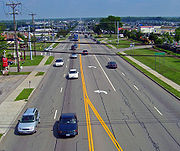
with NY 400. Serious development begins past this point, and Transit is often four lanes, dividing towns, for many miles past this point as it heads due north along the transit
line first surveyed
by Joseph Ellicott
of the Holland Land Company
. This road is named after the instrument used for establishing a very accurate line pointing towards true north
, the transit
.
20 and 78 have only one other state highway junction, at Clinton Street, with NY 354
, before 20 goes east while NY 130
goes west at the Broadway junction outside Depew
. Several miles to the north, a flurry of junctions with major regional roads — NY 33
, the New York State Thruway
(I-90
) and NY 5
, occur within two miles (3 km).
After the 5 junction, a busy traffic light, Transit passes the Eastern Hills Mall
. A gradual descent begins as Sheridan Drive, NY 324
, crosses on an overpass
just after the mall, and the road's inerrant, straight course ahead is briefly visible.
North of here, the development begins to ease and large strip malls vanish in favor of smaller mom-and-pop shops and restaurants. The road narrows again to two lanes as it enters the newly-trendy East Amherst area. There are no junctions with existing state highways until the Millersport Highway, NY 263
, comes in at an oblique angle from the south. After this, Transit begins once again to widen as it crosses the Tonawanda Creek
and enters Niagara County. NY 93
crosses just south of the city of Lockport
, and finally the miles-long Transit strip comes to an end just past the NY 31
junction and the Erie Canal
.
.
Beyond Wrights Corners, 78 continues north to the small village of Newfane
, slowly descending along with the terrain. It reaches its northern terminus at Olcott
, a small hamlet on the shore of Lake Ontario
once home to a small amusement park
but now a collection of cottage
s. After the junction with NY 18
, a short local street continues to the lake shore.
in Amherst
to the Lake Ontario
shoreline in Olcott
via Lockport
was originally designated as NY 32 in the mid-1920s. In the 1930 renumbering of state highways in New York, NY 32 became part of NY 78, a new route extending from Gainesville in the south to Olcott
in the north, mostly along existing but previously unnumbered roads. However, the portion between NY 362
and NY 19
was in the process of being built. NY 78's early routing was identical to its modern alignment except from East Aurora
to Depew
. Initially, NY 78 headed north from East Aurora on Maple Street, then used Jamison Road, Bowen Road, NY 354
, Aurora Street, and NY 35
to reach Transit Road in Depew.
Ca. 1932, NY 78 was realigned to follow U.S. Route 20 (now U.S. Route 20A
) west from East Aurora to Transit Road, where it turned north onto Transit Road and followed it to Depew. The former routing of NY 78 between East Aurora and Lancaster
was redesignated as NY 78A. NY 78 was rerouted one last time ca. 1939 to overlap with NY 16
northwest from East Aurora to its junction with Transit Road in West Seneca
. The realignment bypassed the southernmost portion of Transit Road, which became NY 187
in the early 1940s.
between NY 78 in East Aurora
and NY 35
(now U.S. Route 20) in Lancaster
. The route began at the modern intersection of Main (US 20) and Maple Streets in East Aurora and followed Maple Street, Jamison Road, Bowen Road, NY 354
, and Aurora Street to a terminus at Broadway Street (NY 35) in Lancaster. It was assigned ca. 1932 after NY 78 was rerouted to follow US 20 and Transit Road instead between East Aurora and Depew
. The NY 78A designation was short-lived as it was removed ca. 1938. Its routing is now part of several county routes as well as NY 354.
State highway
State highway, state road or state route can refer to one of three related concepts, two of them related to a state or provincial government in a country that is divided into states or provinces :#A...
in Western New York
Western New York
Western New York is the westernmost region of the state of New York. It includes the cities of Buffalo, Rochester, Niagara Falls, the surrounding suburbs, as well as the outlying rural areas of the Great Lakes lowlands, the Genesee Valley, and the Southern Tier. Some historians, scholars and others...
, USA. While it is signed north–south, the lower portion runs in an east–west direction across Wyoming County
Wyoming County, New York
Wyoming County is a county located in the U.S. state of New York. At the 2010 census, the population was 42,155. The county seat is Warsaw. The name is from a modified Delaware Indian word meaning "broad bottom lands"...
, from its beginning north of the Village of Gainesville.
NY 78 is most closely identified in the region with Transit Road, a major north–south trunk road through the center of Erie County
Erie County, New York
Erie County is a county located in the U.S. state of New York. As of the 2010 census, the population was 919,040. The county seat is Buffalo. The county's name comes from Lake Erie, which in turn comes from the Erie tribe of American Indians who lived south and east of the lake before 1654.Erie...
and Niagara County
Niagara County, New York
Niagara County is a county located in the U.S. state of New York. As of the 2010 census, the population was 216,469. The county seat is Lockport. The county name is from the Iroquois word Onguiaahra; meaning the strait or thunder of waters. It is the location of Niagara Falls and Fort Niagara, and...
, although it does not follow Transit for its entire length, nor is Transit more than half its length.
In those two counties, Transit Road is a major road between the towns it passes. It joins Transit Road north of East Aurora
East Aurora, New York
East Aurora is a village in Erie County, New York, United States, southeast of Buffalo. The Village of East Aurora lies in the eastern half of the Town of Aurora.The population was 6,673 at the 2000 census...
and stays with to its end in Lockport
Lockport (city), New York
Lockport is a city in Niagara County, New York, United States. The population was 21,165 at the 2010 census. The name is derived from a set of Erie canal locks within the city. Lockport is the county seat of Niagara County and is surrounded by the town of Lockport...
.
Route description
Route 78 can be divided into three main segments: the east–west section mostly in Wyoming CountyWyoming County, New York
Wyoming County is a county located in the U.S. state of New York. At the 2010 census, the population was 42,155. The county seat is Warsaw. The name is from a modified Delaware Indian word meaning "broad bottom lands"...
, Transit Road, and the section north of Lockport
Lockport (city), New York
Lockport is a city in Niagara County, New York, United States. The population was 21,165 at the 2010 census. The name is derived from a set of Erie canal locks within the city. Lockport is the county seat of Niagara County and is surrounded by the town of Lockport...
to Lake Ontario
Lake Ontario
Lake Ontario is one of the five Great Lakes of North America. It is bounded on the north and southwest by the Canadian province of Ontario, and on the south by the American state of New York. Ontario, Canada's most populous province, was named for the lake. In the Wyandot language, ontarío means...
.
Wyoming County to East Aurora
78 begins just north of the small village of Gainesville, at a junction with NY 19New York State Route 19
New York State Route 19 is a north–south state highway in Western New York in the United States. It is the longest state highway in that region, and the only other one besides NY 14 to completely transect the state from the Pennsylvania state line to the shore of Lake Ontario...
. It heads due west, its north–south signage notwithstanding, across rural Wyoming County, its mostly straight route providing exciting dips and rises for the driver as it crosses the gently rolling uplands. At the hamlet of Hermitage, the route actually starts trending to the south. 78 is on this heading when it reaches its first junction, NY 362
New York State Route 362
New York State Route 362 is a short state highway located entirely in Wyoming County. It runs north–south between NY 39 just south of Bliss to NY 78 two miles to the north. Route 362 was assigned in 1930.-Route description:Route 362 begins at an intersection with...
west of Smiths Corners, running southward from there a short distance to Bliss.
A few miles further on, the southward trend stops. At Waldos Corners, 78 turns and for the first time runs north–south. This lasts only two miles NY 98
New York State Route 98
New York State Route 98 is a state highway in the western part of New York in the United States. The southern terminus of the route is at an intersection with U.S. Route 219 in the town of Great Valley in Cattaraugus County...
intersects from the north at Five Corners and the combined wrong-way concurrency is once again heading west. That situation ends at Java Center
Java, New York
Java is a town in Wyoming County, New York, United States. The population was 2,222 at the 2000 census. In the 2007 estimate, this had declined to 2,153.Contrary to practice elsewhere, the name is pronounced "Jay-vuh"....
, where 98 turns left to go south, NY 77
New York State Route 77
New York State Route 77 is a north–south state highway in the western part of New York in the United States. The highway runs for across mostly rural areas from an intersection with NY 78 and NY 98 in the Wyoming County town of Java to a junction with NY 31 near the city of...
goes north and 78 continues straight ahead.
From this area, on clear days, the Buffalo
Buffalo, New York
Buffalo is the second most populous city in the state of New York, after New York City. Located in Western New York on the eastern shores of Lake Erie and at the head of the Niagara River across from Fort Erie, Ontario, Buffalo is the seat of Erie County and the principal city of the...
skyline is sometimes visible. 78 begins to descend from the Allegheny Plateau
Allegheny Plateau
The Allegheny Plateau is a large dissected plateau area in western and central New York, northern and western Pennsylvania, northern and western West Virginia, and eastern Ohio...
as it once again turns north near Java Village and starts following the Buffalo Creek
Buffalo Creek
-Waterways:In Pennsylvania*Buffalo Creek *Buffalo Creek , tributary of the Casselman River*Buffalo Creek *Buffalo Creek In West Virginia...
valley into Erie County
Erie County, New York
Erie County is a county located in the U.S. state of New York. As of the 2010 census, the population was 919,040. The county seat is Buffalo. The county's name comes from Lake Erie, which in turn comes from the Erie tribe of American Indians who lived south and east of the lake before 1654.Erie...
. Shortly after crossing the county line, the road again begins to turn westward and finally returns to that orientation when it joins with US 20A
U.S. Route 20A (New York)
U.S. Route 20A is an east–west alternate route of US 20 that extends for across the western portion of New York in the United States. It leaves US 20 in Hamburg, a suburb of Buffalo, and rejoins it in East Bloomfield about five miles west of Canandaigua, the county seat of...
. Thus joined, the two routes intersect NY 400
New York State Route 400
New York State Route 400 is a state highway located within Erie County, New York, in the United States. The northwest end is connected to the New York State Thruway and the southeast end terminates at NY 16 in the town of Aurora. NY 400, a limited-access highway, roughly parallels...
, the Aurora Expressway, and enter the busy village of East Aurora
East Aurora, New York
East Aurora is a village in Erie County, New York, United States, southeast of Buffalo. The Village of East Aurora lies in the eastern half of the Town of Aurora.The population was 6,673 at the 2000 census...
as Big Tree Road.
Transit Road
Route 20A parts company with 78 after East Aurora, but it nevertheless leaves the village still overlapped, this time with NY 16New York State Route 16
New York State Route 16 is a state highway in western New York, United States. It runs from the Pennsylvania state line, where it is one of the highest highways in the state in elevation, to downtown Buffalo. NY 16 is a major route through Erie County, despite the construction of the...
. The two routes parallel the 400 expressway until they reach Transit Road, at that point designated as US 20
U.S. Route 20
U.S. Route 20 is an east–west United States highway. As the "0" in its route number implies, US 20 is a coast-to-coast route. Spanning , it is the longest road in the United States, and the route sparsely parallels Interstate 90...
. 78 turns north to join 20 while 16 continues toward the city.
Just north of this intersection is another cloverleaf interchange
Cloverleaf interchange
A cloverleaf interchange is a two-level interchange in which left turns, reverse direction in left-driving regions, are handled by ramp roads...
with NY 400. Serious development begins past this point, and Transit is often four lanes, dividing towns, for many miles past this point as it heads due north along the transit
Theodolite
A theodolite is a precision instrument for measuring angles in the horizontal and vertical planes. Theodolites are mainly used for surveying applications, and have been adapted for specialized purposes in fields like metrology and rocket launch technology...
line first surveyed
Surveying
See Also: Public Land Survey SystemSurveying or land surveying is the technique, profession, and science of accurately determining the terrestrial or three-dimensional position of points and the distances and angles between them...
by Joseph Ellicott
Joseph Ellicott
Joseph Ellicott was an American surveyor, city planner, land office agent, lawyer and politician of the Quaker faith.-Life:He was the son of Joseph Ellicott ....
of the Holland Land Company
Holland Land Company
The Holland Land Company was a purchaser of the western two-thirds of the western New York land tract known as the Phelps and Gorham Purchase. This tract was known thereafter as The Holland Purchase...
. This road is named after the instrument used for establishing a very accurate line pointing towards true north
True north
True north is the direction along the earth's surface towards the geographic North Pole.True geodetic north usually differs from magnetic north , and from grid north...
, the transit
Theodolite
A theodolite is a precision instrument for measuring angles in the horizontal and vertical planes. Theodolites are mainly used for surveying applications, and have been adapted for specialized purposes in fields like metrology and rocket launch technology...
.
20 and 78 have only one other state highway junction, at Clinton Street, with NY 354
New York State Route 354
New York State Route 354 is a state highway in New York, USA. NY 354 is one of several highways radiating eastward from its western terminus in downtown Buffalo, New York. The east terminus of NY 354 is in the Village of Attica, where it ends at NY 98 and NY 238 as West...
, before 20 goes east while NY 130
New York State Route 130
New York State Route 130 is a state highway entirely within Erie County, New York, United States. It runs east–west from U.S. Route 62 in Buffalo to the village of Depew, where it terminates at NY 78...
goes west at the Broadway junction outside Depew
Depew, New York
Depew is a village in Erie County, New York, United States. The population was 16,629 at the 2000 census. It is part of the Buffalo–Niagara Falls Metropolitan Statistical Area...
. Several miles to the north, a flurry of junctions with major regional roads — NY 33
New York State Route 33
New York State Route 33 is an east–west state highway in western New York in the United States. The route extends for just under from NY 5 in Buffalo in the west to NY 31 in Rochester in the east. It is, in fact, the only state highway that directly connects both cities, although...
, the New York State Thruway
New York State Thruway
The New York State Thruway is a system of limited-access highways located within the state of New York in the United States. The system, known officially as the Governor Thomas E. Dewey Thruway for former New York Governor Thomas E. Dewey, is operated by the New York State Thruway Authority and...
(I-90
Interstate 90
Interstate 90 is the longest Interstate Highway in the United States at . It is the northernmost coast-to-coast interstate, and parallels US 20 for the most part. Its western terminus is in Seattle, at Edgar Martinez Drive S. near Safeco Field and CenturyLink Field, and its eastern terminus is in...
) and NY 5
New York State Route 5
New York State Route 5 is a state highway that extends for across the state of New York in the United States. It begins at the Pennsylvania state line in the Chautauqua County town of Ripley and passes through Buffalo, Syracuse, Utica, Schenectady, and several other smaller cities and...
, occur within two miles (3 km).
After the 5 junction, a busy traffic light, Transit passes the Eastern Hills Mall
Eastern Hills Mall
Eastern Hills Mall, which opened in 1971, is a shopping mall located at the west border of the Town of Clarence in Erie County, New York, USA. It lies on Transit Road , which divides Clarence from the Town of Amherst...
. A gradual descent begins as Sheridan Drive, NY 324
New York State Route 324
New York State Route 324 is an east–west state highway located in the western portion of New York in the United States...
, crosses on an overpass
Overpass
An overpass is a bridge, road, railway or similar structure that crosses over another road or railway...
just after the mall, and the road's inerrant, straight course ahead is briefly visible.
North of here, the development begins to ease and large strip malls vanish in favor of smaller mom-and-pop shops and restaurants. The road narrows again to two lanes as it enters the newly-trendy East Amherst area. There are no junctions with existing state highways until the Millersport Highway, NY 263
New York State Route 263
New York State Route 263 is a state highway located entirely within the town of Amherst in Erie County, New York, in the United States. It extends from just north of the northeast corner of the city of Buffalo in a roughly northeast direction almost straight to just south of the north county...
, comes in at an oblique angle from the south. After this, Transit begins once again to widen as it crosses the Tonawanda Creek
Tonawanda Creek
Tonawanda Creek is a small river in Western New York, in the United States. William Bright says the best that can be said of the name is that it is "probably from an Iroquoian source, but of unclear derivation".-Description:...
and enters Niagara County. NY 93
New York State Route 93
New York State Route 93 is a state highway in western New York in the United States. It runs in a northwest–southeast direction between NY 18F near the Niagara River in the village of Youngstown and NY 5 just south of the village of Akron...
crosses just south of the city of Lockport
Lockport (city), New York
Lockport is a city in Niagara County, New York, United States. The population was 21,165 at the 2010 census. The name is derived from a set of Erie canal locks within the city. Lockport is the county seat of Niagara County and is surrounded by the town of Lockport...
, and finally the miles-long Transit strip comes to an end just past the NY 31
New York State Route 31
New York State Route 31 is a state highway that extends for across western and central New York in the United States. The western terminus of the route is at an intersection with NY 104 in the city of Niagara Falls. Its eastern terminus is at a traffic circle with NY 26 in Vernon...
junction and the Erie Canal
Erie Canal
The Erie Canal is a waterway in New York that runs about from Albany, New York, on the Hudson River to Buffalo, New York, at Lake Erie, completing a navigable water route from the Atlantic Ocean to the Great Lakes. The canal contains 36 locks and encompasses a total elevation differential of...
.
North of Lockport
Transit's northern end comes as a residential side street, but by then 78 has already left it, following Lake Avenue north from Lockport through some rolling countryside (mostly fields). It runs north, but no longer along the straight course set by Transit. Commercial development returns at the Wright Corners junction, where the highway is briefly concurrent with NY 104New York State Route 104
New York State Route 104 is a long east–west state highway in Upstate New York, United States. It spans six counties and enters the vicinity of four cities—Niagara Falls, Lockport, Rochester, and Oswego—as it follows a routing largely parallel to that of the southern shoreline of Lake...
.
Beyond Wrights Corners, 78 continues north to the small village of Newfane
Newfane, New York
Newfane is a town in Niagara County, New York, USA. The population was 9,666 at the 2010 census. The name was suggested by an early settler.The Town of Newfane is in the north-central part of the county, north of the City of Lockport.- History :...
, slowly descending along with the terrain. It reaches its northern terminus at Olcott
Olcott, New York
Olcott is a hamlet located in the Town of Newfane in Niagara County, New York, United States 14126. As of the 2000 census, this community population was 1,156. Most locals refer to it as Olcott Beach...
, a small hamlet on the shore of Lake Ontario
Lake Ontario
Lake Ontario is one of the five Great Lakes of North America. It is bounded on the north and southwest by the Canadian province of Ontario, and on the south by the American state of New York. Ontario, Canada's most populous province, was named for the lake. In the Wyandot language, ontarío means...
once home to a small amusement park
Amusement park
thumb|Cinderella Castle in [[Magic Kingdom]], [[Disney World]]Amusement and theme parks are terms for a group of entertainment attractions and rides and other events in a location for the enjoyment of large numbers of people...
but now a collection of cottage
Cottage
__toc__In modern usage, a cottage is usually a modest, often cozy dwelling, typically in a rural or semi-rural location. However there are cottage-style dwellings in cities, and in places such as Canada the term exists with no connotations of size at all...
s. After the junction with NY 18
New York State Route 18
New York State Route 18 is an east–west state highway in western New York in the United States. It runs parallel to the south shore of Lake Ontario for most of its length between Niagara County and Monroe County...
, a short local street continues to the lake shore.
History
The north–south roadway connecting NY 5New York State Route 5
New York State Route 5 is a state highway that extends for across the state of New York in the United States. It begins at the Pennsylvania state line in the Chautauqua County town of Ripley and passes through Buffalo, Syracuse, Utica, Schenectady, and several other smaller cities and...
in Amherst
Amherst, New York
Amherst is a town in Erie County, New York, United States. As of the 2010 census, the town had a total population of 122,366. This represents an increase of 5.0% from the 2000 census. The town is named for Jeffrey Amherst, a British Army officer of the colonial period...
to the Lake Ontario
Lake Ontario
Lake Ontario is one of the five Great Lakes of North America. It is bounded on the north and southwest by the Canadian province of Ontario, and on the south by the American state of New York. Ontario, Canada's most populous province, was named for the lake. In the Wyandot language, ontarío means...
shoreline in Olcott
Olcott, New York
Olcott is a hamlet located in the Town of Newfane in Niagara County, New York, United States 14126. As of the 2000 census, this community population was 1,156. Most locals refer to it as Olcott Beach...
via Lockport
Lockport (city), New York
Lockport is a city in Niagara County, New York, United States. The population was 21,165 at the 2010 census. The name is derived from a set of Erie canal locks within the city. Lockport is the county seat of Niagara County and is surrounded by the town of Lockport...
was originally designated as NY 32 in the mid-1920s. In the 1930 renumbering of state highways in New York, NY 32 became part of NY 78, a new route extending from Gainesville in the south to Olcott
Olcott, New York
Olcott is a hamlet located in the Town of Newfane in Niagara County, New York, United States 14126. As of the 2000 census, this community population was 1,156. Most locals refer to it as Olcott Beach...
in the north, mostly along existing but previously unnumbered roads. However, the portion between NY 362
New York State Route 362
New York State Route 362 is a short state highway located entirely in Wyoming County. It runs north–south between NY 39 just south of Bliss to NY 78 two miles to the north. Route 362 was assigned in 1930.-Route description:Route 362 begins at an intersection with...
and NY 19
New York State Route 19
New York State Route 19 is a north–south state highway in Western New York in the United States. It is the longest state highway in that region, and the only other one besides NY 14 to completely transect the state from the Pennsylvania state line to the shore of Lake Ontario...
was in the process of being built. NY 78's early routing was identical to its modern alignment except from East Aurora
East Aurora, New York
East Aurora is a village in Erie County, New York, United States, southeast of Buffalo. The Village of East Aurora lies in the eastern half of the Town of Aurora.The population was 6,673 at the 2000 census...
to Depew
Depew, New York
Depew is a village in Erie County, New York, United States. The population was 16,629 at the 2000 census. It is part of the Buffalo–Niagara Falls Metropolitan Statistical Area...
. Initially, NY 78 headed north from East Aurora on Maple Street, then used Jamison Road, Bowen Road, NY 354
New York State Route 354
New York State Route 354 is a state highway in New York, USA. NY 354 is one of several highways radiating eastward from its western terminus in downtown Buffalo, New York. The east terminus of NY 354 is in the Village of Attica, where it ends at NY 98 and NY 238 as West...
, Aurora Street, and NY 35
New York State Route 35 (1927 – early 1940s)
New York State Route 35 was a state highway in the Finger Lakes region of New York, United States. The western terminus of the route was at NY 36 in the hamlet of Mumford within the town of Wheatland. Its eastern terminus was at U.S. Route 104 in the hamlet of Ontario Center within...
to reach Transit Road in Depew.
Ca. 1932, NY 78 was realigned to follow U.S. Route 20 (now U.S. Route 20A
U.S. Route 20A (New York)
U.S. Route 20A is an east–west alternate route of US 20 that extends for across the western portion of New York in the United States. It leaves US 20 in Hamburg, a suburb of Buffalo, and rejoins it in East Bloomfield about five miles west of Canandaigua, the county seat of...
) west from East Aurora to Transit Road, where it turned north onto Transit Road and followed it to Depew. The former routing of NY 78 between East Aurora and Lancaster
Lancaster (village), New York
Lancaster is a village in Erie County, New York, United States. As of the 2000 census, the village population was 11,188. It is part of the Buffalo–Niagara Falls Metropolitan Statistical Area....
was redesignated as NY 78A. NY 78 was rerouted one last time ca. 1939 to overlap with NY 16
New York State Route 16
New York State Route 16 is a state highway in western New York, United States. It runs from the Pennsylvania state line, where it is one of the highest highways in the state in elevation, to downtown Buffalo. NY 16 is a major route through Erie County, despite the construction of the...
northwest from East Aurora to its junction with Transit Road in West Seneca
West Seneca, New York
West Seneca is a town in Erie County, New York, United States. The population was 44,711 at the 2010 census. West Seneca is a centrally-located interior town of the county, and a suburb of Buffalo...
. The realignment bypassed the southernmost portion of Transit Road, which became NY 187
New York State Route 187
New York State Route 187 is a short state highway located entirely in Erie County, New York, United States. It serves as the southern end of the busy Transit Road in the town of Elma. Its southern terminus is at Quaker Road and its northern terminus at US 20 where that highway becomes...
in the early 1940s.
NY 78A
NY 78A was an alternate route of NY 78 in Erie CountyErie County, New York
Erie County is a county located in the U.S. state of New York. As of the 2010 census, the population was 919,040. The county seat is Buffalo. The county's name comes from Lake Erie, which in turn comes from the Erie tribe of American Indians who lived south and east of the lake before 1654.Erie...
between NY 78 in East Aurora
East Aurora, New York
East Aurora is a village in Erie County, New York, United States, southeast of Buffalo. The Village of East Aurora lies in the eastern half of the Town of Aurora.The population was 6,673 at the 2000 census...
and NY 35
New York State Route 35 (1927 – early 1940s)
New York State Route 35 was a state highway in the Finger Lakes region of New York, United States. The western terminus of the route was at NY 36 in the hamlet of Mumford within the town of Wheatland. Its eastern terminus was at U.S. Route 104 in the hamlet of Ontario Center within...
(now U.S. Route 20) in Lancaster
Lancaster (village), New York
Lancaster is a village in Erie County, New York, United States. As of the 2000 census, the village population was 11,188. It is part of the Buffalo–Niagara Falls Metropolitan Statistical Area....
. The route began at the modern intersection of Main (US 20) and Maple Streets in East Aurora and followed Maple Street, Jamison Road, Bowen Road, NY 354
New York State Route 354
New York State Route 354 is a state highway in New York, USA. NY 354 is one of several highways radiating eastward from its western terminus in downtown Buffalo, New York. The east terminus of NY 354 is in the Village of Attica, where it ends at NY 98 and NY 238 as West...
, and Aurora Street to a terminus at Broadway Street (NY 35) in Lancaster. It was assigned ca. 1932 after NY 78 was rerouted to follow US 20 and Transit Road instead between East Aurora and Depew
Depew, New York
Depew is a village in Erie County, New York, United States. The population was 16,629 at the 2000 census. It is part of the Buffalo–Niagara Falls Metropolitan Statistical Area...
. The NY 78A designation was short-lived as it was removed ca. 1938. Its routing is now part of several county routes as well as NY 354.