
New York State Route 16
Encyclopedia
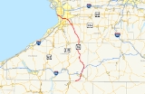
New York State Route 16 (NY 16) is a state highway
in western New York
, United States
. It runs from the Pennsylvania state line
, where it is one of the highest highways in the state in elevation, to downtown Buffalo
. NY 16 is a major route through Erie County
, despite the construction of the paralleling NY 400
expressway from East Aurora
. In Cattaraugus County
it also plays an important role, serving as the major connection from Olean
to the Southern Tier Expressway (Interstate 86
or I-86 and NY 17
). Between those two areas, and indeed for much of its length, it is a two-lane rural road.
NY 16 initially ended in Olean when it was assigned in 1924. It was extended south to the Pennsylvania state line in the early 1930s; however, it initially overlapped NY 17 east to Portville
, where it connected to Pennsylvania by way of modern NY 305
. NY 16's current alignment south of Olean was originally designated as New York State Route 16A around this time. NY 16 was rerouted to follow the routing of NY 16A south of Olean in the early 1960s.
becomes NY 16 at the state line, it is already at a very high elevation on a ridgecrest, and at a rise two miles (3.2 km) into New York, it reaches 2386 feet (727.3 m) in elevation, making it the highest state highway in western New York
and among the highest in the state. It remains at a high elevation for several more miles, through what was once one of New York's major oil field
s. Afterwards, NY 16 then begins to drop through a narrow valley to cross the Allegheny River
and enter its first major community, the city of Olean (which, like several other communities in the region, takes its name from oil
). It crosses the city as Union Street, intersecting its first state highway, NY 417
, at State Street. Here, ownership and maintenance of NY 16 shifts to the city for six blocks before becoming state-maintained once more at the point where North Union Street heads northwest to serve North Olean.
 A mile (1.6 km) north of NY 417, NY 16 reaches a bridge over Olean Creek, a tributary
of the Allegheny. On the other side, it becomes a four-lane road with a divider as it approaches NY 17
, currently concurrent with I-86
pending the entire expressway's upgrade to Interstate Highway standards
. A trumpet interchange
provides access to NY 17 and I-86 in both directions in the vicinity of Baldwin Heights. But NY 16 runs parallel to the freeway and remains a four-lane route, although no longer divided, following the Olean valley. At Hinsdale
it finally does cross NY 17. Shortly afterwards, in the hamlet
of Maplehurst, NY 446
, the former route of NY 408
, comes in from the east and terminates.
NY 16 now follows the narrow valley of Ischua Creek, one of the Olean's tributaries, north past the road to the city's airport, north to Franklinville
. NY 98
joins NY 16 just south of the village and leaves north of it. NY 16 continues to Machias
and the eastern end of NY 242
. A straight course takes the highway from this junction to the Cattaraugus Creek
bridge. This bridge heads into Erie County
.
. NY 16 then begins heading slightly northwestward through a wider, more developed valley in the towns of Holland and Wales
to the first sign of an approaching major metropolitan area
, the south end of NY 400
, the Aurora Expressway. After joining the expressway for two miles (3 km), it again leaves to become a two-lane that enters East Aurora
as Olean Street. At the intersection with Main Street, NY 16 turns left and briefly joins with U.S. Route 20A
(US 20A) and NY 78
. US 20A leaves the two state routes behind at a fork at the village's east end, leaving NY 16 and NY 78 to head to the northwest again as Buffalo Street. At this point, NY 16 and NY 78 become county-maintained for the next 6.5 miles (10.5 km) as the unsigned County Route 572 (CR 572). At Willardshire Road as the highway passes the industrial park
s and other facilities associated with local company Moog Inc
. North of the village, it enters the Town of Elma
and becomes Seneca Street, the name it will retain all the way to the city.
NY 78 takes on its best-known name as well when it leaves at Transit Road (US 20
), as NY 16 assumes an east–west heading across the suburban neighborhoods of West Seneca. It crosses NY 277
, a major retail strip, at Union Road in the hamlet of Ebenezer. One final trumpet exit to NY 400 (and by extension, the New York State Thruway
) precedes its junction with Harlem Road (NY 240
), where county maintenance of NY 16, and thus the overlap with CR 572, ends. Just west of NY 240, NY 16 crosses the Thruway itself as it begins to head to the northwest and enter the city of Buffalo
, where the route is locally maintained. Running almost due northwest through the residential neighborhoods of South Buffalo, NY 16 reaches its last major junction, with US 62
, at Bailey Avenue just after crossing the Buffalo River
. Immediately afterwards it crosses I-190
with no exit (but with northbound access) and returns to a more east–west course through industrial areas before ending at Main Street, NY 5
, in the city center.
 The portion of modern NY 16 between Hinsdale
and Buffalo
was originally designated as Route 17, an unsigned legislative route
, by the New York State Legislature in 1908. At the same time, the segment of what is now NY 16 from Olean to Hinsdale was included in Route 4, a lengthy east–west route that extended from Lake Erie
in Chautauqua County
to the Hudson River
in Orange County
. When the first set of posted routes in New York were assigned in 1924, much of Route 4—including the Olean–Hinsdale segment—was designated as NY 17
while legislative Route 17 became part of NY 16, which began in Olean and overlapped with NY 17 along former legislative Route 4 between Olean and Hinsdale.
In the 1930 renumbering of state highways in New York, NY 17 was realigned between Olean and Wellsville
to follow modern NY 417
, eliminating its overlap with NY 16. By the following year, NY 16 was extended south to the Pennsylvania state line near Portville
via NY 17 and what is now NY 305
. Ca. 1932, the modern routing of NY 16 between Pennsylvania and Olean was designated as NY 16A. The alignments of both NY 16 and NY 16A remained the same until ca. 1963 when NY 16A was supplanted by a rerouted NY 16. The former routing of NY 16 between the Pennsylvania state line and NY 17 became an extension of NY 305.
The portion of the Aurora Expressway (NY 400
) between East Aurora
and South Wales was completed in the early 1970s. NY 16 was rerouted to follow the new highway for two miles (3 km) before exiting the freeway and returning to its previous alignment. The former routing of NY 16 in the area, a 2.24 miles (3.6 km) long portion of Olean Road, is now NY 951V, an unsigned reference route.
State highway
State highway, state road or state route can refer to one of three related concepts, two of them related to a state or provincial government in a country that is divided into states or provinces :#A...
in western New York
Western New York
Western New York is the westernmost region of the state of New York. It includes the cities of Buffalo, Rochester, Niagara Falls, the surrounding suburbs, as well as the outlying rural areas of the Great Lakes lowlands, the Genesee Valley, and the Southern Tier. Some historians, scholars and others...
, United States
United States
The United States of America is a federal constitutional republic comprising fifty states and a federal district...
. It runs from the Pennsylvania state line
New York - Pennsylvania Border
The New York–Pennsylvania border is the state line between the U.S. states of New York and Pennsylvania. It has three sections:* along the center line of the Delaware River from the tri-point with New Jersey at the confluence of the Delaware with the Neversink River in Port Jervis, New York to the...
, where it is one of the highest highways in the state in elevation, to downtown Buffalo
Buffalo, New York
Buffalo is the second most populous city in the state of New York, after New York City. Located in Western New York on the eastern shores of Lake Erie and at the head of the Niagara River across from Fort Erie, Ontario, Buffalo is the seat of Erie County and the principal city of the...
. NY 16 is a major route through Erie County
Erie County, New York
Erie County is a county located in the U.S. state of New York. As of the 2010 census, the population was 919,040. The county seat is Buffalo. The county's name comes from Lake Erie, which in turn comes from the Erie tribe of American Indians who lived south and east of the lake before 1654.Erie...
, despite the construction of the paralleling NY 400
New York State Route 400
New York State Route 400 is a state highway located within Erie County, New York, in the United States. The northwest end is connected to the New York State Thruway and the southeast end terminates at NY 16 in the town of Aurora. NY 400, a limited-access highway, roughly parallels...
expressway from East Aurora
East Aurora, New York
East Aurora is a village in Erie County, New York, United States, southeast of Buffalo. The Village of East Aurora lies in the eastern half of the Town of Aurora.The population was 6,673 at the 2000 census...
. In Cattaraugus County
Cattaraugus County, New York
Cattaraugus County is a county located in the U.S. state of New York. As of the 2010 census, the population was 80,317. The county seat is Little Valley.-History:...
it also plays an important role, serving as the major connection from Olean
Olean, New York
Olean is a city in Cattaraugus County, New York, United States. Olean is the largest city in Cattaraugus County, and serves as the financial, business, transportation and entertainment center of the county. It is one of the principal cities of the Southern Tier region of New York.The city is...
to the Southern Tier Expressway (Interstate 86
Interstate 86 (east)
Interstate 86 is an Interstate Highway that extends for through northwestern Pennsylvania and southern New York in the United States...
or I-86 and NY 17
New York State Route 17
New York State Route 17 is a state highway that extends for through the Southern Tier and Downstate regions of New York in the United States...
). Between those two areas, and indeed for much of its length, it is a two-lane rural road.
NY 16 initially ended in Olean when it was assigned in 1924. It was extended south to the Pennsylvania state line in the early 1930s; however, it initially overlapped NY 17 east to Portville
Portville (village), New York
Portville is a village in Cattaraugus County, New York, USA. The population was 1,024 at the 2000 census. The Village of Portville is within the south part of the Town of Portville and southeast of Olean, New York.- History :...
, where it connected to Pennsylvania by way of modern NY 305
New York State Route 305
New York State Route 305 is a north–south route in the Southern Tier that runs from the Pennsylvania state line in Cattaraugus County to the hamlet of Belfast in Allegany County, where it ends at NY 19...
. NY 16's current alignment south of Olean was originally designated as New York State Route 16A around this time. NY 16 was rerouted to follow the routing of NY 16A south of Olean in the early 1960s.
Cattaraugus County
When PA 646Pennsylvania Route 646
Pennsylvania Route 646 is a long state highway located in McKean county in Pennsylvania. The southern terminus is at PA 59 in Keating Township. The northern terminus is the New York state line in Foster Township...
becomes NY 16 at the state line, it is already at a very high elevation on a ridgecrest, and at a rise two miles (3.2 km) into New York, it reaches 2386 feet (727.3 m) in elevation, making it the highest state highway in western New York
Western New York
Western New York is the westernmost region of the state of New York. It includes the cities of Buffalo, Rochester, Niagara Falls, the surrounding suburbs, as well as the outlying rural areas of the Great Lakes lowlands, the Genesee Valley, and the Southern Tier. Some historians, scholars and others...
and among the highest in the state. It remains at a high elevation for several more miles, through what was once one of New York's major oil field
Oil field
An oil field is a region with an abundance of oil wells extracting petroleum from below ground. Because the oil reservoirs typically extend over a large area, possibly several hundred kilometres across, full exploitation entails multiple wells scattered across the area...
s. Afterwards, NY 16 then begins to drop through a narrow valley to cross the Allegheny River
Allegheny River
The Allegheny River is a principal tributary of the Ohio River; it is located in the Eastern United States. The Allegheny River joins with the Monongahela River to form the Ohio River at the "Point" of Point State Park in Downtown Pittsburgh, Pennsylvania...
and enter its first major community, the city of Olean (which, like several other communities in the region, takes its name from oil
Petroleum
Petroleum or crude oil is a naturally occurring, flammable liquid consisting of a complex mixture of hydrocarbons of various molecular weights and other liquid organic compounds, that are found in geologic formations beneath the Earth's surface. Petroleum is recovered mostly through oil drilling...
). It crosses the city as Union Street, intersecting its first state highway, NY 417
New York State Route 417
New York State Route 417 is an east–west state highway located in the Southern Tier of New York in the United States. It begins at exit 20 of the Southern Tier Expressway in the city of Salamanca and ends at a junction with NY 415 in Painted Post, west of the city of Corning...
, at State Street. Here, ownership and maintenance of NY 16 shifts to the city for six blocks before becoming state-maintained once more at the point where North Union Street heads northwest to serve North Olean.
Tributary
A tributary or affluent is a stream or river that flows into a main stem river or a lake. A tributary does not flow directly into a sea or ocean...
of the Allegheny. On the other side, it becomes a four-lane road with a divider as it approaches NY 17
New York State Route 17
New York State Route 17 is a state highway that extends for through the Southern Tier and Downstate regions of New York in the United States...
, currently concurrent with I-86
Interstate 86 (east)
Interstate 86 is an Interstate Highway that extends for through northwestern Pennsylvania and southern New York in the United States...
pending the entire expressway's upgrade to Interstate Highway standards
Interstate Highway standards
Standards for Interstate Highways in the United States are defined by the American Association of State Highway and Transportation Officials in the publication A Policy on Design Standards - Interstate System...
. A trumpet interchange
Interchange (road)
In the field of road transport, an interchange is a road junction that typically uses grade separation, and one or more ramps, to permit traffic on at least one highway to pass through the junction without directly crossing any other traffic stream. It differs from a standard intersection, at which...
provides access to NY 17 and I-86 in both directions in the vicinity of Baldwin Heights. But NY 16 runs parallel to the freeway and remains a four-lane route, although no longer divided, following the Olean valley. At Hinsdale
Hinsdale, New York
Hinsdale is a town in Cattaraugus County, New York, United States. The population was 2,270 at the 2000 census. The town was named after another location: Hinsdale, New Hampshire....
it finally does cross NY 17. Shortly afterwards, in the hamlet
Hamlet (place)
A hamlet is usually a rural settlement which is too small to be considered a village, though sometimes the word is used for a different sort of community. Historically, when a hamlet became large enough to justify building a church, it was then classified as a village...
of Maplehurst, NY 446
New York State Route 446
New York State Route 446 is a state highway in the Southern Tier of New York in the United States. It parallels the Southern Tier Expressway very closely between Hinsdale and Cuba. The western terminus of the route is at an intersection with NY 16 north of the hamlet of Hinsdale...
, the former route of NY 408
New York State Route 408
New York State Route 408 is a state highway located entirely within Livingston County, New York, in the United States. It runs north–south from an intersection with NY 70 near the hamlet of Dalton in the town of Nunda to a junction with NY 63 in the town of Groveland near...
, comes in from the east and terminates.
NY 16 now follows the narrow valley of Ischua Creek, one of the Olean's tributaries, north past the road to the city's airport, north to Franklinville
Franklinville (village), New York
Franklinville is a village in Cattaraugus County, New York, USA. The population was 1,855 at the 2000 census. The community was named after Benjamin Franklin.The Village of Franklinville is in the northeast part of the Town of Franklinville....
. NY 98
New York State Route 98
New York State Route 98 is a state highway in the western part of New York in the United States. The southern terminus of the route is at an intersection with U.S. Route 219 in the town of Great Valley in Cattaraugus County...
joins NY 16 just south of the village and leaves north of it. NY 16 continues to Machias
Machias, New York
Machias is a town in Cattaraugus County, New York, United States. The population was 2,482 at the 2000 census.The Town of Machias is an interior town in the northeast quadrant of the county. It is northeast of the city of Salamanca.-History:...
and the eastern end of NY 242
New York State Route 242
New York State Route 242 is a state highway that runs across Cattaraugus County, New York, in the United States. Although signed as an east–west route, it takes a more northeast–southwest course across the county from NY 394 near the village of Randolph to NY 16 in Machias...
. A straight course takes the highway from this junction to the Cattaraugus Creek
Cattaraugus Creek
Cattaraugus Creek is a stream, approximately 68 miles long, in western New York in the United States. The creek drains a wooded rural portion of western New York southwest of Buffalo into Lake Erie. In its lower course it flows primarily through the Cattaraugus Reservation of the Seneca tribe...
bridge. This bridge heads into Erie County
Erie County, New York
Erie County is a county located in the U.S. state of New York. As of the 2010 census, the population was 919,040. The county seat is Buffalo. The county's name comes from Lake Erie, which in turn comes from the Erie tribe of American Indians who lived south and east of the lake before 1654.Erie...
.
Erie County
In the southwestern corner of the county, NY 16 intersects with NY 39New York State Route 39
New York State Route 39 is an east–west state highway in the western portion of New York in the United States. It begins and ends at intersections with U.S. Route 20 apart...
. NY 16 then begins heading slightly northwestward through a wider, more developed valley in the towns of Holland and Wales
Wales, New York
Wales is a town in Erie County, New York, United States. The town is one of the "Southtowns" of Erie County by virtue of its position in the southeast part of the county, southeast of Buffalo.-History of Wales :...
to the first sign of an approaching major metropolitan area
Metropolitan area
The term metropolitan area refers to a region consisting of a densely populated urban core and its less-populated surrounding territories, sharing industry, infrastructure, and housing. A metropolitan area usually encompasses multiple jurisdictions and municipalities: neighborhoods, townships,...
, the south end of NY 400
New York State Route 400
New York State Route 400 is a state highway located within Erie County, New York, in the United States. The northwest end is connected to the New York State Thruway and the southeast end terminates at NY 16 in the town of Aurora. NY 400, a limited-access highway, roughly parallels...
, the Aurora Expressway. After joining the expressway for two miles (3 km), it again leaves to become a two-lane that enters East Aurora
East Aurora, New York
East Aurora is a village in Erie County, New York, United States, southeast of Buffalo. The Village of East Aurora lies in the eastern half of the Town of Aurora.The population was 6,673 at the 2000 census...
as Olean Street. At the intersection with Main Street, NY 16 turns left and briefly joins with U.S. Route 20A
U.S. Route 20A (New York)
U.S. Route 20A is an east–west alternate route of US 20 that extends for across the western portion of New York in the United States. It leaves US 20 in Hamburg, a suburb of Buffalo, and rejoins it in East Bloomfield about five miles west of Canandaigua, the county seat of...
(US 20A) and NY 78
New York State Route 78
New York State Route 78 , most commonly known as Transit Road, is a state highway in Western New York, USA. While it is signed north–south, the lower portion runs in an east–west direction across Wyoming County, from its beginning north of the Village of Gainesville.NY 78 is...
. US 20A leaves the two state routes behind at a fork at the village's east end, leaving NY 16 and NY 78 to head to the northwest again as Buffalo Street. At this point, NY 16 and NY 78 become county-maintained for the next 6.5 miles (10.5 km) as the unsigned County Route 572 (CR 572). At Willardshire Road as the highway passes the industrial park
Industrial park
An industrial park is an area zoned and planned for the purpose of industrial development...
s and other facilities associated with local company Moog Inc
Moog Inc
Moog is a worldwide designer and manufacturer of motion and fluid controls and control systems for applications in aerospace, defense, industrial and medical device markets...
. North of the village, it enters the Town of Elma
Elma, New York
Elma is a town in Erie County, New York, United States. The population was 11,304 at the 2000 census. The town is named after a type of tree.The Town of Elma is located in the north-central part of the county, east of Buffalo, New York. Because of its location, Elma likes to refer to itself as the...
and becomes Seneca Street, the name it will retain all the way to the city.
NY 78 takes on its best-known name as well when it leaves at Transit Road (US 20
U.S. Route 20
U.S. Route 20 is an east–west United States highway. As the "0" in its route number implies, US 20 is a coast-to-coast route. Spanning , it is the longest road in the United States, and the route sparsely parallels Interstate 90...
), as NY 16 assumes an east–west heading across the suburban neighborhoods of West Seneca. It crosses NY 277
New York State Route 277
New York State Route 277 is a state highway in New York, USA. This highway is also called Union Road, along with other names. NY 277 is a major north–south road east of Buffalo, New York, through the middle of Erie County...
, a major retail strip, at Union Road in the hamlet of Ebenezer. One final trumpet exit to NY 400 (and by extension, the New York State Thruway
New York State Thruway
The New York State Thruway is a system of limited-access highways located within the state of New York in the United States. The system, known officially as the Governor Thomas E. Dewey Thruway for former New York Governor Thomas E. Dewey, is operated by the New York State Thruway Authority and...
) precedes its junction with Harlem Road (NY 240
New York State Route 240
New York State Route 240 is a state highway in western New York in the United States. The southern terminus of the route is at an intersection with NY 242 in the Ellicottville community of Ashford in northern Cattaraugus County. Its northern terminus is at a junction with NY 324...
), where county maintenance of NY 16, and thus the overlap with CR 572, ends. Just west of NY 240, NY 16 crosses the Thruway itself as it begins to head to the northwest and enter the city of Buffalo
Buffalo, New York
Buffalo is the second most populous city in the state of New York, after New York City. Located in Western New York on the eastern shores of Lake Erie and at the head of the Niagara River across from Fort Erie, Ontario, Buffalo is the seat of Erie County and the principal city of the...
, where the route is locally maintained. Running almost due northwest through the residential neighborhoods of South Buffalo, NY 16 reaches its last major junction, with US 62
U.S. Route 62
U.S. Route 62 runs from the US-Mexico border at El Paso, Texas to Niagara Falls, New York, near the United States-Canada border. It is the only east-west US Route that connects Mexico and Canada.Parts of U.S...
, at Bailey Avenue just after crossing the Buffalo River
Buffalo River (New York)
The Buffalo River is a river that empties into the eastern end of Lake Erie, one of the Great Lakes, by the City of Buffalo in the United States of America. This stream is called the Buffalo River only in the vicinity of the city and is known as Buffalo Creek as it flows through other parts of...
. Immediately afterwards it crosses I-190
Interstate 190 (New York)
Interstate 190 runs 28.34 miles from Interstate 90 near Buffalo, New York to Lewiston, New York via Niagara Falls. Parts of this highway were built on the former rights-of-way of the Lehigh Valley Railroad and the Erie Canal. It is referred to by locals as The One-Ninety...
with no exit (but with northbound access) and returns to a more east–west course through industrial areas before ending at Main Street, NY 5
New York State Route 5
New York State Route 5 is a state highway that extends for across the state of New York in the United States. It begins at the Pennsylvania state line in the Chautauqua County town of Ripley and passes through Buffalo, Syracuse, Utica, Schenectady, and several other smaller cities and...
, in the city center.
History
Hinsdale, New York
Hinsdale is a town in Cattaraugus County, New York, United States. The population was 2,270 at the 2000 census. The town was named after another location: Hinsdale, New Hampshire....
and Buffalo
Buffalo, New York
Buffalo is the second most populous city in the state of New York, after New York City. Located in Western New York on the eastern shores of Lake Erie and at the head of the Niagara River across from Fort Erie, Ontario, Buffalo is the seat of Erie County and the principal city of the...
was originally designated as Route 17, an unsigned legislative route
Legislative route
In United States, a legislative route or legislative highway is a highway defined by laws passed in a state legislature. The numbering of such highways may or may not correspond to the numbers familiar to the public as part of the state, U.S. highway, and Interstate highway systems...
, by the New York State Legislature in 1908. At the same time, the segment of what is now NY 16 from Olean to Hinsdale was included in Route 4, a lengthy east–west route that extended from Lake Erie
Lake Erie
Lake Erie is the fourth largest lake of the five Great Lakes in North America, and the tenth largest globally. It is the southernmost, shallowest, and smallest by volume of the Great Lakes and therefore also has the shortest average water residence time. It is bounded on the north by the...
in Chautauqua County
Chautauqua County, New York
-Major highways:* Interstate 86/New York State Route 17 * Interstate 90 * U.S. Route 20* U.S. Route 62* New York State Route 5* New York State Route 39* New York State Route 60* New York State Route 394...
to the Hudson River
Hudson River
The Hudson is a river that flows from north to south through eastern New York. The highest official source is at Lake Tear of the Clouds, on the slopes of Mount Marcy in the Adirondack Mountains. The river itself officially begins in Henderson Lake in Newcomb, New York...
in Orange County
Orange County, New York
Orange County is a county located in the U.S. state of New York. It is part of the Poughkeepsie–Newburgh–Middletown, NY Metropolitan Statistical Area and is located at the northern reaches of the New York metropolitan area. The county sits in the state's scenic Mid-Hudson Region of the Hudson Valley...
. When the first set of posted routes in New York were assigned in 1924, much of Route 4—including the Olean–Hinsdale segment—was designated as NY 17
New York State Route 17
New York State Route 17 is a state highway that extends for through the Southern Tier and Downstate regions of New York in the United States...
while legislative Route 17 became part of NY 16, which began in Olean and overlapped with NY 17 along former legislative Route 4 between Olean and Hinsdale.
In the 1930 renumbering of state highways in New York, NY 17 was realigned between Olean and Wellsville
Wellsville (village), New York
Wellsville is a Village in Allegany County of New York State. At the top of the Eastern Triple Continental Divide, in south-central wooded and rural Allegany County, it is the largest population and business center in a 30-mile radius. The population was 5,171 at the 2000 census...
to follow modern NY 417
New York State Route 417
New York State Route 417 is an east–west state highway located in the Southern Tier of New York in the United States. It begins at exit 20 of the Southern Tier Expressway in the city of Salamanca and ends at a junction with NY 415 in Painted Post, west of the city of Corning...
, eliminating its overlap with NY 16. By the following year, NY 16 was extended south to the Pennsylvania state line near Portville
Portville (village), New York
Portville is a village in Cattaraugus County, New York, USA. The population was 1,024 at the 2000 census. The Village of Portville is within the south part of the Town of Portville and southeast of Olean, New York.- History :...
via NY 17 and what is now NY 305
New York State Route 305
New York State Route 305 is a north–south route in the Southern Tier that runs from the Pennsylvania state line in Cattaraugus County to the hamlet of Belfast in Allegany County, where it ends at NY 19...
. Ca. 1932, the modern routing of NY 16 between Pennsylvania and Olean was designated as NY 16A. The alignments of both NY 16 and NY 16A remained the same until ca. 1963 when NY 16A was supplanted by a rerouted NY 16. The former routing of NY 16 between the Pennsylvania state line and NY 17 became an extension of NY 305.
The portion of the Aurora Expressway (NY 400
New York State Route 400
New York State Route 400 is a state highway located within Erie County, New York, in the United States. The northwest end is connected to the New York State Thruway and the southeast end terminates at NY 16 in the town of Aurora. NY 400, a limited-access highway, roughly parallels...
) between East Aurora
East Aurora, New York
East Aurora is a village in Erie County, New York, United States, southeast of Buffalo. The Village of East Aurora lies in the eastern half of the Town of Aurora.The population was 6,673 at the 2000 census...
and South Wales was completed in the early 1970s. NY 16 was rerouted to follow the new highway for two miles (3 km) before exiting the freeway and returning to its previous alignment. The former routing of NY 16 in the area, a 2.24 miles (3.6 km) long portion of Olean Road, is now NY 951V, an unsigned reference route.