
New York State Route 263
Encyclopedia
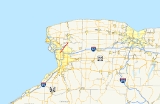
New York State Route 263 (NY 263) is a state highway
located entirely within the town of Amherst
in Erie County, New York
, in the United States. It extends from just north of the northeast corner of the city of Buffalo
in a roughly northeast direction almost straight to just south of the north county line. The road is named Millersport Highway north of Eggert Road in Amherst for the community
at its northern terminus. The section between its southern terminus at U.S. Route 62
(US 62) and the Eggert Road intersection is named Grover Cleveland Highway.
While the construction of Interstate 990 (I-990) has diminished NY 263's importance as the major route for traffic from Buffalo to Lockport
, traffic must continue on NY 263 past the northern terminus of I-990 to complete the trip to Lockport.
Its southern portion is also one of Amherst's many commercial strips.
), a short distance north of the Buffalo
city line in Amherst
. Like US 62, NY 263 in this area is a busy shopping strip for Eggertsville, the surrounding suburban neighborhood. This section is called the Grover Cleveland Highway after former Buffalo mayor, New York governor and US President Grover Cleveland
. It soon crosses two of the northern Buffalo area's important arteries, Sheridan Drive (NY 324
) and the Youngmann Expressway (I-290
).
The stores that have been almost continuously lining the road abate shortly after the interstate when it makes its only deviation from its straight course, curving around the north campus of SUNY Buffalo
, where it was relocated in the early 1970s. Past the campus and a nearby office park, the road narrows to two lanes in the small suburban hamlet of Getzville
, where NY 270
heads due north as Campbell Boulevard.
North of Getzville the road continues straight through the much less developed, and more wooded, lands of East Amherst. After several miles, I-990
reaches its current end when both roadways terminate at the west side of the highway. NY 263's reaches its northern terminus at Transit Road (NY 78
) approximately a half mile below the county line of Niagara County
in an area called Millersport
, which straddles the county line and gives the entire highway its name.
was designated as part of NY 270
. NY 263 was assigned by the following year; however, it initially followed a significantly different alignment than it does today. At the time, the route extended from NY 270 south of Getzville to NY 93
northwest of Akron
by way of Millersport
. West of Millersport, NY 263 utilized a short portion of its current alignment before taking a more northerly path along Hopkins Road and Tonawanda Creek Road. At Millersport, the route overlapped with NY 78
south to Wolcott Road, from where it continued northeast through Clarence
on Wolcott and Goodrich Roads.
At the north end of Goodrich Road, located on the southern bank of Tonawanda Creek
, NY 263 curved to the east, following Tonawanda Creek Road once again to Salt Road. Here, NY 263 veered southward, continuing on Salt Road to Hunts Corners – Akron Road. At this junction, it turned one final time to follow Hunts Corners – Akron Road east to NY 93 near Akron. NY 263 was realigned ca. 1934 to use Tonawanda Creek Road between NY 78 and Goodrich Road. It was altered again by the following year to continue south along Salt Road from Hunts Corners – Akron Road to NY 5
in the hamlet of Clarence. Around the same time, NY 263 was realigned onto a newly-constructed extension of Millersport Highway between Hopkins Road and Millerport.
NY 263 was realigned ca. 1938 to overlap with NY 78 north to NY 31
in Lockport
. Its former alignment east of NY 78 became a realignment of NY 268. In the early 1940s, NY 263 was extended southwest to Buffalo over NY 270. Initially, NY 263 overlapped with NY 270 along Millersport Highway; however, the overlap was eliminated in the late 1940s after NY 270 was truncated to begin at NY 263 in Getzville. NY 263 was cut back to its current northern terminus in Millersport ca. 1962. The route was re-extended to Clarence ca. 1974, replacing NY 268; however, the extension was short-lived as NY 263 was pulled back to its junction with NY 78 by 1977.
State highway
State highway, state road or state route can refer to one of three related concepts, two of them related to a state or provincial government in a country that is divided into states or provinces :#A...
located entirely within the town of Amherst
Amherst, New York
Amherst is a town in Erie County, New York, United States. As of the 2010 census, the town had a total population of 122,366. This represents an increase of 5.0% from the 2000 census. The town is named for Jeffrey Amherst, a British Army officer of the colonial period...
in Erie County, New York
Erie County, New York
Erie County is a county located in the U.S. state of New York. As of the 2010 census, the population was 919,040. The county seat is Buffalo. The county's name comes from Lake Erie, which in turn comes from the Erie tribe of American Indians who lived south and east of the lake before 1654.Erie...
, in the United States. It extends from just north of the northeast corner of the city of Buffalo
Buffalo, New York
Buffalo is the second most populous city in the state of New York, after New York City. Located in Western New York on the eastern shores of Lake Erie and at the head of the Niagara River across from Fort Erie, Ontario, Buffalo is the seat of Erie County and the principal city of the...
in a roughly northeast direction almost straight to just south of the north county line. The road is named Millersport Highway north of Eggert Road in Amherst for the community
Millersport, New York
Millersport, New York is an unincorporated hamlet in the town of Clarence in Erie County, New York, USA. It is the namesake of the Millersport Highway, known legally as New York State Route 263.-References:...
at its northern terminus. The section between its southern terminus at U.S. Route 62
U.S. Route 62 in New York
U.S. Route 62 is a part of the U.S. Highway System that runs from the United States – Mexico border at El Paso, Texas, to Niagara Falls, New York. In the U.S. state of New York, US 62 extends from the New York – Pennsylvania border south of Jamestown to an intersection with...
(US 62) and the Eggert Road intersection is named Grover Cleveland Highway.
While the construction of Interstate 990 (I-990) has diminished NY 263's importance as the major route for traffic from Buffalo to Lockport
Lockport (city), New York
Lockport is a city in Niagara County, New York, United States. The population was 21,165 at the 2010 census. The name is derived from a set of Erie canal locks within the city. Lockport is the county seat of Niagara County and is surrounded by the town of Lockport...
, traffic must continue on NY 263 past the northern terminus of I-990 to complete the trip to Lockport.
Its southern portion is also one of Amherst's many commercial strips.
Route description
The south end of NY 263 is at Bailey Avenue (US 62U.S. Route 62 in New York
U.S. Route 62 is a part of the U.S. Highway System that runs from the United States – Mexico border at El Paso, Texas, to Niagara Falls, New York. In the U.S. state of New York, US 62 extends from the New York – Pennsylvania border south of Jamestown to an intersection with...
), a short distance north of the Buffalo
Buffalo, New York
Buffalo is the second most populous city in the state of New York, after New York City. Located in Western New York on the eastern shores of Lake Erie and at the head of the Niagara River across from Fort Erie, Ontario, Buffalo is the seat of Erie County and the principal city of the...
city line in Amherst
Amherst, New York
Amherst is a town in Erie County, New York, United States. As of the 2010 census, the town had a total population of 122,366. This represents an increase of 5.0% from the 2000 census. The town is named for Jeffrey Amherst, a British Army officer of the colonial period...
. Like US 62, NY 263 in this area is a busy shopping strip for Eggertsville, the surrounding suburban neighborhood. This section is called the Grover Cleveland Highway after former Buffalo mayor, New York governor and US President Grover Cleveland
Grover Cleveland
Stephen Grover Cleveland was the 22nd and 24th president of the United States. Cleveland is the only president to serve two non-consecutive terms and therefore is the only individual to be counted twice in the numbering of the presidents...
. It soon crosses two of the northern Buffalo area's important arteries, Sheridan Drive (NY 324
New York State Route 324
New York State Route 324 is an east–west state highway located in the western portion of New York in the United States...
) and the Youngmann Expressway (I-290
Interstate 290 (New York)
Interstate 290 runs for near Buffalo, New York from I-90 to I-190. It connects Buffalo with its northern suburbs of Amherst and Tonawanda, and provides a route to Niagara Falls that bypasses the city of Buffalo. I-290 also connects to Interstate 990, and through this connection,...
).
The stores that have been almost continuously lining the road abate shortly after the interstate when it makes its only deviation from its straight course, curving around the north campus of SUNY Buffalo
University at Buffalo, The State University of New York
University at Buffalo, The State University of New York, also commonly known as the University at Buffalo or UB, is a public research university and a "University Center" in the State University of New York system. The university was founded by Millard Fillmore in 1846. UB has multiple campuses...
, where it was relocated in the early 1970s. Past the campus and a nearby office park, the road narrows to two lanes in the small suburban hamlet of Getzville
Getzville, New York
Getzville, New York is an unincorporated hamlet in the Town of Amherst in Erie County, New York, USA.Getzville's zip code is 14068, and has a post office located on Millersport Highway -Geography :...
, where NY 270
New York State Route 270
New York State Route 270 is a north–south state highway in western New York in the United States. It runs through rural and wooded areas of the town of Amherst in Erie County and the town of Pendleton in Niagara County. The southern terminus of the route is at an intersection with NY 263...
heads due north as Campbell Boulevard.
North of Getzville the road continues straight through the much less developed, and more wooded, lands of East Amherst. After several miles, I-990
Interstate 990
Interstate 990 is an auxiliary Interstate Highway located entirely within the town of Amherst in Erie County, New York, in the United States. It runs in a roughly north–south direction for through the southwestern and central parts of Amherst from Interstate 290 north of Buffalo to...
reaches its current end when both roadways terminate at the west side of the highway. NY 263's reaches its northern terminus at Transit Road (NY 78
New York State Route 78
New York State Route 78 , most commonly known as Transit Road, is a state highway in Western New York, USA. While it is signed north–south, the lower portion runs in an east–west direction across Wyoming County, from its beginning north of the Village of Gainesville.NY 78 is...
) approximately a half mile below the county line of Niagara County
Niagara County, New York
Niagara County is a county located in the U.S. state of New York. As of the 2010 census, the population was 216,469. The county seat is Lockport. The county name is from the Iroquois word Onguiaahra; meaning the strait or thunder of waters. It is the location of Niagara Falls and Fort Niagara, and...
in an area called Millersport
Millersport, New York
Millersport, New York is an unincorporated hamlet in the town of Clarence in Erie County, New York, USA. It is the namesake of the Millersport Highway, known legally as New York State Route 263.-References:...
, which straddles the county line and gives the entire highway its name.
History
In the 1930 renumbering of state highways in New York, the portion of what is now NY 263 south of GetzvilleGetzville, New York
Getzville, New York is an unincorporated hamlet in the Town of Amherst in Erie County, New York, USA.Getzville's zip code is 14068, and has a post office located on Millersport Highway -Geography :...
was designated as part of NY 270
New York State Route 270
New York State Route 270 is a north–south state highway in western New York in the United States. It runs through rural and wooded areas of the town of Amherst in Erie County and the town of Pendleton in Niagara County. The southern terminus of the route is at an intersection with NY 263...
. NY 263 was assigned by the following year; however, it initially followed a significantly different alignment than it does today. At the time, the route extended from NY 270 south of Getzville to NY 93
New York State Route 93
New York State Route 93 is a state highway in western New York in the United States. It runs in a northwest–southeast direction between NY 18F near the Niagara River in the village of Youngstown and NY 5 just south of the village of Akron...
northwest of Akron
Akron, New York
Akron, New York is a village in Erie County, New York, United States. The population was listed as 3,085 in the 2000 census. The name means a high place. It is part of the Buffalo–Niagara Falls Metropolitan Statistical Area....
by way of Millersport
Millersport, New York
Millersport, New York is an unincorporated hamlet in the town of Clarence in Erie County, New York, USA. It is the namesake of the Millersport Highway, known legally as New York State Route 263.-References:...
. West of Millersport, NY 263 utilized a short portion of its current alignment before taking a more northerly path along Hopkins Road and Tonawanda Creek Road. At Millersport, the route overlapped with NY 78
New York State Route 78
New York State Route 78 , most commonly known as Transit Road, is a state highway in Western New York, USA. While it is signed north–south, the lower portion runs in an east–west direction across Wyoming County, from its beginning north of the Village of Gainesville.NY 78 is...
south to Wolcott Road, from where it continued northeast through Clarence
Clarence, New York
Clarence is a town located in the northeastern part of Erie County, New York, United States. The population was 30,673 according to the 2010 census. This represents an increase of 17.42% from the 2000 census figure . Clarence is also the name of a postal district in the south part of the town...
on Wolcott and Goodrich Roads.
At the north end of Goodrich Road, located on the southern bank of Tonawanda Creek
Tonawanda Creek
Tonawanda Creek is a small river in Western New York, in the United States. William Bright says the best that can be said of the name is that it is "probably from an Iroquoian source, but of unclear derivation".-Description:...
, NY 263 curved to the east, following Tonawanda Creek Road once again to Salt Road. Here, NY 263 veered southward, continuing on Salt Road to Hunts Corners – Akron Road. At this junction, it turned one final time to follow Hunts Corners – Akron Road east to NY 93 near Akron. NY 263 was realigned ca. 1934 to use Tonawanda Creek Road between NY 78 and Goodrich Road. It was altered again by the following year to continue south along Salt Road from Hunts Corners – Akron Road to NY 5
New York State Route 5
New York State Route 5 is a state highway that extends for across the state of New York in the United States. It begins at the Pennsylvania state line in the Chautauqua County town of Ripley and passes through Buffalo, Syracuse, Utica, Schenectady, and several other smaller cities and...
in the hamlet of Clarence. Around the same time, NY 263 was realigned onto a newly-constructed extension of Millersport Highway between Hopkins Road and Millerport.
NY 263 was realigned ca. 1938 to overlap with NY 78 north to NY 31
New York State Route 31
New York State Route 31 is a state highway that extends for across western and central New York in the United States. The western terminus of the route is at an intersection with NY 104 in the city of Niagara Falls. Its eastern terminus is at a traffic circle with NY 26 in Vernon...
in Lockport
Lockport (city), New York
Lockport is a city in Niagara County, New York, United States. The population was 21,165 at the 2010 census. The name is derived from a set of Erie canal locks within the city. Lockport is the county seat of Niagara County and is surrounded by the town of Lockport...
. Its former alignment east of NY 78 became a realignment of NY 268. In the early 1940s, NY 263 was extended southwest to Buffalo over NY 270. Initially, NY 263 overlapped with NY 270 along Millersport Highway; however, the overlap was eliminated in the late 1940s after NY 270 was truncated to begin at NY 263 in Getzville. NY 263 was cut back to its current northern terminus in Millersport ca. 1962. The route was re-extended to Clarence ca. 1974, replacing NY 268; however, the extension was short-lived as NY 263 was pulled back to its junction with NY 78 by 1977.