
New York State Route 77
Encyclopedia
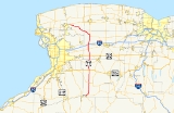
New York State Route 77 (NY 77) is a north–south state highway
in the western part
of New York
in the United States. The highway runs for 46.28 miles (74.48 km) across mostly rural areas from an intersection with NY 78
and NY 98
in the Wyoming County
town of Java
to a junction with NY 31
near the city of Lockport
in Niagara County
. It connects to several of the region's major east–west roads, including U.S. Route 20
(US 20) and the New York State Thruway
(Interstate 90
or I-90). In southwestern Genesee County
, the route takes on added importance as it provides the most direct route between the Thruway and Darien Lake, Western New York's largest amusement park
.
The route was assigned as part of the 1930 renumbering of state highways in New York to the portion of its modern routing north of US 20A
. Over the next 30 years, NY 77 was truncated and extended several times, moving the south end of the route to various locations in Wyoming and Genesee Counties. Throughout this time, NY 77 always extended at least as far south as Corfu
. It arrived at its current alignment ca. 1961.
and NY 98
in Java Center, a hamlet within the Wyoming County
town of Java
. Here, NY 78 heads east–west through the junction while NY 98 enters the intersection from the south and turns to follow NY 78 east toward an area known as Five Corners. NY 77, meanwhile, continues due north on the path set by NY 98 south of this point. The highway gradually descends through the open fields of Wyoming County, loosely paralleling the Arcade and Attica Railroad for 4 miles (6 km) to the railroad's end outside of North Java. Past this point, NY 77 heads into the town of Sheldon
, where it crosses US 20A
near the northern town line. In the adjacent town of Bennington
, the route serves the small hamlet of the same name, situated around NY 77's junction with NY 354
.
North of Bennington hamlet, the highway traverses some swampy areas on its way into Genesee County
, where it crosses the Norfolk Southern Railway
's Southern Tier Line
at a grade crossing just south of the Darien
hamlet of Darien Center. In the small community, located southeast of Darien Lakes State Park
, NY 77 intersects the cross-state US 20
. Not far to the north of Darien Center is Darien Lake, a sprawling amusement park located on the east side of the highway. The road, however, remains a two-lane highway as it continues north to the town of Pembroke
and the village of Corfu
, where it intersects NY 33
. NY 77 crosses another major east–west route, NY 5
, at a junction 2 miles (3.2 km) north of Corfu known locally as Brick House Corners.
Just beyond that junction, the truck stop
s and toll plaza associated with exit 48A of the New York State Thruway
(I-90
) come into view as the road dips slightly in elevation. After connecting to the Thruway's toll plaza, the highway makes its first major bend, turning northeast to pass under the Thruway. Past the Thruway, it once again continues in a more northerly fashion to the hamlet of Indian Falls
, a community located on the northern bank of the Tonawanda Creek
. NY 77 crosses the creek here, and the falls that give the hamlet its name are visible from the road. North of the falls, the surrounding land becomes mostly fields once again as the route resumes a due north alignment into the town of Alabama
. At the small hamlet of Basom, NY 77 intersects Bloomingdale Road, a local road serving the nearby Tonawanda Indian Reservation that was once part of NY 267
.
Not far from Basom, NY 63
comes in from the east and turns north onto NY 77, starting the only concurrency
along the latter route. This ends 1.5 miles (2.4 km) further north in the hamlet of Alabama
, where NY 77 turns to the west as NY 63 takes over the northbound route. The portion of NY 77 from NY 63 to the Niagara County
line is maintained by Genesee County as part of CR 12, which continues east of NY 63 along Lewiston, Lockport and North Byron Roads to CR 7 northeast of the village of Elba
. This section of NY 77 is the only part that is not maintained by the New York State Department of Transportation
(NYSDOT).
West of NY 63, NY 77 follows Lewiston Road northwest along the southwestern edge of Oak Orchard Swamp and the Iroquois National Wildlife Refuge
. As it heads into Niagara County, NY 77 continues to trend slightly northward, running along the northern fringe of the Tonawanda Wildlife Management Area
. About 6 miles (10 km) northwest of the county line is the hamlet of McNalls, which served as the southern terminus of the 1930s incarnation of NY 359. The route continues on to the eastern suburbs of the city of Lockport
, where NY 77 ends at an intersection with NY 31
near the community of Nottingham Estates.
east of Lockport
was originally designated as part of a spur of Route 30, an unsigned legislative route
, by the New York State Legislature in 1914. On March 1, 1921, the spur became part of an extended Route 20. When the first set of posted routes in New York were assigned in 1924, all of legislative Route 20 west of Rochester
was designated as part of NY 3
. In the 1930 renumbering of state highways in New York, NY 3 was realigned between Lockport and Gasport
to follow modern NY 31. Its former routing from Lockport to McNalls became part of NY 77, a new route assigned in the renumbering that began at US 20
(now US 20A
) in Sheldon
and passed through Corfu
, Alabama
, and McNalls on its way to NY 3 in Lockport.
NY 77 was extended south to Arcade
ca. 1933, following its modern alignment to Java Center and overlapping with NY 98
(via Chaffee and Curriers Roads, both part of NY 98 at the time) between Java Center and Arcade. The extension was short-lived, however, as NY 77 was truncated northward to NY 33
in Corfu ca. 1939. Around the same time, NY 98 was realigned to use East Arcade Road between Arcade and NY 78
in Java
. NY 77 was reextended southward to Java Center in the late 1950s and along modern NY 98 to the junction of Cattaraugus and East Arcade Roads (the latter then part of NY 98) near Arcade ca. 1961. NY 98 was realigned in the early 1960s to follow NY 77 between Arcade and Java Center, resulting in the truncation of NY 77 back to Java Center once again.
. It was assigned ca. 1935 and supplanted by an extended NY 267
in the late 1930s.
State highway
State highway, state road or state route can refer to one of three related concepts, two of them related to a state or provincial government in a country that is divided into states or provinces :#A...
in the western part
Western New York
Western New York is the westernmost region of the state of New York. It includes the cities of Buffalo, Rochester, Niagara Falls, the surrounding suburbs, as well as the outlying rural areas of the Great Lakes lowlands, the Genesee Valley, and the Southern Tier. Some historians, scholars and others...
of New York
New York
New York is a state in the Northeastern region of the United States. It is the nation's third most populous state. New York is bordered by New Jersey and Pennsylvania to the south, and by Connecticut, Massachusetts and Vermont to the east...
in the United States. The highway runs for 46.28 miles (74.48 km) across mostly rural areas from an intersection with NY 78
New York State Route 78
New York State Route 78 , most commonly known as Transit Road, is a state highway in Western New York, USA. While it is signed north–south, the lower portion runs in an east–west direction across Wyoming County, from its beginning north of the Village of Gainesville.NY 78 is...
and NY 98
New York State Route 98
New York State Route 98 is a state highway in the western part of New York in the United States. The southern terminus of the route is at an intersection with U.S. Route 219 in the town of Great Valley in Cattaraugus County...
in the Wyoming County
Wyoming County, New York
Wyoming County is a county located in the U.S. state of New York. At the 2010 census, the population was 42,155. The county seat is Warsaw. The name is from a modified Delaware Indian word meaning "broad bottom lands"...
town of Java
Java, New York
Java is a town in Wyoming County, New York, United States. The population was 2,222 at the 2000 census. In the 2007 estimate, this had declined to 2,153.Contrary to practice elsewhere, the name is pronounced "Jay-vuh"....
to a junction with NY 31
New York State Route 31
New York State Route 31 is a state highway that extends for across western and central New York in the United States. The western terminus of the route is at an intersection with NY 104 in the city of Niagara Falls. Its eastern terminus is at a traffic circle with NY 26 in Vernon...
near the city of Lockport
Lockport (city), New York
Lockport is a city in Niagara County, New York, United States. The population was 21,165 at the 2010 census. The name is derived from a set of Erie canal locks within the city. Lockport is the county seat of Niagara County and is surrounded by the town of Lockport...
in Niagara County
Niagara County, New York
Niagara County is a county located in the U.S. state of New York. As of the 2010 census, the population was 216,469. The county seat is Lockport. The county name is from the Iroquois word Onguiaahra; meaning the strait or thunder of waters. It is the location of Niagara Falls and Fort Niagara, and...
. It connects to several of the region's major east–west roads, including U.S. Route 20
U.S. Route 20 in New York
U.S. Route 20 is a part of the U.S. Highway System that runs from Newport, Oregon, to Boston, Massachusetts. In the U.S. state of New York, US 20 extends from the Pennsylvania state line at Ripley to the Massachusetts state line in the Berkshire Mountains. US 20 is the longest...
(US 20) and the New York State Thruway
New York State Thruway
The New York State Thruway is a system of limited-access highways located within the state of New York in the United States. The system, known officially as the Governor Thomas E. Dewey Thruway for former New York Governor Thomas E. Dewey, is operated by the New York State Thruway Authority and...
(Interstate 90
Interstate 90 in New York
Interstate 90 is a part of the Interstate Highway System that runs from Seattle, Washington, to Boston, Massachusetts. In the U.S. state of New York, I-90 extends from the Pennsylvania state line at Ripley to the Massachusetts state line at Canaan...
or I-90). In southwestern Genesee County
Genesee County, New York
Genesee County is a county located in Western New York, United States. As of the 2010 census, the population was 60,079. Its name is from the Seneca Indian word Gen-nis'-hee-yo meaning "The Beautiful Valley." Its county seat is Batavia.- History :...
, the route takes on added importance as it provides the most direct route between the Thruway and Darien Lake, Western New York's largest amusement park
Amusement park
thumb|Cinderella Castle in [[Magic Kingdom]], [[Disney World]]Amusement and theme parks are terms for a group of entertainment attractions and rides and other events in a location for the enjoyment of large numbers of people...
.
The route was assigned as part of the 1930 renumbering of state highways in New York to the portion of its modern routing north of US 20A
U.S. Route 20A (New York)
U.S. Route 20A is an east–west alternate route of US 20 that extends for across the western portion of New York in the United States. It leaves US 20 in Hamburg, a suburb of Buffalo, and rejoins it in East Bloomfield about five miles west of Canandaigua, the county seat of...
. Over the next 30 years, NY 77 was truncated and extended several times, moving the south end of the route to various locations in Wyoming and Genesee Counties. Throughout this time, NY 77 always extended at least as far south as Corfu
Corfu, New York
Corfu is a village in Genesee County, New York, United States. The population was 795 at the 2000 census. It is named after the Island of Corfu....
. It arrived at its current alignment ca. 1961.
Route description
NY 77 begins at a somewhat complicated four-way intersection with NY 78New York State Route 78
New York State Route 78 , most commonly known as Transit Road, is a state highway in Western New York, USA. While it is signed north–south, the lower portion runs in an east–west direction across Wyoming County, from its beginning north of the Village of Gainesville.NY 78 is...
and NY 98
New York State Route 98
New York State Route 98 is a state highway in the western part of New York in the United States. The southern terminus of the route is at an intersection with U.S. Route 219 in the town of Great Valley in Cattaraugus County...
in Java Center, a hamlet within the Wyoming County
Wyoming County, New York
Wyoming County is a county located in the U.S. state of New York. At the 2010 census, the population was 42,155. The county seat is Warsaw. The name is from a modified Delaware Indian word meaning "broad bottom lands"...
town of Java
Java, New York
Java is a town in Wyoming County, New York, United States. The population was 2,222 at the 2000 census. In the 2007 estimate, this had declined to 2,153.Contrary to practice elsewhere, the name is pronounced "Jay-vuh"....
. Here, NY 78 heads east–west through the junction while NY 98 enters the intersection from the south and turns to follow NY 78 east toward an area known as Five Corners. NY 77, meanwhile, continues due north on the path set by NY 98 south of this point. The highway gradually descends through the open fields of Wyoming County, loosely paralleling the Arcade and Attica Railroad for 4 miles (6 km) to the railroad's end outside of North Java. Past this point, NY 77 heads into the town of Sheldon
Sheldon, New York
Sheldon is a town in Wyoming County, New York, United States. The population was 2,561 at the 2000 census.The Town of Sheldon is on the west border of Wyoming County. The town is southeast of Buffalo, New York.- History :...
, where it crosses US 20A
U.S. Route 20A (New York)
U.S. Route 20A is an east–west alternate route of US 20 that extends for across the western portion of New York in the United States. It leaves US 20 in Hamburg, a suburb of Buffalo, and rejoins it in East Bloomfield about five miles west of Canandaigua, the county seat of...
near the northern town line. In the adjacent town of Bennington
Bennington, New York
Bennington is a town in Wyoming County, New York in the USA. The population was 3,349 during the 2000 census. The town was named after Bennington, Vermont....
, the route serves the small hamlet of the same name, situated around NY 77's junction with NY 354
New York State Route 354
New York State Route 354 is a state highway in New York, USA. NY 354 is one of several highways radiating eastward from its western terminus in downtown Buffalo, New York. The east terminus of NY 354 is in the Village of Attica, where it ends at NY 98 and NY 238 as West...
.
North of Bennington hamlet, the highway traverses some swampy areas on its way into Genesee County
Genesee County, New York
Genesee County is a county located in Western New York, United States. As of the 2010 census, the population was 60,079. Its name is from the Seneca Indian word Gen-nis'-hee-yo meaning "The Beautiful Valley." Its county seat is Batavia.- History :...
, where it crosses the Norfolk Southern Railway
Norfolk Southern Railway
The Norfolk Southern Railway is a Class I railroad in the United States, owned by the Norfolk Southern Corporation. With headquarters in Norfolk, Virginia, the company operates 21,500 route miles in 22 eastern states, the District of Columbia and the province of Ontario, Canada...
's Southern Tier Line
Southern Tier Line
The Southern Tier Line is a railroad line owned and operated by the Norfolk Southern Railway in the U.S. states of New York and Pennsylvania. The line runs from Suffern, New York northwest to Buffalo, New York mostly along a former Erie Railroad line. From Suffern to Sparrowbush along which...
at a grade crossing just south of the Darien
Darien, New York
Darien is a town in Genesee County, New York, United States. The population was 3,061 at the 2000 census.The Town of Darien lies in the southwest part of Genesee County, southwest of Batavia.- History :...
hamlet of Darien Center. In the small community, located southeast of Darien Lakes State Park
Darien Lakes State Park
Darien Lakes State Park is a state park located in western Genesee County, New York, United States, near Darien Center, which is at the intersection of Routes US 20 and NY 77. This road can be accessed via exit 48A on the New York State Thruway. The park entrance is on Harlow Road, north of Route...
, NY 77 intersects the cross-state US 20
U.S. Route 20 in New York
U.S. Route 20 is a part of the U.S. Highway System that runs from Newport, Oregon, to Boston, Massachusetts. In the U.S. state of New York, US 20 extends from the Pennsylvania state line at Ripley to the Massachusetts state line in the Berkshire Mountains. US 20 is the longest...
. Not far to the north of Darien Center is Darien Lake, a sprawling amusement park located on the east side of the highway. The road, however, remains a two-lane highway as it continues north to the town of Pembroke
Pembroke, New York
Pembroke is a town in Genesee County, Western New York, United States. The population was 4,530 at the 2000 census. The town is named for a town in west Wales.The town of Pembroke lies on the west border of Genesee County, west of Batavia, NY.- History :...
and the village of Corfu
Corfu, New York
Corfu is a village in Genesee County, New York, United States. The population was 795 at the 2000 census. It is named after the Island of Corfu....
, where it intersects NY 33
New York State Route 33
New York State Route 33 is an east–west state highway in western New York in the United States. The route extends for just under from NY 5 in Buffalo in the west to NY 31 in Rochester in the east. It is, in fact, the only state highway that directly connects both cities, although...
. NY 77 crosses another major east–west route, NY 5
New York State Route 5
New York State Route 5 is a state highway that extends for across the state of New York in the United States. It begins at the Pennsylvania state line in the Chautauqua County town of Ripley and passes through Buffalo, Syracuse, Utica, Schenectady, and several other smaller cities and...
, at a junction 2 miles (3.2 km) north of Corfu known locally as Brick House Corners.
Just beyond that junction, the truck stop
Truck stop
A truck stop is a commercial facility predicated on providing fuel, parking, and often food and other services to motorists and truck drivers...
s and toll plaza associated with exit 48A of the New York State Thruway
New York State Thruway
The New York State Thruway is a system of limited-access highways located within the state of New York in the United States. The system, known officially as the Governor Thomas E. Dewey Thruway for former New York Governor Thomas E. Dewey, is operated by the New York State Thruway Authority and...
(I-90
Interstate 90 in New York
Interstate 90 is a part of the Interstate Highway System that runs from Seattle, Washington, to Boston, Massachusetts. In the U.S. state of New York, I-90 extends from the Pennsylvania state line at Ripley to the Massachusetts state line at Canaan...
) come into view as the road dips slightly in elevation. After connecting to the Thruway's toll plaza, the highway makes its first major bend, turning northeast to pass under the Thruway. Past the Thruway, it once again continues in a more northerly fashion to the hamlet of Indian Falls
Indian Falls, New York
Indian Falls is a hamlet located closely within the northern border of the town of Pembroke and the western edge of Genesee County, Western New York, United States...
, a community located on the northern bank of the Tonawanda Creek
Tonawanda Creek
Tonawanda Creek is a small river in Western New York, in the United States. William Bright says the best that can be said of the name is that it is "probably from an Iroquoian source, but of unclear derivation".-Description:...
. NY 77 crosses the creek here, and the falls that give the hamlet its name are visible from the road. North of the falls, the surrounding land becomes mostly fields once again as the route resumes a due north alignment into the town of Alabama
Alabama, New York
Alabama is a town in Genesee County, New York, United States. The town is in the northwest part of the county. New York State Route 63 and New York State Route 77 intersect in the town. The population was 1,881 at the 2000 census...
. At the small hamlet of Basom, NY 77 intersects Bloomingdale Road, a local road serving the nearby Tonawanda Indian Reservation that was once part of NY 267
New York State Route 267
New York State Route 267 was an east–west state highway in the western portion of New York in the United States. It extended for from an intersection with NY 93 in the Erie County village of Akron to a junction with NY 77 in the Genesee County hamlet of Basom. Part of NY 267...
.
Not far from Basom, NY 63
New York State Route 63
New York State Route 63 is a state highway in the western part of New York in the United States. The southern terminus of the route is at an intersection with NY 15 and NY 21 in the village of Wayland in Steuben County. Its northern end is at a junction with NY 18 in the town...
comes in from the east and turns north onto NY 77, starting the only concurrency
Concurrency (road)
A concurrency, overlap, or coincidence in a road network is an instance of one physical road bearing two or more different highway, motorway, or other route numbers...
along the latter route. This ends 1.5 miles (2.4 km) further north in the hamlet of Alabama
Alabama, New York
Alabama is a town in Genesee County, New York, United States. The town is in the northwest part of the county. New York State Route 63 and New York State Route 77 intersect in the town. The population was 1,881 at the 2000 census...
, where NY 77 turns to the west as NY 63 takes over the northbound route. The portion of NY 77 from NY 63 to the Niagara County
Niagara County, New York
Niagara County is a county located in the U.S. state of New York. As of the 2010 census, the population was 216,469. The county seat is Lockport. The county name is from the Iroquois word Onguiaahra; meaning the strait or thunder of waters. It is the location of Niagara Falls and Fort Niagara, and...
line is maintained by Genesee County as part of CR 12, which continues east of NY 63 along Lewiston, Lockport and North Byron Roads to CR 7 northeast of the village of Elba
Elba (village), New York
Elba is a village in Genesee County, New York, United States. The population was 696 at the 2000 census. The village is named after the island of Elba.The village of Elba is in the town of Elba...
. This section of NY 77 is the only part that is not maintained by the New York State Department of Transportation
New York State Department of Transportation
The New York State Department of Transportation is responsible for the development and operation of highways, railroads, mass transit systems, ports, waterways and aviation facilities in the U.S...
(NYSDOT).
West of NY 63, NY 77 follows Lewiston Road northwest along the southwestern edge of Oak Orchard Swamp and the Iroquois National Wildlife Refuge
Iroquois National Wildlife Refuge
The Iroquois National Wildlife Refuge is a wildlife refuge operated by the United States Fish and Wildlife Service in Genesee and Orleans Counties in the western part of New York. The refuge is between the cities of Buffalo and Rochester....
. As it heads into Niagara County, NY 77 continues to trend slightly northward, running along the northern fringe of the Tonawanda Wildlife Management Area
Tonawanda Wildlife Management Area
The Tonawanda Wildlife Management Area is a conservation area located in western New York, USA. Most of the area is in Niagara County and Genesee County, but a small portion is inside Orleans County....
. About 6 miles (10 km) northwest of the county line is the hamlet of McNalls, which served as the southern terminus of the 1930s incarnation of NY 359. The route continues on to the eastern suburbs of the city of Lockport
Lockport (city), New York
Lockport is a city in Niagara County, New York, United States. The population was 21,165 at the 2010 census. The name is derived from a set of Erie canal locks within the city. Lockport is the county seat of Niagara County and is surrounded by the town of Lockport...
, where NY 77 ends at an intersection with NY 31
New York State Route 31
New York State Route 31 is a state highway that extends for across western and central New York in the United States. The western terminus of the route is at an intersection with NY 104 in the city of Niagara Falls. Its eastern terminus is at a traffic circle with NY 26 in Vernon...
near the community of Nottingham Estates.
History
The northernmost 3.5 miles (5.6 km) of modern NY 77 between Gasport Road at McNalls and what is now NY 31New York State Route 31
New York State Route 31 is a state highway that extends for across western and central New York in the United States. The western terminus of the route is at an intersection with NY 104 in the city of Niagara Falls. Its eastern terminus is at a traffic circle with NY 26 in Vernon...
east of Lockport
Lockport (city), New York
Lockport is a city in Niagara County, New York, United States. The population was 21,165 at the 2010 census. The name is derived from a set of Erie canal locks within the city. Lockport is the county seat of Niagara County and is surrounded by the town of Lockport...
was originally designated as part of a spur of Route 30, an unsigned legislative route
Legislative route
In United States, a legislative route or legislative highway is a highway defined by laws passed in a state legislature. The numbering of such highways may or may not correspond to the numbers familiar to the public as part of the state, U.S. highway, and Interstate highway systems...
, by the New York State Legislature in 1914. On March 1, 1921, the spur became part of an extended Route 20. When the first set of posted routes in New York were assigned in 1924, all of legislative Route 20 west of Rochester
Rochester, New York
Rochester is a city in Monroe County, New York, south of Lake Ontario in the United States. Known as The World's Image Centre, it was also once known as The Flour City, and more recently as The Flower City...
was designated as part of NY 3
New York State Route 3
New York State Route 3 is a major east–west state highway in New York, United States, that connects central New York to the North Country region near the Canadian border via Adirondack Park. The route extends for between its western terminus at an intersection with NY 104A in the Cayuga...
. In the 1930 renumbering of state highways in New York, NY 3 was realigned between Lockport and Gasport
Gasport, New York
Gasport is a hamlet located in the Town of Royalton in Niagara County, New York, United States. The population was 1,248 at the 2000 census. The name is derived from observed natural gas and the historic Erie Canal port at that location...
to follow modern NY 31. Its former routing from Lockport to McNalls became part of NY 77, a new route assigned in the renumbering that began at US 20
U.S. Route 20 in New York
U.S. Route 20 is a part of the U.S. Highway System that runs from Newport, Oregon, to Boston, Massachusetts. In the U.S. state of New York, US 20 extends from the Pennsylvania state line at Ripley to the Massachusetts state line in the Berkshire Mountains. US 20 is the longest...
(now US 20A
U.S. Route 20A (New York)
U.S. Route 20A is an east–west alternate route of US 20 that extends for across the western portion of New York in the United States. It leaves US 20 in Hamburg, a suburb of Buffalo, and rejoins it in East Bloomfield about five miles west of Canandaigua, the county seat of...
) in Sheldon
Sheldon, New York
Sheldon is a town in Wyoming County, New York, United States. The population was 2,561 at the 2000 census.The Town of Sheldon is on the west border of Wyoming County. The town is southeast of Buffalo, New York.- History :...
and passed through Corfu
Corfu, New York
Corfu is a village in Genesee County, New York, United States. The population was 795 at the 2000 census. It is named after the Island of Corfu....
, Alabama
Alabama, New York
Alabama is a town in Genesee County, New York, United States. The town is in the northwest part of the county. New York State Route 63 and New York State Route 77 intersect in the town. The population was 1,881 at the 2000 census...
, and McNalls on its way to NY 3 in Lockport.
NY 77 was extended south to Arcade
Arcade (village), New York
Arcade is a village in Wyoming County, New York, in the United States. The population was 2,026 at the 2000 census.The Village of Arcade in located in the southwest part of the Town of Arcade...
ca. 1933, following its modern alignment to Java Center and overlapping with NY 98
New York State Route 98
New York State Route 98 is a state highway in the western part of New York in the United States. The southern terminus of the route is at an intersection with U.S. Route 219 in the town of Great Valley in Cattaraugus County...
(via Chaffee and Curriers Roads, both part of NY 98 at the time) between Java Center and Arcade. The extension was short-lived, however, as NY 77 was truncated northward to NY 33
New York State Route 33
New York State Route 33 is an east–west state highway in western New York in the United States. The route extends for just under from NY 5 in Buffalo in the west to NY 31 in Rochester in the east. It is, in fact, the only state highway that directly connects both cities, although...
in Corfu ca. 1939. Around the same time, NY 98 was realigned to use East Arcade Road between Arcade and NY 78
New York State Route 78
New York State Route 78 , most commonly known as Transit Road, is a state highway in Western New York, USA. While it is signed north–south, the lower portion runs in an east–west direction across Wyoming County, from its beginning north of the Village of Gainesville.NY 78 is...
in Java
Java, New York
Java is a town in Wyoming County, New York, United States. The population was 2,222 at the 2000 census. In the 2007 estimate, this had declined to 2,153.Contrary to practice elsewhere, the name is pronounced "Jay-vuh"....
. NY 77 was reextended southward to Java Center in the late 1950s and along modern NY 98 to the junction of Cattaraugus and East Arcade Roads (the latter then part of NY 98) near Arcade ca. 1961. NY 98 was realigned in the early 1960s to follow NY 77 between Arcade and Java Center, resulting in the truncation of NY 77 back to Java Center once again.
NY 77A
NY 77A was a spur of NY 77 in the vicinity of Basom in Genesee CountyGenesee County, New York
Genesee County is a county located in Western New York, United States. As of the 2010 census, the population was 60,079. Its name is from the Seneca Indian word Gen-nis'-hee-yo meaning "The Beautiful Valley." Its county seat is Batavia.- History :...
. It was assigned ca. 1935 and supplanted by an extended NY 267
New York State Route 267
New York State Route 267 was an east–west state highway in the western portion of New York in the United States. It extended for from an intersection with NY 93 in the Erie County village of Akron to a junction with NY 77 in the Genesee County hamlet of Basom. Part of NY 267...
in the late 1930s.