
New York State Route 354
Encyclopedia
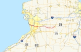
New York State Route 354 (NY 354) is a state highway
in New York
, USA. NY 354 is one of several highways radiating eastward from its western terminus in downtown Buffalo, New York
. The east terminus of NY 354 is in the Village of Attica
, where it ends at NY 98
and NY 238
as West Main Street. This highway runs through the center of Erie County
to the northern county line of Wyoming County
.
NY 354 is known as Clinton Street for the vast majority of its run. However, while Clinton St continues to NY 5 in a straight line, NY 354 diverges for half of a mile, first north on Pine Street and then following William Street to its western terminus at NY 5. NY 354/Clinton Street also changes to West Main Street upon entering the Village of Attica
, 0.7 miles (1.1 km) before its eastern terminus.
, NY 354 begins at the intersection of NY 5
(Ellicott Street) as William Street, heading due east. The intersection also meets NY 130
(Broadway Street), heading northeast. After a half mile on William Street, NY 354 turns south onto Pine Street for 200 feet (61 m), then turns east again, now residing on Clinton Street where it will remain until just before its eastern terminus. Clinton Street continues east through the east side of Buffalo, heading slightly southeast between Filmore Ave and US 62
(Bailey Avenue). An interchange with the Niagara Thruway(I-190
) occurs just east of Bailey Avenue.
Near the city limits, Clinton St continues underneath the main line New York State Thruway
(I-90
) and connects with NY 240
(Harlem Road). Clinton again heads southeast for a little ways before meeting with NY 277
(Union Road), and continuing due east again. Passing through West Seneca
Clinton becomes very suburban. Just before Elma
Clinton becomes busier, meeting US 20
/NY 78
(Transit Road). East of here, Clinton begins to transition from suburban to rural. It continues in a primarily eastward direction through Elma and Marilla
. Through here it intersects with many roads (Bowen Road, Two Rod and Four Rod Roads, Cayuga Creek Road, and Exchange Street) that connect it either to US 20
to the north, or US 20A
to the south, or both. The terrain here begins to turn from primarily flat to small rolling hills. It is now near completely rural.
and the hamlet of Cowlesville. Near Folsomdale, Clinton turns back east, and continues into Bennington Center, where it meets NY 77
(Allegany Road) at a partial cloverleaf interchange. (This was originally designed to eliminate stopping traffic and to eliminate left-hand turns onto 77. The No-Left signs were removed during a construction project in the early 1990s and never put back up.)
After leaving Bennington Center, Clinton street turns again, this time tracking northeast as it nears its end. Upon entering the village of Attica
it becomes West Main Street. NY 354 finally splits off from West Main, heading east to meet with NY 98
. The connector between West Main Street and NY 98 is named the "Attica–Bennington Highway"; however, it is usually just referred to as Clinton Street.
extending from Buffalo
to Batavia
via the hamlets of Marilla
, Wales Center, and Varysburg. When the first set of posted routes in New York
were assigned in 1924, no designation was assigned to the portion of legislative Route 19 between Buffalo and Marilla. It remained unnumbered until the 1930 renumbering of state highways in New York when it became part of NY 354, a route extending from downtown Buffalo to Wales Center via Marilla. At the time, the portion of modern NY 354 from Cowlesville to Attica
was part of NY 239
while the Marilla–Cowlesville segment was unnumbered.
Ca. 1935, NY 354 was realigned to continue east along Clinton Street from Two Rod Road to Exchange Street, where it ended at NY 239. The former routing of NY 354 to Wales Center became part of an extended NY 358
. NY 354 was extended eastward in the late 1940s over NY 239's alignment to a new terminus in Attica. As a result, NY 239 was truncated to its junction with NY 354 in the town of Marilla. NY 354 originally followed West Main Street in the village of Attica all the way to downtown at NY 98. Due to the presence of railroad tracks at its end, the eastern portion of West Main Street features both a sharp turn and a steep downgrade as it enters the village. A new highway bypassing this section of West Main Street, known as the "Attica–Bennington Highway", was built by 1949 as a realignment of NY 354.
State highway
State highway, state road or state route can refer to one of three related concepts, two of them related to a state or provincial government in a country that is divided into states or provinces :#A...
in New York
New York
New York is a state in the Northeastern region of the United States. It is the nation's third most populous state. New York is bordered by New Jersey and Pennsylvania to the south, and by Connecticut, Massachusetts and Vermont to the east...
, USA. NY 354 is one of several highways radiating eastward from its western terminus in downtown Buffalo, New York
Buffalo, New York
Buffalo is the second most populous city in the state of New York, after New York City. Located in Western New York on the eastern shores of Lake Erie and at the head of the Niagara River across from Fort Erie, Ontario, Buffalo is the seat of Erie County and the principal city of the...
. The east terminus of NY 354 is in the Village of Attica
Attica (village), New York
Attica is a village in Wyoming County, New York in the USA. The population was 2,597 at the 2000 census. It is named after a region in Greece.The Village of Attica is on the northern border of Wyoming County...
, where it ends at NY 98
New York State Route 98
New York State Route 98 is a state highway in the western part of New York in the United States. The southern terminus of the route is at an intersection with U.S. Route 219 in the town of Great Valley in Cattaraugus County...
and NY 238
New York State Route 238
New York State Route 238 is a state highway located in Western New York in the United States. It runs in a northwest–southeast direction roughly centered on the village of Attica. In the former direction, it connects to U.S. Route 20 in Darien and serves as a more direct route into...
as West Main Street. This highway runs through the center of Erie County
Erie County, New York
Erie County is a county located in the U.S. state of New York. As of the 2010 census, the population was 919,040. The county seat is Buffalo. The county's name comes from Lake Erie, which in turn comes from the Erie tribe of American Indians who lived south and east of the lake before 1654.Erie...
to the northern county line of Wyoming County
Wyoming County, New York
Wyoming County is a county located in the U.S. state of New York. At the 2010 census, the population was 42,155. The county seat is Warsaw. The name is from a modified Delaware Indian word meaning "broad bottom lands"...
.
NY 354 is known as Clinton Street for the vast majority of its run. However, while Clinton St continues to NY 5 in a straight line, NY 354 diverges for half of a mile, first north on Pine Street and then following William Street to its western terminus at NY 5. NY 354/Clinton Street also changes to West Main Street upon entering the Village of Attica
Attica (village), New York
Attica is a village in Wyoming County, New York in the USA. The population was 2,597 at the 2000 census. It is named after a region in Greece.The Village of Attica is on the northern border of Wyoming County...
, 0.7 miles (1.1 km) before its eastern terminus.
Erie County
Starting in downtown BuffaloBuffalo, New York
Buffalo is the second most populous city in the state of New York, after New York City. Located in Western New York on the eastern shores of Lake Erie and at the head of the Niagara River across from Fort Erie, Ontario, Buffalo is the seat of Erie County and the principal city of the...
, NY 354 begins at the intersection of NY 5
New York State Route 5
New York State Route 5 is a state highway that extends for across the state of New York in the United States. It begins at the Pennsylvania state line in the Chautauqua County town of Ripley and passes through Buffalo, Syracuse, Utica, Schenectady, and several other smaller cities and...
(Ellicott Street) as William Street, heading due east. The intersection also meets NY 130
New York State Route 130
New York State Route 130 is a state highway entirely within Erie County, New York, United States. It runs east–west from U.S. Route 62 in Buffalo to the village of Depew, where it terminates at NY 78...
(Broadway Street), heading northeast. After a half mile on William Street, NY 354 turns south onto Pine Street for 200 feet (61 m), then turns east again, now residing on Clinton Street where it will remain until just before its eastern terminus. Clinton Street continues east through the east side of Buffalo, heading slightly southeast between Filmore Ave and US 62
U.S. Route 62
U.S. Route 62 runs from the US-Mexico border at El Paso, Texas to Niagara Falls, New York, near the United States-Canada border. It is the only east-west US Route that connects Mexico and Canada.Parts of U.S...
(Bailey Avenue). An interchange with the Niagara Thruway(I-190
Interstate 190 (New York)
Interstate 190 runs 28.34 miles from Interstate 90 near Buffalo, New York to Lewiston, New York via Niagara Falls. Parts of this highway were built on the former rights-of-way of the Lehigh Valley Railroad and the Erie Canal. It is referred to by locals as The One-Ninety...
) occurs just east of Bailey Avenue.
Near the city limits, Clinton St continues underneath the main line New York State Thruway
New York State Thruway
The New York State Thruway is a system of limited-access highways located within the state of New York in the United States. The system, known officially as the Governor Thomas E. Dewey Thruway for former New York Governor Thomas E. Dewey, is operated by the New York State Thruway Authority and...
(I-90
Interstate 90 in New York
Interstate 90 is a part of the Interstate Highway System that runs from Seattle, Washington, to Boston, Massachusetts. In the U.S. state of New York, I-90 extends from the Pennsylvania state line at Ripley to the Massachusetts state line at Canaan...
) and connects with NY 240
New York State Route 240
New York State Route 240 is a state highway in western New York in the United States. The southern terminus of the route is at an intersection with NY 242 in the Ellicottville community of Ashford in northern Cattaraugus County. Its northern terminus is at a junction with NY 324...
(Harlem Road). Clinton again heads southeast for a little ways before meeting with NY 277
New York State Route 277
New York State Route 277 is a state highway in New York, USA. This highway is also called Union Road, along with other names. NY 277 is a major north–south road east of Buffalo, New York, through the middle of Erie County...
(Union Road), and continuing due east again. Passing through West Seneca
West Seneca, New York
West Seneca is a town in Erie County, New York, United States. The population was 44,711 at the 2010 census. West Seneca is a centrally-located interior town of the county, and a suburb of Buffalo...
Clinton becomes very suburban. Just before Elma
Elma, New York
Elma is a town in Erie County, New York, United States. The population was 11,304 at the 2000 census. The town is named after a type of tree.The Town of Elma is located in the north-central part of the county, east of Buffalo, New York. Because of its location, Elma likes to refer to itself as the...
Clinton becomes busier, meeting US 20
U.S. Route 20
U.S. Route 20 is an east–west United States highway. As the "0" in its route number implies, US 20 is a coast-to-coast route. Spanning , it is the longest road in the United States, and the route sparsely parallels Interstate 90...
/NY 78
New York State Route 78
New York State Route 78 , most commonly known as Transit Road, is a state highway in Western New York, USA. While it is signed north–south, the lower portion runs in an east–west direction across Wyoming County, from its beginning north of the Village of Gainesville.NY 78 is...
(Transit Road). East of here, Clinton begins to transition from suburban to rural. It continues in a primarily eastward direction through Elma and Marilla
Marilla, New York
Marilla is a town in Erie County, New York, United States. The population was 5,709 at the 2000 census. The name of the town is derived from Marilla Rogers, an early school teacher....
. Through here it intersects with many roads (Bowen Road, Two Rod and Four Rod Roads, Cayuga Creek Road, and Exchange Street) that connect it either to US 20
U.S. Route 20
U.S. Route 20 is an east–west United States highway. As the "0" in its route number implies, US 20 is a coast-to-coast route. Spanning , it is the longest road in the United States, and the route sparsely parallels Interstate 90...
to the north, or US 20A
U.S. Route 20A (New York)
U.S. Route 20A is an east–west alternate route of US 20 that extends for across the western portion of New York in the United States. It leaves US 20 in Hamburg, a suburb of Buffalo, and rejoins it in East Bloomfield about five miles west of Canandaigua, the county seat of...
to the south, or both. The terrain here begins to turn from primarily flat to small rolling hills. It is now near completely rural.
Wyoming County
Clinton Street again turns towards the southeast as it enters Wyoming County in the town of BenningtonBennington, New York
Bennington is a town in Wyoming County, New York in the USA. The population was 3,349 during the 2000 census. The town was named after Bennington, Vermont....
and the hamlet of Cowlesville. Near Folsomdale, Clinton turns back east, and continues into Bennington Center, where it meets NY 77
New York State Route 77
New York State Route 77 is a north–south state highway in the western part of New York in the United States. The highway runs for across mostly rural areas from an intersection with NY 78 and NY 98 in the Wyoming County town of Java to a junction with NY 31 near the city of...
(Allegany Road) at a partial cloverleaf interchange. (This was originally designed to eliminate stopping traffic and to eliminate left-hand turns onto 77. The No-Left signs were removed during a construction project in the early 1990s and never put back up.)
After leaving Bennington Center, Clinton street turns again, this time tracking northeast as it nears its end. Upon entering the village of Attica
Attica (village), New York
Attica is a village in Wyoming County, New York in the USA. The population was 2,597 at the 2000 census. It is named after a region in Greece.The Village of Attica is on the northern border of Wyoming County...
it becomes West Main Street. NY 354 finally splits off from West Main, heading east to meet with NY 98
New York State Route 98
New York State Route 98 is a state highway in the western part of New York in the United States. The southern terminus of the route is at an intersection with U.S. Route 219 in the town of Great Valley in Cattaraugus County...
. The connector between West Main Street and NY 98 is named the "Attica–Bennington Highway"; however, it is usually just referred to as Clinton Street.
History
In 1908, the New York State Legislature created Route 19, an unsigned legislative routeLegislative route
In United States, a legislative route or legislative highway is a highway defined by laws passed in a state legislature. The numbering of such highways may or may not correspond to the numbers familiar to the public as part of the state, U.S. highway, and Interstate highway systems...
extending from Buffalo
Buffalo, New York
Buffalo is the second most populous city in the state of New York, after New York City. Located in Western New York on the eastern shores of Lake Erie and at the head of the Niagara River across from Fort Erie, Ontario, Buffalo is the seat of Erie County and the principal city of the...
to Batavia
Batavia (city), New York
Batavia is a city in Genesee County, Western New York, USA, located near the middle of Genesee County, entirely within the Town of Batavia. Its population as of the 2000 census was 16,256...
via the hamlets of Marilla
Marilla, New York
Marilla is a town in Erie County, New York, United States. The population was 5,709 at the 2000 census. The name of the town is derived from Marilla Rogers, an early school teacher....
, Wales Center, and Varysburg. When the first set of posted routes in New York
New York
New York is a state in the Northeastern region of the United States. It is the nation's third most populous state. New York is bordered by New Jersey and Pennsylvania to the south, and by Connecticut, Massachusetts and Vermont to the east...
were assigned in 1924, no designation was assigned to the portion of legislative Route 19 between Buffalo and Marilla. It remained unnumbered until the 1930 renumbering of state highways in New York when it became part of NY 354, a route extending from downtown Buffalo to Wales Center via Marilla. At the time, the portion of modern NY 354 from Cowlesville to Attica
Attica (village), New York
Attica is a village in Wyoming County, New York in the USA. The population was 2,597 at the 2000 census. It is named after a region in Greece.The Village of Attica is on the northern border of Wyoming County...
was part of NY 239
New York State Route 239
New York State Route 239 was a state highway in eastern Erie County, New York, United States. The southern terminus of the route was at an intersection with NY 354 in Marilla. Its northern terminus was at a junction with U.S. Route 20 in the village of Alden...
while the Marilla–Cowlesville segment was unnumbered.
Ca. 1935, NY 354 was realigned to continue east along Clinton Street from Two Rod Road to Exchange Street, where it ended at NY 239. The former routing of NY 354 to Wales Center became part of an extended NY 358
New York State Route 358
New York State Route 358 was a north–south state highway in Erie County, New York, United States. The southern terminus of the route was at U.S. Route 20A in the hamlet of Wales Center within the town of Wales. Its northern terminus was at U.S. Route 20 in the town of Alden...
. NY 354 was extended eastward in the late 1940s over NY 239's alignment to a new terminus in Attica. As a result, NY 239 was truncated to its junction with NY 354 in the town of Marilla. NY 354 originally followed West Main Street in the village of Attica all the way to downtown at NY 98. Due to the presence of railroad tracks at its end, the eastern portion of West Main Street features both a sharp turn and a steep downgrade as it enters the village. A new highway bypassing this section of West Main Street, known as the "Attica–Bennington Highway", was built by 1949 as a realignment of NY 354.