
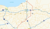
New York State Route 13
Encyclopedia
New York State Route 13 (NY 13) is a state highway
that runs mainly north–south for 152.3 miles (245.1 km) between NY 14
in Horseheads
and NY 3
west of Pulaski
in Central New York
in the United States
. In between, NY 13 intersects with Interstate 81 in Cortland
and Pulaski and meets the New York State Thruway
(Interstate 90) in Canastota
. NY 13 is co-signed with several routes along its routing, most notably NY 34
and NY 96
between Newfield
and Ithaca
; NY 80
between DeRuyter
and Cazenovia
; and NY 5
between Chittenango
and Canastota.
The most heavily traveled section of the route is the 50 miles (80 km) northeast–southwest section between Horseheads and Cortland
. Situated midway between the two locations is the city of Ithaca; here, a small section of NY 13 follows an expressway alignment around much of the city. Much of the route, however, is a two-lane highway that passes through rural areas. When NY 13 was originally assigned in the 1920s, it extended only from Elmira to Cazenovia. It was significantly extended in 1930, stretching from Lindley
in the south to Richland
in the north. The southern terminus was moved back to Elmira in the 1940s and has been located at various points in the city since then.
) southeast of the village of Horseheads
. However, as part of the Horseheads Bypass project, NY 13 was extended west into the village to NY 14 along the frontage roads for the expressway. North of NY 17, NY 13 heads north through the town of Horseheads
, paralleling the eastern edge of the village to an intersection with NY 223
near the northern town line. As NY 13 passes out of Horseheads and into Veteran
, the amount of development along the roadway becomes sparse, consisting of only small roadside hamlets.
Just before exiting Chemung County
, NY 13 turns northeast toward the city of Ithaca several miles to the northeast. The route soon enters the narrow southeastern extents of Schuyler County
, where it intersects NY 224
before crossing county lines again, this time into Tompkins County
. NY 13 remains largely rural in nature, passing only one significant settlement—the Newfield
hamlet of the same name—on its way to the town of Ithaca
. Shortly after entering the town, the route meets with the concurrent
routes of NY 34
and NY 96
at an interchange adjacent to Robert H. Treman State Park
, becoming Elmira Road. Both routes join NY 13 north alongside the eastern edge of the park to NY 327
, a road largely delimiting the northern extent of the park. The three routes proceed generally northeastward through the town of Ithaca to the vicinity of Buttermilk Falls State Park
, where they intersect the south end of NY 13A, an alternate route of NY 13 through western Ithaca, near the former Tutelo
village of Coreogonel at the confluence of Buttermilk Creek and the Cayuga Lake
inlet. NY 13, NY 34, and NY 96 continue on, directly serving Buttermilk Falls State Park as they pass over the creek and inlet and enter the Ithaca city limits.
At West Clinton Street (NY 96B
), the route splits into a one-way pair
, with Meadow Street carrying northbound traffic and Fulton Street handling southbound traffic. Due to the configuration of the city street grid, NY 79
overlaps the three-route concurrency on Fulton Street for one block eastbound as it switches from West State Street to West Green Street; no such overlap exists westbound/northbound as NY 79 westbound remains on West Seneca Street, where NY 96 leaves NY 13/34 and joins NY 79. The one-way pair comes to an end near Hancock Street, at which point both directions of the route merge into Meadow Street and continue northeastward through the city as an at-grade roadway. At Dey Street, however, the road becomes a limited-access highway as it heads through the northern extents of the city and partially alongside Cayuga Lake
.
Near the northern city line, the roadway connects to East Shore Drive by way of an interchange, at which point NY 34 leaves the expressway to follow East Shore Drive along the lakeshore. NY 13 and NY 34 follow parallel routings into Lansing
, where NY 13 curves eastward to interchange with both Cayuga Heights Road and Triphammer Road. Southwest of the Tompkins County Airport, NY 13 downgrades into a divided highway
and meets Warren Road at-grade before reverting into a two-lane roadway as it passes south of the airport and exits the Ithaca area.
 NY 13 progresses southeast through western Dryden
to meet Dryden Road (NY 366
), a street originating in eastern Ithaca. NY 366 joins NY 13 northeast along Fall Creek for little more than 1 miles (1.6 km) before splitting; however, the Dryden Road name remains with NY 13 into the village of Dryden
. At the village center, NY 13 meets both NY 38
and NY 392
. NY 13 turns north, overlapping NY 38 for three blocks and passing Tompkins Cortland Community College
as it exits the village limits on Cortland Road.
 At the Tompkins-Cortland County
line, NY 13 loses the Cortland Road moniker and becomes unnamed as it heads toward Cortland
. Southwest of the city limits, NY 13 breaks to the northeast, with its north-northeastward alignment continuing onward as NY 281
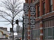
. In Cortland, NY 13 becomes Tompkins Street and meets NY 215
(Owego Street) three blocks from an intersection with the overlapping routes of U.S. Route 11 and NY 41
at Church Street. All three routes turn north onto Church, creating a three-route overlap that lasts for three blocks through downtown Cortland. At Clinton Road, US 11 and NY 41 turn west while NY 13 curves east for several blocks to an interchange with Interstate 81 at the northeastern edge of the city's downtown district. Here, the Tioughnioga River
splits, with NY 13 following the eastern branch northeast out of the Cortland city limits.
NY 13 continues northeast along the banks of the Tioughnioga through Truxton
, where it intersects the southern terminus of NY 91
, to the hamlet of Cuyler in the town of the same name
. Here, the river downgrades to a creek as the route turns eastward toward Madison County
. Upon crossing the county line, NY 13 enters the village of DeRuyter
as Cortland Street. In the village center, NY 13 turns left onto Utica Street and follows the roadway out of the village.
Within the town of DeRuyter
, NY 13 follows a largely northeast–southwest alignment as it passes through the hamlet of Puckerville (centered around the junction between NY 13 and East Lake Road, a local roadway following the eastern edge of the DeRuyter Reservoir) to Sheds, a small hamlet marked by the intersection of NY 13 and NY 80
. NY 13 turns north, overlapping NY 80 north for 3 miles (5 km) to the Cazenovia
community of New Woodstock, where NY 13 leaves NY 80 at the western fringe of the hamlet.
NY 13 heads north to the village of Cazenovia
, located at the southeastern tip of Cazenovia Lake
. Within the village limits, NY 13 overlaps U.S. Route 20 on Forman and Albany Streets before continuing north out of the village on Farnham and Sweetland Streets. In the town, the street becomes known as Gorge Road and enters a roughly 100 feet (30.5 m) ravine surrounding the Chittenango Creek
. As NY 13 progresses northward, the gorge deepens, reaching approximately 300 feet (91.4 m) within Chittenango Falls State Park
. North of the park, the gorge widens laterally and continues to drop in elevation, with the difference between the surrounding terrain and NY 13 reaching almost 500 feet (152.4 m) as it intersects NY 5
in southeastern Chittenango
. The two routes overlap, following Genesee Street north for several blocks before turning east and paralleling the former Erie Canal
out of the village.
The two routes remain conjoined until Canastota
, where NY 13 breaks from NY 5 and resumes its northward progression. North of the village center, NY 13 meets the New York State Thruway
(Interstate 90) at exit 34 before exiting Canastota and entering Lenox
. At the southeastern corner of Oneida Lake
, NY 13 intersects NY 31
. Just north of NY 31, NY 13 crosses over the Oneida River
and enters Oneida County
.
, NY 13 follows the eastern edge of Oneida Lake as it proceeds northward through the towns of Verona
and Vienna
. In Verona, NY 13 passes through the center of Verona Beach State Park
and serves the lakeside community of Verona Beach, located adjacent to where the Erie Canal
exits Oneida Lake. NY 13 crosses over the canal shortly afterward, passing into the Vienna community of Sylvan Beach in the process. Development along NY 13 continues as far north as Edgewater Beach, where NY 13 breaks from the lakeshore and continues north to meet NY 49. NY 13 turns east, overlapping NY 49 into the hamlet of Vienna.
In the center of Vienna, NY 13 leaves NY 49 and continues northward through the hamlet of McConnellsville (where NY 13 is joined by the west branch of Fish Creek) to the village of Camden
, where NY 69
overlaps NY 13 for two blocks through the heart of the village. Past Camden, NY 13 continues northwest along Fish Creek into the Oswego County
town of Williamstown
, where NY 13 leaves the waterway and intersects NY 183
and NY 104
.
NY 13 continues onward through rural central Oswego County to the village of Pulaski
, where the route connects to southbound Interstate 81 by way of a half-interchange just outside the village and intersects U.S. Route 11 near the center of Pulaski. The route continues west for another 3 miles (5 km) before terminating at NY 3
in the town of Richland
.
s in New York
were first publicly signed in 1924, NY 13 was assigned only to the portion of its modern routing between Elmira
and Cazenovia
. Within the Elmira area, NY 13 initially followed a different routing, beginning at the intersection of Lake Street and Water Street (then NY 17
) on the north bank of the Chemung River
in downtown Elmira. The route then overlapped NY 14
along Lake Street to Horseheads
, where NY 13 split from NY 14 and headed northeast on Old Ithaca Road to what is now the intersection between NY 13 and NY 223
. Here, NY 13 turned north, following its current alignment toward Ithaca
.
In the 1930 renumbering of state highways in New York, NY 13 was extended over previously unnumbered roadways on both ends of its alignment. To the south, NY 13 was extended along Water Street (modern NY 352
) to West Elmira, and on what is now NY 225
west to Caton
. Past Caton, NY 13 continued west to NY 2 (now U.S. Route 15) in Lindley
by way of Tannery Creek Road, River Road, and Morgan Creek Road (collectively modern County Route 120). In the north, NY 13 was extended northward along its modern routing to NY 3C (modern NY 3
) west of Pulaski
. By 1940, the portion of NY 13 between Horseheads and Elmira became part of a realigned NY 17.
In the mid-1980s, the Sullivanville Dam project forced a portion of the route to be rerouted northeast of Horseheads. Due to the elevated water level caused by the dam, the route had to be moved to higher ground west of the hamlet of Sullivanville in the Town of Veteran
. A section of the old highway remains under the impounded water. Another section north of the dam exists as an extension of Sullivanville Road.
In 2007, with the completion of the I-86
project, Route 13 was extended westward along the parallel collector/distributor roads to NY 14
in Horseheads. Prior to the project's completion, at least one "NY 13 south" sign assembly was exposed along the westbound frontage road
leading from exit 54 (NY 13). Several similarly shaped signs on similar sign assemblies were covered along the route.
campus to Dryden Road, where it turned eastward toward Dryden
. Ca. 1936, NY 13 was realigned to bypass the Cornell University grounds to the south on State (NY 79
) and Mitchell Streets and Ithaca and Dryden Roads. Its old alignment through the college became NY 392
.
In the early 1960s, a new expressway was built along the eastern shore of Cayuga Lake
, bypassing downtown Ithaca on the west and north. NY 13 was altered to follow Meadow Street and the freeway between southwestern Ithaca and the town of Dryden
while the portion of NY 13's old routing that did not overlap NY 79 became an extension of NY 366
. The new expressway was pictured on the Voyager Golden Record
as an example of a "modern highway." In 1996, ten blocks of southbound NY 13 was diverted from Meadow Street to Fulton Street as part of the Octopus elimination project.
 NY 13A (2.08 miles or 3.35 km) is a north–south spur that bypasses downtown Ithaca
by way of the town of Ithaca
to the southwest. The route begins at NY 13, NY 34
and NY 96
south of the city and follows the west bank of Cayuga Inlet and the Ithaca Flood Control Channel north into the city, where it ends at NY 79
in Ithaca's West End, an area once dominated by squatters' villages. The highway is named Floral Avenue within the city and Five Mile Drive in the town of Ithaca, so named because it is five miles (8 km) from Cayuga Lake
. NY 13A was assigned ca. 1938.
State highway
State highway, state road or state route can refer to one of three related concepts, two of them related to a state or provincial government in a country that is divided into states or provinces :#A...
that runs mainly north–south for 152.3 miles (245.1 km) between NY 14
New York State Route 14
New York State Route 14 is a state highway located in western New York in the United States. Along with NY 19, it is one of two routes to transect the state in a north–south fashion between the Pennsylvania border and Lake Ontario...
in Horseheads
Horseheads (village), New York
Horseheads is a village in Chemung County, New York, USA. The population was 6,461 at the 2010 census. The name is derived from the number of bleached skulls of pack horses left behind by the Sullivan Expedition....
and NY 3
New York State Route 3
New York State Route 3 is a major east–west state highway in New York, United States, that connects central New York to the North Country region near the Canadian border via Adirondack Park. The route extends for between its western terminus at an intersection with NY 104A in the Cayuga...
west of Pulaski
Pulaski, New York
Pulaski is a village in Oswego County, New York, United States. The population was 2,365 at the 2010 census.The Village of Pulaski is within the Town of Richland, and lies between the eastern shore of Lake Ontario and the Tug Hill region. The village is located on US Route 11 and is adjacent to...
in Central New York
Central New York
Central New York is a term used to broadly describe the central region of New York State, roughly including the following counties and cities:...
in the United States
United States
The United States of America is a federal constitutional republic comprising fifty states and a federal district...
. In between, NY 13 intersects with Interstate 81 in Cortland
Cortland, New York
Cortland is a city in Cortland County, New York, USA. As of the 2000 census, the city had a population of 18,740. It is the county seat of Cortland County.The City of Cortland, near the west border of the county, is surrounded by the Town of Cortlandville....
and Pulaski and meets the New York State Thruway
New York State Thruway
The New York State Thruway is a system of limited-access highways located within the state of New York in the United States. The system, known officially as the Governor Thomas E. Dewey Thruway for former New York Governor Thomas E. Dewey, is operated by the New York State Thruway Authority and...
(Interstate 90) in Canastota
Canastota, New York
Canastota is a village located inside the Town of Lenox in Madison County, New York, United States. The population was 4,425 at the 2000 census.The Village of Canastota is in the south part of the Town of Lenox.- History :...
. NY 13 is co-signed with several routes along its routing, most notably NY 34
New York State Route 34
New York State Route 34 is a north–south New York state route located in Central New York. Its southern terminus is at the Pennsylvania state line in the village of Waverly, where it connects to Pennsylvania Route 199 and meets NY 17...
and NY 96
New York State Route 96
New York State Route 96 is a northwest–southeast state highway in the Finger Lakes region of New York in the United States. The southern terminus of the route is at an interchange with NY 17 in the Southern Tier village of Owego, Tioga County. Its northern terminus is at a junction with...
between Newfield
Newfield, New York
Newfield is a town in Tompkins County, New York, United States. The population was 5,108 at the 2000 census. The town's name is derived from the many unoccupied tracts of land that were once in the town....
and Ithaca
Ithaca, New York
The city of Ithaca, is a city in upstate New York and the county seat of Tompkins County, as well as the largest community in the Ithaca-Tompkins County metropolitan area...
; NY 80
New York State Route 80
New York State Route 80 is a west–east New York State Route located within Onondaga, Madison, Chenango, Otsego, Herkimer, and Montgomery Counties in New York. Its western terminus is located at a junction with NY 175 in the city of Syracuse in Onondaga County, from which it...
between DeRuyter
DeRuyter (town), New York
DeRuyter is a town in Madison County, New York, United States. The population was 1,631 at the 2000 census. The town is named after Michiel Adriaenszoon De Ruyter a famous admiral in the Dutch navy....
and Cazenovia
Cazenovia (town), New York
Cazenovia is a town in Madison County, New York, United States. The population was 6,481 at the 2000 census. The town is named after Theophilus Cazenove, an agent of the Holland Land Company.The Town of Cazenovia has a village also named Cazenovia...
; and NY 5
New York State Route 5
New York State Route 5 is a state highway that extends for across the state of New York in the United States. It begins at the Pennsylvania state line in the Chautauqua County town of Ripley and passes through Buffalo, Syracuse, Utica, Schenectady, and several other smaller cities and...
between Chittenango
Chittenango, New York
Chittenango is a village located in Madison County, New York, in the United States. The village is in the south part of the Town of Sullivan. The population was 5,081 at the 2010 census.- History :...
and Canastota.
The most heavily traveled section of the route is the 50 miles (80 km) northeast–southwest section between Horseheads and Cortland
Cortland, New York
Cortland is a city in Cortland County, New York, USA. As of the 2000 census, the city had a population of 18,740. It is the county seat of Cortland County.The City of Cortland, near the west border of the county, is surrounded by the Town of Cortlandville....
. Situated midway between the two locations is the city of Ithaca; here, a small section of NY 13 follows an expressway alignment around much of the city. Much of the route, however, is a two-lane highway that passes through rural areas. When NY 13 was originally assigned in the 1920s, it extended only from Elmira to Cazenovia. It was significantly extended in 1930, stretching from Lindley
Lindley, New York
Lindley is a town in southern Steuben County, New York, United States. The population was 1,913 at the 2000 census. The town was named after the early settler Eleazer Lindsley.The town is situated south of the city of Corning.-Geography:...
in the south to Richland
Richland, New York
Richland is a town in Oswego County, New York, United States. The population was 5,824 at the 2000 census.The Town of Richland is in the northeast part of Oswego County.- History :The town was first settled around 1801....
in the north. The southern terminus was moved back to Elmira in the 1940s and has been located at various points in the city since then.
Elmira to Ithaca
Up until 2006, NY 13 began at exit 54 on the Southern Tier Expressway (NY 17New York State Route 17
New York State Route 17 is a state highway that extends for through the Southern Tier and Downstate regions of New York in the United States...
) southeast of the village of Horseheads
Horseheads (village), New York
Horseheads is a village in Chemung County, New York, USA. The population was 6,461 at the 2010 census. The name is derived from the number of bleached skulls of pack horses left behind by the Sullivan Expedition....
. However, as part of the Horseheads Bypass project, NY 13 was extended west into the village to NY 14 along the frontage roads for the expressway. North of NY 17, NY 13 heads north through the town of Horseheads
Horseheads (town), New York
Horseheads is a town in Chemung County, New York, United States. The population was 19,561 at the 2000 census. The name of the town is derived from the number of bleached horses' skulls found there....
, paralleling the eastern edge of the village to an intersection with NY 223
New York State Route 223
New York State Route 223 is an east–west state highway in Chemung County, New York, United States. The western terminus of the route is at NY 13 in the town of Horseheads, northeast of the city of Elmira. Its eastern terminus is at NY 224 in the town of Van Etten...
near the northern town line. As NY 13 passes out of Horseheads and into Veteran
Veteran, New York
Veteran is a town in Chemung County, New York, United States. It is part of the 'Elmira, New York Metropolitan Statistical Area'. The population was 3,271 at the 2000 census...
, the amount of development along the roadway becomes sparse, consisting of only small roadside hamlets.
Just before exiting Chemung County
Chemung County, New York
Chemung County is a county located in the U.S. state of New York. It is part of the 'Elmira, New York Metropolitan Statistical Area' which encompasses all of Chemung County. As of the 2010 census, the population was 88,830. Its name is derived from the name of a Delaware Indian village . Its...
, NY 13 turns northeast toward the city of Ithaca several miles to the northeast. The route soon enters the narrow southeastern extents of Schuyler County
Schuyler County, New York
As of the census of 2000, there were 19,224 people, 7,374 households, and 5,191 families residing in the county. The population density was 58 people per square mile . There were 9,181 housing units at an average density of 28 per square mile...
, where it intersects NY 224
New York State Route 224
New York State Route 224 is a state highway in the Southern Tier of New York, United States. The route is signed as north–south; however, in actuality the highway follows more of an east–west routing across southeastern Schuyler County and northeastern Chemung County...
before crossing county lines again, this time into Tompkins County
Tompkins County, New York
Tompkins County is a county located in the U.S. state of New York, and comprises the whole of the Ithaca metropolitan area. As of the 2010 census, the population was 101,564. The county seat is Ithaca, and the county is home to Cornell University, Ithaca College and Tompkins Cortland Community...
. NY 13 remains largely rural in nature, passing only one significant settlement—the Newfield
Newfield, New York
Newfield is a town in Tompkins County, New York, United States. The population was 5,108 at the 2000 census. The town's name is derived from the many unoccupied tracts of land that were once in the town....
hamlet of the same name—on its way to the town of Ithaca
Ithaca (town), New York
Ithaca is a town in Tompkins County, New York, United States. The population was 18,198 at the 2000 census.The Town of Ithaca is a horseshoe-shaped portion of the metropolitan area of Ithaca, New York. It surrounds the City of Ithaca and is the City's only border, although the City has a...
. Shortly after entering the town, the route meets with the concurrent
Concurrency (road)
A concurrency, overlap, or coincidence in a road network is an instance of one physical road bearing two or more different highway, motorway, or other route numbers...
routes of NY 34
New York State Route 34
New York State Route 34 is a north–south New York state route located in Central New York. Its southern terminus is at the Pennsylvania state line in the village of Waverly, where it connects to Pennsylvania Route 199 and meets NY 17...
and NY 96
New York State Route 96
New York State Route 96 is a northwest–southeast state highway in the Finger Lakes region of New York in the United States. The southern terminus of the route is at an interchange with NY 17 in the Southern Tier village of Owego, Tioga County. Its northern terminus is at a junction with...
at an interchange adjacent to Robert H. Treman State Park
Robert H. Treman State Park
Robert H. Treman State Park is a state park located in Tompkins County, New York in the United States. The park is located along State Route 327, just west of State Routes 13, 34, and 96, situated in the Towns of Ithaca, Enfield and Newfield....
, becoming Elmira Road. Both routes join NY 13 north alongside the eastern edge of the park to NY 327
New York State Route 327
New York State Route 327 is a state highway in New York State. It begins at the NY 13/NY 34/NY 96 concurrency in the Town of Ithaca and ends at NY 79 in the Town of Enfield. It is located entirely within Tompkins County.-Route description:Route 327 begins at an...
, a road largely delimiting the northern extent of the park. The three routes proceed generally northeastward through the town of Ithaca to the vicinity of Buttermilk Falls State Park
Buttermilk Falls State Park
Buttermilk Falls State Park is located southwest of Ithaca, New York, USA. Like Robert H. Treman State Park, the initial grant of land for the park came from Robert and Laura Treman, in 1924....
, where they intersect the south end of NY 13A, an alternate route of NY 13 through western Ithaca, near the former Tutelo
Tutelo
The Tutelo were Native people living above the Fall Line in present-day Virginia and West Virginia, speaking a Siouan dialect of the Tutelo language thought to be similar to that of their neighbors, the Monacan and Manahoac nations...
village of Coreogonel at the confluence of Buttermilk Creek and the Cayuga Lake
Cayuga Lake
Cayuga Lake is the longest of central New York's glacial Finger Lakes, and is the second largest in surface area and second largest in volume. It is just under 40 miles long. Its average width is 1.7 miles , and it is at its widest point near Aurora...
inlet. NY 13, NY 34, and NY 96 continue on, directly serving Buttermilk Falls State Park as they pass over the creek and inlet and enter the Ithaca city limits.
At West Clinton Street (NY 96B
New York State Route 96B
New York State Route 96B is a north–south state highway in the Southern Tier of New York, United States. It connects NY 96 in the village of Candor in Tioga County to NY 13, NY 34, and NY 96 in the city of Ithaca in Tompkins County...
), the route splits into a one-way pair
One-way pair
A one-way pair, one-way couple, or just couplet is a pair of parallel, usually one-way streets that carry opposite directions of a signed route or major traffic flow, or sometimes opposite directions of a bus or streetcar route....
, with Meadow Street carrying northbound traffic and Fulton Street handling southbound traffic. Due to the configuration of the city street grid, NY 79
New York State Route 79
New York State Route 79 is an east–west state highway in the Southern Tier of New York, United States. The western terminus of the route is at the intersection with NY 414 near the southern end of Seneca Lake east of Watkins Glen...
overlaps the three-route concurrency on Fulton Street for one block eastbound as it switches from West State Street to West Green Street; no such overlap exists westbound/northbound as NY 79 westbound remains on West Seneca Street, where NY 96 leaves NY 13/34 and joins NY 79. The one-way pair comes to an end near Hancock Street, at which point both directions of the route merge into Meadow Street and continue northeastward through the city as an at-grade roadway. At Dey Street, however, the road becomes a limited-access highway as it heads through the northern extents of the city and partially alongside Cayuga Lake
Cayuga Lake
Cayuga Lake is the longest of central New York's glacial Finger Lakes, and is the second largest in surface area and second largest in volume. It is just under 40 miles long. Its average width is 1.7 miles , and it is at its widest point near Aurora...
.
Near the northern city line, the roadway connects to East Shore Drive by way of an interchange, at which point NY 34 leaves the expressway to follow East Shore Drive along the lakeshore. NY 13 and NY 34 follow parallel routings into Lansing
Lansing (village), New York
Lansing is a village in Tompkins County, New York, United States. The population was 3,417 at the 2000 census.The Village of Lansing is in the Town of Lansing and is north of Ithaca....
, where NY 13 curves eastward to interchange with both Cayuga Heights Road and Triphammer Road. Southwest of the Tompkins County Airport, NY 13 downgrades into a divided highway
Divided Highway
Divided Highway is a compilation album by American rock band The Doobie Brothers, released in 2003. . All tracks are taken from the albums Cycles and Brotherhood .-Track listing:...
and meets Warren Road at-grade before reverting into a two-lane roadway as it passes south of the airport and exits the Ithaca area.
Ithaca to Lenox
Dryden (town), New York
Dryden is a town in Tompkins County, New York, USA. The population was 13,532 at the 2000 census. The town contains two villages: one also named Dryden and one named Freeville...
to meet Dryden Road (NY 366
New York State Route 366
New York State Route 366 is an east–west state highway located entirely within Tompkins County in the Finger Lakes region of New York in the United States. It runs for from State Street just east of downtown Ithaca to NY 38 in Freeville...
), a street originating in eastern Ithaca. NY 366 joins NY 13 northeast along Fall Creek for little more than 1 miles (1.6 km) before splitting; however, the Dryden Road name remains with NY 13 into the village of Dryden
Dryden (village), New York
Dryden is a village in Tompkins County, New York, United States. The population was 1,832 at the 2000 census. The name was assigned by a clerk interested in the classics to honor John Dryden, poet and playwright....
. At the village center, NY 13 meets both NY 38
New York State Route 38
New York State Route 38 is a north–south state highway in the Finger Lakes region of New York in the United States. Its southern terminus is at an intersection with NY 96 in the town of Owego in Tioga County. The northern terminus is at a junction with NY 104A in the town of...
and NY 392
New York State Route 392
New York State Route 392 is an east–west state highway in south-central New York, United States. The western terminus of the route is at an intersection with the concurrency of NY 13 and NY 38 in the village of Dryden in Tompkins County. Its eastern terminus is at a junction with U.S...
. NY 13 turns north, overlapping NY 38 for three blocks and passing Tompkins Cortland Community College
Tompkins Cortland Community College
Tompkins Cortland Community College is a public two-year college supported by Cortland and Tompkins Counties. The main college campus is located in the Town of Dryden. Extension sites are located in Cortland, New York and Ithaca, New York...
as it exits the village limits on Cortland Road.
Cortland County, New York
Cortland County is a county located in the U.S. state of New York, named after Federico Van Cortlandt, president of the convention at Kingston that wrote the first New York State Constitution in 1777, and first lieutenant governor of the state. The county seat is Cortland...
line, NY 13 loses the Cortland Road moniker and becomes unnamed as it heads toward Cortland
Cortland, New York
Cortland is a city in Cortland County, New York, USA. As of the 2000 census, the city had a population of 18,740. It is the county seat of Cortland County.The City of Cortland, near the west border of the county, is surrounded by the Town of Cortlandville....
. Southwest of the city limits, NY 13 breaks to the northeast, with its north-northeastward alignment continuing onward as NY 281
New York State Route 281
New York State Route 281 is a north–south state highway in central New York, United States. It extends for across Cortland and Onondaga Counties. The southern terminus of the route is at an intersection with NY 13 in the town of Cortlandville. Its northern terminus is at a junction with...
. In Cortland, NY 13 becomes Tompkins Street and meets NY 215
New York State Route 215
New York State Route 215 is a north–south state highway located entirely within Cortland County, New York, in the United States. It extends for just over from an intersection with NY 392 in the town of Virgil to a junction with NY 13 in the city of Cortland...
(Owego Street) three blocks from an intersection with the overlapping routes of U.S. Route 11 and NY 41
New York State Route 41
New York State Route 41 is a north–south state highway in Central New York, United States. The southern terminus of the route is at an interchange with NY 17 in the town of Sanford. Its northern terminus is at an intersection with U.S. Route 20 in the village of Skaneateles...
at Church Street. All three routes turn north onto Church, creating a three-route overlap that lasts for three blocks through downtown Cortland. At Clinton Road, US 11 and NY 41 turn west while NY 13 curves east for several blocks to an interchange with Interstate 81 at the northeastern edge of the city's downtown district. Here, the Tioughnioga River
Tioughnioga River
The Tioughnioga River is a tributary of the Chenango River in central New York in the United States. It drains a dissected plateau area east of the Finger Lakes at the northernmost edge of the watershed of the Susquehanna River....
splits, with NY 13 following the eastern branch northeast out of the Cortland city limits.
NY 13 continues northeast along the banks of the Tioughnioga through Truxton
Truxton, New York
Truxton is a town in Cortland County, New York, United States. The population was 1,225 at the 2000 census. The town was named for Commodore Thomas Truxton, a naval officer of the American Revolution....
, where it intersects the southern terminus of NY 91
New York State Route 91
New York State Route 91 is a north–south state highway in Central New York in the United States. The southern terminus of the route is located at an intersection with NY 13 in the Cortland County town of Truxton. Its northern terminus is located at a junction with NY 173 in...
, to the hamlet of Cuyler in the town of the same name
Cuyler, New York
Cuyler is a town in Cortland County, New York, United States. The population was 1,036 at the 2000 census.The Town of Cuyler is in the northeast part of Cortland County and is northeast of the City of Cortland.- History :...
. Here, the river downgrades to a creek as the route turns eastward toward Madison County
Madison County, New York
Madison County is a county located in the U.S. state of New York. As of the 2010 census, the population was 73,442. It is named after James Madison, fourth President of the United States of America...
. Upon crossing the county line, NY 13 enters the village of DeRuyter
DeRuyter (village), New York
DeRuyter is a village located in the Town of DeRuyter in Madison County, New York, USA. The population was 531 at the 2000 census. The village and town are named after Michiel Adriaenszoon De Ruyter, a famous admiral in the Dutch navy....
as Cortland Street. In the village center, NY 13 turns left onto Utica Street and follows the roadway out of the village.
Within the town of DeRuyter
DeRuyter (town), New York
DeRuyter is a town in Madison County, New York, United States. The population was 1,631 at the 2000 census. The town is named after Michiel Adriaenszoon De Ruyter a famous admiral in the Dutch navy....
, NY 13 follows a largely northeast–southwest alignment as it passes through the hamlet of Puckerville (centered around the junction between NY 13 and East Lake Road, a local roadway following the eastern edge of the DeRuyter Reservoir) to Sheds, a small hamlet marked by the intersection of NY 13 and NY 80
New York State Route 80
New York State Route 80 is a west–east New York State Route located within Onondaga, Madison, Chenango, Otsego, Herkimer, and Montgomery Counties in New York. Its western terminus is located at a junction with NY 175 in the city of Syracuse in Onondaga County, from which it...
. NY 13 turns north, overlapping NY 80 north for 3 miles (5 km) to the Cazenovia
Cazenovia (town), New York
Cazenovia is a town in Madison County, New York, United States. The population was 6,481 at the 2000 census. The town is named after Theophilus Cazenove, an agent of the Holland Land Company.The Town of Cazenovia has a village also named Cazenovia...
community of New Woodstock, where NY 13 leaves NY 80 at the western fringe of the hamlet.
NY 13 heads north to the village of Cazenovia
Cazenovia (village), New York
Cazenovia is a village located in the Town of Cazenovia in Madison County, New York, United States. As of the 2000 census, the village had a population of 2,614. The village lies on the southeast shore of Cazenovia Lake, which is approximately long and .5 miles across...
, located at the southeastern tip of Cazenovia Lake
Cazenovia Lake
Cazenovia Lake is a lake in New York, United States. It is located 20 miles from Syracuse, New York. Cazenovia, New York is located southeast of the lake. The lake is roughly 4 miles long and 0.5 mile wide...
. Within the village limits, NY 13 overlaps U.S. Route 20 on Forman and Albany Streets before continuing north out of the village on Farnham and Sweetland Streets. In the town, the street becomes known as Gorge Road and enters a roughly 100 feet (30.5 m) ravine surrounding the Chittenango Creek
Chittenango Creek
Chittenango Creek is a small river in central New York, USA. Chittenango Creek flows northward through Chittenango into Oneida Lake near the community of Bridgeport and partially forms the boundary between Onondaga County and Madison County...
. As NY 13 progresses northward, the gorge deepens, reaching approximately 300 feet (91.4 m) within Chittenango Falls State Park
Chittenango Falls State Park
Chittenango Falls State Park is located in Madison County, New York east of Cazenovia Lake. The 167 foot waterfall cascades over roughly 400 million year old bedrock, flowing beneath a wooden bridge spanning the meandering Chittenango Creek. The park offers a variety of activities:The park offers...
. North of the park, the gorge widens laterally and continues to drop in elevation, with the difference between the surrounding terrain and NY 13 reaching almost 500 feet (152.4 m) as it intersects NY 5
New York State Route 5
New York State Route 5 is a state highway that extends for across the state of New York in the United States. It begins at the Pennsylvania state line in the Chautauqua County town of Ripley and passes through Buffalo, Syracuse, Utica, Schenectady, and several other smaller cities and...
in southeastern Chittenango
Chittenango, New York
Chittenango is a village located in Madison County, New York, in the United States. The village is in the south part of the Town of Sullivan. The population was 5,081 at the 2010 census.- History :...
. The two routes overlap, following Genesee Street north for several blocks before turning east and paralleling the former Erie Canal
Erie Canal
The Erie Canal is a waterway in New York that runs about from Albany, New York, on the Hudson River to Buffalo, New York, at Lake Erie, completing a navigable water route from the Atlantic Ocean to the Great Lakes. The canal contains 36 locks and encompasses a total elevation differential of...
out of the village.
The two routes remain conjoined until Canastota
Canastota, New York
Canastota is a village located inside the Town of Lenox in Madison County, New York, United States. The population was 4,425 at the 2000 census.The Village of Canastota is in the south part of the Town of Lenox.- History :...
, where NY 13 breaks from NY 5 and resumes its northward progression. North of the village center, NY 13 meets the New York State Thruway
New York State Thruway
The New York State Thruway is a system of limited-access highways located within the state of New York in the United States. The system, known officially as the Governor Thomas E. Dewey Thruway for former New York Governor Thomas E. Dewey, is operated by the New York State Thruway Authority and...
(Interstate 90) at exit 34 before exiting Canastota and entering Lenox
Lenox, New York
Lenox is a town in Madison County, New York, United States. The population was 8,665 as of the 2000 census.The Town of Lenox is on the county's northern border. It is west of the City of Oneida.- History :...
. At the southeastern corner of Oneida Lake
Oneida Lake
Oneida Lake is the largest lake entirely within New York State . The lake is located northeast of Syracuse and near the Great Lakes. It serves as one of the links in the Erie Canal. It empties into the Oneida River which flows into the Oswego River which in turn flows into Lake Ontario...
, NY 13 intersects NY 31
New York State Route 31
New York State Route 31 is a state highway that extends for across western and central New York in the United States. The western terminus of the route is at an intersection with NY 104 in the city of Niagara Falls. Its eastern terminus is at a traffic circle with NY 26 in Vernon...
. Just north of NY 31, NY 13 crosses over the Oneida River
Oneida River
The Oneida River in central New York state flows from Oneida Lake to its confluence with the Seneca and Oswego rivers. The Oswego empties the water of the other two rivers into Lake Ontario....
and enters Oneida County
Oneida County, New York
Oneida County is a county located in the U.S. state of New York. As of the 2010 census, the population was 234,878. The county seat is Utica. The name is in honor of the Oneida, an Iroquoian tribe that formerly occupied the region....
.
Oneida and Oswego Counties
Between the county line and NY 49New York State Route 49
New York State Route 49 is an east–west state highway in New York in the United States. It runs from NY 3 in Volney to Interstate 790 , NY 5, NY 8 and NY 12 in Utica...
, NY 13 follows the eastern edge of Oneida Lake as it proceeds northward through the towns of Verona
Verona, New York
Verona is a town in Oneida County, New York, United States. The population was 6,425 at the 2000 census. The source of the town name is unknown, though it's possibly named after Verona, Italy....
and Vienna
Vienna, New York
Vienna is a town in Oneida County, New York, United States. The population was 5,819 at the 2000 census. The town is named after the capital of Austria.The Town of Vienna is in the western part of the county.- History :...
. In Verona, NY 13 passes through the center of Verona Beach State Park
Verona Beach State Park
Verona Beach State Park is located on Route 13 in the Town of Verona, Oneida County, New York. The park is northwest of the City of Oneida and south of Sylvan Beach...
and serves the lakeside community of Verona Beach, located adjacent to where the Erie Canal
Erie Canal
The Erie Canal is a waterway in New York that runs about from Albany, New York, on the Hudson River to Buffalo, New York, at Lake Erie, completing a navigable water route from the Atlantic Ocean to the Great Lakes. The canal contains 36 locks and encompasses a total elevation differential of...
exits Oneida Lake. NY 13 crosses over the canal shortly afterward, passing into the Vienna community of Sylvan Beach in the process. Development along NY 13 continues as far north as Edgewater Beach, where NY 13 breaks from the lakeshore and continues north to meet NY 49. NY 13 turns east, overlapping NY 49 into the hamlet of Vienna.
In the center of Vienna, NY 13 leaves NY 49 and continues northward through the hamlet of McConnellsville (where NY 13 is joined by the west branch of Fish Creek) to the village of Camden
Camden (village), New York
Camden is a village in Oneida County, New York, USA. The population was 2,330 at the 2000 census.The Village of Camden is located inside the Town of Camden at the crossing of Routes NY-13 and NY-69.-History:The W.H...
, where NY 69
New York State Route 69
New York State Route 69 is a state highway extending for across the central portion of the U.S. state of New York. The western terminus of the route is at NY 104 in the Oswego County village of Mexico. The eastern terminus is at NY 5A in the Oneida County village of Yorkville, just...
overlaps NY 13 for two blocks through the heart of the village. Past Camden, NY 13 continues northwest along Fish Creek into the Oswego County
Oswego County, New York
Oswego County is a county located in the U.S. state of New York. As of the 2010 Census, the estimated population was 122,109. The City of Oswego and the Village of Pulaski serve as the dual county seats in a two shire system of government...
town of Williamstown
Williamstown, New York
Williamstown is a town in Oswego County, New York, United States. The population was 1,350 at the 2000 census.The Town of Williamstown is on the county's east border.- History :The Town of Williamstown was created in 1804 from the Town of Mexico....
, where NY 13 leaves the waterway and intersects NY 183
New York State Route 183
New York State Route 183 is a state highway located within Oswego County, New York, United States. The southern terminus is at an intersection with NY 69 in the hamlet of Amboy Center within the town of Amboy...
and NY 104
New York State Route 104
New York State Route 104 is a long east–west state highway in Upstate New York, United States. It spans six counties and enters the vicinity of four cities—Niagara Falls, Lockport, Rochester, and Oswego—as it follows a routing largely parallel to that of the southern shoreline of Lake...
.
NY 13 continues onward through rural central Oswego County to the village of Pulaski
Pulaski, New York
Pulaski is a village in Oswego County, New York, United States. The population was 2,365 at the 2010 census.The Village of Pulaski is within the Town of Richland, and lies between the eastern shore of Lake Ontario and the Tug Hill region. The village is located on US Route 11 and is adjacent to...
, where the route connects to southbound Interstate 81 by way of a half-interchange just outside the village and intersects U.S. Route 11 near the center of Pulaski. The route continues west for another 3 miles (5 km) before terminating at NY 3
New York State Route 3
New York State Route 3 is a major east–west state highway in New York, United States, that connects central New York to the North Country region near the Canadian border via Adirondack Park. The route extends for between its western terminus at an intersection with NY 104A in the Cayuga...
in the town of Richland
Richland, New York
Richland is a town in Oswego County, New York, United States. The population was 5,824 at the 2000 census.The Town of Richland is in the northeast part of Oswego County.- History :The town was first settled around 1801....
.
Early routing
When state highwayState highway
State highway, state road or state route can refer to one of three related concepts, two of them related to a state or provincial government in a country that is divided into states or provinces :#A...
s in New York
New York
New York is a state in the Northeastern region of the United States. It is the nation's third most populous state. New York is bordered by New Jersey and Pennsylvania to the south, and by Connecticut, Massachusetts and Vermont to the east...
were first publicly signed in 1924, NY 13 was assigned only to the portion of its modern routing between Elmira
Elmira, New York
Elmira is a city in Chemung County, New York, USA. It is the principal city of the 'Elmira, New York Metropolitan Statistical Area' which encompasses Chemung County, New York. The population was 29,200 at the 2010 census. It is the county seat of Chemung County.The City of Elmira is located in...
and Cazenovia
Cazenovia (village), New York
Cazenovia is a village located in the Town of Cazenovia in Madison County, New York, United States. As of the 2000 census, the village had a population of 2,614. The village lies on the southeast shore of Cazenovia Lake, which is approximately long and .5 miles across...
. Within the Elmira area, NY 13 initially followed a different routing, beginning at the intersection of Lake Street and Water Street (then NY 17
New York State Route 17
New York State Route 17 is a state highway that extends for through the Southern Tier and Downstate regions of New York in the United States...
) on the north bank of the Chemung River
Chemung River
The Chemung River is a tributary of the Susquehanna River, approximately long, in south central New York and northern Pennsylvania in the United States. It drains a mountainous region of the northern Allegheny Plateau in the Southern Tier of New York...
in downtown Elmira. The route then overlapped NY 14
New York State Route 14
New York State Route 14 is a state highway located in western New York in the United States. Along with NY 19, it is one of two routes to transect the state in a north–south fashion between the Pennsylvania border and Lake Ontario...
along Lake Street to Horseheads
Horseheads (village), New York
Horseheads is a village in Chemung County, New York, USA. The population was 6,461 at the 2010 census. The name is derived from the number of bleached skulls of pack horses left behind by the Sullivan Expedition....
, where NY 13 split from NY 14 and headed northeast on Old Ithaca Road to what is now the intersection between NY 13 and NY 223
New York State Route 223
New York State Route 223 is an east–west state highway in Chemung County, New York, United States. The western terminus of the route is at NY 13 in the town of Horseheads, northeast of the city of Elmira. Its eastern terminus is at NY 224 in the town of Van Etten...
. Here, NY 13 turned north, following its current alignment toward Ithaca
Ithaca, New York
The city of Ithaca, is a city in upstate New York and the county seat of Tompkins County, as well as the largest community in the Ithaca-Tompkins County metropolitan area...
.
In the 1930 renumbering of state highways in New York, NY 13 was extended over previously unnumbered roadways on both ends of its alignment. To the south, NY 13 was extended along Water Street (modern NY 352
New York State Route 352
New York State Route 352 is a state highway in the Southern Tier of New York, United States. It generally parallels the Southern Tier Expressway from the village of Riverside east through the city of Corning to the city of Elmira...
) to West Elmira, and on what is now NY 225
New York State Route 225
New York State Route 225 is a state highway in the Southern Tier of New York, United States. It is a loop route off NY 352 that connects the town of Big Flats and the city of Corning to the hamlet of Caton within the town of the same name...
west to Caton
Caton, New York
Caton is a town in Steuben County, New York, United States. The population was 2,097 at the 2000 census. The town is named after Richard Caton.The Town of Caton is in the southeast part of the county, south of Corning, New York.- History :...
. Past Caton, NY 13 continued west to NY 2 (now U.S. Route 15) in Lindley
Lindley, New York
Lindley is a town in southern Steuben County, New York, United States. The population was 1,913 at the 2000 census. The town was named after the early settler Eleazer Lindsley.The town is situated south of the city of Corning.-Geography:...
by way of Tannery Creek Road, River Road, and Morgan Creek Road (collectively modern County Route 120). In the north, NY 13 was extended northward along its modern routing to NY 3C (modern NY 3
New York State Route 3
New York State Route 3 is a major east–west state highway in New York, United States, that connects central New York to the North Country region near the Canadian border via Adirondack Park. The route extends for between its western terminus at an intersection with NY 104A in the Cayuga...
) west of Pulaski
Pulaski, New York
Pulaski is a village in Oswego County, New York, United States. The population was 2,365 at the 2010 census.The Village of Pulaski is within the Town of Richland, and lies between the eastern shore of Lake Ontario and the Tug Hill region. The village is located on US Route 11 and is adjacent to...
. By 1940, the portion of NY 13 between Horseheads and Elmira became part of a realigned NY 17.
Realignments and truncation
The portion of NY 13 west of Elmira was removed from the state highway system in the early 1940s. NY 13 was truncated back to its original terminus at Water Street in downtown Elmira even though all of NY 13 south of Horseheads was concurrent with NY 17. NY 17 was moved onto its current alignment east of the city in the late 1950s; NY 13 was realigned south of NY 223 ca. 1961 to follow a new road leading to a newly-constructed interchange with NY 17.In the mid-1980s, the Sullivanville Dam project forced a portion of the route to be rerouted northeast of Horseheads. Due to the elevated water level caused by the dam, the route had to be moved to higher ground west of the hamlet of Sullivanville in the Town of Veteran
Veteran, New York
Veteran is a town in Chemung County, New York, United States. It is part of the 'Elmira, New York Metropolitan Statistical Area'. The population was 3,271 at the 2000 census...
. A section of the old highway remains under the impounded water. Another section north of the dam exists as an extension of Sullivanville Road.
In 2007, with the completion of the I-86
Interstate 86 (east)
Interstate 86 is an Interstate Highway that extends for through northwestern Pennsylvania and southern New York in the United States...
project, Route 13 was extended westward along the parallel collector/distributor roads to NY 14
New York State Route 14
New York State Route 14 is a state highway located in western New York in the United States. Along with NY 19, it is one of two routes to transect the state in a north–south fashion between the Pennsylvania border and Lake Ontario...
in Horseheads. Prior to the project's completion, at least one "NY 13 south" sign assembly was exposed along the westbound frontage road
Frontage road
A frontage road is a non-limited access road running parallel to a higher-speed road, usually a freeway, and feeding it at appropriate points of access...
leading from exit 54 (NY 13). Several similarly shaped signs on similar sign assemblies were covered along the route.
Routing through Ithaca
When NY 13 was first assigned, it entered the city of Ithaca on Spencer Road and followed Spencer and Cayuga Streets into downtown. From there, NY 13 proceeded generally northeastward on Court and Linn Streets, University Avenue, and Forest Home Drive through the Cornell UniversityCornell University
Cornell University is an Ivy League university located in Ithaca, New York, United States. It is a private land-grant university, receiving annual funding from the State of New York for certain educational missions...
campus to Dryden Road, where it turned eastward toward Dryden
Dryden (village), New York
Dryden is a village in Tompkins County, New York, United States. The population was 1,832 at the 2000 census. The name was assigned by a clerk interested in the classics to honor John Dryden, poet and playwright....
. Ca. 1936, NY 13 was realigned to bypass the Cornell University grounds to the south on State (NY 79
New York State Route 79
New York State Route 79 is an east–west state highway in the Southern Tier of New York, United States. The western terminus of the route is at the intersection with NY 414 near the southern end of Seneca Lake east of Watkins Glen...
) and Mitchell Streets and Ithaca and Dryden Roads. Its old alignment through the college became NY 392
New York State Route 392 (1930s–1970s)
New York State Route 392 was a state highway in the vicinity of the city of Ithaca in central Tompkins County, New York, United States. The western terminus of the route was at an intersection with NY 79 in downtown Ithaca. Its eastern terminus was at a junction with NY 366 in the...
.
In the early 1960s, a new expressway was built along the eastern shore of Cayuga Lake
Cayuga Lake
Cayuga Lake is the longest of central New York's glacial Finger Lakes, and is the second largest in surface area and second largest in volume. It is just under 40 miles long. Its average width is 1.7 miles , and it is at its widest point near Aurora...
, bypassing downtown Ithaca on the west and north. NY 13 was altered to follow Meadow Street and the freeway between southwestern Ithaca and the town of Dryden
Dryden (town), New York
Dryden is a town in Tompkins County, New York, USA. The population was 13,532 at the 2000 census. The town contains two villages: one also named Dryden and one named Freeville...
while the portion of NY 13's old routing that did not overlap NY 79 became an extension of NY 366
New York State Route 366
New York State Route 366 is an east–west state highway located entirely within Tompkins County in the Finger Lakes region of New York in the United States. It runs for from State Street just east of downtown Ithaca to NY 38 in Freeville...
. The new expressway was pictured on the Voyager Golden Record
Voyager Golden Record
The Voyager Golden Records are phonograph records which were included aboard both Voyager spacecraft, which were launched in 1977. They contain sounds and images selected to portray the diversity of life and culture on Earth, and are intended for any intelligent extraterrestrial life form, or for...
as an example of a "modern highway." In 1996, ten blocks of southbound NY 13 was diverted from Meadow Street to Fulton Street as part of the Octopus elimination project.
NY 13A
Ithaca, New York
The city of Ithaca, is a city in upstate New York and the county seat of Tompkins County, as well as the largest community in the Ithaca-Tompkins County metropolitan area...
by way of the town of Ithaca
Ithaca (town), New York
Ithaca is a town in Tompkins County, New York, United States. The population was 18,198 at the 2000 census.The Town of Ithaca is a horseshoe-shaped portion of the metropolitan area of Ithaca, New York. It surrounds the City of Ithaca and is the City's only border, although the City has a...
to the southwest. The route begins at NY 13, NY 34
New York State Route 34
New York State Route 34 is a north–south New York state route located in Central New York. Its southern terminus is at the Pennsylvania state line in the village of Waverly, where it connects to Pennsylvania Route 199 and meets NY 17...
and NY 96
New York State Route 96
New York State Route 96 is a northwest–southeast state highway in the Finger Lakes region of New York in the United States. The southern terminus of the route is at an interchange with NY 17 in the Southern Tier village of Owego, Tioga County. Its northern terminus is at a junction with...
south of the city and follows the west bank of Cayuga Inlet and the Ithaca Flood Control Channel north into the city, where it ends at NY 79
New York State Route 79
New York State Route 79 is an east–west state highway in the Southern Tier of New York, United States. The western terminus of the route is at the intersection with NY 414 near the southern end of Seneca Lake east of Watkins Glen...
in Ithaca's West End, an area once dominated by squatters' villages. The highway is named Floral Avenue within the city and Five Mile Drive in the town of Ithaca, so named because it is five miles (8 km) from Cayuga Lake
Cayuga Lake
Cayuga Lake is the longest of central New York's glacial Finger Lakes, and is the second largest in surface area and second largest in volume. It is just under 40 miles long. Its average width is 1.7 miles , and it is at its widest point near Aurora...
. NY 13A was assigned ca. 1938.