

Navajo Sandstone
Encyclopedia
Glen Canyon Group
The Glen Canyon Group is a geologic group of formations that is spread across the U.S. states of Nevada, Utah, northern Arizona, north west New Mexico and western Colorado. It is sometimes called the Glen Canyon Sandstone in Colorado and Utah. There are four formations within the group...
that is spread across the U.S. states of northern Arizona
Arizona
Arizona ; is a state located in the southwestern region of the United States. It is also part of the western United States and the mountain west. The capital and largest city is Phoenix...
, northwest Colorado
Colorado
Colorado is a U.S. state that encompasses much of the Rocky Mountains as well as the northeastern portion of the Colorado Plateau and the western edge of the Great Plains...
, and Utah
Utah
Utah is a state in the Western United States. It was the 45th state to join the Union, on January 4, 1896. Approximately 80% of Utah's 2,763,885 people live along the Wasatch Front, centering on Salt Lake City. This leaves vast expanses of the state nearly uninhabited, making the population the...
; as part of the Colorado Plateau
Colorado Plateau
The Colorado Plateau, also called the Colorado Plateau Province, is a physiographic region of the Intermontane Plateaus, roughly centered on the Four Corners region of the southwestern United States. The province covers an area of 337,000 km2 within western Colorado, northwestern New Mexico,...
province of the United States
United States
The United States of America is a federal constitutional republic comprising fifty states and a federal district...
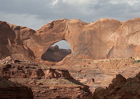
. This rock formation is particularly prominent in southern Utah, where it forms the main attractions of a number of national parks and monuments including Zion National Park
Zion National Park
Zion National Park is located in the Southwestern United States, near Springdale, Utah. A prominent feature of the park is Zion Canyon, which is 15 miles long and up to half a mile deep, cut through the reddish and tan-colored Navajo Sandstone by the North Fork of the Virgin River...
, Capitol Reef National Park
Capitol Reef National Park
Capitol Reef National Park is a United States National Park, in south-central Utah. It is 100 miles long but fairly narrow. The park, established in 1971, preserves 378 mi² and is open all year, although May through September are the most popular months.Called "Wayne Wonderland" in the 1920s...
, Glen Canyon National Recreation Area
Glen Canyon National Recreation Area
Glen Canyon National Recreation Area is a recreation and conservation unit of the National Park Service that encompasses the area around Lake Powell and lower Cataract Canyon in Utah and Arizona, covering 1,254,429 acres of mostly desert...
, Grand Staircase-Escalante National Monument
Grand Staircase-Escalante National Monument
The Grand Staircase-Escalante National Monument contains 1.9 million acres of land in southern Utah, the United States. There are three main regions: the Grand Staircase, the Kaiparowits Plateau, and the Canyons of the Escalante. President Bill Clinton designated the area as a U.S. National...
, and Canyonlands National Park
Canyonlands National Park
Canyonlands National Park is a U.S. National Park located in southeastern Utah near the town of Moab and preserves a colorful landscape eroded into countless canyons, mesas and buttes by the Colorado River, the Green River, and their respective tributaries. The park is divided into four districts:...
. Navajo Sandstone frequently occurs above the Kayenta Formation
Kayenta Formation
The Kayenta Formation is a geologic layer in the Glen Canyon Group that is spread across the Colorado Plateau province of the United States, including northern Arizona, northwest Colorado, Nevada, and Utah. This rock formation is particularly prominent in southeastern Utah, where it is seen in the...
and Wingate Sandstone
Wingate Sandstone
Wingate Sandstone is a geologic formation in the Glen Canyon Group that is spread across the Colorado Plateau province of the United States, including northern Arizona, northwest Colorado, Nevada, and Utah. This rock formation is particularly prominent in southeastern Utah, where it forms...
, the other formations of the Glen Canyon Group. Together, these three formations can result in immense vertical cliffs of up to 2200 feet (670.6 m). Atop the cliffs, Navajo Sandstone often appears as massive rounded domes and bluffs that are generally white in color.
Appearance and provenance
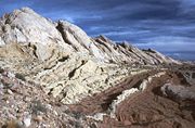
Navajo Sandstone frequently occurs as spectacular cliffs, cuestaCuesta
In structural geology and geomorphology, a cuesta is a ridge formed by gently tilted sedimentary rock strata in a homoclinal structure. Cuestas have a steep slope, where the rock layers are exposed on their edges, called an escarpment or, if more steep, a cliff...
s, domes, and bluffs rising from the desert floor. It can be distinguished from adjacent Jurassic sandstones by its white to light pink color, meter-scale cross-bedding
Cross-bedding
In geology, the sedimentary structures known as cross-bedding refer to horizontal units that are internally composed of inclined layers. This is a case in geology in which the original depositional layering is tilted, and the tilting is not a result of post-depositional deformation...
, and distinctive rounded weathering.
The wide range of colors exhibited by the Navajo Sandstone reflect a long history of alteration by groundwater and other subsurface fluids over the last 190 million years. The different colors, except for white, are caused by the presence of varying mixtures and amounts of hematite
Hematite
Hematite, also spelled as haematite, is the mineral form of iron oxide , one of several iron oxides. Hematite crystallizes in the rhombohedral system, and it has the same crystal structure as ilmenite and corundum...
, goethite
Goethite
Goethite , named after the German polymath Johann Wolfgang von Goethe, is an iron bearing oxide mineral found in soil and other low-temperature environments. Goethite has been well known since prehistoric times for its use as a pigment. Evidence has been found of its use in paint pigment samples...
, and limonite
Limonite
Limonite is an ore consisting in a mixture of hydrated iron oxide-hydroxide of varying composition. The generic formula is frequently written as FeO·nH2O, although this is not entirely accurate as limonite often contains a varying amount of oxide compared to hydroxide.Together with hematite, it has...
filling the pore space within the quartz sand comprising the Navajo Sandstone. The iron in these strata originally arrived via the erosion of iron-bearing silicate
Silicate
A silicate is a compound containing a silicon bearing anion. The great majority of silicates are oxides, but hexafluorosilicate and other anions are also included. This article focuses mainly on the Si-O anions. Silicates comprise the majority of the earth's crust, as well as the other...
minerals. Initially, this iron accumulated as iron-oxide coatings, which formed slowly after the sand had been deposited. Later, after having been deeply buried, reducing fluids composed of water and hydrocarbons flowed through the thick red sand which once comprised the Navajo Sandstone. The dissolution of the iron coatings by the reducing fluids bleached large volumes of the Navajo Sandstone a brilliant white. Reducing fluids transported the iron in solution until they mixed with oxidizing groundwater. Where the oxidizing and reducing fluids mixed, the iron precipitated within the Navajo Sandstone. Depending on local variations within the permeability, porosity, fracturing, and other inherent rock properties of the sandstone, varying mixtures of hematite, goethite, and limonite precipitated within spaces between quartz grains. Variations in the type and proportions of precipitated iron oxides resulted in the different crimson, vermillion, orange, salmon, peach, pink, gold, and yellow colors of the Navajo Sandstone. The precipitation of iron oxides also formed laminea, corrugated layers, columns, and pipes of ironstone within the Navajo Sandstone. Being harder and more resistant to erosion than the surrounding sandstone, the ironstone weathered out as ledges, walls, fins, "flags", towers, and other minor features, which stick out and above the local landscape in unusual shapes.
Age and history of investigation
The age of the Navajo Sandstone is somewhat controversial. It may originate from the Late TriassicLate Triassic
The Late Triassic is in the geologic timescale the third and final of three epochs of the Triassic period. The corresponding series is known as the Upper Triassic. In the past it was sometimes called the Keuper, after a German lithostratigraphic group that has a roughly corresponding age...
but is at least as old as the Early Jurassic
Early Jurassic
The Early Jurassic epoch is the earliest of three epochs of the Jurassic period...
stages Pliensbachian
Pliensbachian
The Pliensbachian is an age of the geologic timescale or stage in the stratigraphic column. It is part of the Early or Lower Jurassic epoch or series and spans the time between 189.6 ± 1.5 Ma and 183 ± 1.5 Ma . The Pliensbachian is preceded by the Sinemurian and followed by the Toarcian.The...
and Toarcian
Toarcian
The Toarcian is, in the ICS' geologic timescale, an age or stage in the Early or Lower Jurassic. It spans the time between 183.0 Ma and 175.6 Ma...
. There is no type locality
Type locality (geology)
Type locality , also called type area or type locale, is the where a particular rock type, stratigraphic unit, fossil or mineral species is first identified....
of the name. It was simply named for the 'Navajo Country'
Navajo people
The Navajo of the Southwestern United States are the largest single federally recognized tribe of the United States of America. The Navajo Nation has 300,048 enrolled tribal members. The Navajo Nation constitutes an independent governmental body which manages the Navajo Indian reservation in the...
of the southwestern United States
Southwestern United States
The Southwestern United States is a region defined in different ways by different sources. Broad definitions include nearly a quarter of the United States, including Arizona, California, Colorado, Nevada, New Mexico, Oklahoma, Texas and Utah...
. The two major subunits of the Navajo are the Lamb Point Tongue (Cedar City area) and the Shurtz Sandstone Tongue (Kanab area).
The Navajo Sandstone was originally named as the uppermost formation of the La Plata Group by Gregory and Stone in 1917. Baker reassigned it as the upper formation of Glen Canyon Group in 1936. Its age was modified by Lewis and others in 1961. The name was originally not used in northwest Colorado and northeast Utah, where the name 'Glen Canyon Sandstone' was preferred. Its age was modified again by Padian in 1989.
Depositonal environment
The sandstoneSandstone
Sandstone is a sedimentary rock composed mainly of sand-sized minerals or rock grains.Most sandstone is composed of quartz and/or feldspar because these are the most common minerals in the Earth's crust. Like sand, sandstone may be any colour, but the most common colours are tan, brown, yellow,...
was deposited in an arid erg on the Western portion of the Supercontinent Pangea
Pangaea
Pangaea, Pangæa, or Pangea is hypothesized as a supercontinent that existed during the Paleozoic and Mesozoic eras about 250 million years ago, before the component continents were separated into their current configuration....
. This region was affected by annual monsoons that came about each winter when cooler winds and wind reversal occurred.
Places found
Navajo Sandstone outcrops are found in these geologic locations:- Colorado PlateauColorado PlateauThe Colorado Plateau, also called the Colorado Plateau Province, is a physiographic region of the Intermontane Plateaus, roughly centered on the Four Corners region of the southwestern United States. The province covers an area of 337,000 km2 within western Colorado, northwestern New Mexico,...
- Black Mesa Basin
- Great BasinGreat BasinThe Great Basin is the largest area of contiguous endorheic watersheds in North America and is noted for its arid conditions and Basin and Range topography that varies from the North American low point at Badwater Basin to the highest point of the contiguous United States, less than away at the...
province - Paradox BasinParadox BasinThe Paradox Basin is an asymmetric foreland basin located mostly in southeast Utah and southwest Colorado, but extending into northeast Arizona and northwest New Mexico. The basin is a large elongate northwest to southeast oriented depression formed during the late Paleozoic Era...
- Piceance BasinPiceance BasinThe Piceance Basin is a geologic structural basin in northwestern Colorado, in the United States. It includes geologic formations from Cambrian to Holocene in age, but the thickest section is made up of rocks from the Cretaceous Period...
- Plateau sedimentary province
- San Juan BasinSan Juan BasinThe San Juan Basin is a geologic structural basin in the Four Corners region of the Southwestern United States; its main portion covers around , encompassing much of northwestern New Mexico, southwest Colorado, and parts of Arizona and Utah....
- Uinta Basin
- Uinta Uplift
- Uncompaghre Uplift
The formation is also found in these parklands (incomplete list):
- Glen Canyon National Recreation AreaGlen Canyon National Recreation AreaGlen Canyon National Recreation Area is a recreation and conservation unit of the National Park Service that encompasses the area around Lake Powell and lower Cataract Canyon in Utah and Arizona, covering 1,254,429 acres of mostly desert...
- Grand Staircase-Escalante National MonumentGrand Staircase-Escalante National MonumentThe Grand Staircase-Escalante National Monument contains 1.9 million acres of land in southern Utah, the United States. There are three main regions: the Grand Staircase, the Kaiparowits Plateau, and the Canyons of the Escalante. President Bill Clinton designated the area as a U.S. National...
- Zion National ParkZion National ParkZion National Park is located in the Southwestern United States, near Springdale, Utah. A prominent feature of the park is Zion Canyon, which is 15 miles long and up to half a mile deep, cut through the reddish and tan-colored Navajo Sandstone by the North Fork of the Virgin River...
- Canyonlands National ParkCanyonlands National ParkCanyonlands National Park is a U.S. National Park located in southeastern Utah near the town of Moab and preserves a colorful landscape eroded into countless canyons, mesas and buttes by the Colorado River, the Green River, and their respective tributaries. The park is divided into four districts:...
- Capitol Reef National ParkCapitol Reef National ParkCapitol Reef National Park is a United States National Park, in south-central Utah. It is 100 miles long but fairly narrow. The park, established in 1971, preserves 378 mi² and is open all year, although May through September are the most popular months.Called "Wayne Wonderland" in the 1920s...
- Arches National ParkArches National ParkArches National Park is a U.S. National Park in eastern Utah. It is known for preserving over 2000 natural sandstone arches, including the world-famous Delicate Arch, in addition to a variety of unique geological resources and formations....
- Dinosaur National MonumentDinosaur National MonumentDinosaur National Monument is a National Monument located on the southeast flank of the Uinta Mountains on the border between Colorado and Utah at the confluence of the Green and Yampa Rivers. Although most of the monument area is in Moffat County, Colorado, the Dinosaur Quarry is located in Utah...
- Colorado National MonumentColorado National Monument- Trails :The Monument contains many hiking trails, with lengths and difficulties to suit all tastes. Summer storms can cause flash floods as well as dangerous trail conditions. Rattlesnakes are found on the Monument, and rough terrain exists everywhere, but most trails are well-maintained...
Ornithodires
Indeterminate theropod remains geographically located in Arizona, USA. Theropod tracks are geographically located in Arizona, Colorado, and Utah, USA. Ornithischian tracks located in Arizona, USA.| Ornithodires of the Navajo Sandstone | ||||||
|---|---|---|---|---|---|---|
| Genus | Species | Location | Stratigraphic position | Material | Notes | Images |
Ammosaurus Ammosaurus Ammosaurus is a genus of sauropodomorph dinosaur from the Early and Middle Jurassic Period of North America. At 4 meters in length, it was small compared to some other members of its suborder, which included the largest animals ever to walk the Earth... |
Ammosaurus cf. major |
|
 |
|||
Pteraichnus Pteraichnus Pteraichnus is an ichnogenus that has been attributed to pterosaurs. It has been found in, among other units, the Lower Jurassic Aztec Sandstone.... |
||||||
Segisaurus Segisaurus Segisaurus is a genus of small coelophysoid theropod dinosaur, that measured approximately 1 metre in length. The only known specimen was discovered in 1933 in early Jurassic strata in Tsegi Canyon, Arizona, for which it was named. Segisaurus is the only dinosaur to have ever been excavated from... |
S. halli |
|
"Partial postcranial skeleton." |
|||
Seitaad Seitaad Seitaad is a genus of sauropodomorph dinosaur which lived during the lower Jurassic period in what is now southern Utah, USA.Seitaad is known from an articulated partial postcranial holotype skeleton referred to as UMNH VP 18040. The skeleton is missing its head, neck and tail... |
S. ruessi |
|
||||
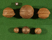
Iron oxide concretions (Moqui marbles)
Iron oxide
Iron oxides are chemical compounds composed of iron and oxygen. All together, there are sixteen known iron oxides and oxyhydroxides.Iron oxides and oxide-hydroxides are widespread in nature, play an important role in many geological and biological processes, and are widely utilized by humans, e.g.,...
concretion
Concretion
A concretion is a volume of sedimentary rock in which a mineral cement fills the porosity . Concretions are often ovoid or spherical in shape, although irregular shapes also occur. The word 'concretion' is derived from the Latin con meaning 'together' and crescere meaning 'to grow'...
s. They are believed to represent an extension of Hopi
Hopi
The Hopi are a federally recognized tribe of indigenous Native American people, who primarily live on the Hopi Reservation in northeastern Arizona. The Hopi area according to the 2000 census has a population of 6,946 people. Their Hopi language is one of the 30 of the Uto-Aztecan language...
Native American traditions regarding ancestor worship ("moqui" translates to "the dead" in the Hopi language). Informally, they are called "Moqui marbles" after the local proposed Moqui native American tribe. Thousands of these concretions weather out of outcrops of the Navajo Sandstone within south-central and southeastern Utah within an area extending from Zion National Park eastward to Arches and Canyonland national parks. They are quite abundant within Grand Staircase-Escalante National Monument.
The iron oxide concretions found in the Navajo Sandstone exhibit a wide variety of sizes and shapes. Their shape ranges from spheres to discs; buttons; spiked balls; cylindrical hollow pipe-like forms; and other odd shapes. Although many of these concretions are fused together like soap bubbles, many more also occur as isolated concretions, which range in diameter from the size of peas to baseballs. The surface of these spherical concretions can range from being very rough to quite smooth. Some of the concretions are grooved spheres with ridges around their circumference.
The abundant concretions found in the Navajo Sandstone consist of sandstone cemented together by hematite
Hematite
Hematite, also spelled as haematite, is the mineral form of iron oxide , one of several iron oxides. Hematite crystallizes in the rhombohedral system, and it has the same crystal structure as ilmenite and corundum...
(Fe2O3), and goethite
Goethite
Goethite , named after the German polymath Johann Wolfgang von Goethe, is an iron bearing oxide mineral found in soil and other low-temperature environments. Goethite has been well known since prehistoric times for its use as a pigment. Evidence has been found of its use in paint pigment samples...
(FeOOH). The iron forming these concretions came from the breakdown of iron-bearing silicate minerals
Silicate minerals
The silicate minerals make up the largest and most important class of rock-forming minerals, constituting approximately 90 percent of the crust of the Earth. They are classified based on the structure of their silicate group...
by weathering to form iron oxide coatings on other grains. During later diagenesis
Diagenesis
In geology and oceanography, diagenesis is any chemical, physical, or biological change undergone by a sediment after its initial deposition and during and after its lithification, exclusive of surface alteration and metamorphism. These changes happen at relatively low temperatures and pressures...
of the Navajo Sandstone while deeply buried, reducing fluids
Redox
Redox reactions describe all chemical reactions in which atoms have their oxidation state changed....
, likely hydrocarbons, dissolved these coatings. When the reducing fluids containing dissolved iron mixed with oxidizing groundwater
Groundwater
Groundwater is water located beneath the ground surface in soil pore spaces and in the fractures of rock formations. A unit of rock or an unconsolidated deposit is called an aquifer when it can yield a usable quantity of water. The depth at which soil pore spaces or fractures and voids in rock...
, they and the dissolved iron were oxidized. This caused the iron to precipitate out as hematite and goethite to form the innumerable concretions found in the Navajo Sandstone. These concretions are regarded as terrestrial analogues of the hematite spherules, called alternately Martian "blueberries" or more technically Martian spherules
Martian spherules
Martian spherules are the abundant spherical hematite inclusions discovered by the Mars rover Opportunity at Meridiani Planum on the planet Mars...
, which the Opportunity rover
Opportunity rover
Opportunity, MER-B , is a robotic rover on the planet Mars, active since 2004. It is the remaining rover in NASA's ongoing Mars Exploration Rover Mission...
found at Meridiani Planum
Meridiani Planum
Meridiani Planum is a plain located 2 degrees south of Mars' equator , in the westernmost portion of Terra Meridiani. It hosts a rare occurrence of gray crystalline hematite...
on Mars
Mars
Mars is the fourth planet from the Sun in the Solar System. The planet is named after the Roman god of war, Mars. It is often described as the "Red Planet", as the iron oxide prevalent on its surface gives it a reddish appearance...
.
Works cited
- Averitt, P., Wilson, R.F., Detterman, J.S., Harshbarger, J.W. and Repenning, C.A., 1955, "Revisions in correlation and nomenclature of Triassic and Jurassic formations in southwestern Utah and northern Arizona", American Association of Petroleum Geologists Bulletin, v. 39, no. 12, p. 2515–2524
- Baker, A.A., 1936, "Geology of the Monument Valley-Navajo Mountain region, San Juan County, Utah", U.S. Geological Survey Bulletin 865, 106 p., Also, U.S. Geological Survey Oil and Gas Investigations Map OM-168, and Bulletin 1087-D.
- Gregory, H.E. and Stone, R.W., 1917, "Geology of the Navajo country; a reconnaissance of parts of Arizona, New Mexico, and Utah", U.S. Geological Survey Professional Paper, 93, 161 p.
- Chan, M.A. and W.T. Parry, 2002, Mysteries of Sandstone Colors and Concretions in Colorado Plateau Canyon Country PDF version, 468 KB Utah Geological Survey Public Information Series 77:1-19.
- Chan, M.A., B.B. Beitler, W.T. Parry, J. Ormo, and G. Komatsu, 2005. Red Rock and Red Planet Diagenesis: Comparison of Earth and Mars Concretions PDF version, 3.4 MB. GSA Today, v. 15, n. 8, pp. 4–10.
- Lewis, G.E., Irwin, J.H. and Wilson, R.F., 1961, "Age of the Glen Canyon Group (Triassic and Jurassic) on the Colorado Plateau", Geological Society of America Bulletin v. 72, no. 9, p. 1437–1440
- Padian, K., 1989, "Presence of dinosaur Scelidosaurus indicates Jurassic age for the Kayenta Formation (Glen Canyon Group, northern Arizona)", Geological Society of America, Geology, v. 17, no. 5, p. 438-441
- Poole, F.G. and Stewart, J.H., 1964, "Chinle Formation and Glen Canyon Sandstone in northeastern Utah and northwestern Colorado, IN Geological Survey research 1964", U.S. Geological Survey Professional Paper, 501-D, p. D30-D39
- USGS: Colorado River Basin Stratigraphy - Navajo Sandstone Accessed 18 March 2006 (public domain text)
- Weishampel, David B.; Dodson, Peter; and Osmólska, Halszka (eds.): The Dinosauria, 2nd, Berkeley: University of California Press. 861 pp. ISBN 0-520-24209-2.
- Loope, D. B. and Rowe, C.M., 2003, long‐lived pluvial episodes during deposition of the Navajo Sandstone: The Journal of Geology, v. 111, p. 223-232.
Internet - general
- U.S.G.S Lexicon of Colorado Plateau Stratigraphy
- Spatial Distribution in Macrostrat
- Avalanche Segregation and Stratification
- Eolian Pin Stripes in the Navajo Sandstone
- Navajo Sandstone Fossils
- Burrows and Vertebrate Tracks in the Navajo Sandstone
- Dry-Season Dinosaur Tracks in the Navajo Sandstone PDF Version (3.9 MB) of GSA poster
- Navajo Sandstone
- Jurassic Rain on the Navajo Desert
- Jurassic monsoons
- Tracing the Navajo sandstone
- Navajo Moqui Marbles and Martian Blueberries
- Bleaching of Jurassic Navajo Sandstone
Scientific publications
- Chan, M.A., and A.W. Archer, 2000, Cyclic Eolian Stratification on the Jurassic Navajo Sandstone, Zion National Park: Periodicities and Implications for Paleoclimate PDF version, 3.2 MB. in D.A. Sprinkel, T.C. Chidsey, Jr., and P.B. Anderson, eds., Geology of Utah's Parks and Monuments. Utah Geological Association Publication 28:1-11.
- Kocurek G. 2003. Limits on extreme Eolian systems: Sahara of Mauritania and Jurassic Navajo Sandstone examples. in M. Chan and A. Archer, eds., Extreme Depositional Environments: Mega End Members in Geologic Time. Geological Society of America Special Paper 370:43-52.
- Loope, D.B., and C.M. Rowe, 2003, Long-Lived Pluvial Episodes during Deposition of the Navajo Sandstone PDF version, 1.3 MB. The Journal of Geology 111:223-232.
- Loope, D.B., and C.M. Rowe, 2005, Seasonal Patterns of wind and rain recorded by the Navajo Sandstone PDF version, 7.4 MB. Canyon Legacy. 54:8-12.
- Loope, D., L. Eisenberg, and E. Waiss, 2004, Navajo sand sea of near-equatorial Pangea: Tropical westerlies, slumps, and giant stromatolites PDF version, 9.1 MB. in E.P. Nelson and E.A. Erslev, eds., Field Trips in the Southern Rocky Mountains, USA. Geological Society of America Field Guide 5:1-13.
- Loope, D.B., C.M. Rowe, and R.M. Joeckel, 2001, Annual monsoon rains recorded by Jurassic dunes PDF version, 284 KB. Nature. 412:64-66.
- Loope, D.B., M.B. Steiner, C.M. Rowe, and N. Lancaster, 2004, Tropical westerlies over Pangean sand seas PDF version, 340 KB. Sedimentology. 51:315-322.
- Rainforth, E.C., 1997, Vertebrate ichnological diversity and census studies, Lower Jurassic Navajo Sandstone PDF version, 3.9 MB. Unpublished masters thesis, Department of Geological Sciences, University of Colorado, Boulder.
- Tape, C., 2004, Cross-bedding in the Navajo Sandstone and implications for paleoclimate forcing, Zion national Park Site PDF version, 4.7 MB. in J.L. Kirschvink, ed., Field Trip to Colorado Plateau (southern Utah, northern Arizona, Permian-Triassic boundary). Division of Geological and Planetary Sciences, California Institute of Technology, University of California.
- Tape, C., 2005, The Lower Jurassic Navajo Sandstone: large-scale deposition and small-scale structures, Site: Glen Canyon Dam PDF version, 4.8 MB. in J.L. Kirschvink, ed., Field Trip to Colorado Plateau (southern Utah, northern Arizona, Permian-Triassic boundary). Division of Geological and Planetary Sciences, California Institute of Technology, University of California.