
Murray River crossings
Encyclopedia
The Murray River
in south-eastern Australia
has been a significant barrier to land-based travel and trade. This article lists and briefly describes all of the recognised crossing points. Many of these had also developed as river ports for transport of goods along the Murray. Now almost every significant town along the river has a bridge
or vehicle-carrying cable ferry
nearby.
The crossings are listed in order starting from the Murray Mouth
and proceeding upstream.
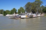
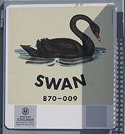 As the ferries are registered as boats, each one has a name, usually named after a waterbird. As of August 2010, the ferry names are:
In Victoria
The south bank of the river forms the border between these two states and former colonies, so in many cases there is a town on each side of the river. If two towns are named in this list, the Victorian one is first for clarity and consistency.
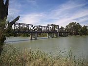
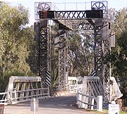
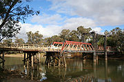
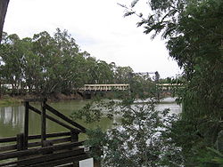
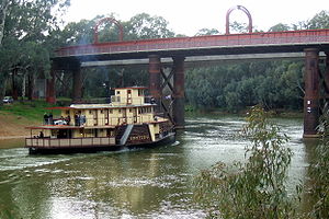
Most of the bridges downstream of Echuca are liftspan bridges to enable paddlesteamer traffic to pass underneath even in times of high water flow.
The Hume
, Newell
and Sturt Highway
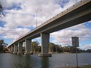
bridges are owned and managed by the Federal Government. The others are the responsibility of New South Wales and Victoria.
Murray River
The Murray River is Australia's longest river. At in length, the Murray rises in the Australian Alps, draining the western side of Australia's highest mountains and, for most of its length, meanders across Australia's inland plains, forming the border between New South Wales and Victoria as it...
in south-eastern Australia
Australia
Australia , officially the Commonwealth of Australia, is a country in the Southern Hemisphere comprising the mainland of the Australian continent, the island of Tasmania, and numerous smaller islands in the Indian and Pacific Oceans. It is the world's sixth-largest country by total area...
has been a significant barrier to land-based travel and trade. This article lists and briefly describes all of the recognised crossing points. Many of these had also developed as river ports for transport of goods along the Murray. Now almost every significant town along the river has a bridge
Bridge
A bridge is a structure built to span physical obstacles such as a body of water, valley, or road, for the purpose of providing passage over the obstacle...
or vehicle-carrying cable ferry
Cable ferry
A cable ferry is guided and in many cases propelled across a river or other larger body of water by cables connected to both shores. They are also called chain ferries, floating bridges, or punts....
nearby.
The crossings are listed in order starting from the Murray Mouth
Murray Mouth
Murray Mouth is the point at which the River Murray meets the southern Southern Ocean. The Murray Mouth's location is changeable. Historical records show that the channel out to sea moves along the sand dunes over time...
and proceeding upstream.
South Australia
| Image | Crossing | Coordinates | Location | Built | Description | Notes |
|---|---|---|---|---|---|---|
 |
Hindmarsh Island Bridge | 35°30′17"S 138°47′21"E | Hindmarsh Island Hindmarsh Island Hindmarsh Island is an island in the lower Murray River near the town of Goolwa, South Australia. Located on the Fleurieu Peninsula, it is a popular tourist destination, which has increased in popularity since the Hindmarsh Island bridge was opened in 2001... -Goolwa Goolwa, South Australia Goolwa is a historic river port on the Murray River near the Murray Mouth in South Australia, and joined by a bridge to Hindmarsh Island. The name "Goolwa" means "elbow" in Ngarrindjeri, the local Aboriginal language.... |
2001 | The controversial bridge Hindmarsh Island bridge controversy The Hindmarsh Island bridge controversy was a 1990s Australian legal and political controversy that involved the clash of Indigenous Australian religious beliefs and property rights... replaced a ferry in March 2001 |
|
| Narrung Ferry | 35°30′46"S 139°11′17"E | Narrung Narrung, South Australia Narrung is a settlement in South Australia. It is situated at the northern extent of the Narrung Peninsula, which separates The Coorong from Lake Albert adjacent to The Narrows which separates Lake Albert from the larger Lake Alexandrina.... |
crosses The Narrows between Lake Alexandrina and Lake Albert | |||
| Wellington Ferry | 35°19′51"S 139°23′8"E | Wellington Wellington, South Australia Wellington is the small town in South Australia on the Murray River just upstream of where it empties into Lake Alexandrina. Its postcode is 5259. Wellington is in the Rural City of Murray Bridge... |
||||
| Tailem Bend Ferry | 35°15′26"S 139°27′8"E | Tailem Bend Tailem Bend, South Australia Tailem Bend is a town on the Murray River in South Australia. The town was proclaimed in 1887, the year after the main railway came through. At the 2006 census, Tailem Bend had a population of 1,457.... -Jervois Jervois, South Australia Jervois is a town in South Australia. The town is located in the Rural City of Murray Bridge local government area, south of the state capital, Adelaide and on the opposite bank of the River Murray from nearby Tailem Bend. At the 2006 census, Jervois and the surrounding area had a population of 283.... |
||||
 |
Swanport Bridge Swanport Bridge Swanport Bridge is a road bridge on Highway 1 in South Australia, spanning the Murray River approximately 4 km southeast of Murray Bridge. Constructed in 1979, the bridge connects the communities of Murray Bridge and Tailem Bend.-Characteristics:... |
35°08′51"S 139°18′33"E | Murray Bridge Murray Bridge, South Australia Murray Bridge is the fourth most populous city in South Australia after Adelaide, Mount Gambier and Whyalla. It is located east-southeast of Adelaide and north of Meningie.... |
1979 | At the end of the South Eastern Freeway South Eastern Freeway The South Eastern Freeway is a 66 kilometre four-lane divided carriageway road in South Australia linking the Adelaide-Crafers Highway to the Princes Highway at the Swanport Bridge, a one kilometre long bridge over the River Murray, near Murray Bridge... |
|
| Murray Bridge | 35°06′55"S 139°16′48"E | Murray Bridge Murray Bridge, South Australia Murray Bridge is the fourth most populous city in South Australia after Adelaide, Mount Gambier and Whyalla. It is located east-southeast of Adelaide and north of Meningie.... |
1927 (rail) 1879 (road) | Two bridges, side by side | ||
 |
Mannum Ferry | 34°54′37"S 139°19′7"E | Mannum Mannum, South Australia Mannum is an historic town on the west bank of the Murray River in South Australia, east of Adelaide. At the 2006 census, Mannum had a population of 2,042. Mannum headquarters the Mid Murray Council, and is situated in both the State Electoral District of Schubert and the federal Division of... |
Two parallel ferries | ||
| Purnong Ferry | 34°51′17"S 139°37′0"E | Purnong | This is the narrowest crossing in South Australia | |||
| Walker Flat Ferry | 34°45′13"S 139°34′8"E | | Walker Flat | ||||
| Swan Reach Ferry | 34°33′51"S 139°35′50"E | Swan Reach Swan Reach, South Australia Swan Reach is a river port in South Australia located 127 km north east of Adelaide on the Murray River between Blanchetown and Mannum in South Australia. It is on the left bank of the river. The Swan Reach Ferry is a cable ferry crossing operated by the state government as part of the... |
||||
| Blanchetown Bridge | 34°20′43"S 139°37′2"E | Blanchetown Blanchetown, South Australia Blanchetown is a small township in South Australia, on the bank of the Murray River, 130 km northeast of Adelaide. The Blanchetown Bridge is the western-most of the four crossings of the Sturt Highway over the Murray River. During the nineteenth century it was an important... |
1963 | The original bridge was constructed in 1963 on the Sturt Highway Sturt Highway The Sturt Highway is an Australian highway in New South Wales, Victoria, and South Australia. It is part of the Auslink National network and is part of the main highway route between Sydney and Adelaide.-Route:... . there had been a ferry crossing since 1869. It was the first major prestressed concrete highway bridge in South Australia. In the 1990s it was found to not be structurally sound enough to safely carry B-double Semi-trailer A semi-trailer is a trailer without a front axle. A large proportion of its weight is supported by a road tractor, a detachable front axle assembly known as a dolly, or the tail of another trailer... trucks. Until a new bridge could be built, these were diverted from near Monash Monash, South Australia Monash is a town in the Riverland area of South Australia. It is on the Sturt Highway between Barmera and Renmark. At the 2006 census, Monash had a population of 1,115.... via Morgan Morgan, South Australia Morgan is a town in South Australia on the right bank of the Murray River, just downstream of where it turns from flowing roughly westwards to roughly southwards. It is about north east of Adelaide, and about upstream of the Murray Mouth. At the 2006 census, Morgan had a population of 426.The... and Eudunda Eudunda, South Australia Eudunda is a rural town in South Australia, roughly 103 kilometres northeast of Adelaide, established in 1870 after settlers began moving into the area in the 1860s... to rejoin the highway at Gawler Gawler, South Australia Gawler is the first country town in the state of South Australia, and is named after the second Governor of the colony of South Australia, George Gawler. It is located north of the centre of the state capital, Adelaide, and is close to the major wine producing district of the Barossa Valley... , thus travelling further but avoiding the Kingston and Blanchetown bridges. |
||
| Morgan Ferry | 34°02′19"S 139°40′24"E | Morgan Morgan, South Australia Morgan is a town in South Australia on the right bank of the Murray River, just downstream of where it turns from flowing roughly westwards to roughly southwards. It is about north east of Adelaide, and about upstream of the Murray Mouth. At the 2006 census, Morgan had a population of 426.The... |
||||
| Cadell Ferry | 34°01′32"S 139°45′45"E | Cadell Cadell, South Australia Cadell is a town situated near the north western edge of South Australia's Riverland on the inside of the large southward bend in the Murray River. The town is named after Captain Francis Cadell, who was the navigator on Charles Sturt's exploration of Murray River... |
||||
| Waikerie Ferry | 34°10′30"S 139°59′13"E | Waikerie Waikerie, South Australia Waikerie is a rural town in the Riverland region of South Australia on the south bank of the Murray River. At the 2006 census, Waikerie had a population of 1,744. The Sturt Highway passes to the south of the town at the top of the cliffs... |
||||
| Kingston on Murray bridge | 34°13′37"S 140°21′59"E | Kingston-on-Murray Kingston-On-Murray, South Australia Kingston-On-Murray is a town on the south bank of the Murray River in the Riverland region of South Australia. It was named after Charles Kingston who was Premier of South Australia from 1893-99. At the 2006 census, the town had a population of 257.... |
1969 | Sturt Highway Sturt Highway The Sturt Highway is an Australian highway in New South Wales, Victoria, and South Australia. It is part of the Auslink National network and is part of the main highway route between Sydney and Adelaide.-Route:... A bridge replaced a ferry |
||
 |
Berri Bridge | 34°17′22"S 140°35′59"E | Berri Berri, South Australia Berri is a town in the Riverland region of South Australia. It is 238 kilometres north-east of Adelaide, the capital of the state of South Australia. It is primarily an agricultural and viticultural town on the north bank of the Murray River... |
1997 | A bridge replaced two ferries | |
| Lyrup Ferry | 34°15′8"S 140°38′54"E | Lyrup Lyrup, South Australia Lyrup is a town in South Australia's rural Riverland area. Lyrup is located on the banks of the Murray River. It is 267 kilometres north-east of Adelaide, the capital of the state of South Australia and 25 kilometres from Renmark. At the 2006 census, Lyrup had a population of 502.Lyrup is... |
||||
 |
Paringa Bridge | 34°10′51"S 140°46′33"E | Paringa Paringa, South Australia Paringa is a small town in the Riverland of South Australia. Paringa is famous for its vineyards, almond, citrus and stone fruit orchards, and the beautiful steel bridge with a span that can be raised to allow houseboats and paddlesteamers to pass underneath. across the Murray River to Renmark.... -Renmark Renmark, South Australia Renmark is a town in South Australia's rural Riverland area, and is located 254 km northeast of Adelaide, on the banks of the River Murray. The Sturt Highway between Adelaide and Sydney runs through the town; Renmark is the last major town encountered in South Australia when driving this route. It... |
1926 | Sturt Highway Sturt Highway The Sturt Highway is an Australian highway in New South Wales, Victoria, and South Australia. It is part of the Auslink National network and is part of the main highway route between Sydney and Adelaide.-Route:... , liftspan bridge - one lane of traffic each way with pedestrian/bike path in the middle on a former railway alignment. |
- Narrung: GullGullGulls are birds in the family Laridae. They are most closely related to the terns and only distantly related to auks, skimmers, and more distantly to the waders...
- Wellington: QuailQuailQuail is a collective name for several genera of mid-sized birds generally considered in the order Galliformes. Old World quail are found in the family Phasianidae, while New World quail are found in the family Odontophoridae...
- Tailem Bend: PloverPloverPlovers are a widely distributed group of wading birds belonging to the subfamily Charadriinae. There are about 40 species in the subfamily, most of them called "plover" or "dotterel". The closely related lapwing subfamily, Vanellinae, comprises another 20-odd species.Plovers are found throughout...
- Mannum large (downstream): SwanSwanSwans, genus Cygnus, are birds of the family Anatidae, which also includes geese and ducks. Swans are grouped with the closely related geese in the subfamily Anserinae where they form the tribe Cygnini. Sometimes, they are considered a distinct subfamily, Cygninae...
- Mannum (small, upstream): SwallowSwallowThe swallows and martins are a group of passerine birds in the family Hirundinidae which are characterised by their adaptation to aerial feeding...
- Purnong: KingfisherKingfisherKingfishers are a group of small to medium sized brightly coloured birds in the order Coraciiformes. They have a cosmopolitan distribution, with most species being found in the Old World and Australia...
- Walker Flat: StiltStiltStilt is a common name for several species of birds in the family Recurvirostridae, which also includes those known as avocets. They are found in brackish or saline wetlands in warm or hot climates....
II - Swan Reach: CootCootCoots are medium-sized water birds that are members of the rail family Rallidae. They constitute the genus Fulica. Coots have predominantly black plumage, and, unlike many of the rails, they are usually easy to see, often swimming in open water...
- Morgan: HeronHeronThe herons are long-legged freshwater and coastal birds in the family Ardeidae. There are 64 recognised species in this family. Some are called "egrets" or "bitterns" instead of "heron"....
- Cadell: IbisIbisThe ibises are a group of long-legged wading birds in the family Threskiornithidae....
- Waikerie: Water HenDusky MoorhenThe Dusky Moorhen is a bird in the rail family. It occurs in Australia, New Guinea, and Indonesia.The New Guinea birds are smaller, at 25-32 cm in length, than the Australian race...
- Lyrup: AvocetAvocetThe four species of Avocets are a genus, Recurvirostra, of waders in the same avian family as the stilts.Avocets have long legs and long, thin, upcurved bills which they sweep from side to side when feeding in the brackish or saline wetlands they prefer...
In VictoriaVictoria (Australia)Victoria is the second most populous state in Australia. Geographically the smallest mainland state, Victoria is bordered by New South Wales, South Australia, and Tasmania on Boundary Islet to the north, west and south respectively....
and New South WalesNew South WalesNew South Wales is a state of :Australia, located in the east of the country. It is bordered by Queensland, Victoria and South Australia to the north, south and west respectively. To the east, the state is bordered by the Tasman Sea, which forms part of the Pacific Ocean. New South Wales...
The south bank of the river forms the border between these two states and former colonies, so in many cases there is a town on each side of the river. If two towns are named in this list, the Victorian one is first for clarity and consistency.Most of the bridges downstream of Echuca are liftspan bridges to enable paddlesteamer traffic to pass underneath even in times of high water flow.
The Hume
Hume Highway
The Hume Highway/Hume Freeway is one of Australia's major inter-city highways, running for 880 km between Sydney and Melbourne. It is part of the Auslink National Network and is a vital link for road freight to transport goods to and from the two cities as well as serving Albury-Wodonga and...
, Newell
Newell Highway
The Newell Highway is the longest highway in New South Wales, Australia. It runs parallel to the eastern coast about 400 kilometres inland, and is the main inland direct road link from Victoria to Queensland, bypassing the more congested coastal areas of New South Wales...
and Sturt Highway
Sturt Highway
The Sturt Highway is an Australian highway in New South Wales, Victoria, and South Australia. It is part of the Auslink National network and is part of the main highway route between Sydney and Adelaide.-Route:...
bridges are owned and managed by the Federal Government. The others are the responsibility of New South Wales and Victoria.
| Image | Crossing | Coordinates | Location | Built | Description | Notes |
|---|---|---|---|---|---|---|
 |
Abbotsford Bridge | 34°06′50"S 141°59′17"E | Yelta Yelta, Victoria Yelta is a small locality in Victoria, Australia. It was for a short time in the 1870s and 1880s the Victorian administrative centre of what is now Sunraysia and the Millewa. This role was then taken over by Mildura... to Curlwaa Curlwaa, New South Wales Curlwaa is a locality in New South Wales, Australia.Curlwaa is an irrigation settlement a few kilometers upstream of Wentworth on the Murray River in far southwestern New South Wales.... |
1928 | 235 metres (771 ft) long, single lane lift bridge | |
 |
George Chaffey bridge | 34°10′59"S 142°10′24"E | Mildura Mildura, Victoria Mildura is a regional city in northwestern Victoria, Australia and seat of the Rural City of Mildura local government area. It is located in the Sunraysia region, and is on the banks of the Murray River. The current population is estimated at just over 30,000.Mildura is a major agricultural centre... to Buronga Buronga, New South Wales Buronga is a town in New South Wales, Australia on the Murray River. The George Chaffey Bridge connects Buronga with Mildura, Victoria. In 2006, the town had a population of 807 people.-Buronga Today:... |
1985 | high arched bridge carrying the Sturt Highway Sturt Highway The Sturt Highway is an Australian highway in New South Wales, Victoria, and South Australia. It is part of the Auslink National network and is part of the main highway route between Sydney and Adelaide.-Route:... , 331 metres (1,086 ft) long, 9.8 metres (32.2 ft) wide |
|
| Robinvale-Euston Bridge | 34°34′40"S 142°46′3"E | Robinvale Robinvale, Victoria Robinvale is a town on the south bank of the Murray River in northern Victoria, Australia. It is connected by a bridge to Euston on the other side of the river in New South Wales. At the 2006 census, Robinvale had a population of 2214.-History:... to Euston Euston, New South Wales Euston is a small town on the banks of the Murray River, southern New South Wales, Australia in Balranald Shire. The twin town of Robinvale is on the other side of the river in the state of Victoria. At the 2006 census, Euston had a population of 462 people. Until the irrigation development at... |
2006 | Replaced a liftspan bridge that was built as part of abandoned railway extension in 1924.http://www.rta.nsw.gov.au/constructionmaintenance/majorconstructionprojectsregional/murrayriverbridges/robinvaleeuston. | ||
 |
Tooleybuc Bridge | 35°01′49"S 143°20′7"E | Piangil Piangil, Victoria Piangil is a remote town in Northern Victoria, Australia. It is approximately north west of Swan Hill. At the 2006 census, Piangil had a population of 654.... to Tooleybuc Tooleybuc, New South Wales Tooleybuc is a town in the western Riverina district of New South Wales, Australia. The town is located on the Mallee Highway, south west of the state capital, Sydney and north west of Melbourne. Situated on the banks of the Murray River across from Piangil in the neighbouring state of... |
1925 | timber and steel truss, single lane restriction on lift span | |
| Nyah Bridge | 35°10′22"S 143°23′30"E | Nyah Nyah, Victoria Nyah is a town in northern Victoria, Australia. The town is located on the Murray Valley Highway, in the Rural City of Swan Hill Local Government Area, 365 kilometres north west of the state capital, Melbourne... to Koraleigh Koraleigh, New South Wales Koraleigh is a small village in the Riverina District of New South Wales, Australia on the Murray River in Wakool Shire. It is situated 6 km northeast from Nyah, Victoria and 15 km south from Tooleybuc. At the 2006 census, Koraleigh had a population of 373 people.Koraleigh Post Office... |
1941 | 104 metres (341.2 ft), central lift span | ||
| Speewa Ferry Speewa Ferry The Speewa Ferry is a cable ferry across the Murray River on the border between the Australian states of New South Wales and Victoria. The ferry is located in the community of Speewa, Victoria, approximately north of Swan Hill, off the road between Swan Hill and Nyah.The ferry is controlled by New... |
35°12′49"S 143°30′31"E | Speewa Speewa, Victoria Speewa is a locality in Victoria, Australia, located approximately 19 km from Swan Hill, Victoria on the Murray River. It is unusual in that it shares its name with a contiguous locality in New South Wales.... |
2-car capacity, 8 tonne (8.8 t) load limit | |||
 |
Swan Hill Bridge | 35°20′16"S 143°33′46"E | Swan Hill Swan Hill, Victoria Swan Hill is a city in the northwest of Victoria, Australia. It is located on the Murray Valley Highway, on the south bank of the Murray River, downstream from the junction of the Loddon River. At the 2006 census, Swan Hill had a population of 9,684.-History:... |
1896 | 2 lanes except central lift span; 116 metres (380.6 ft) | |
| Gonn Crossing Bridge | 35°30′13"S 143°57′24"E | Murrabit Murrabit, Victoria Murrabit is a town in north east Victoria, Australia. The town is located on the Murray River, from the state capital, Melbourne and from Swan Hill... to Ballbank Ballbank, New South Wales Ballbank is an area in the south western part of the Riverina and situated about 5 kilometres north from Murrabit and 28 kilometres north west from Barham.Ballbank used to be a part of the Stony Crossing railway line and lies between Murrabit and Nacurrie... |
1926 | 103 metres (338 ft) | ||
 |
Barham Bridge | 35°37′50"S 144°07′29"E | Koondrook Koondrook, Victoria Koondrook is a town situated on the Murray River, Victoria, Australia. The town is located in the Shire of Gannawarra Local government area, north west of the state capital, Melbourne. At the 2006 census, Koondrook had a population of 802.-History:... to Barham Barham, New South Wales Barham is a town in the western Riverina district of New South Wales, Australia. The town is located 823 kilometres south west of the state capital, Sydney and 303 kilometres north west of Melbourne. Situated on the banks of the Murray River across from Koondrook in the neighbouring state of... |
1904 | liftspan bridge, 99 metres (325 ft) | |
 |
Echuca-Moama Bridge (road) | 36°07′19"S 144°45′13"E | Echuca Echuca, Victoria Echuca is a town located on the banks of the Murray River and Campaspe river in Victoria, Australia. The Border town Moama is on the northern side of the Murray river in New South Wales. It is the administrative centre and largest settlement in the Shire of Campaspe... to Moama Moama, New South Wales Moama is a town in the Riverina district of southern New South Wales, Australia, in the Murray Shire Local Government Area. The town is directly across the Murray River from the larger tourist town of Echuca in the neighbouring state of Victoria, to which it is connected by a bridge... |
1879 | built as joint road/rail bridge, proposed for replacement/bypass | |
| Echuca-Moama Bridge (rail) | 36°07′19"S 144°45′13"E | 1989 | rail | |||
| Barmah Bridge | 36°01′8"S 144°57′19"E | Barmah Barmah, Victoria Barmah is a town in Victoria, with the distinction of being located north of the southerly border with New South Wales. At the 2006 census, Barmah had a population of 201.... |
1966 | 168 metres (551.2 ft) replaced ferry | ||
| Tocumwal Rail Bridge | 35°48′50"S 145°33′24"E | Tocumwal Tocumwal, New South Wales Tocumwal is a town in the southern Riverina region of New South Wales, Australia in the Berrigan Shire Local Government Area, near the Victorian border. The town is situated on the banks of the Murray River, north of the city of Melbourne. The Newell Highway, part of the main road route between... |
1895 | originally a road/rail bridge | ||
| Tocumwal bridge (road) | 35°48′47"S 145°33′32"E | 1987 | Newell Highway Newell Highway The Newell Highway is the longest highway in New South Wales, Australia. It runs parallel to the eastern coast about 400 kilometres inland, and is the main inland direct road link from Victoria to Queensland, bypassing the more congested coastal areas of New South Wales... 212 metres (695.5 ft) long, 12 metres (39.4 ft) wide |
|||
| Cobram-Barooga Bridge (old) | 35°54′57"S 145°40′9"E | Cobram Cobram, Victoria Cobram is a town in Australia. Cobram is located on the Murray River which forms the border between Victoria and New South Wales. Cobram along with the nearby towns of Numurkah and Yarrawonga is part of Shire of Moira. Its twin town of Barooga is located on the north side of the Murray River.... to Barooga Barooga, New South Wales Barooga is a border town in the Riverina region of New South Wales, Australia, situated just north of the Murray River which forms the border withVictoria. It is located in the Berrigan Shire Council Local Government Area... |
1902 | Old liftspan timber truss bridge (now pedestrian only) | ||
| Cobram-Barooga Bridge (new) | 35°54′58"S 145°40′9"E | 2006 | New concrete bridge built immediately upstream of the old bridge | |||
| Yarrawonga Weir Lake Mulwala Lake Mulwala was created in 1939 by building a dam across the Murray River between Yarrawonga in Victoria and Mulwala in New South Wales to provide irrigation water for the surrounding district... |
36°00′31"S 145°59′57"E | Yarrawonga Yarrawonga, Victoria Yarrawonga is a town in the Shire of Moira Local Government Area in the Australian state of Victoria. The town is situated on the south bank of the Murray River, the border between Victoria and New South Wales and is located approximately north-east of the state capital, Melbourne. Yarrawonga's... to Mulwala Mulwala, New South Wales Mulwala is a town in the Corowa Shire Local Government Area in the Riverina district of New South Wales, Australia. The town is situated on Lake Mulwala, an artificial lake formed by the damming of the Murray River. At the 2006 census, Mulwala had a population of 1,986 people... |
1939 | Weir Road, one lane along the weir wall - originally designated as a stock route | ||
| Yarrawonga Rail Bridge | 36°00′29"S 145°59′59"E | 1989 | railway bridge Oaklands railway line, Victoria The Oaklands railway line is a freight only railway line in north eastern Victoria, Australia. The line branches from the main North East railway at Benalla station until it connects with the New South Wales railway network at Oaklands, New South Wales.... , replaced earlier wooden bridge and earthen embankment |
|||
| Mulwala Bridge Mulwala Bridge Mulwala Bridge is a bridge crossing Lake Mulwala, formed by a weir on the Murray River in Australia. The bridge links the border towns of Yarrawonga, Victoria and Mulwala, New South Wales. The bridge was built in 1924 and designed by Percy Allan using a Pratt truss.-References:... |
36°00′20"S 146°00′18"E | 1924 | Crosses Lake Mulwala Lake Mulwala Lake Mulwala was created in 1939 by building a dam across the Murray River between Yarrawonga in Victoria and Mulwala in New South Wales to provide irrigation water for the surrounding district... , 488 metres (1,601 ft) |
|||
| John Foord Bridge | 36°00′25"S 146°23′43"E | Wahgunyah Wahgunyah, Victoria Wahgunyah is a small town in northeastern Victoria, Australia. It is located on the southern bank of the Murray River, opposite Corowa, New South Wales. Wahgunyah is approximately north of Rutherglen and west of Albury and Wodonga. At the 2006 census, Wahgunyah had a population of 809... to Corowa Corowa, New South Wales Corowa is a town in the state of New South Wales in Australia. It is on the bank of the Murray River, the border between New South Wales and Victoria, opposite the Victorian town of Wahgunyah. Corowa is the administrative centre of Corowa Shire... |
1892 | retained for local traffic | ||
| Federation Bridge | 35°59′8"S 146°24′40"E | 2005 | Two lanes wide and 195 metres (639.8 ft) long, with a 95 metres (311.7 ft) approach bridge on the NSW side. http://www.rta.nsw.gov.au/constructionmaintenance/majorconstructionprojectsregional/murrayriverbridges/corowabridge/index.html | |||
| John Conway Bourke Bridge | 35°59′37"S 146°37′15"E | Howlong Howlong, New South Wales Howlong is a town west of Albury, and is situated on the Murray River which separates the Australian states of New South Wales and Victoria. The town is located on the Riverina Highway. There is a bridge across the Murray into Victoria. Howlong is in the Corowa Shire Local government area... |
2001 | |||
| Lincoln Causeway/Union Bridge | 36°6′33"S 146°53′59"E | Wodonga Wodonga, Victoria Wodonga is a small city on the Victorian side of the border with New South Wales, north-east of Melbourne, Australia. Adjacent to Wodonga across the border is the New South Wales city of Albury. Wodonga is located wholly within the boundaries of the City of Wodonga LGA... to Albury Albury, New South Wales Albury is a major regional city in New South Wales, Australia, located on the Hume Highway on the northern side of the Murray River. It is located wholly within the boundaries of the City of Albury Local Government Area... |
1961 | 4 lanes, 92 metres (301.8 ft) long, widened 1990 | ||
| Albury/Wodonga Rail Bridge | 36°6′29"S 146°53′59"E | 1888 | double track Double track A double track railway usually involves running one track in each direction, compared to a single track railway where trains in both directions share the same track.- Overview :... - one Broad gauge Broad gauge Broad-gauge railways use a track gauge greater than the standard gauge of .- List :For list see: List of broad gauges, by gauge and country- History :... plus one Standard gauge Standard gauge The standard gauge is a widely-used track gauge . Approximately 60% of the world's existing railway lines are built to this gauge... |
|||
| Spirit of Progress Bridge | 36°6′33"S 146°53′37"E | 2006 | New Hume Highway Hume Highway The Hume Highway/Hume Freeway is one of Australia's major inter-city highways, running for 880 km between Sydney and Melbourne. It is part of the Auslink National Network and is a vital link for road freight to transport goods to and from the two cities as well as serving Albury-Wodonga and... bridge, named for the former Spirit of Progress Spirit of Progress The Spirit of Progress was the premier express train passenger service on the Victorian Railways in Australia, running from Melbourne to the Victorian border, and later through to Sydney.-Route:... train. |
|||
| Heywood Bridge | 36°05′57"S 147°01′19"E | Hume Dam to Bonegilla Bonegilla, Victoria Bonegilla is a bounded rural locality of the City of Wodonga Local Government Area in northeast Victoria, Australia, located 10 kilometres east of Wodonga, and around 300km north-east of Melbourne. At the 2006 census, Bonegilla and surrounding area had a population of 773.- History :Bonegilla Post... |
1984 | 124 metres (406.8 ft) long. | ||
| Bonegilla Bridge | 36°06′26"S 147°01′56"E | Hume Dam to Bonegilla Bonegilla, Victoria Bonegilla is a bounded rural locality of the City of Wodonga Local Government Area in northeast Victoria, Australia, located 10 kilometres east of Wodonga, and around 300km north-east of Melbourne. At the 2006 census, Bonegilla and surrounding area had a population of 773.- History :Bonegilla Post... |
1941 | The Hume Weir wall, now closed to motorised traffic. single lane, 91 metres (298.6 ft) | ||
| Bethanga Bridge | 36°05′25"S 147°03′31"E | Bellbridge Bellbridge, Victoria Bellbridge is a small town in the state of Victoria. Overlooking the Lake Hume and located near the Bethanga Bridge, Bellbridge is a popular destination for local tourists, especially from the nearby towns of Albury and Wodonga who often come to the Weir to water ski... |
1930 | on the Riverina Highway Riverina Highway Riverina Highway is a highway in New South Wales, Australia.Westwards, the highway stretches from Hume Weir, immediately east of Albury to Deniliquin... across Lake Hume Lake Hume Lake Hume is an artificial lake in Australia formed by the Hume Weir east of Albury-Wodonga on the Murray River just downstream of its junction with the Mitta River. The small towns of Tallangatta, Bonegilla and Bellbridge are located on the shores of Lake Hume... |
||
 |
Wymah Ferry Wymah Ferry The Wymah Ferry is a cable ferry across the upper reach of Lake Hume, on the Murray River and on the border between the Australian states of New South Wales and Victoria... |
36°02′23"S 147°15′56"E | Wymah Wymah, New South Wales Wymah is a rural community in the south east part of the Riverina very close to the border of Victoria, Australia. It is situated by road, about south from Bowna and west from Talmalmo. Wymah is situated on the Wymah River Road accessible from Bowna. At the 2006 census, Wymah had a population of... |
upstream end of Lake Hume Lake Hume Lake Hume is an artificial lake in Australia formed by the Hume Weir east of Albury-Wodonga on the Murray River just downstream of its junction with the Mitta River. The small towns of Tallangatta, Bonegilla and Bellbridge are located on the shores of Lake Hume... , 2-car capacity, 11 tonne (12.1 t) load limit |
||
 |
Jingellic Bridge | 35°55′53"S 147°42′5"E | Jingellic Jingellic, New South Wales Jingellic is a small town that straddles the boundaries of the Greater Hume Shire and Tumbarumba Shire Local Government Areas in southern New South Wales, Australia... |
1959 | 156 metres (511.8 ft) | |
| Tintaldra Bridge | 36°2′44"S 147°55′56"E | Tintaldra Tintaldra, Victoria Tintaldra is a town in north east Victoria, Australia. The town is located on the upper reaches of the Murray River, north east of the state capital, Melbourne and east of Wodonga... |
1959 | steel truss bridge 185 metres (607 ft) | ||
| Towong Bridge | 36°7′26"S 147°59′46"E | Towong Towong, Victoria Towong is a bounded rural locality of the Shire of Towong Local Government Area in Victoria, Australia. Towong is on the Murray River close to Corryong. At the 2006 census, Towong had a population of 281.-Upper Murray Football League:... |
1938 | 61 metres (200.1 ft) long | ||
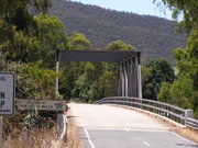
| Bringenbrong Bridge | 36°10′8"S 148°01′31"E | Bringenbrong | 1961 | 87 metres (285.4 ft) long, near Corryong Corryong, Victoria Corryong is a small town in Victoria, Australia. It is located east of Albury-Wodonga, near the upper reaches of the Murray River and thus close to the New South Wales border. At the 2006 Census in Australia, Corryong had a population of 1,228.... on the Alpine Way Alpine Way The Alpine Way is a State highway in New South Wales, Australia.The Alpine Way starts near Jindabyne on the eastern side of the Snowy Mountains. It runs south-west past Thredbo and crosses the crest of the Great Dividing Range at Dead Horse Gap... |
||
| Indi Bridge | 36°14′46"S 148°02′5"E | 1961 | Connects the Indi homestead in NSW to the Upper Murray Road. Steel girder, with concrete piles and a concrete deck. Single lane, 3.7 metres (12 ft) wide. | |||
| Biggara Bridge | 36°17′46"S 148°02′17"E | Biggara | 1951 |