
Tooleybuc, New South Wales
Encyclopedia
Tooleybuc is a town in the western Riverina
district of New South Wales
, Australia
. The town is located on the Mallee Highway
, 919 kilometres (571 mi) south west of the state capital, Sydney
and 381 kilometres (236.7 mi) north west of Melbourne
. Situated on the banks of the Murray River
across from Piangil
in the neighbouring state of Victoria
, at the 2006 census, Tooleybuc has a population of 180. The town is in the Wakool Shire
Local government area.
The Post Office opened on 1 February 1873 and closed in 1885. However, a Post Office agency has been run in the town for many years, usually in the General Store.
In 1876 the settlement at Tooleybuc was described in the following terms:
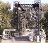
Tooleybuc is home to a historic bridge
over the Murray River. Constructed in 1907, the bridge is designed to rise to let paddle steamers
through. In 1974, the paddle steamer "Pevensey" collided with the bridge after passing through the open bridge heading upstream. The steamer attempted to move to the south bank after clearing the bridge, but was caught in the strong current and swept sideways into the east side of the bridge. The bridge sustained no noticeable damage, but the "Pevensey" suffered some damage to her upper works. After being pulled off by a team of locals who were gathered to see her come through the bridge, the "Pevensey" refueled and made minor repairs, before heading upstream to Echuca.
 The town in conjunction with nearby township Manangatang
has an Australian rules football
team competing in the Central Murray Football League
. The town first established a football team in 1903, in the Lines Football Association. This became the Nyah-Piangil Football Association soon after, and Tooleybuc won its first Premiership in 1923, defeating Woorinen
by 1 point. As a member of the Mid Valley Football Association, Tooleybuc won the Premiership in 1935. The Association became the Mid-Murray Football League, and Tooleybuc made the Grand Final on six occasions, but only managed one Premiership, when they defeated Lalbert
by 32 points in 1965. In 1997, a re-organization of football leagues in the area resulted in the creation of the Central Murray Football League. in 2004 the Tooleybuc and Manangatang football clubs merged to form the Saints. The senior team lost the Grand Final to Kerang in 2004, and won the Premiership in 2007, defeating Balranald by 45 points. In the 2011 season, the Saints won the Reserves and Under-15 Premierships.
Tooleybuc Central School is a K-12 school, opened in 1916 , and operational since that date. It has students from the NSW towns of Kyalite, Goodnight and Koraleigh, as well as farm areas within that range. It also serves students from Victoria, especially for high school, for the towns and localities of Nyah, Nyah West, Wood Wood, Piangil, Natya, Kooloonong and surrounding areas.
Riverina
The Riverina is an agricultural region of south-western New South Wales , Australia. The Riverina is distinguished from other Australian regions by the combination of flat plains, warm to hot climate and an ample supply of water for irrigation. This combination has allowed the Riverina to develop...
district of New South Wales
New South Wales
New South Wales is a state of :Australia, located in the east of the country. It is bordered by Queensland, Victoria and South Australia to the north, south and west respectively. To the east, the state is bordered by the Tasman Sea, which forms part of the Pacific Ocean. New South Wales...
, Australia
Australia
Australia , officially the Commonwealth of Australia, is a country in the Southern Hemisphere comprising the mainland of the Australian continent, the island of Tasmania, and numerous smaller islands in the Indian and Pacific Oceans. It is the world's sixth-largest country by total area...
. The town is located on the Mallee Highway
Mallee Highway
The Mallee Highway runs east from Tailem Bend in South Australia through cereal-growing farmland at the southern end of the Murray Mallee to Pinnaroo near the border with Victoria, where it crosses route...
, 919 kilometres (571 mi) south west of the state capital, Sydney
Sydney
Sydney is the most populous city in Australia and the state capital of New South Wales. Sydney is located on Australia's south-east coast of the Tasman Sea. As of June 2010, the greater metropolitan area had an approximate population of 4.6 million people...
and 381 kilometres (236.7 mi) north west of Melbourne
Melbourne
Melbourne is the capital and most populous city in the state of Victoria, and the second most populous city in Australia. The Melbourne City Centre is the hub of the greater metropolitan area and the Census statistical division—of which "Melbourne" is the common name. As of June 2009, the greater...
. Situated on the banks of the Murray River
Murray River
The Murray River is Australia's longest river. At in length, the Murray rises in the Australian Alps, draining the western side of Australia's highest mountains and, for most of its length, meanders across Australia's inland plains, forming the border between New South Wales and Victoria as it...
across from Piangil
Piangil, Victoria
Piangil is a remote town in Northern Victoria, Australia. It is approximately north west of Swan Hill. At the 2006 census, Piangil had a population of 654....
in the neighbouring state of Victoria
Victoria (Australia)
Victoria is the second most populous state in Australia. Geographically the smallest mainland state, Victoria is bordered by New South Wales, South Australia, and Tasmania on Boundary Islet to the north, west and south respectively....
, at the 2006 census, Tooleybuc has a population of 180. The town is in the Wakool Shire
Wakool Shire
Wakool Shire is a Local Government Area located between the Murray River and the Murrumbidgee River and on the Sturt Highway.Towns in the Shire are: Barham , Moulamein , Tooleybuc , Wakool and Koraleigh.- Council :...
Local government area.
The Post Office opened on 1 February 1873 and closed in 1885. However, a Post Office agency has been run in the town for many years, usually in the General Store.
In 1876 the settlement at Tooleybuc was described in the following terms:
Tooley Buc is on the New South Wales side of the river, and is on the mail road between Swan-hillSwan Hill, VictoriaSwan Hill is a city in the northwest of Victoria, Australia. It is located on the Murray Valley Highway, on the south bank of the Murray River, downstream from the junction of the Loddon River. At the 2006 census, Swan Hill had a population of 9,684.-History:...
and BalranaldBalranald, New South WalesBalranald is a town and local government area in the Riverina district of New South Wales, Australia. At the 2006 census the population was 1,216....
, being nearly equidistant between the two places. There is no township there, unless a large public-house and a small and comical-looking wooden chapel, which, by the bye, appeared to be unused, can be held to constitute one, but there is a good deal of settlement in the neighbourhood. A store and post-office are attached to the public-house. Tooley Buc is a crossing-place for sheep and cattle.
Tooleybuc is home to a historic bridge
Murray River crossings
The Murray River in south-eastern Australia has been a significant barrier to land-based travel and trade. This article lists and briefly describes all of the recognised crossing points. Many of these had also developed as river ports for transport of goods along the Murray...
over the Murray River. Constructed in 1907, the bridge is designed to rise to let paddle steamers
Steamboat
A steamboat or steamship, sometimes called a steamer, is a ship in which the primary method of propulsion is steam power, typically driving propellers or paddlewheels...
through. In 1974, the paddle steamer "Pevensey" collided with the bridge after passing through the open bridge heading upstream. The steamer attempted to move to the south bank after clearing the bridge, but was caught in the strong current and swept sideways into the east side of the bridge. The bridge sustained no noticeable damage, but the "Pevensey" suffered some damage to her upper works. After being pulled off by a team of locals who were gathered to see her come through the bridge, the "Pevensey" refueled and made minor repairs, before heading upstream to Echuca.
Manangatang, Victoria
Manangatang is a remote town in north-west Victoria, Australia. At the 2006 census, Manangatang had a population of 448. It is sometimes noted for its unusual name, from an Aboriginal term - "manang" meaning land and "kaaiti" meaning water....
has an Australian rules football
Australian rules football
Australian rules football, officially known as Australian football, also called football, Aussie rules or footy is a sport played between two teams of 22 players on either...
team competing in the Central Murray Football League
Central Murray Football League
The Central Murray Football League is a major country Australian rules football competition based in northern Victoria, Australia and southwest New South Wales, Australia.-History:...
. The town first established a football team in 1903, in the Lines Football Association. This became the Nyah-Piangil Football Association soon after, and Tooleybuc won its first Premiership in 1923, defeating Woorinen
Woorinen South, Victoria
Woorinen South is a town in Victoria, Australia. It is situated within the Rural City of Swan Hill within the Mallee region of north-west Victoria. At the 2006 census, Woorinen South had a population of 315. The town is located north-west of Melbourne and km north-west of the regional centre...
by 1 point. As a member of the Mid Valley Football Association, Tooleybuc won the Premiership in 1935. The Association became the Mid-Murray Football League, and Tooleybuc made the Grand Final on six occasions, but only managed one Premiership, when they defeated Lalbert
Lalbert, Victoria
Lalbert is a very small farming town in the north-west of Victoria, Australia within the Shire of Gannawarra. Lalbert is situated west of Kerang on the Swan Hill-Donald Road...
by 32 points in 1965. In 1997, a re-organization of football leagues in the area resulted in the creation of the Central Murray Football League. in 2004 the Tooleybuc and Manangatang football clubs merged to form the Saints. The senior team lost the Grand Final to Kerang in 2004, and won the Premiership in 2007, defeating Balranald by 45 points. In the 2011 season, the Saints won the Reserves and Under-15 Premierships.
Tooleybuc Central School is a K-12 school, opened in 1916 , and operational since that date. It has students from the NSW towns of Kyalite, Goodnight and Koraleigh, as well as farm areas within that range. It also serves students from Victoria, especially for high school, for the towns and localities of Nyah, Nyah West, Wood Wood, Piangil, Natya, Kooloonong and surrounding areas.
External links
- Wakool Shire Council - Official site