
Lake Mulwala
Encyclopedia
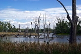
Lake Mulwala was created in 1939 by building a dam across the Murray River
between Yarrawonga
in Victoria
and Mulwala
in New South Wales
to provide irrigation water for the surrounding district. Crossing the Murray
between the two towns is possible across the weir as well as Mulwala Bridge
.
The road bridge across the lake was built before the lake was filled, commenced in 1917 and completed in 1924. It replaced an earlier wooden bridge built in 1889-1891. The bridge was started from both ends, each by the respective state government. Unfortunately, they didn't coordinate their efforts, and the bridge has a dip and a bend in the middle to make the two ends meet.
The Yarrawonga weir is the farthest downstream obstruction across the Murray that does not have a navigation lock through it. When full, the lake is 124.9 metres above sea level. The weir is 1992 kilometres upstream from the Murray Mouth
.
 Lake Mulwala is a renowned fishery for the native Murray Cod
and is one of the few places where this Australian native freshwater fish is still reasonably common.
Murray River
The Murray River is Australia's longest river. At in length, the Murray rises in the Australian Alps, draining the western side of Australia's highest mountains and, for most of its length, meanders across Australia's inland plains, forming the border between New South Wales and Victoria as it...
between Yarrawonga
Yarrawonga, Victoria
Yarrawonga is a town in the Shire of Moira Local Government Area in the Australian state of Victoria. The town is situated on the south bank of the Murray River, the border between Victoria and New South Wales and is located approximately north-east of the state capital, Melbourne. Yarrawonga's...
in Victoria
Victoria (Australia)
Victoria is the second most populous state in Australia. Geographically the smallest mainland state, Victoria is bordered by New South Wales, South Australia, and Tasmania on Boundary Islet to the north, west and south respectively....
and Mulwala
Mulwala, New South Wales
Mulwala is a town in the Corowa Shire Local Government Area in the Riverina district of New South Wales, Australia. The town is situated on Lake Mulwala, an artificial lake formed by the damming of the Murray River. At the 2006 census, Mulwala had a population of 1,986 people...
in New South Wales
New South Wales
New South Wales is a state of :Australia, located in the east of the country. It is bordered by Queensland, Victoria and South Australia to the north, south and west respectively. To the east, the state is bordered by the Tasman Sea, which forms part of the Pacific Ocean. New South Wales...
to provide irrigation water for the surrounding district. Crossing the Murray
Murray River crossings
The Murray River in south-eastern Australia has been a significant barrier to land-based travel and trade. This article lists and briefly describes all of the recognised crossing points. Many of these had also developed as river ports for transport of goods along the Murray...
between the two towns is possible across the weir as well as Mulwala Bridge
Mulwala Bridge
Mulwala Bridge is a bridge crossing Lake Mulwala, formed by a weir on the Murray River in Australia. The bridge links the border towns of Yarrawonga, Victoria and Mulwala, New South Wales. The bridge was built in 1924 and designed by Percy Allan using a Pratt truss.-References:...
.
The road bridge across the lake was built before the lake was filled, commenced in 1917 and completed in 1924. It replaced an earlier wooden bridge built in 1889-1891. The bridge was started from both ends, each by the respective state government. Unfortunately, they didn't coordinate their efforts, and the bridge has a dip and a bend in the middle to make the two ends meet.
The Yarrawonga weir is the farthest downstream obstruction across the Murray that does not have a navigation lock through it. When full, the lake is 124.9 metres above sea level. The weir is 1992 kilometres upstream from the Murray Mouth
Murray Mouth
Murray Mouth is the point at which the River Murray meets the southern Southern Ocean. The Murray Mouth's location is changeable. Historical records show that the channel out to sea moves along the sand dunes over time...
.
Murray Cod
The Murray cod is a large Australian predatory freshwater fish of the Maccullochella genus and the Percichthyidae family. Although the species is a called cod in the vernacular, it is not related to the northern hemisphere marine cod species...
and is one of the few places where this Australian native freshwater fish is still reasonably common.