
Municipal expressways in Toronto
Encyclopedia
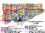
The cancelled expressways in Toronto were a planned series of expressway
s in Toronto
, Ontario
, Canada
that were only partially built or cancelled due to public opposition. The system of expressways was intended to spur or handle growth in the suburbs of Toronto, but were opposed by citizens within the City of Toronto proper, citing the demolition of homes and park lands, air pollution, noise and the high cost of construction. The Spadina Expressway
, planned since the 1940s, was cancelled in 1971 after being only partially constructed. After the Spadina cancellation, other expressway plans, intended to create a 'ring' around the central core, were abandoned.
. In 1943, the City of Toronto Planning Board developed a plan for the area within a nine-mile radius of Yonge Street and Queen Street. It included a network of superhighways:
Source: Sewell( 2009)
With the creation of Metropolitan Toronto (Metro) in 1953, a new level of government was created with the authority to build what was necessary to facilitate the growth expected within the Metro area. Metro would build the infrastructure, such as sewers, sewage treatment plants, public transit, highways and arterial roads, leaving local roads and land use planning to the individual governments. Along with the Ontario provincial government, Metro planned to build an extensive network of highways that crisscrossed the city, handling projected commuter traffic loads within the Metro area. While the provincial government would plan and build highways crossing Metro and highways to connect to municipalities outside of Metro, Metro would focus on roads serving the downtown core and connecting the downtown core to the growing suburbs.
by 1964. During construction the Lakeshore was renamed the Gardiner Expressway
, after the first chair of Metropolitan Toronto and major supporter of the expressway plans, Fred Gardiner. A second expressway, the Don Valley Parkway
, opened between Bloor Street
and Eglinton Avenue
in 1961, and continued to develop north and south until it connected to Highway 401 in the north and the Gardiner Expressway in the south.
These plans were only the beginning of an even larger network that was first proposed in 1959 and fully developed by 1966, when it became the official plan. In 1959, Metro developed the concept of 'rings' of expressways around the central core. The inner ring included the Crosstown east-west along Davenport connecting to the Don Valley in the east and the Highway 400 extension to the west, the Highway 400 extension down Christie and Grace Streets from Davenport, connecting to the Gardiner near Fort York
just west of the downtown core, and the Gardiner and Don Valley Expressways. The outer ring is composed of Highway 401 along the north, Highway 427 on the west, the Gardiner on the south and the Scarborough to the east, connecting the Gardiner Expressway in the downtown core with Highway 401 in the far eastern reaches of the city. Other links included the Richview, a shorter at-grade expressway connecting the western end of the Crosstown at the Highway 400 extension with Highway 27
further west, and eventually connecting to the proposed Highway 403 and the Spadina Expressway which ran north-south and connected the middle of 401 with the downtown core, ending on Spadina Avenue
near the University of Toronto
.
By 1962, the Spadina Expressway was approved and construction proceeded in 1963 from Wilson Avenue south to Lawrence Avenue. At first, Metro approved only the construction from Lawrence to Wilson. However, the province would not give funds for its construction unless Metro approved the whole route, which was done. During construction, priority was given to access to the new Yorkdale Shopping Centre, which opened in 1964. Drivers could drive from Lawrence Avenue north along a paved section of the expressway north to Yorkdale. The interchange to Highway 401 would be completed later. In 1961, one link in the inner ring, the Crosstown, was cancelled by Metro Council, although carried forward by Metro planning officials. Toronto and Metro proposed alternate routes for Highway 400, with Toronto favouring a route along the railway lines.
Metro developed its official transportation plan, starting in 1964 by evaluating three concepts, a road-oriented plan, a transit-oriented plan and a mixed plan, referred to as the 'balanced system'. The road-oriented system omitted the Spadina subway, and included all of the expressways. The mixed system did not omit any roads, but did omit a Queen Street subway. The transit-oriented plan included Eglinton Avenue and Queen Street subways, extending the Spadina north to Vaughan, and extending the Bloor-Danforth line east into Scarborough. It also included express bus routes along the expressways and commuter rail. The inner ring of highways was not included.
Sources:
The balanced plan, expected to be implemented by 1980, was estimated to cost $1 billion to construct. The expressway component (Crosstown, Spadina and Gardiner and Don Valley extensions) was estimated to cost $210 million.
The mixed system, although it was the most expensive, was approved by Metro Council in December 1966. The official plan now included the Crosstown again, although it was not approved for construction. Toronto still rejected the Crosstown, and the Ontario government rewrote the Toronto city official plan to accept that it might be built. Construction of the Crosstown was not expected until the 1970s. After completion of the Spadina south to Lawrence, approval was then given to proceed south to Eglinton, and start the process of expropriating homes and park lands for its construction, although without an interchange for the Crosstown.
, The Annex
, Harbord Village, Kensington Market
and Chinatown
neighbourhoods, while the Crosstown would present a below-grade barrier on The Annex's northern border. The Crosstown would run beside Rosedale
on its eastern end, displacing a forested ravine.
A new resident to The Annex, Jane Jacobs
, had been instrumental in blocking the Lower Manhattan Expressway
in New York City
before moving to Canada in 1969. According to Jacobs, it was the construction of expressways into major American cities that led to an exodus of the middle class, and the death of once-vibrant downtown cores. With David and Nadine Nowlan they formed the "Stop Spadina And Save Our City" group, which grew to become a major rallying point for anti-expressway feeling in the city. By the late 1960s the Spadina Expressway had become a "hot" topic politically.
To add to the problems, by 1969 construction of the Spadina Expressway had just reached Eglinton Avenue (although paved only to Lawrence Avenue
), less than half its planned route, but had already spent almost all of its $79 million budget. Metro Toronto had to return to the Ontario Municipal Board
for additional loans to complete the project, which were provided in a 2-to-1 decision. Stop Spadina appealed, and construction was halted pending the outcome. In 1971 Premier John Robarts
retired and handed the Premiership to William Davis
, who agreed to hear an appeal of the Municipal Board's decision.
Davis agreed to continue funding for the construction of the Toronto Transit Commission
(TTC) subway line (now part of the Yonge-University-Spadina Line) that was part of the original Expressway plans, and later, in 1972, agreed to complete the unfinished portion of the Expressway between Eglinton and Lawrence. The debate on whether or not to continue the Expressway further south from Eglinton continued throughout the 1970s. Eglinton was not designed to handle the loads imposed by the Expressway and has to be controlled by traffic lights at the intersection, causing southbound traffic to often back up to Lawrence during rush hour.
to Weston Road
. The western terminus of the Richview forms the oversized interchange between Highways 401 and 427 and Eglinton Avenue near Pearson Airport
. Highway 403 was built but connects to Highway 401, farther west. Both ends of the Scarborough Expressway were built, in the east as a large interchange that quickly turns into a much smaller exchange with Kingston Road
, and in the downtown core as a several-kilometer extension of the Gardiner past the Don Valley Parkway to Leslie Street.
Lands acquired for the proposed Scarborough and Richview Expressways remained in municipal government ownership for another twenty years after the shelving of the proposals. Much of the land remains in public ownership today, though future uses have not yet been determined. In 2001, the Gardiner extension was demolished between the Don Valley Parkway and Leslie Street, and there are plans to remove the connection to the Don Valley Parkway entirely.
 In the subsequent decades, the Peel Region and York Region suburbs of Toronto have expanded greatly in population and industrial development. The availability of land for development and pro-development municipal governments has led to extensive residential and industrial development. An extensive highway network has been developed of Highways 403, 407, 410, 427 and 404 within those suburbs. In comparison, the City has not built any new expressways since the cancellation of the Spadina.
As an alternative to road construction, the city and province have made efforts to expand the TTC services within the core and expand GO Transit
commuter train service. Although TTC ridership declined in the 1980s and 1990s, it has recently begun to reverse the trend. In 2008, a new record for ridership was set, indicating a growing demand for alternatives to private vehicles for personal transportation. Since the expressways reached capacity in the 1970s, commuting has been handled by increased transit, to the point that only 10% of commuters use the Gardiner Expressway to get downtown, according to 2006 figures.
The debate continues to this day about the merits of the canceled expressways. Highway advocates, including some industry and suburban commuters, believe in the necessity of the expressways to meet high demand from suburban growth and automobile traffic between suburbs and the downtown core. Those advocates also believe in the necessity of new expressways to reduce the traffic congestion of the existing expressways. Opposing groups, including residents of the core, are opposed to expansion because of the air pollution, noise and health effects associated with expressways. These impact the standard of living in urban areas and hinder urban growth. Transit advocates point to the higher capacity of a transit line compared to an expressway as a better use of government resources. Cycling advocates promote cycling routes as an alternative for commuting and recreation.
Special interest groups have formed to advocate for expressway construction in Toronto. A Scarborough
-based citizen group called the Citizens' Transportation Alliance of Greater Toronto advocates for a restart of expressway construction in Toronto. The group proposes the construction of one new expressway to the northwest of Toronto, most likely an expansion of Black Creek Drive, and one expressway to the east through Scarborough, along a hydro corridor or an expansion of Kingston Road. The group also supports filling in the 'missing links' of the arterial road grid. Based upon the group's proposal, a prominent association of automobile owners, the Canadian Automobile Association
, published a plan of expansion within the City borders to address the congestion. This included the building of a new Scarborough Expressway through a route over Lake Ontario
, new expressways and arterial roads and the building of the Richview Expressway.
The City of Toronto, along with the Province of Ontario, is focused instead on transit alternatives. The City aims to reduce the need for highways through improvements and additions to the current transit network, as described in the Transit City
plan. In April 2009, the province announced that several initiatives of the Transit City plan, including an east-west Eglinton Light Rail line connecting to the airport would proceed on accelerated construction schedules.
Other plans debated during municipal elections have included the development of new toll highways and/or expansion of current expressways through the conversion to tolls. However, Toll highways have been seen as political poison
, and no politician has made them a part of any election campaign.
/CP
railway corridor north of Dupont Street to Mount Pleasant Road. East of Mount Pleasant Road, the expressway would have cut through the neighbourhood of Rosedale to connect with the Don Valley Parkway. This section would have been built through ravine parklands.
In 1964, Metro Planning Commissioner Eli Comay proposed the extension of Bay Street north of Davenport, to connect with a future Crosstown. Comay publicly criticized the City of Toronto for allowing an apartment development at Davenport and Hillsboro Avenue, in the path of his proposed Bay Street extension. Toronto Controller and future Toronto mayor William Dennison accused Comay of setting Metro policy by himself, as the Crosstown had been rejected. Toronto Board of Control voted to reject Comay and allowed the development to proceed.
Metro Council instructed planners to cease working on the Crosstown proposal twice. Metro Chairman William Allen quipped: "The only way to get the Crosstown out of my mind is to leave the country." The Crosstown reappeared in the 1965 transportation plan developed by Metro's Planning and Transportation Departments and was then approved by Metro Council. The City of Toronto's official plan had no Crosstown Expressway, and the Ontario Minister of Municipal Affairs rejected and rewrote that section of the City's plan to conform with the Metro official plan. The City of Toronto remained consistently opposed to the Crosstown.
Extension and Bloor Street would have been integrated into the project. When the first section of the Don Valley was opened from Bloor Street to Eglinton Avenue, the roadway was the southern terminus, and is still used as an on/off ramp for the Parkway. Sections of the Parkway south of the road, and north of Eglinton Avenue were opened later. The unnamed roadway is a four-lane arterial road with interchanges at either end. The interchange with the Don Valley is named the 'Chester Hill' interchange.
valley to Highway 407 which itself was under planning at that time. In phase 2,beyond Highway 407, the proposed route was between the Ninth Line and the York-Durham Line in Markham
, leading to Stouffville. It was a last priority for the province and construction was not planned to have begun until the Scarborough Expressway was completed. It was not an extension of the Scarborough Expressway as the Scarborough's western terminus would have been 2 km west of East Metro's southern terminus.
After the cancellation of the Spadina Expressway, the Scarborough Expressway was put on hold and went into review. Toronto, Metro Toronto, and Ontario had 4 choices left. Choices 2,3, and 4 included the East Metro Freeway. Choice 2 was selected. This choice didn't have the Scarborough Expressway. With the Scarborough gone, the East Metro route was less necessary. It also encountered serious opposition from Rouge River naturalist groups. The proposal was officially dropped from planning documents on June 1, 1994.
Donald Cousens Parkway follows a route similar to the proposed East Metro Freeway, but lies entirely within Markham
now.
 The Richview Expressway was only partially completed due to concerns of under-utilization and opposition from local residents. Even though Richview Expressway was never built, it did result in widening of a section of Eglinton Avenue from Black Creek Drive to Highway 427.
The Richview Expressway has also been known as the Hamilton Expressway, since the original routing for Highway 403 (a main route for Torontonians to travel to Hamilton
) was planned to terminate at present site of the interchange between Highway 401 and Highway 427. If the original routing of Highway 403 had been carried out, then Metro's Richview Expressway would have been considered a municipal extension of Highway 403.
From west to east:
From a road-transportation standpoint, it remains a major "missing link" in the city's expressway system, as traffic entering Toronto from the east would have travelled directly downtown, as well as serving the south-east area of Toronto. Instead, that traffic is combined with traffic entering from the north along the Don Valley Parkway, where traffic volume significantly exceeds capacity on a daily basis. This has spurred various road advocates to propose new routes to keep the idea alive.
 This road was first conceived as part of planning studies in the 1940s, and detailed planning for the new freeway began in 1967. Construction was expected to begin after completion of the Spadina Expressway. Early plans had the road travelling beside the CN route in the southern parts of the then Borough of Scarborough, but later plans were to have the highway continue as an eastern extension of the Gardiner Expressway along the shores of Lake Ontario, connecting with Highway 401 by incorporating the existing Highway 2A
, a short stub freeway segment that was part of the original 401 alignment.
The original 1967 proposal would have seen 1,200 homes demolished for the expressway. After fierce opposition to this plan, the City redesigned the route in 1973. It was moved entirely to within the Lakeshore East CN/GO railway corridor, commencing from the Don Valley Parkway/Gardiner Expressway interchange and would be depressed in a deep ditch. The number of homes to be demolished was reduced to 706. However, this did not pacify east Toronto residents who continued to fight the plan. The City shelved the expressway in 1974.
Property along the road had been bought by Metro Toronto and some infrastructure was built. However, Metro faced opposition from the City of Toronto, which caused the road to be severed from the Gardiner Expressway. The fiercest opposition came from eastern Toronto, so this section was deleted. Only a route within Scarborough remained proposed. However, it would have come to an abrupt end at Victoria Park Avenue
at the Toronto/Scarborough boundary, potentially flooding east end neighbourhoods with traffic. Local residents continued to fight the plan and appeared before the Ontario Municipal Board to oppose Metro every time it tried to purchase more land for the route. Metro Toronto and Scarborough continued to push for the expressway, now known as the Scarborough Transportation Corridor. Along with this corridor, parts of Eglinton Avenue East were considered as a potential arterial highway to relieve Highway 401.
Much of the land acquired for the expressway route across Scarborough remains vacant, however the City of Toronto is carrying out studies on what to do with the lands. Ideas include local streets, housing projects and public parkland. Bridges along the CN/GO corridor were generally built with room to place two-lanes of road on either side of the railway, these are empty today and allow for future rail upgrades.
In the early 2000s, much of the land east of Manse Road in Scarborough was sold by the City of Toronto for other purposes. The parcel between Kingston Road and Lawrence Avenue was developed into homes, and a police station was constructed on a parcel on the south side of Lawrence Avenue.
and Nordheimer Ravines
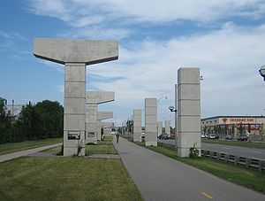
and Spadina Road, it was only partially built before being cancelled in 1971 by the Ontario government due to public opposition. It was proposed in the mid-1960s as part of a network of freeways for Metropolitan Toronto. The completed section is known today as Allen Road
.
Limited-access road
A limited-access road known by various terms worldwide, including limited-access highway, dual-carriageway and expressway, is a highway or arterial road for high-speed traffic which has many or most characteristics of a controlled-access highway , including limited or no access to adjacent...
s in Toronto
Toronto
Toronto is the provincial capital of Ontario and the largest city in Canada. It is located in Southern Ontario on the northwestern shore of Lake Ontario. A relatively modern city, Toronto's history dates back to the late-18th century, when its land was first purchased by the British monarchy from...
, Ontario
Ontario
Ontario is a province of Canada, located in east-central Canada. It is Canada's most populous province and second largest in total area. It is home to the nation's most populous city, Toronto, and the nation's capital, Ottawa....
, Canada
Canada
Canada is a North American country consisting of ten provinces and three territories. Located in the northern part of the continent, it extends from the Atlantic Ocean in the east to the Pacific Ocean in the west, and northward into the Arctic Ocean...
that were only partially built or cancelled due to public opposition. The system of expressways was intended to spur or handle growth in the suburbs of Toronto, but were opposed by citizens within the City of Toronto proper, citing the demolition of homes and park lands, air pollution, noise and the high cost of construction. The Spadina Expressway
Spadina Expressway
The Spadina Expressway was a proposed north-south freeway in Toronto, Ontario, Canada. It was only partially built before being cancelled in 1971 due to public opposition. It was proposed in the mid-1960s as part of a network of freeways for Metropolitan Toronto. Its cancellation prompted the...
, planned since the 1940s, was cancelled in 1971 after being only partially constructed. After the Spadina cancellation, other expressway plans, intended to create a 'ring' around the central core, were abandoned.
History
By the 1940s, urban development extended past the City of Toronto's borders. It was recognized within the planning department of the city that population growth would take place and that the farmlands outside of the City's border would be developedUrban sprawl
Urban sprawl, also known as suburban sprawl, is a multifaceted concept, which includes the spreading outwards of a city and its suburbs to its outskirts to low-density and auto-dependent development on rural land, high segregation of uses Urban sprawl, also known as suburban sprawl, is a...
. In 1943, the City of Toronto Planning Board developed a plan for the area within a nine-mile radius of Yonge Street and Queen Street. It included a network of superhighways:
- A. Lakeshore Expressway (which was implemented as the Gardiner Expressway), from QEW-427 interchange along the waterfront east to Scarborough eastern border,
- B. Spadina Expressway
- C. North along Coxwell north to today's Don Valley and 401 interchange,
- D. Toronto By-Pass (this comprised the highway stretches of today's Highway 427 from the QEW to 401 and Highway 401 from Highway 427 to Pickering)
- E. From 427-QEW interchange, along Bloor Street east to meet Don Valley, then east along Gerrard to meet Lakeshore at Victoria Park
- An unnamed highway which started at the foot of today's Don Valley, then north-west to Eglinton, then west along Eglinton to the vicinity of Pearson airport.
Source: Sewell( 2009)
With the creation of Metropolitan Toronto (Metro) in 1953, a new level of government was created with the authority to build what was necessary to facilitate the growth expected within the Metro area. Metro would build the infrastructure, such as sewers, sewage treatment plants, public transit, highways and arterial roads, leaving local roads and land use planning to the individual governments. Along with the Ontario provincial government, Metro planned to build an extensive network of highways that crisscrossed the city, handling projected commuter traffic loads within the Metro area. While the provincial government would plan and build highways crossing Metro and highways to connect to municipalities outside of Metro, Metro would focus on roads serving the downtown core and connecting the downtown core to the growing suburbs.
Beginning of construction
Construction of the network started with what was then known as the Lakeshore Expressway, which would connect the QEW from its terminus at the Humber River with the downtown core. The initial western section opened in 1958, continuing eastward as an elevated highway to York Street in the city core in 1962, and further to the Don RiverDon River (Toronto)
The Don River is one of two rivers bounding the original settled area of Toronto, Ontario along the shore of Lake Ontario, the other being the Humber River to the west. The Don is formed from two rivers, the East and West Branches, that meet about north of Lake Ontario while flowing southward into...
by 1964. During construction the Lakeshore was renamed the Gardiner Expressway
Gardiner Expressway
The Frederick G. Gardiner Expressway, colloquially referred to as "the Gardiner", is a municipal expressway in the Canadian province of Ontario, connecting downtown Toronto with its western suburbs...
, after the first chair of Metropolitan Toronto and major supporter of the expressway plans, Fred Gardiner. A second expressway, the Don Valley Parkway
Don Valley Parkway
The Don Valley Parkway is a controlled-access six-lane municipal expressway in Toronto connecting the Gardiner Expressway in downtown Toronto with Ontario Highway 401, the Macdonald–Cartier Freeway. North of Highway 401, it continues as Ontario Highway 404. The parkway runs through...
, opened between Bloor Street
Bloor Street
Bloor Street is a major east–west residential and commercial thoroughfare in Toronto, in the Canadian province of Ontario. Bloor Street runs from the Prince Edward Viaduct westward into Mississauga, where it ends at Central Parkway. East of the viaduct, Danforth Avenue continues along the same...
and Eglinton Avenue
Eglinton Avenue
Eglinton Avenue, originally known as the Richview Sideroad within Etobicoke, is an east-west arterial thoroughfare in Toronto and Mississauga, in the Canadian province of Ontario. Within Toronto, Eglinton Avenue is the only road which crosses through all six former boroughs...
in 1961, and continued to develop north and south until it connected to Highway 401 in the north and the Gardiner Expressway in the south.
These plans were only the beginning of an even larger network that was first proposed in 1959 and fully developed by 1966, when it became the official plan. In 1959, Metro developed the concept of 'rings' of expressways around the central core. The inner ring included the Crosstown east-west along Davenport connecting to the Don Valley in the east and the Highway 400 extension to the west, the Highway 400 extension down Christie and Grace Streets from Davenport, connecting to the Gardiner near Fort York
Fort York
Fort York is a historic site of military fortifications and related buildings on the west side of downtown Toronto, Ontario, Canada. The fort was built by the British Army and Canadian militia troops in the late 18th and early 19th centuries, to defend the settlement and the new capital of the...
just west of the downtown core, and the Gardiner and Don Valley Expressways. The outer ring is composed of Highway 401 along the north, Highway 427 on the west, the Gardiner on the south and the Scarborough to the east, connecting the Gardiner Expressway in the downtown core with Highway 401 in the far eastern reaches of the city. Other links included the Richview, a shorter at-grade expressway connecting the western end of the Crosstown at the Highway 400 extension with Highway 27
Highway 27 (Ontario)
Highway 27, formerly known as King's Highway 27, was a provincially maintained highway in southern Ontario that is now cared for by the city of Toronto, York Region and Simcoe County. It is considered an undivided expressway in Toronto's municipal expressway network...
further west, and eventually connecting to the proposed Highway 403 and the Spadina Expressway which ran north-south and connected the middle of 401 with the downtown core, ending on Spadina Avenue
Spadina Avenue
Spadina Avenue is one of the most prominent streets in Toronto, Ontario, Canada. Running through the western section of downtown, the road has a very different character in different neighbourhoods....
near the University of Toronto
University of Toronto
The University of Toronto is a public research university in Toronto, Ontario, Canada, situated on the grounds that surround Queen's Park. It was founded by royal charter in 1827 as King's College, the first institution of higher learning in Upper Canada...
.
By 1962, the Spadina Expressway was approved and construction proceeded in 1963 from Wilson Avenue south to Lawrence Avenue. At first, Metro approved only the construction from Lawrence to Wilson. However, the province would not give funds for its construction unless Metro approved the whole route, which was done. During construction, priority was given to access to the new Yorkdale Shopping Centre, which opened in 1964. Drivers could drive from Lawrence Avenue north along a paved section of the expressway north to Yorkdale. The interchange to Highway 401 would be completed later. In 1961, one link in the inner ring, the Crosstown, was cancelled by Metro Council, although carried forward by Metro planning officials. Toronto and Metro proposed alternate routes for Highway 400, with Toronto favouring a route along the railway lines.
Metro developed its official transportation plan, starting in 1964 by evaluating three concepts, a road-oriented plan, a transit-oriented plan and a mixed plan, referred to as the 'balanced system'. The road-oriented system omitted the Spadina subway, and included all of the expressways. The mixed system did not omit any roads, but did omit a Queen Street subway. The transit-oriented plan included Eglinton Avenue and Queen Street subways, extending the Spadina north to Vaughan, and extending the Bloor-Danforth line east into Scarborough. It also included express bus routes along the expressways and commuter rail. The inner ring of highways was not included.
| 'Balanced' plan | Road-oriented | Transit-oriented | |
|---|---|---|---|
| Facilities | |||
| Distance of expresswaysA | 175 mi (281.6 km) | 177 mi (284.9 km) | 81 mi (130.4 km) |
| Distance of rapid transit lines | 29 mi (46.7 km) | 14 mi (22.5 km) | 88 mi (141.6 km) |
| System performance | |||
| Average trip speed | 20.6 mph (33.2 km/h) | 16.8 mph (27 km/h) | 19.7 mph (31.7 km/h) |
| Average trip time | 28.9 min | 31.9 min | 28.3 min |
| Vehicle performance | |||
| Average vehicle speed | 26.5 mph (42.6 km/h) | 22.7 mph (36.5 km/h) | 20.6 mph (33.2 km/h) |
| Average speed on expressways | 38.9 mph (62.6 km/h) | 30.9 mph (49.7 km/h) | 23 mph (37 km/h) |
| Average speed on arterial roads | 21.9 mph (35.2 km/h) | 18.1 mph (29.1 km/h) | 19.6 mph (31.5 km/h) |
| Average trip length | 11.3 mi (18.2 km) | 10.8 mi (17.4 km) | 8.7 mi (14 km) |
| Average trip time | 25.6 min | 28.5 min | 25.5 min |
| CostsB | |||
| Costs below the balanced system | base cost | $240 million below | $912 million below |
| Congestion | |||
| Distance of heavily congested roads | 32 mi (51.5 km) | 28 mi (45.1 km) | 32 mi (51.5 km) |
| Location of heavy congestion | mainly downtown | scattered, some downtown | scattered, none downtown, none on Bathurst |
- A - Distances were direct routes between points, not distances along road alignments
- B - costs were estimated by Nowlan at $16 million per actual mile ($26 million per km) (the base routes were 197 mi (317 km) of expressway)
Sources:
- Metro Toronto Planning Board, The Metropolitan Transportation Plan, 1964.
- Nowlan and Nowlan (1970), pg. 42
The balanced plan, expected to be implemented by 1980, was estimated to cost $1 billion to construct. The expressway component (Crosstown, Spadina and Gardiner and Don Valley extensions) was estimated to cost $210 million.
The mixed system, although it was the most expensive, was approved by Metro Council in December 1966. The official plan now included the Crosstown again, although it was not approved for construction. Toronto still rejected the Crosstown, and the Ontario government rewrote the Toronto city official plan to accept that it might be built. Construction of the Crosstown was not expected until the 1970s. After completion of the Spadina south to Lawrence, approval was then given to proceed south to Eglinton, and start the process of expropriating homes and park lands for its construction, although without an interchange for the Crosstown.
Problems and protests
The construction plans became a point of growing protests in the late 1960s and early 1970s. The route of the Gardiner Expressway and the Don Valley Parkway had run mostly through industrial areas, parkland, or generally unused areas and had not generated much public concern during early construction. This changed as the Gardiner Expressway approached the downtown area, which resulted in the demolishing of long-established neighbourhoods. The planned expressways would require the same throughout the city and, with the exception of the northern ends of the roads, generally ran though well-settled areas. In particular, the Spadina Expressway ran through the Forest HillForest Hill, Toronto
Forest Hill is an affluent neighbourhood in central Toronto, Ontario, Canada. Along with Lawrence Park, Rosedale, and The Bridle Path, it is one of Toronto’s wealthiest neighbourhoods.-History:...
, The Annex
The Annex
The Annex is a neighbourhood in downtown Toronto, Ontario, Canada. The traditional boundaries of the neighbourhood are north to Dupont Street, south to Bloor Street, west to Bathurst Street and east to Avenue Road...
, Harbord Village, Kensington Market
Kensington Market
Kensington Market is a distinctive multicultural neighbourhood in Downtown Toronto, Ontario, Canada. The Market is an older neighbourhood and one of the city's most well-known. In November 2006, it was designated a National Historic Site of Canada. Robert Fulford wrote in 1999 that "Kensington...
and Chinatown
Chinatown, Toronto
Chinatown is an ethnic enclave in Downtown Toronto, Ontario, Canada, with a high concentration of ethnic Chinese residents and businesses extending along Dundas Street West and Spadina Avenue. First developed in the late 19th century, it is now one of the largest Chinatowns in North America and...
neighbourhoods, while the Crosstown would present a below-grade barrier on The Annex's northern border. The Crosstown would run beside Rosedale
Rosedale, Toronto
Rosedale is an affluent neighbourhood in Toronto, Ontario, Canada, which was formerly the estate of William Botsford Jarvis, and so named by his wife, granddaughter of William Dummer Powell, for the wild roses that grew there in abundance....
on its eastern end, displacing a forested ravine.
A new resident to The Annex, Jane Jacobs
Jane Jacobs
Jane Jacobs, was an American-Canadian writer and activist with primary interest in communities and urban planning and decay. She is best known for The Death and Life of Great American Cities , a powerful critique of the urban renewal policies of the 1950s in the United States...
, had been instrumental in blocking the Lower Manhattan Expressway
Lower Manhattan Expressway
The Lower Manhattan Expressway was a controversial plan for an expressway through lower Manhattan originally conceived by Robert Moses in 1941, but delayed until the early 1960s...
in New York City
New York City
New York is the most populous city in the United States and the center of the New York Metropolitan Area, one of the most populous metropolitan areas in the world. New York exerts a significant impact upon global commerce, finance, media, art, fashion, research, technology, education, and...
before moving to Canada in 1969. According to Jacobs, it was the construction of expressways into major American cities that led to an exodus of the middle class, and the death of once-vibrant downtown cores. With David and Nadine Nowlan they formed the "Stop Spadina And Save Our City" group, which grew to become a major rallying point for anti-expressway feeling in the city. By the late 1960s the Spadina Expressway had become a "hot" topic politically.
To add to the problems, by 1969 construction of the Spadina Expressway had just reached Eglinton Avenue (although paved only to Lawrence Avenue
Lawrence Avenue
Lawrence Avenue is a major east-west thoroughfare in Toronto, Ontario, Canada. It is divided into east and west portions by Yonge Street, the dividing line of east-west streets in Toronto....
), less than half its planned route, but had already spent almost all of its $79 million budget. Metro Toronto had to return to the Ontario Municipal Board
Ontario Municipal Board
The Ontario Municipal Board is an independent administrative board, operated as an adjudicative tribunal, in the province of Ontario, Canada...
for additional loans to complete the project, which were provided in a 2-to-1 decision. Stop Spadina appealed, and construction was halted pending the outcome. In 1971 Premier John Robarts
John Robarts
John Parmenter Robarts, PC, CC, QC was a Canadian lawyer and statesman, and the 17th Premier of Ontario.-Early life:...
retired and handed the Premiership to William Davis
Bill Davis
William Grenville "Bill" Davis, was the 18th Premier of Ontario, Canada, from 1971 to 1985. Davis was first elected as the MPP for Peel in the 1959 provincial election where he was a backbencher in Leslie Frost's government. Under John Robarts, he was a cabinet minister overseeing the education...
, who agreed to hear an appeal of the Municipal Board's decision.
Cancellation
On June 3, 1971 Davis rose in the Provincial Legislature and stated:Davis agreed to continue funding for the construction of the Toronto Transit Commission
Toronto Transit Commission
-Island Ferry:The ferry service to the Toronto Islands was operated by the TTC from 1927 until 1962, when it was transferred to the Metro Parks and Culture department. Since 1998, the ferry service is run by Toronto Parks and Recreation.-Gray Coach:...
(TTC) subway line (now part of the Yonge-University-Spadina Line) that was part of the original Expressway plans, and later, in 1972, agreed to complete the unfinished portion of the Expressway between Eglinton and Lawrence. The debate on whether or not to continue the Expressway further south from Eglinton continued throughout the 1970s. Eglinton was not designed to handle the loads imposed by the Expressway and has to be controlled by traffic lights at the intersection, causing southbound traffic to often back up to Lawrence during rush hour.
Aftermath
The cancellation of the Spadina Expressway heralded the end of the expressway plans in Toronto. Work on the other expressways in the system was simply abandoned. The Highway 400 extension stopped at Eglinton, where the province left it, although it was later extended with the at-grade Black Creek DriveBlack Creek Drive
Black Creek Drive is a north-south arterial road in Toronto, Ontario that extends from Highway 400 at Jane Street, near Ontario Highway 401 to Weston Road in the south. Originally intended to be a freeway extension of Ontario Highway 400, it was built instead as an arterial road after public...
to Weston Road
Weston Road
Weston Road is a north-south street in west end Toronto, Ontario, Canada. The route is named for the former Village of Weston, which was located near Weston Road and Lawrence Avenue West....
. The western terminus of the Richview forms the oversized interchange between Highways 401 and 427 and Eglinton Avenue near Pearson Airport
Toronto Pearson International Airport
Toronto Pearson International Airport is an international airport serving Toronto, Ontario, Canada; its metropolitan area; and the Golden Horseshoe, an urban agglomeration that is home to 8.1 million people – approximately 25% of Canada's population...
. Highway 403 was built but connects to Highway 401, farther west. Both ends of the Scarborough Expressway were built, in the east as a large interchange that quickly turns into a much smaller exchange with Kingston Road
Kingston Road (Toronto)
Kingston Road is the southernmost major road along the eastern portion of Toronto, specifically in the districts of East York and Scarborough. Until 1998, it formed a significant portion of Highway 2...
, and in the downtown core as a several-kilometer extension of the Gardiner past the Don Valley Parkway to Leslie Street.
Lands acquired for the proposed Scarborough and Richview Expressways remained in municipal government ownership for another twenty years after the shelving of the proposals. Much of the land remains in public ownership today, though future uses have not yet been determined. In 2001, the Gardiner extension was demolished between the Don Valley Parkway and Leslie Street, and there are plans to remove the connection to the Don Valley Parkway entirely.
Ongoing political debate
As an alternative to road construction, the city and province have made efforts to expand the TTC services within the core and expand GO Transit
GO Transit
GO Transit is an inter-regional public transit system in Southern Ontario, Canada. It primarily serves the Greater Toronto and Hamilton Area conurbation, with operations extending to several communities beyond the GTHA proper in the Greater Golden Horseshoe...
commuter train service. Although TTC ridership declined in the 1980s and 1990s, it has recently begun to reverse the trend. In 2008, a new record for ridership was set, indicating a growing demand for alternatives to private vehicles for personal transportation. Since the expressways reached capacity in the 1970s, commuting has been handled by increased transit, to the point that only 10% of commuters use the Gardiner Expressway to get downtown, according to 2006 figures.
The debate continues to this day about the merits of the canceled expressways. Highway advocates, including some industry and suburban commuters, believe in the necessity of the expressways to meet high demand from suburban growth and automobile traffic between suburbs and the downtown core. Those advocates also believe in the necessity of new expressways to reduce the traffic congestion of the existing expressways. Opposing groups, including residents of the core, are opposed to expansion because of the air pollution, noise and health effects associated with expressways. These impact the standard of living in urban areas and hinder urban growth. Transit advocates point to the higher capacity of a transit line compared to an expressway as a better use of government resources. Cycling advocates promote cycling routes as an alternative for commuting and recreation.
Special interest groups have formed to advocate for expressway construction in Toronto. A Scarborough
Scarborough, Ontario
Scarborough is a dissolved municipality within the city of Toronto, Ontario, Canada. Geographically, it comprises the eastern part of Toronto. It is bordered on the south by Lake Ontario, on the west by Victoria Park Avenue, on the north by Steeles Avenue East, and on the east by the Rouge River...
-based citizen group called the Citizens' Transportation Alliance of Greater Toronto advocates for a restart of expressway construction in Toronto. The group proposes the construction of one new expressway to the northwest of Toronto, most likely an expansion of Black Creek Drive, and one expressway to the east through Scarborough, along a hydro corridor or an expansion of Kingston Road. The group also supports filling in the 'missing links' of the arterial road grid. Based upon the group's proposal, a prominent association of automobile owners, the Canadian Automobile Association
Canadian Automobile Association
The Canadian Automobile Association , commonly known as CAA, is a non-profit federation, founded in 1913, of nine clubs across Canada, providing roadside assistance service, a complete range of auto touring and leisure travel services, insurance services, and member discounts with preferred...
, published a plan of expansion within the City borders to address the congestion. This included the building of a new Scarborough Expressway through a route over Lake Ontario
Lake Ontario
Lake Ontario is one of the five Great Lakes of North America. It is bounded on the north and southwest by the Canadian province of Ontario, and on the south by the American state of New York. Ontario, Canada's most populous province, was named for the lake. In the Wyandot language, ontarío means...
, new expressways and arterial roads and the building of the Richview Expressway.
The City of Toronto, along with the Province of Ontario, is focused instead on transit alternatives. The City aims to reduce the need for highways through improvements and additions to the current transit network, as described in the Transit City
Transit City
Transit City was a plan for developing public transport in Toronto, Ontario, Canada. It was first proposed and announced by then-Toronto Mayor David Miller and Chair of the Toronto Transit Commission Adam Giambrone on March 16, 2007...
plan. In April 2009, the province announced that several initiatives of the Transit City plan, including an east-west Eglinton Light Rail line connecting to the airport would proceed on accelerated construction schedules.
Other plans debated during municipal elections have included the development of new toll highways and/or expansion of current expressways through the conversion to tolls. However, Toll highways have been seen as political poison
Political suicide
Political suicide is the concept that a politician or political party would lose widespread support and confidence from the voting public by proposing actions that are seen as unfavourable or that might threaten the status quo. A politician who committed political suicide might be forced to resign...
, and no politician has made them a part of any election campaign.
Crosstown Expressway
The Crosstown Expressway was a planned east-west expressway through central Toronto. Although it was consistently opposed by the City of Toronto Council, it remained in the Metro Toronto plan until it was cancelled in the aftermath of the Spadina Expressway cancellation. In 1964, it was estimated to cost $80 million to build.Route
As part of the 1959 plan of Metropolitan Toronto, the Expressway would have connected Highway 400 extension, along an east-west route in the vicinity of Christie Street and Dupont Street, east to the Don Valley Parkway. Highway 400 would have continued south to the Gardiner Expressway. North of Spadina Road, the Spadina Expressway would have connected via an interchange. The expressway would continue east along a CNCanadian National Railway
The Canadian National Railway Company is a Canadian Class I railway headquartered in Montreal, Quebec. CN's slogan is "North America's Railroad"....
/CP
Canadian Pacific Railway
The Canadian Pacific Railway , formerly also known as CP Rail between 1968 and 1996, is a historic Canadian Class I railway founded in 1881 and now operated by Canadian Pacific Railway Limited, which began operations as legal owner in a corporate restructuring in 2001...
railway corridor north of Dupont Street to Mount Pleasant Road. East of Mount Pleasant Road, the expressway would have cut through the neighbourhood of Rosedale to connect with the Don Valley Parkway. This section would have been built through ravine parklands.
Life of the proposal
The Crosstown expressway was rejected by Metro Council in December 1961. Almost immediately afterwards transportation officials lobbied Toronto and Metro Toronto to resurrect the project. In May 1962, Toronto Public Works Commissioner Douglas Ford proposed the construction of the Crosstown, along with an extensive one-way street plan for downtown Toronto. Ford proposed this on the basis that it would be needed to absorb the traffic of the Spadina Expressway and eliminate the need for extensive road widening. He also suggested that the one-way system would preserve residential amenities and encourage development. Ford further stated that it would be folly to terminate the Spadina at other than a controlled-access expressway. Metro Planning Commissioner Murray Jones estimated that 40,000 vehicles would move daily between the Highway 400 extension and the Don Valley Parkway. Metro Traffic Director Samuel Cass suggested that the Crosstown plan would make it unnecessary for heavy traffic to use residential streets in the Rosedale and Moore Park neighbourhoods.In 1964, Metro Planning Commissioner Eli Comay proposed the extension of Bay Street north of Davenport, to connect with a future Crosstown. Comay publicly criticized the City of Toronto for allowing an apartment development at Davenport and Hillsboro Avenue, in the path of his proposed Bay Street extension. Toronto Controller and future Toronto mayor William Dennison accused Comay of setting Metro policy by himself, as the Crosstown had been rejected. Toronto Board of Control voted to reject Comay and allowed the development to proceed.
Metro Council instructed planners to cease working on the Crosstown proposal twice. Metro Chairman William Allen quipped: "The only way to get the Crosstown out of my mind is to leave the country." The Crosstown reappeared in the 1965 transportation plan developed by Metro's Planning and Transportation Departments and was then approved by Metro Council. The City of Toronto's official plan had no Crosstown Expressway, and the Ontario Minister of Municipal Affairs rejected and rewrote that section of the City's plan to conform with the Metro official plan. The City of Toronto remained consistently opposed to the Crosstown.
Interchange with Don Valley Parkway
While land was obtained, the expressway was not built, although a short connecting road built to connect the Don Valley Parkway to the Bayview AvenueBayview Avenue
Bayview Avenue is a major north-south route in the Greater Toronto Area of Ontario. North of Toronto, in York Region, Bayview is also designated as York Regional Road 34.-History:...
Extension and Bloor Street would have been integrated into the project. When the first section of the Don Valley was opened from Bloor Street to Eglinton Avenue, the roadway was the southern terminus, and is still used as an on/off ramp for the Parkway. Sections of the Parkway south of the road, and north of Eglinton Avenue were opened later. The unnamed roadway is a four-lane arterial road with interchanges at either end. The interchange with the Don Valley is named the 'Chester Hill' interchange.
East Metro Freeway
The East Metro Freeway was a proposed north-south expressway to begin at Highway 401 and Morningside Avenue and roughly follow the edge of the Rouge RiverRouge River (Ontario)
The Rouge River is a two river system. Little Rouge and Rouge River are in the east and the northeast parts of Toronto and begin in the Oak Ridges Moraine in Richmond Hill and Whitchurch-Stouffville...
valley to Highway 407 which itself was under planning at that time. In phase 2,beyond Highway 407, the proposed route was between the Ninth Line and the York-Durham Line in Markham
Markham, Ontario
Markham is a town in the Regional Municipality of York, located within the Greater Toronto Area of Southern Ontario, Canada. The population was 261,573 at the 2006 Canadian census...
, leading to Stouffville. It was a last priority for the province and construction was not planned to have begun until the Scarborough Expressway was completed. It was not an extension of the Scarborough Expressway as the Scarborough's western terminus would have been 2 km west of East Metro's southern terminus.
After the cancellation of the Spadina Expressway, the Scarborough Expressway was put on hold and went into review. Toronto, Metro Toronto, and Ontario had 4 choices left. Choices 2,3, and 4 included the East Metro Freeway. Choice 2 was selected. This choice didn't have the Scarborough Expressway. With the Scarborough gone, the East Metro route was less necessary. It also encountered serious opposition from Rouge River naturalist groups. The proposal was officially dropped from planning documents on June 1, 1994.
Donald Cousens Parkway follows a route similar to the proposed East Metro Freeway, but lies entirely within Markham
Markham, Ontario
Markham is a town in the Regional Municipality of York, located within the Greater Toronto Area of Southern Ontario, Canada. The population was 261,573 at the 2006 Canadian census...
now.
Richview Expressway
The Richview Expressway has also been known as the Hamilton Expressway, since the original routing for Highway 403 (a main route for Torontonians to travel to Hamilton
Hamilton, Ontario
Hamilton is a port city in the Canadian province of Ontario. Conceived by George Hamilton when he purchased the Durand farm shortly after the War of 1812, Hamilton has become the centre of a densely populated and industrialized region at the west end of Lake Ontario known as the Golden Horseshoe...
) was planned to terminate at present site of the interchange between Highway 401 and Highway 427. If the original routing of Highway 403 had been carried out, then Metro's Richview Expressway would have been considered a municipal extension of Highway 403.
Exit list
Although the expressway was never completed, the plans had on/off ramps for:From west to east:
| Location | Destination | Notes |
|---|---|---|
| Etobicoke | Highway 427 | |
| Eglinton Avenue West | Partial ramps | |
| Kipling Avenue Kipling Avenue Kipling Avenue, originally named Mimico Avenue, is a street in the Etobicoke district of Toronto, Ontario, Canada. It is a concession road, 6 concessions from Yonge Street, and is a major north–south arterial road that also extends beyond Toronto, into the Regional Municipality of York.The... | Full cloverleaf planned in 1960s cancelled in 1970s plan | |
| Islington Avenue | Full cloverleaf planned in 1960s cancelled in 1970s plan | |
| Royal York Road Royal York Road Royal York Road, historically known as Church Street or New Church Street, is a north-south arterial road in Toronto, Ontario, Canada. It is a concession road, 5 concessions west of Yonge Street, and runs through many residential neighbourhoods, most notably Mimico and the Kingsway... | Full cloverleaf planned in 1960s cancelled in 1970s plan | |
| York York, Ontario York is a dissolved municipality in Toronto, Ontario, Canada. Geographically, it is located northwest of Old Toronto, southwest of North York and east of Etobicoke, where it is bounded by the Humber River. Formerly a separate city, it was one of six municipalities that amalgamated in 1998 to form... | Scarlett Road | Partial cloverleaf planned in 1960s cancelled in 1970s plan |
| Jane Street | Ramps planned in 1960s cancelled in 1970s plan | |
| Mount Dennis Mount Dennis Mount Dennis is a neighbourhood in Toronto, Ontario, Canada, bordered by the intersection of Jane Street and Weston Road to the north, and Black Creek to the east and south, as the creek curves parallel to Alliance Avenue before crossing under Jane Street on its way to drain into the Humber River,... | Full cloverleafs in 1960s and 1970s plans | |
| Highway 400 southern extension | Full cloverleafs in 1960s and 1970s plans |
Scarborough Expressway
The Scarborough Expressway (Gardiner Expressway Eastern Extension) was intended to connect the Gardiner Expressway to Highway 401 at the eastern boundary of Toronto, and one segment was built before public opposition stopped the project.From a road-transportation standpoint, it remains a major "missing link" in the city's expressway system, as traffic entering Toronto from the east would have travelled directly downtown, as well as serving the south-east area of Toronto. Instead, that traffic is combined with traffic entering from the north along the Don Valley Parkway, where traffic volume significantly exceeds capacity on a daily basis. This has spurred various road advocates to propose new routes to keep the idea alive.
History
Highway 2A (Ontario)
King's Highway 2A, commonly referred to as Highway 2A, was the designation of five separate provincially maintained highways in the Canadian province of Ontario. Highway 2A was an alternate route to Highway 2 in London, Chatham and Cornwall; these routes were all eventually redesignated...
, a short stub freeway segment that was part of the original 401 alignment.
The original 1967 proposal would have seen 1,200 homes demolished for the expressway. After fierce opposition to this plan, the City redesigned the route in 1973. It was moved entirely to within the Lakeshore East CN/GO railway corridor, commencing from the Don Valley Parkway/Gardiner Expressway interchange and would be depressed in a deep ditch. The number of homes to be demolished was reduced to 706. However, this did not pacify east Toronto residents who continued to fight the plan. The City shelved the expressway in 1974.
Property along the road had been bought by Metro Toronto and some infrastructure was built. However, Metro faced opposition from the City of Toronto, which caused the road to be severed from the Gardiner Expressway. The fiercest opposition came from eastern Toronto, so this section was deleted. Only a route within Scarborough remained proposed. However, it would have come to an abrupt end at Victoria Park Avenue
Victoria Park Avenue
Victoria Park Avenue is a major north-south route in eastern Toronto, Ontario, Canada. It marks the border between the Old City of Toronto and Scarborough.-History:Victoria Park Avenue was originally a pioneer road for settlement of Scarborough...
at the Toronto/Scarborough boundary, potentially flooding east end neighbourhoods with traffic. Local residents continued to fight the plan and appeared before the Ontario Municipal Board to oppose Metro every time it tried to purchase more land for the route. Metro Toronto and Scarborough continued to push for the expressway, now known as the Scarborough Transportation Corridor. Along with this corridor, parts of Eglinton Avenue East were considered as a potential arterial highway to relieve Highway 401.
Demise
Until the early 1990s, Metro and Scarborough both continued to keep the Scarborough Expressway plan alive, but by 1994 the focus on expressways was no longer a planning priority. By 1996, Metro began to plan for the demolition the eastern end of the Gardiner Expressway, thus effectively ending the Scarborough Expressway/Scarborough Transportation Corridor. The intended connection to the Gardiner Expressway, between the Don River and Leslie St., was demolished in 2001.Much of the land acquired for the expressway route across Scarborough remains vacant, however the City of Toronto is carrying out studies on what to do with the lands. Ideas include local streets, housing projects and public parkland. Bridges along the CN/GO corridor were generally built with room to place two-lanes of road on either side of the railway, these are empty today and allow for future rail upgrades.
In the early 2000s, much of the land east of Manse Road in Scarborough was sold by the City of Toronto for other purposes. The parcel between Kingston Road and Lawrence Avenue was developed into homes, and a police station was constructed on a parcel on the south side of Lawrence Avenue.
Spadina Expressway
The Spadina Expressway was a proposed freeway to run from north of Highway 401 into the downtown of Toronto via the CedarvaleCedarvale Park (Toronto)
Cedarvale Park is a park located in Toronto, Ontario, Canada. It is bordered by very steep hills, and is located in the Cedarvale neighbourhood of Toronto. The Spadina subway line tunnels underneath it, between St. Clair West and Eglinton West stations...
and Nordheimer Ravines
Castle Frank Brook
Castle Frank Brook is a buried creek and south-west flowing tributary of the Don River in central and north-western Toronto, Ontario, originating near the intersection of Lawrence Avenue and Dufferin Street....
and Spadina Road, it was only partially built before being cancelled in 1971 by the Ontario government due to public opposition. It was proposed in the mid-1960s as part of a network of freeways for Metropolitan Toronto. The completed section is known today as Allen Road
Allen Road
William R. Allen Road, known more commonly as Allen Road, The Allen Expressway or simply The Allen and formerly as the Spadina Expressway, is a short expressway/freeway in Toronto, Ontario, which runs from Kennard Avenue in the north, to Eglinton Avenue West in the south...
.