

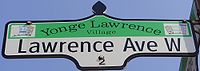
Lawrence Avenue
Encyclopedia
Toronto
Toronto is the provincial capital of Ontario and the largest city in Canada. It is located in Southern Ontario on the northwestern shore of Lake Ontario. A relatively modern city, Toronto's history dates back to the late-18th century, when its land was first purchased by the British monarchy from...
, Ontario
Ontario
Ontario is a province of Canada, located in east-central Canada. It is Canada's most populous province and second largest in total area. It is home to the nation's most populous city, Toronto, and the nation's capital, Ottawa....
, Canada
Canada
Canada is a North American country consisting of ten provinces and three territories. Located in the northern part of the continent, it extends from the Atlantic Ocean in the east to the Pacific Ocean in the west, and northward into the Arctic Ocean...
. It is divided into east and west portions (Lawrence Avenue East and Lawrence Avenue West) by Yonge Street
Yonge Street
Yonge Street is a major arterial route connecting the shores of Lake Ontario in Toronto to Lake Simcoe, a gateway to the Upper Great Lakes. It was formerly listed in the Guinness Book of Records as the longest street in the world at , and the construction of Yonge Street is designated an "Event of...
, the dividing line of east-west streets in Toronto.
Route description
The western terminus of Lawrence Avenue is Royal York RoadRoyal York Road
Royal York Road, historically known as Church Street or New Church Street, is a north-south arterial road in Toronto, Ontario, Canada. It is a concession road, 5 concessions west of Yonge Street, and runs through many residential neighbourhoods, most notably Mimico and the Kingsway...
. From there, the road continues as The Westway, a windy arterial road
Arterial road
An arterial road, or arterial thoroughfare, is a high-capacity urban road. The primary function of an arterial road is to deliver traffic from collector roads to freeways, and between urban centres at the highest level of service possible. As such, many arteries are limited-access roads, or feature...
that ends at Martin Grove Road constructed post-World War II to serve the growing Richview
Richview, Toronto
Richview is a neighbourhood in the city of Toronto, Ontario, Canada. It is located in the former city of Etobicoke. It is bounded on the west by Highway 401 and on the north by the highway and by Dixon Road, Royal York Road on the east, and Eglinton Avenue West along the south...
neighbourhood development to the south and the Kingsview Village neighbourhood to the north. After only a short stretch in Etobicoke, where it runs through the Humber Heights – Westmount neighbourhood Lawrence crosses the Humber River
Humber River (Ontario)
The Humber River is one of two major rivers on either side of Toronto, Ontario, Canada, the other being the Don River to the east. It was designated a Canadian Heritage River on September 24, 1999....
and enters Weston in the former city of York. East of Weston it enters North York, and passes through the neighbourhoods of Amesbury
Amesbury, Toronto
Amesbury is a neighbourhood in Toronto, Ontario, Canada, formerly in North York before it was amalgamated into Toronto in 1998. It is part of federal and provincial electoral district York South—Weston, and Toronto electoral wards 11: York South—Weston and 12: York South-Weston .Its borders are...
, Maple Leaf
Maple Leaf, Toronto
Maple Leaf is a neighbourhood in the city of Toronto, Ontario, Canada. It is located in the southwest of the North York district. Its approximate borders are Lawrence Avenue to the south, Jane Street to the west, Highway 401 to the north, The CNR rail lines east of Keele Street to the...
, Glen Park
Glen Park, Toronto
Glen Park is a neighbourhood in the city of Toronto, Ontario, Canada, located in the district of North York. It is bounded by Lawrence Avenue to the north, Bathurst Street to the east, a line south of Stayner Avenue to the south, and the CNR tracks to the west. Prior to the amalgamation of...
, Lawrence Heights
Lawrence Heights
Lawrence Heights is a neighbourhood in Toronto, Ontario, Canada. It is located north-west of central Toronto, in the district of North York. The neighbourhood is bounded by Lawrence Avenue to the south, Highway 401 to the north, Allen Road to the east and Dufferin Street to the west...
, and Lawrence Manor
Lawrence Manor
Lawrence Manor is a neighbourhood in the city of Toronto, Ontario, Canada. The neighbourhood is bounded by Bathurst Street on the east, Highway 401 to the north, the Allen to the west, and Lawrence Avenue to the south...
. Through this section the street is mostly home to low-rise residential, with some retail and office locations.
East of Avenue Road the road enters the Old City of Toronto, and is a major arterial for the North Toronto
North Toronto
North Toronto was a town located in the northern part of the Old Toronto district in Toronto, Ontario, Canada. It occupies a geographically central location within the current boundaries of the city of Toronto. It is a relatively narrow strip, centred around Yonge Street; it extends from the CP...
neighbourhood. This is one of the wealthiest parts of Toronto. Lawrence remains almost wholly residential through this section, with many single family homes. Lawrence Avenue East is interrupted at Bayview Avenue
Bayview Avenue
Bayview Avenue is a major north-south route in the Greater Toronto Area of Ontario. North of Toronto, in York Region, Bayview is also designated as York Regional Road 34.-History:...
, by the west branch of the Don River. A detour north on Bayview leads to Post Road, and a connection back to Lawrence Avenue on the east side of the valley. This detour runs through The Bridle Path, one of Toronto's most affluent neighbourhoods. East of Leslie Street, Lawrence becomes a principal arterial road, passing through Don Mills
Don Mills
Don Mills is a mixed-use neighbourhood in the North York district of Toronto, Canada. It was developed to be a self-supporting "new town" and was at the time located outside of Toronto proper. Consisting of residential, commercial and industrial sub-districts, it was planned and developed by...
. East of the Don River is the Lawrence Avenue exit of the Don Valley Parkway
Don Valley Parkway
The Don Valley Parkway is a controlled-access six-lane municipal expressway in Toronto connecting the Gardiner Expressway in downtown Toronto with Ontario Highway 401, the Macdonald–Cartier Freeway. North of Highway 401, it continues as Ontario Highway 404. The parkway runs through...
.
Lawrence continues as a six-lane road through most of Scarborough
Scarborough, Ontario
Scarborough is a dissolved municipality within the city of Toronto, Ontario, Canada. Geographically, it comprises the eastern part of Toronto. It is bordered on the south by Lake Ontario, on the west by Victoria Park Avenue, on the north by Steeles Avenue East, and on the east by the Rouge River...
, with many strip mall
Strip mall
A strip mall is an open-area shopping center where the stores are arranged in a row, with a sidewalk in front. Strip malls are typically developed as a unit and have large parking lots in front...
s flanking its sides. Through Scarborough it is the main east-west arterial for a number of neighbourhoods, including Wexford
Wexford, Toronto
Wexford is a neighbourhood in Toronto, Ontario, Canada. It is located in the eastern part of the city, on the western end of the district of Scarborough, spanning Lawrence Avenue East between Victoria Park Avenue and Birchmount Road. There are many Greeks in this neighbourhood.The Church of St...
, Bendale, Woburn
Woburn, Toronto
Woburn, also known as Cedarbrae, is a neighbourhood located in Toronto, Ontario, Canada, in the district of Scarborough.-Geography:Woburn is bordered by Highway 401 to the north, Scarborough Golf Club Road and Orton Park Road to the east, the CN Railway tracks to the south, and McCowan Road and...
, and West Hill, Toronto
West Hill, Toronto
-Location and principal features:It is located in the eastern end of the city, in the former city of Scarborough. Scarborough was merged with five other municipalities and a regional government to form the new "City of Toronto" in 1998...
. The segment east of Morningside Avenue is primarily residential. The road end near the Rouge River
Rouge River (Ontario)
The Rouge River is a two river system. Little Rouge and Rouge River are in the east and the northeast parts of Toronto and begin in the Oak Ridges Moraine in Richmond Hill and Whitchurch-Stouffville...
, east of Port Union
Port Union, Ontario
Port Union, also known as Centennial Scarborough is a neighbourhood located in Scarborough, part of Toronto, Ontario, Canada. The neighbourhood is bounded by Kingston Road to the north, Port Union Road to the east, the Lake Ontario shoreline to the south, and Highland Creek to the west.The...
where it hits Lake Ontario
Lake Ontario
Lake Ontario is one of the five Great Lakes of North America. It is bounded on the north and southwest by the Canadian province of Ontario, and on the south by the American state of New York. Ontario, Canada's most populous province, was named for the lake. In the Wyandot language, ontarío means...
.
The Toronto Transit Commission
Toronto Transit Commission
-Island Ferry:The ferry service to the Toronto Islands was operated by the TTC from 1927 until 1962, when it was transferred to the Metro Parks and Culture department. Since 1998, the ferry service is run by Toronto Parks and Recreation.-Gray Coach:...
's 52 Lawrence, 54 Lawrence East (the longest bus route in the city), 58 Malton
Malton, Ontario
Malton is a neighbourhood in the northeastern part of the city of Mississauga, Ontario, Canada, located to the northwest of Toronto. The neighbourhood has a population of approximately 36,400 as of 2002....
, and 162 Donway bus routes provide service along the length of the avenue. The 54A Lawrence East surface route operates from Eglinton Station to Starspray Boulevard near the Toronto-Pickering border. There are three rapid transit stations; Lawrence
Lawrence (TTC)
Lawrence is a station on the Yonge–University–Spadina line of the subway system in Toronto, Ontario, Canada. It is located at 3101 Yonge Street at Lawrence Avenue....
at Yonge Street and Lawrence West
Lawrence West (TTC)
Lawrence West is a station on the Yonge–University–Spadina line of the subway system in Toronto, Ontario, Canada. It is located on William R. Allen Road at 655 Lawrence Avenue West. It opened in 1978 in what was then the Borough of North York...
at Allen Road
Allen Road
William R. Allen Road, known more commonly as Allen Road, The Allen Expressway or simply The Allen and formerly as the Spadina Expressway, is a short expressway/freeway in Toronto, Ontario, which runs from Kennard Avenue in the north, to Eglinton Avenue West in the south...
on the Yonge-University-Spadina subway line, and Lawrence East
Lawrence East (TTC)
Lawrence East is a station on the Scarborough Rapid Transit line of the subway/RT system in Toronto, Ontario, Canada. It is located at 2444 Lawrence Avenue East between Kennedy Road and Midland Avenue and opened in 1985....
on the Scarborough RT, between Kennedy Road and Midland Avenue.
GO Transit
GO Transit
GO Transit is an inter-regional public transit system in Southern Ontario, Canada. It primarily serves the Greater Toronto and Hamilton Area conurbation, with operations extending to several communities beyond the GTHA proper in the Greater Golden Horseshoe...
has two commuter rail stations on Lawrence Avenue; Rouge Hill, on the Lakeshore East line, and Weston on the Georgetown line.
History
Lawrence Avenue was named for Jacob Lawrence, a tanner and farmer in the area of Yonge Street and Lawrence Avenue. Originally Lawrence Avenue only ran east of Yonge Street, with the road heading west to Weston being named McDougall AvenueDuring Hurricane Hazel
Hurricane Hazel
Hurricane Hazel was the deadliest and costliest hurricane of the 1954 Atlantic hurricane season. The storm killed as many as 1,000 people in Haiti before striking the United States near the border between North and South Carolina, as a Category 4 hurricane...
in 1954, the Lawrence Avenue bridge over the Humber River
Humber River (Ontario)
The Humber River is one of two major rivers on either side of Toronto, Ontario, Canada, the other being the Don River to the east. It was designated a Canadian Heritage River on September 24, 1999....
was washed out when the river's water levels rose heavily as a result of the rainfall.
When the Don Valley Parkway was constructed in the 1960s, Lawrence was rebuilt between the Woodbine Avenue allowance, and Victoria Park Avenue
Victoria Park Avenue
Victoria Park Avenue is a major north-south route in eastern Toronto, Ontario, Canada. It marks the border between the Old City of Toronto and Scarborough.-History:Victoria Park Avenue was originally a pioneer road for settlement of Scarborough...
, as a "jog eliminator" between the former concession road
Concession road
In Upper and Lower Canada, concession roads were laid out by the colonial government through undeveloped land to define lots to be developed; the name comes from a Lower Canadian French term for a row of lots. Concession roads are straight, and follow an approximately square grid, usually oriented...
s of North York and Scarborough
Scarborough, Ontario
Scarborough is a dissolved municipality within the city of Toronto, Ontario, Canada. Geographically, it comprises the eastern part of Toronto. It is bordered on the south by Lake Ontario, on the west by Victoria Park Avenue, on the north by Steeles Avenue East, and on the east by the Rouge River...
Townships. This portion to Kingston Road (former Highway 2
Ontario Highway 2
King's Highway 2, usually referred to simply as Highway 2 is a provincially maintained highway in Ontario. Once the primary east–west route across the southern end of the province, Highway 2 became mostly redundant in the 1960s following the completion of Highway 401, which more or less...
), is a minimum of six lanes wide. Lawrence Avenue served as the "Base Line" for the Scarborough Township Survey in the 1800s, and remains a key road in that area.
Landmarks
| Landmark | Cross street | Notes | Image |
|---|---|---|---|
| Sanctuary Park Cemetery | Royal York | ||
| St. Philip Anglican Church | Royal York | ||
| Weston GO Station | Weston | 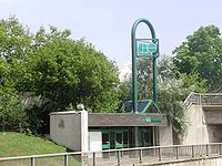 |
|
| CIBC 750 Lawrence CIBC 750 Lawrence CIBC 750 Lawrence is a two tower complex in Toronto, Ontario, Canada, built in the early 1980s. It is part of CIBC's head office operations outside of Commerce Court and the main quarters of CIBC Credit Card Services, including Visa call centres. The Visa call centre is a member of the Steel... |
Dufferin | major computer centre | |
| Lawrence Square Shopping Centre Lawrence Square Shopping Centre The Lawrence Square Shopping Centre in Toronto, Canada, is one of the city's twenty largest malls. It is located on Lawrence Avenue West, west of Allen Road, in the neighbourhood of Lawrence Heights, which is in Yorkdale-Glen Park, and is readily accessible from the Toronto Transit Commission's... |
Allen Road | former RS Simpson Limited warehouse | 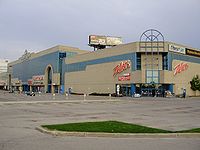 |
| Lawrence West subway station Lawrence West (TTC) Lawrence West is a station on the Yonge–University–Spadina line of the subway system in Toronto, Ontario, Canada. It is located on William R. Allen Road at 655 Lawrence Avenue West. It opened in 1978 in what was then the Borough of North York... |
Allen Road | ||
| Bathurst Heights Secondary School Bathurst Heights Secondary School Bathurst Heights Secondary School was a public high school located in the North York district of Toronto, and serving the area of Lawrence Avenue West and Allen Road . Bathurst Heights closed its doors on June 23rd 2001... |
Allen Road | ||
| Lawrence Plaza Lawrence Plaza Lawrence Plaza is a shopping centre in Canada located on the northwest corner of Bathurst Street and Lawrence Avenue West in Toronto.-History:It was built around 1953 and was visited by Queen Elizabeth II in the 1950s.... |
Bathurst | one of the earliest shopping plazas in Toronto | |
| Havergal College Havergal College Havergal College is an independent boarding and day school for girls from Junior Kindergarten to Grade 12 in Toronto, Ontario, Canada.Named for English hymn composer, author and humanitarian Frances Ridley Havergal, the school was founded in 1894 by a group of men led by The Honourable H... |
Avenue Road | Private girls school |  |
| Lawrence Park Collegiate Institute Lawrence Park Collegiate Institute Lawrence Park Collegiate Institute is a high school in the Lawrence Park neighbourhood of Toronto. It is a non-semestered school and focuses mainly on academics, drama, music, and visual arts, featuring strong French extended and immersion streams.... |
Avenue Road | 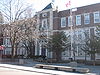 |
|
| Lawrence subway station Lawrence (TTC) Lawrence is a station on the Yonge–University–Spadina line of the subway system in Toronto, Ontario, Canada. It is located at 3101 Yonge Street at Lawrence Avenue.... |
Yonge | 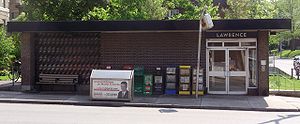 |
|
| Toronto French School Toronto French School The Toronto French School , founded in 1962 , is an independent, bilingual, co-educational, non-denominational school in midtown Toronto, Ontario, Canada. Elizabeth II, as Queen of Canada, is the royal patron of the school.... |
Bayview | 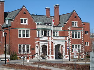 |
|
| Glendon College Glendon College Glendon College is one of the two campuses of York University, Canada's third-largest university, in Toronto, Ontario. A bilingual liberal arts college with 84 full-time faculty members and a student population of about 2400, Glendon is located in midtown Toronto's Lawrence Park neighbourhood... , York University York University York University is a public research university in Toronto, Ontario, Canada. It is Canada's third-largest university, Ontario's second-largest graduate school, and Canada's leading interdisciplinary university.... |
Bayview | 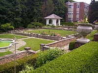 |
|
| Bridle Path Bridle Path, Toronto The Bridle Path upscale residential neighbourhood in the former city of North York, now part of Toronto, Ontario, Canada, that is characterized by large multi-million dollar mansions and two to four acre lot sizes. It is often referred to as "Millionaires' Row"... |
The Bridle Path | Toronto's wealthiest neighbourhood | 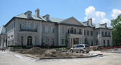 |
| Edwards Gardens Edwards Gardens Edwards Gardens is a botanical garden located on the southwest corner of Leslie Street and Lawrence Avenue East in Toronto, Ontario. It is also the site of the Toronto Botanical Garden, a private not-for profit organization previously called the Civic Garden Centre.It is a former estate garden... |
Leslie | 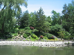 |
|
| Don Mills Centre Don Mills Centre The Don Mills Centre was a shopping centre in Toronto, Ontario, Canada. It was located on a 44-acre commercial site, at the southwest corner of Don Mills Road and Lawrence Avenue East in the planned community of Don Mills. There were at least 98 stores during the height of the mall's existence... |
Don Mills | ||
| Don Mills Collegiate Institute Don Mills Collegiate Institute Don Mills Collegiate Institute is a high school in the community of Don Mills in Toronto. It serves an ethnically diverse student population of approximately 1000. As of 2006, 66% of students speak a first language other than English... |
Don Mills | 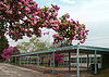 |
|
| Wexford Heights United Church | Warden | 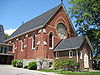 |
|
| St. Lawrence Martyr Catholic Church | Birchmount | 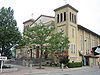 |
|
| Winston Churchill Collegiate Institute Winston Churchill Collegiate Institute Winston Churchill Collegiate Institute is a public high school in Scarborough, Toronto, Ontario. Although the language of instruction is English, 59 percent of the students do not use English as their primary language, and 26 percent have resided in Canada less than five years... |
Kennedy | 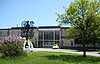 |
|
| Lawrence East RT station Lawrence East (TTC) Lawrence East is a station on the Scarborough Rapid Transit line of the subway/RT system in Toronto, Ontario, Canada. It is located at 2444 Lawrence Avenue East between Kennedy Road and Midland Avenue and opened in 1985.... |
Kennedy | 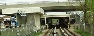 |
|
| David and Mary Thomson Collegiate Institute David and Mary Thomson Collegiate Institute David and Mary Thomson Collegiate Institute is an English-language high school located in Scarborough, Toronto, Ontario, Canada.-History:David and Mary Thomson C.I. was opened in September, 1959. This school is located in the heart of historical Scarborough. It was named after Scarborough's first... |
Midland | named after Scarborough's first European (Scottish Scotland Scotland is a country that is part of the United Kingdom. Occupying the northern third of the island of Great Britain, it shares a border with England to the south and is bounded by the North Sea to the east, the Atlantic Ocean to the north and west, and the North Channel and Irish Sea to the... ) born pioneer families |
 |
| Thomson Memorial Park Thomson Memorial Park Thomson Memorial Park is a mid size park in Scarborough, Ontario, and is the site of the Scarborough Historical Museum and includes historical houses of the founding family of the former city, the Thomson's, from the 1790s; more Thomson houses are found on the northern edge of the park on St.... |
Brimley | 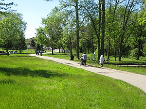 |
|
| The Scarborough Hospital | McCowan | ||
| St. Rose of Lima Catholic Church | McCowan |  |
|
| Cedarbrae Mall Cedarbrae Mall Cedarbrae Mall is a shopping mall in the Scarborough area of Toronto, Canada, at the corner of Markham Road and Lawrence Avenue. The mall opened in the early 1960s.-Notable tenants:... |
Markham | ||
| St. Stephen's Presbyterian Church | Scarborough Golf Club | ||
| Sir Oliver Mowat Collegiate Institute Sir Oliver Mowat Collegiate Institute Sir Oliver Mowat Collegiate Institute is a public high school located in Toronto, located in south east Scarborough. The school was built in 1969 and named for Sir Oliver Mowat, a Father of Confederation and former Ontario premier.... |
Centennial Rd | ||
| Rouge Hill GO Station | East Ave |