

Bayview Avenue
Encyclopedia
Greater Toronto Area
The Greater Toronto Area is the largest metropolitan area in Canada, with a 2006 census population of 5.5 million. The Greater Toronto Area is usually defined as the central city of Toronto, along with four regional municipalities surrounding it: Durham, Halton, Peel, and York...
of Ontario
Ontario
Ontario is a province of Canada, located in east-central Canada. It is Canada's most populous province and second largest in total area. It is home to the nation's most populous city, Toronto, and the nation's capital, Ottawa....
. North of Toronto
Toronto
Toronto is the provincial capital of Ontario and the largest city in Canada. It is located in Southern Ontario on the northwestern shore of Lake Ontario. A relatively modern city, Toronto's history dates back to the late-18th century, when its land was first purchased by the British monarchy from...
, in York Region, Bayview is also designated as York Regional Road 34.
History
Bayview Avenue follows the first concession line, laid 6600 ft (2,011.7 m) east of Yonge Street. Over time, the concession road became known as East York Avenue, a reference to the division it formed between the city of Toronto and the township of East York.In 1931, James Stanley McLean constructed Bay View overlooking the Don Valley on the edge of Moore Park
Moore Park, Toronto
Moore Park is a neighbourhood in Toronto, Ontario, Canada. It lies along both sides of St. Clair Avenue East between the Vale of Avoca section of Rosedale ravine and Moore Park ravine . The northern boundary is Mount Pleasant Cemetery and the southern the Canadian Pacific Railway tracks.The...
.
On August 17, 1959, Bayview was extended south from Moore Avenue in Leaside
Leaside
Leaside is a neighbourhood in Toronto, Ontario, Canada. The area takes its name from William Lea and the Lea family, who settled there in the early years of the nineteenth century. The area first developed as farmland along with Toronto through the nineteenth century. It was incorporated as a...
to Front Street
Front Street (Toronto)
Front Street is an east-west road in downtown Toronto, Ontario, Canada. The street marks the rough outline of the shoreline of Lake Ontario as it existed during the original English settlement of York, then called Palace Street...
. The northern section of this extension was routed alongside Pottery Road to Nesbitt Drive. South of this, it wraps around a hill and descends into the Lower Don Valley
Lower Don Valley
The Lower Don Valley, or historically the East End of Sheffield, is the mainly industrial north-east quarter of Sheffield, England. Based around the River Don it encompasses the areas of Attercliffe, Brightside, Darnall, Tinsley and Wincobank....
, travelling parallel to the route of the Don Valley Parkway
Don Valley Parkway
The Don Valley Parkway is a controlled-access six-lane municipal expressway in Toronto connecting the Gardiner Expressway in downtown Toronto with Ontario Highway 401, the Macdonald–Cartier Freeway. North of Highway 401, it continues as Ontario Highway 404. The parkway runs through...
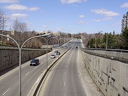
. This addition is frequently referred to as the Bayview Extension and is one of the few streets in Toronto with a speed limit of 70 km/h (43.5 mph).
In the late 1990s, York Region conducted several road needs studies near Lake Wilcox, which determined that the disjointed and disconnected Bayview Avenue should be connected from Stouffville Road in the south to Bloomington Road in the north. A lengthy battle ensued between environmentalists, upset over continuing construction in the supposedly protected Oak Ridges Moraine. The discovery of Jefferson Salamander
Jefferson Salamander
The Jefferson salamander is a mole salamander native to the northeastern United States, southern and central Ontario, and southwestern Quebec. It was named after Jefferson College in Pennsylvania....
s in the study area resulted in several modifications to the design of the route, including a 70 m (229.7 ft) structure over a dry ravine, as well as five amphibian tunnels. On November 17, 2002, the new extension was opened, including a widened intersection at Stouffville Road. The former route of Bayview was turned into several short streets which lie directly west of the new roadway.
Bayview Avenue was once proposed to be renamed Kilgour Avenue by the town of Leaside, after Joseph Kilgour, whose widow sold his farm, Sunnybrook, to the city of Toronto on the condition that it never be developed. Today, Sunnybrook Hospital and Sunnybrook Park
Sunnybrook Park
Sunnybrook Park is a large public park in Toronto, Ontario, Canada. It is located north of Leaside and south of the Bridle Path areas of the city.-Cricket:Sunnybrook hosted a first-class cricket fixture in 2004...
occupy those lands. While Bayview was never renamed, a recently constructed street south of the hospital carries the name Kilgour Road today.
Route description
The southern end of Bayview Avenue starts at River Street (under Queen Street East). For the first part of its route northward it runs through the Don Valley, on the east side of the river opposite the Don Valley ParkwayDon Valley Parkway
The Don Valley Parkway is a controlled-access six-lane municipal expressway in Toronto connecting the Gardiner Expressway in downtown Toronto with Ontario Highway 401, the Macdonald–Cartier Freeway. North of Highway 401, it continues as Ontario Highway 404. The parkway runs through...
. Along this stretch a steep cliff separates it from neighbourhoods such as Cabbagetown
Cabbagetown, Toronto
Cabbagetown is a neighbourhood located on the east side of downtown Toronto, Ontario, Canada. It comprises "the largest continuous area of preserved Victorian housing in all of North America", according to the Cabbagetown Preservation Association....
.
Bayview exits the Don Valley, passing through the Governor's Bridge neighbourhood and entering Leaside. It is the major commercial street for Leaside, home to many small shops and restaurants. North of Leaside Bayview runs across several tributaries of the Don River and is carried over one of them by the six-lane Bayview Bridge. This is the western portion of the wealthy Lawrence Park
Lawrence Park, Toronto
Lawrence Park is one of Toronto, Canada's most affluent residential neighbourhoods, along with Rosedale, the Bridle Path, and Forest Hill. It is also one of the wealthiest neighbourhoods in Canada....
neighbourhood, and just to the east is the Bridle Path
Bridle Path, Toronto
The Bridle Path upscale residential neighbourhood in the former city of North York, now part of Toronto, Ontario, Canada, that is characterized by large multi-million dollar mansions and two to four acre lot sizes. It is often referred to as "Millionaires' Row"...
, the single wealthiest area of Toronto. A number of major institutions are found in this area including Sunnybrook Health Sciences Centre
Sunnybrook Health Sciences Centre
Sunnybrook Health Sciences Centre, abbreviated SHSC and known simply as Sunnybrook, is an academic health sciences centre located in Toronto, Ontario....
, Glendon College
Glendon College
Glendon College is one of the two campuses of York University, Canada's third-largest university, in Toronto, Ontario. A bilingual liberal arts college with 84 full-time faculty members and a student population of about 2400, Glendon is located in midtown Toronto's Lawrence Park neighbourhood...
, Toronto French School
Toronto French School
The Toronto French School , founded in 1962 , is an independent, bilingual, co-educational, non-denominational school in midtown Toronto, Ontario, Canada. Elizabeth II, as Queen of Canada, is the royal patron of the school....
, The Granite Club
The Granite Club
The Granite Club is an invitation-only athletic country club in Toronto. Founded in 1836, it is one of Canada's most prestigious private athletic clubs....
, The Crescent School, and the Bob Rumball Centre for the Deaf.
North of York Mills Avenue Bayview becomes one of the major north-south arterials for suburban North York. It passes through the neighbourhoods of Bayview Village
Bayview Village
Bayview Village is an affluent neighbourhood in Toronto, Ontario, Canada, formerly in North York before it was amalgamated into Toronto in 1998. It is part of the federal and provincial electoral district Willowdale, and Toronto electoral wards 24: Willowdale and 33: Don Valley North...
, Bayview Woods, Willowdale
Willowdale, Toronto
Willowdale is an established, affluent community in the city of Toronto, Ontario, Canada, located in the district of North York. It was originally called Lansing, which is now the name of a nearby neighbourhood....
, and Newtonbrook.
It runs north beyond Steeles Avenue
Steeles Avenue
Steeles Avenue is an east-west street that forms the northern city limit of Toronto and the southern limit of York Region, Ontario, Canada. It stretches across the western Greater Toronto Area from Milborough Townline in Halton Region east to the Scarborough-Pickering limit. It runs for within...
, Toronto’s northern city limit, and continues north through York Region, where it is formally identified as York Regional Road 34. It is one of the main arterial roads for Thornhill
Thornhill, Ontario
Thornhill is a community in the Greater Toronto Area of Southern Ontario, Canada, located on the northern border of the city of Toronto. Once a municipal village, Thornhill is now a community and postal designation geographically split into two municipalities along Yonge Street, the city of...
and Richmond Hill
Richmond Hill, Ontario
Richmond Hill is a town located in Southern Ontario, Canada in the central portion of York Region, Ontario. It is part of the Greater Toronto Area, being located about halfway between Toronto and Lake Simcoe...
. It then passes through the Oak Ridges Moraine
Oak Ridges Moraine
The Oak Ridges Moraine is an ecologically important geological landform in the Mixedwood Plains of south-central Ontario, Canada. The moraine covers a geographic area of between Caledon and Rice Lake, near Peterborough...
, passing a number of parks and conservation areas. North of the moraine the street again enters urban areas, passing through Aurora
Aurora, Ontario
Aurora is an affluent town in York Region, approximately 20 km north of Toronto. It is partially situated on the Oak Ridges Moraine, and is a part of the Greater Toronto Area and Golden Horseshoe of Southern Ontario.Many Aurora residents commute to Toronto and surrounding communities.In the...
and Newmarket
Newmarket, Ontario
Newmarket is a town in Southern Ontario located approximately 50 km north of downtown Toronto, Ontario, Canada. It is part of the Greater Toronto Area and is connected to Toronto by freeway, and is served by three interchanges along Highway 404. It is also connected to Highway 400 via Highway 9...
. It ends in Newmarket where it turns into Prospect Street.
Bayview Avenue is also home to major places of worship of almost every major religious tradition including synagogue
Synagogue
A synagogue is a Jewish house of prayer. This use of the Greek term synagogue originates in the Septuagint where it sometimes translates the Hebrew word for assembly, kahal...
s, an Islam
Islam
Islam . The most common are and . : Arabic pronunciation varies regionally. The first vowel ranges from ~~. The second vowel ranges from ~~~...
ic mosque
Mosque
A mosque is a place of worship for followers of Islam. The word is likely to have entered the English language through French , from Portuguese , from Spanish , and from Berber , ultimately originating in — . The Arabic word masjid literally means a place of prostration...
, the city’s largest evangelical
Evangelism
Evangelism refers to the practice of relaying information about a particular set of beliefs to others who do not hold those beliefs. The term is often used in reference to Christianity....
churches, Canada’s largest Buddhist
Buddhism
Buddhism is a religion and philosophy encompassing a variety of traditions, beliefs and practices, largely based on teachings attributed to Siddhartha Gautama, commonly known as the Buddha . The Buddha lived and taught in the northeastern Indian subcontinent some time between the 6th and 4th...
Temple, Toronto’s largest Eastern Orthodox cathedral, and Canada’s only Zoroastrian
Zoroastrianism
Zoroastrianism is a religion and philosophy based on the teachings of prophet Zoroaster and was formerly among the world's largest religions. It was probably founded some time before the 6th century BCE in Greater Iran.In Zoroastrianism, the Creator Ahura Mazda is all good, and no evil...
Temple. These can all be found along a 15-kilometre section of the road.
Transit
The southern part of Bayview has no transit service, but runs parallel to the Richmond Hill GO Transit lineRichmond Hill Line
The Richmond Hill Line is a surface transit line on Myrtle Avenue in Queens, New York City, United States. Once a streetcar line owned by the Brooklyn–Manhattan Transit Corporation, it is now the Q55 Myrtle Avenue bus route, operated by the New York City Transit Authority....
. In Leaside the 11 Bayview bus route begins, connecting to the subway at Davisville Station. The 11 runs north to Steeles Avenue. At Sheppard Avenue it connects with the Bayview Station
Bayview (TTC)
Bayview is a station on the Sheppard line of the subway system in Toronto, Ontario, Canada. It is located at 550 Sheppard Avenue East, at Bayview Avenue. It opened in 2002.- Architecture and art :Stevens Group Architects designed the station...
on the Sheppard Line.
In York Region the 91 Bayview runs from Steeles to Lake Wilcox
Lake Wilcox
Wilcox Lake is both a kettle lake and a community within Oak Ridges, Richmond Hill, Ontario, Canada. The lake measures 1.5 kilometers across and covers 55.6 hectares, making it the largest kettle lake on the Oak Ridges Moraine. Lake Wilcox, Lake St. George and their associated wetlands...
. The 54 Bayview then serves the street through Newmarket
Newmarket, Ontario
Newmarket is a town in Southern Ontario located approximately 50 km north of downtown Toronto, Ontario, Canada. It is part of the Greater Toronto Area and is connected to Toronto by freeway, and is served by three interchanges along Highway 404. It is also connected to Highway 400 via Highway 9...
and Aurora
Aurora, Ontario
Aurora is an affluent town in York Region, approximately 20 km north of Toronto. It is partially situated on the Oak Ridges Moraine, and is a part of the Greater Toronto Area and Golden Horseshoe of Southern Ontario.Many Aurora residents commute to Toronto and surrounding communities.In the...
.
Landmarks
| Landmark | Cross street | Notes | Image |
|---|---|---|---|
| Queen Street Viaduct | Queen St E |  |
|
| Prince Edward Viaduct Prince Edward Viaduct The Prince Edward Viaduct System, commonly referred to as the Bloor Viaduct or the viaduct, is the name of a truss arch bridge system in Toronto, Ontario, Canada that connects Bloor Street East, on the west side of the system, with Danforth Avenue on the east... |
Bloor St | Bayview runs under the viaduct | |
| Don Valley Brick Works Don Valley Brick Works The Don Valley Brick Works also known as Evergreen Brickworks is a former quarry and industrial site located in the Don River valley in Toronto, Ontario. Currently the buildings sit mostly unused while the quarry has been converted into a city park which includes a series of naturalized ponds... |
Pottery Road | 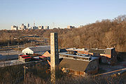 |
|
| Crothers' Woods Crothers' Woods Crothers' Woods is an area of the Don River valley in Toronto, Ontario, Canada. It is approximately 25 ha in size and consists of woodland, meadows, wetlands, and an assortment of past and present municipal uses. The wooded area has been designated as an Environmentally Significant Area by the... |
Nesbitt Dr | 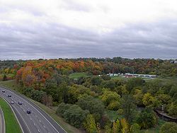 |
|
| Mount Pleasant Cemetery Mount Pleasant Cemetery, Toronto Mount Pleasant Cemetery is a cemetery located in Toronto, Ontario, Canada.In the early 19th century, the only authorized cemeteries within the city of Toronto were limited to the members of either the Roman Catholic Church or the Church of England... |
Moore Ave | Bayview forms the eastern boundary of Canada's largest cemetery | |
| St Cuthbert's Anglican Church | McRae Dr | 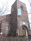 |
|
| St. Augustine of Canterbury Anglican | Broadway Ave | 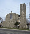 |
|
| Mount Hope Catholic Cemetery Mount Hope Catholic Cemetery Mount Hope Catholic Cemetery at 305 Erskine Avenue in Toronto, Ontario, Canada was consecrated on July 9, 1898 by Roman Catholic Archbishop John Walsh. The first burial occurred on March 27, 1900. By the end of the 20th Century, the cemetery was full, holding the remains of more than 76,000 persons... |
Kilgour Rd | ||
| Sunnybrook Health Sciences Centre Sunnybrook Health Sciences Centre Sunnybrook Health Sciences Centre, abbreviated SHSC and known simply as Sunnybrook, is an academic health sciences centre located in Toronto, Ontario.... |
Blythwood Rd | ||
| Lawrence Park Community Church | Dawlish Ave | ||
| Glendon College Glendon College Glendon College is one of the two campuses of York University, Canada's third-largest university, in Toronto, Ontario. A bilingual liberal arts college with 84 full-time faculty members and a student population of about 2400, Glendon is located in midtown Toronto's Lawrence Park neighbourhood... |
Lawrence Ave E | Campus of York University York University York University is a public research university in Toronto, Ontario, Canada. It is Canada's third-largest university, Ontario's second-largest graduate school, and Canada's leading interdisciplinary university.... |
 |
| Toronto French School Toronto French School The Toronto French School , founded in 1962 , is an independent, bilingual, co-educational, non-denominational school in midtown Toronto, Ontario, Canada. Elizabeth II, as Queen of Canada, is the royal patron of the school.... |
Lawrence Ave E | 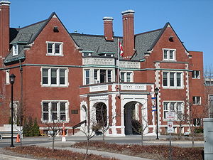 |
|
| Bayview Bridge | Lawrence Ave E | Carries Bayview across the Don Valley | 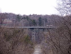 |
| The Granite Club The Granite Club The Granite Club is an invitation-only athletic country club in Toronto. Founded in 1836, it is one of Canada's most prestigious private athletic clubs.... |
Lawrence Ave E | ||
| The Crescent School | Lawrence Ave E | ||
| Bob Rumball Centre for the Deaf | Lawrence Ave E | ||
| Trinity York Mills Presbyterian Church | Highway 401 | ||
| Bayview Station Bayview (TTC) Bayview is a station on the Sheppard line of the subway system in Toronto, Ontario, Canada. It is located at 550 Sheppard Avenue East, at Bayview Avenue. It opened in 2002.- Architecture and art :Stevens Group Architects designed the station... |
Sheppard Ave | On the Sheppard line | |
| Bayview Village Shopping Centre Bayview Village Shopping Centre Bayview Village Shopping Centre is an upscale shopping mall in the North York area of Toronto, Ontario, Canada, catering to affluent customers and containing over 110 stores. The shopping mall is located at Bayview Avenue and Sheppard Avenue in the community of Willowdale, and neighbourhood of... |
Sheppard Ave | ||
| United Synagogue Day School United Synagogue Day School United Synagogue Day School is a private elementary and middle school Jewish day school in Toronto, Ontario.... |
Mckee Ave | ||
| St. Joseph's Morrow Park Catholic Secondary School St. Joseph's Morrow Park Catholic Secondary School St. Joseph's Morrow Park is an all-girls secondary school located in Toronto, Ontario. It was founded by the Sisters of St. Joseph in 1960 and is attached to the Sisters' motherhouse at Morrow Park... |
Cumner Ave | ||
| Shouldice Hernia Centre Shouldice Hernia Centre Shouldice Hernia Centre is a hospital in Thornhill, Ontario, Canada, that is known for its specialization in external abdominal hernia operations. Shouldice uses a natural tissue, tension free, technique developed during World War II by Dr. Edward Earle Shouldice. Their ten full-time surgeons... |
John St | ||
| Thornlea Secondary School Thornlea Secondary School Thornlea Secondary School is a public high school that opened in 1968 and is located in Thornhill, Ontario, Canada, on the north east corner Bayview Avenue and Willowbrook Road, just south of Highway 407.... |
Willowbrook Rd | ||
| Toronto Montessori Schools Toronto Montessori Schools Toronto Montessori Schools, now rebranded to "TMS School", was the first Montessori school in Canada. Founded by Helma Trass in 1961, it still remains the most well-known Montessori school in Ontario. The school is now expanded into a high school and includes students from 18 months to grade 12. ... |
Highway 7 | ||
| Bayview Secondary School Bayview Secondary School Bayview Secondary School is a 9–12, 2-semester high school under the York Region District School Board. It is located just north of the northeast corner of Bayview Avenue and Major Mackenzie Drive in the Town of Richmond Hill, Ontario, Canada.... |
Major Mackenzie Dr | ||
| Holy Trinity School Holy Trinity School (Richmond Hill) Holy Trinity School is a private, co-educational, university preparatory institution located in Richmond Hill, Ontario affiliated with the Anglican Church of Canada. There are approximately 800 students currently enrolled from junior kindergarten to grade 12... |
19th Ave | ||
| Wilcox Lake | Bethesda Side Road | ||
| Pickering College Pickering College Pickering College is an independent, co-educational school for children in grades from Junior Kindergarten through grade 12. It is located in Newmarket, Ontario in Canada on a 17-hectare property on Bayview Avenue... |
Mullock Dr |