
Mount Bromo
Encyclopedia
- For the main article that includes the Sand Sea and the Mount Semeru area, see Bromo Tengger Semeru National ParkBromo Tengger Semeru National ParkBromo Tengger Semeru National Park is located in East Java, Indonesia, to the east of Malang and to the southeast of Surabaya, the capital of East Java. It is the only conservation area in Indonesia that has a sand sea, the Tengger Sand Sea , across which is the caldera of an ancient volcano from...
.
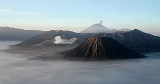
Mount Bromo , is an active volcano
Volcano
2. Bedrock3. Conduit 4. Base5. Sill6. Dike7. Layers of ash emitted by the volcano8. Flank| 9. Layers of lava emitted by the volcano10. Throat11. Parasitic cone12. Lava flow13. Vent14. Crater15...
and part of the Tengger massif, in East Java
East Java
East Java is a province of Indonesia. It is located on the eastern part of the island of Java and includes neighboring Madura and islands to its east and to its north East Java is a province of Indonesia. It is located on the eastern part of the island of Java and includes neighboring Madura and...
, Indonesia
Indonesia
Indonesia , officially the Republic of Indonesia , is a country in Southeast Asia and Oceania. Indonesia is an archipelago comprising approximately 13,000 islands. It has 33 provinces with over 238 million people, and is the world's fourth most populous country. Indonesia is a republic, with an...
. At 2329 metres (7,641 ft) it is not the highest peak of the massif, but is the most well known. The massif area is one of the most visited tourist attractions in East Java
East Java
East Java is a province of Indonesia. It is located on the eastern part of the island of Java and includes neighboring Madura and islands to its east and to its north East Java is a province of Indonesia. It is located on the eastern part of the island of Java and includes neighboring Madura and...
, Indonesia
Indonesia
Indonesia , officially the Republic of Indonesia , is a country in Southeast Asia and Oceania. Indonesia is an archipelago comprising approximately 13,000 islands. It has 33 provinces with over 238 million people, and is the world's fourth most populous country. Indonesia is a republic, with an...
. The volcano belongs to the Bromo Tengger Semeru National Park
Bromo Tengger Semeru National Park
Bromo Tengger Semeru National Park is located in East Java, Indonesia, to the east of Malang and to the southeast of Surabaya, the capital of East Java. It is the only conservation area in Indonesia that has a sand sea, the Tengger Sand Sea , across which is the caldera of an ancient volcano from...
. The name of Bromo derived from Javanese
Javanese language
Javanese language is the language of the Javanese people from the central and eastern parts of the island of Java, in Indonesia. In addition, there are also some pockets of Javanese speakers in the northern coast of western Java...
pronunciation of Brahma
Brahma
Brahma is the Hindu god of creation and one of the Trimurti, the others being Vishnu and Shiva. According to the Brahma Purana, he is the father of Mānu, and from Mānu all human beings are descended. In the Ramayana and the...
, the Hindu
Hindu
Hindu refers to an identity associated with the philosophical, religious and cultural systems that are indigenous to the Indian subcontinent. As used in the Constitution of India, the word "Hindu" is also attributed to all persons professing any Indian religion...
creator god.
Mount Bromo sits in the middle of a vast plain called the "Sea of Sand" ( or ), a protected nature reserve since 1919. The typical way to visit Mount Bromo is from the nearby mountain village of Cemoro Lawang
Cemoro Lawang
Cemoro Lawang is a very small town in the top of a hill to the north-east of the Mount Bromo , Indonesia....
. From there it is possible to walk to the volcano in about 45 minutes, but it is also possible to take an organised jeep tour, which includes a stop at the viewpoint on Mount Penanjakan (2770 m or 9,088 ft) . The best views from Mount Bromo to the Sand Sea below and the surrounding volcanoes are at sunrise. The viewpoint on Mount Penanjakan can also be reached on foot in about two hours. From inside the caldera
Caldera
A caldera is a cauldron-like volcanic feature usually formed by the collapse of land following a volcanic eruption, such as the one at Yellowstone National Park in the US. They are sometimes confused with volcanic craters...
, sulfur
Sulfur
Sulfur or sulphur is the chemical element with atomic number 16. In the periodic table it is represented by the symbol S. It is an abundant, multivalent non-metal. Under normal conditions, sulfur atoms form cyclic octatomic molecules with chemical formula S8. Elemental sulfur is a bright yellow...
is collected by workers.
Depending on the degree of volcanic activity, the Indonesian Centre for Vulcanology and Disaster Hazard Mitigation sometimes issues warnings against visiting Mount Bromo. The list of outstanding warnings may be consulted at the Indonesian-language website of the Centre.
Culture
On the fourteenth day of the Hindu festival of Yadnya Kasada, the TenggereseTenggerese
The Tenggerese are the descendants of the Majapahit princes. Their population of roughly 600,000 is centered in thirty villages in the isolated Tengger mountains within the Bromo Tengger Semeru National Park in East-Central Java....
people of Probolinggo, East Java, travel up the mountain in order to make offerings of fruit, rice, vegetables, flowers and sacrifices of livestock to the mountain gods by throwing them into the caldera
Caldera
A caldera is a cauldron-like volcanic feature usually formed by the collapse of land following a volcanic eruption, such as the one at Yellowstone National Park in the US. They are sometimes confused with volcanic craters...
of the volcano
Volcano
2. Bedrock3. Conduit 4. Base5. Sill6. Dike7. Layers of ash emitted by the volcano8. Flank| 9. Layers of lava emitted by the volcano10. Throat11. Parasitic cone12. Lava flow13. Vent14. Crater15...
. The origin of the ritual lies in the 15th century legend where a princess named Roro Anteng started the principality of Tengger with her husband, Joko Seger. The couple were childless and therefore beseeched the assistance of the mountain gods. The gods granted them 24 children but stipulated that the 25th child, named Kesuma, must be thrown into the volcano as human sacrifice. The gods' request was implemented. The tradition of throwing sacrifices into the volcano to appease these ancient deities continues today and called Yadnya Kasada ceremony. Though fraught with danger, some locals risk climbing down into the crater in an attempt to recollect the sacrificed goods that believed could bring them good luck.
On the Segara Wedi sand plain sits a Hindu
Hindu
Hindu refers to an identity associated with the philosophical, religious and cultural systems that are indigenous to the Indian subcontinent. As used in the Constitution of India, the word "Hindu" is also attributed to all persons professing any Indian religion...
temple called Pura Luhur Poten. The temple holds a significant importance to the Tenggerese scatter across the mountainous villages such as Ngadisari, Wonokitri, Ngadas, Argosari, Ranu Prani, Ledok Ombo and Wonokerso. The temple organized annual Yadnya Kasada ceremony which lasts for about one month. On the 14th day, the Tenggerese will congregate at Pura Luhur Poten to ask for blessings from Ida Sang Hyang Widi Wasa and God of Mahameru (Mount Semeru). Then the mass will proceed along the crater edges of Mt Bromo where offerings will be thrown into the crater. The major difference between this temple with the Balinese ones are the type of stones and building materials. Pura Luhur Poten uses natural black stones from volcanoes nearby, while Balinese temples mostly made from red bricks. Inside this pura, there are several buildings and enclosures aligned in Mandala zone composition.
2004 eruptions
Mount Bromo erupted in 2004, that eruptive episode led to the death of two people.2010 eruptions
On Tuesday, 23 November 2010, 16.30 WIB (Western Indonesian Time), the Indonesian Centre of Vulcanology and Geology Hazard Mitigation (CVGHM) confirmed the activity status of Mount Bromo at "alert" due to increasing tremor activity and shallow volcanic earthquakes at the mountain. Concerns were raised that a volcanic eruption may be likely to occur. As a precaution local residents and tourists were instructed to remain clear of an area within radius three kilometres from the caldera and refugee encampments were erected. The area surrounding the Teggera caldera of Bromo remained off limits for visitors throughout the remaining part of 2010.Bromo started to erupt ash on Friday 26 November 2010.
On 29 November 2010 Transport Ministry
Directorate General of Civil Aviation Republic of Indonesia
The Directorate General of Civil Aviation of the Republic of Indonesia has responsibility for the administration of civil aviation throughout the nation of Indonesia...
spokesman Bambang Ervan announced that Malang's
Malang
Malang is the second largest city in East Java province, Indonesia. It has an ancient history dating back to the Mataram Kingdom. The city population at the 2010 Census was 819,708. During the period of Dutch colonization, it was a popular destination for European residents. The city is famous for...
domestic airport, would be closed until 4 December 2010. Malang a city of about 800,000 people is about 25 km (16 mi) west of Mount Bromo. Abdul Rachman Saleh Airport
Abdul Rachman Saleh Airport
Abdul Rachman Saleh Airport is an airport serving Malang, the second largest city in East Java province of Indonesia. This airport is named after Abdoel Rachman Saleh, an Indonesian aviator and physiologist whose plane was shot down by the Dutch when landing in Maguwo Airfield , Sleman Regency,...
IATA:MLG normally handles 10 daily domestic flights from the capital Jakarta
Jakarta
Jakarta is the capital and largest city of Indonesia. Officially known as the Special Capital Territory of Jakarta, it is located on the northwest coast of Java, has an area of , and a population of 9,580,000. Jakarta is the country's economic, cultural and political centre...
. Government volcanologist Surono reported that the volcano was spitting columns of ash some 700 metres (2,300 feet) into the sky.
2011 eruptions
The Tengger Caldera was still active in late January 2011, the activity being characterised by fluctuating ongoing eruptions. On 23 January 2011 the Indonesian Centre for Volcanology and Geological Hazard Mitigation (CVGHM) (Pusat Vulkanologi dan Mitigasi Bencana Geologi) reported that since 19 December, 2010 volcanic ash and incandescent material had been thrown up by eruptive activity resulting in a heavy rain of material that fell around the crater. Continuous eruptions on 21 January caused a thin ash fall mainly in the village areas of Ngadirejo and Sukapura Wonokerto in Probolinggo district. The impact of a heavy rain of volcanic ash from eruptions since 19 December 2010 resulted in disruption of normal activities. By early 2011 concerns were being raised concerning the effect upon the local economy and the potential for long term environmental and health problems amongst the residents in the locality surrounding Mount Bromo. Due to high seasonal rainfall in January 2011 the potential for laharLahar
A lahar is a type of mudflow or debris flow composed of a slurry of pyroclastic material, rocky debris, and water. The material flows down from a volcano, typically along a river valley. The term is a shortened version of "berlahar" which originated in the Javanese language of...
and lava flow was raised due to the deposits of volcanic ash, sand and other ejected material that had built up. Seismic activity was dominated by tremor vibration and reports of visual intensity and sounds of eruption continued to be reported from the mountain monitoring facility, Bromo Observation Post. People living on the banks of the Perahu Ravine, Nganten Ravine and Sukapura River were alerted to the possibility of lava flows, especially when it was raining heavily in the area around Cemorolawang, Ngadisari and Ngadirejo. Eruptions and volcanic tremors were reported on 21 January and 22 January with activity subsiding on 23 January 2011. On 23 January, 2011 at 06:00 am the alert status at Mount Bromo remained at (Level III).
On 23 January 2011 an exclusion zone was recommended for communities living around Mount Bromo. Tourists and hikers were to advised not to come within a radius of 2 km from the active crater. CVGHM stated that they expected warning signs to be installed stating the limit radius of 2 km from the crater. Operational caution was recommended for flights into and leaving Juanda International Airport
Juanda International Airport
Juanda International Airport , is an airport located in Sidoarjo, a small town near Surabaya, East Java. This airport serves Surabaya and surrounding areas. Juanda International Airport is operated by PT Angkasa Pura I. The airport takes its name after Djuanda Kartawidjaja, the last Prime Minister...
IATA:SUB in Surabaya
Surabaya
Surabaya is Indonesia's second-largest city with a population of over 2.7 million , and the capital of the province of East Java...
. CVGHM recommended the establishment of public areas for the provision of face masks and eye protection. CVGHM also issued a warning to residents to be cautious of ash build up on roofs and other places that may give cause for collapse under the burden of ash.
Further eruptions and the issuing of Aviation Ash advisories on 27 January and 28 January 2011 led to concerns being raised regarding a volcanic ash plume, reported to be drifting eastward toward the air corridors used to access the Ngurah Rai International Airport IATA:DPS in Bali
Bali
Bali is an Indonesian island located in the westernmost end of the Lesser Sunda Islands, lying between Java to the west and Lombok to the east...
. Airport official Sherly Yunita was reported at the time as stating that concerns about visibility had prompted Singapore Airlines
Singapore Airlines
Singapore Airlines Limited is the flag carrier airline of Singapore. Singapore Airlines operates a hub at Changi Airport and has a strong presence in the Southeast Asia, East Asia, South Asia, and "Kangaroo Route" markets...
, Jetstar-ValueAir, Air France-KLM
Air France-KLM
Air France-KLM is a European airline holding company incorporated under French law with its headquarters at Paris-Charles de Gaulle Airport in Tremblay-en-France, Paris...
, Virgin Blue and Cathay Pacific
Cathay Pacific
Cathay Pacific is the flag carrier of Hong Kong, with its head office and main hub located at Hong Kong International Airport, although the airline's registered office is on the 33rd floor of One Pacific Place...
to cancel several flights to Bali, 340 km (210 mi) to the east. SilkAir
SilkAir
SilkAir Private Limited is an airline based in Singapore. It is a wholly owned subsidiary of Singapore Airlines and operates scheduled passenger services from Singapore to 31 cities in Southeast Asia, South Asia and China. It has its head office on the fifth storey of SIA Superhub 1...
also cancelled flights on the 27 January between Singapore
Singapore
Singapore , officially the Republic of Singapore, is a Southeast Asian city-state off the southern tip of the Malay Peninsula, north of the equator. An island country made up of 63 islands, it is separated from Malaysia by the Straits of Johor to its north and from Indonesia's Riau Islands by the...
and Lombok
Lombok
Lombok is an island in West Nusa Tenggara province, Indonesia. It forms part of the chain of the Lesser Sunda Islands, with the Lombok Strait separating it from Bali to the west and the Alas Strait between it and Sumbawa to the east...
, an island to the east of Bali
Bali
Bali is an Indonesian island located in the westernmost end of the Lesser Sunda Islands, lying between Java to the west and Lombok to the east...
. The Volcanic Ash Advisory Centre
Volcanic Ash Advisory Center
A Volcanic Ash Advisory Center is a group of experts responsible for coordinating and disseminating information on atmospheric volcanic ash clouds that may endanger aviation. As of 2010, there are nine Volcanic Ash Advisory Centers located around the world, each one focusing on a particular...
in Darwin
Darwin, Northern Territory
Darwin is the capital city of the Northern Territory, Australia. Situated on the Timor Sea, Darwin has a population of 127,500, making it by far the largest and most populated city in the sparsely populated Northern Territory, but the least populous of all Australia's capital cities...
, Australia
Australia
Australia , officially the Commonwealth of Australia, is a country in the Southern Hemisphere comprising the mainland of the Australian continent, the island of Tasmania, and numerous smaller islands in the Indian and Pacific Oceans. It is the world's sixth-largest country by total area...
released several Code Red Aviation Ash Advisories pertaining to Mount Bromo (Tengger Caldera), on 27 January. They indicated that ash was observed at altitudes up to 18,000 ft (FL180) extending 200 nautical mi to the south east of the caldera. In other ash advisories of that day the cloud was reported as at times having a 10 km/h drift, both to the east, and to the south east.
Deformation-late November 2010-late January 2011
- Tiltmeter
- The Indonesian Centre for Volcanology and Geological Hazard Mitigation (CVGHM) reported on 13 January 2011, that deformation using tiltmeterTiltmeterA tiltmeter is an instrument designed to measure very small changes from the horizontal level, either on the ground or in structures. A similar term, in less common usage, is the inclinometer...
measurements indicated an inflation at rate of 5 micro radians between 25 November 2010 and 14 December 2010 and a relatively stable since 15 December, 2010 both on Radial Components and Tangential Components.
- Deformation measurement using EDMEDMEDM may also refer to:In information technology:* Electronic direct marketing, another term for E-mail marketing* Electronic Direct Mail*Electronic document management, the tracking and storage of electronic documents...
compared observations at designated measuring points; POS-BRO, POS-KUR and POS-BAT during the period 25 November 2010 - 20 December 2010 with observations from the period 21 December 2010 - 30 December 2010 indicated the shortening of the distance from the POS-BAT, or inflation. Observations between 30 December 2010 to 23 January 2011 were reported as relatively stable.
External links
- Villagers use sarongs to catch offerings thrown by Hindu worshipers into the crater of Mount Bromo from The Daily TelegraphThe Daily TelegraphThe Daily Telegraph is a daily morning broadsheet newspaper distributed throughout the United Kingdom and internationally. The newspaper was founded by Arthur B...