
Volcanic Ash Advisory Center
Overview
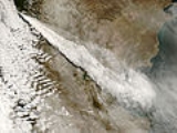
Volcanic ash
Volcanic ash consists of small tephra, which are bits of pulverized rock and glass created by volcanic eruptions, less than in diameter. There are three mechanisms of volcanic ash formation: gas release under decompression causing magmatic eruptions; thermal contraction from chilling on contact...
clouds that may endanger aviation
Aviation
Aviation is the design, development, production, operation, and use of aircraft, especially heavier-than-air aircraft. Aviation is derived from avis, the Latin word for bird.-History:...
. As of 2010, there are nine Volcanic Ash Advisory Centers located around the world, each one focusing on a particular geographical region. Their analyses are made public in the form of Volcanic Ash Advisories (VAA) and often incorporate the results of computer simulation models called Volcanic Ash Transport and Dispersion (VATD).
The worldwide network of Volcanic Ash Advisory Centers was set up by the International Civil Aviation Organisation (ICAO), an agency of the United Nations
United Nations
The United Nations is an international organization whose stated aims are facilitating cooperation in international law, international security, economic development, social progress, human rights, and achievement of world peace...
, as part of the International Airways Volcano Watch (IAVW), an international monitoring system managed by the International Airways Volcano Watch Operations Group (IAVWOPSG) which replaced the Volcanic Ash Warnings Study Group (VAWSG).