

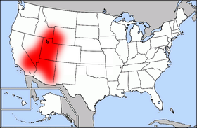
Mormon Corridor
Encyclopedia
North America
North America is a continent wholly within the Northern Hemisphere and almost wholly within the Western Hemisphere. It is also considered a northern subcontinent of the Americas...
that were settled between 1850 and approximately 1890 by members of The Church of Jesus Christ of Latter-day Saints (LDS Church), who are commonly known as Mormon
Mormon
The term Mormon most commonly denotes an adherent, practitioner, follower, or constituent of Mormonism, which is the largest branch of the Latter Day Saint movement in restorationist Christianity...
s.
In academic literature, the area is also commonly called the "Mormon culture region." It has also been referred to as the "Book of Mormon belt" as a cultural reference to the Bible Belt
Bible Belt
Bible Belt is an informal term for a region in the southeastern and south-central United States in which socially conservative evangelical Protestantism is a significant part of the culture and Christian church attendance across the denominations is generally higher than the nation's average.The...
of the southeastern United States, and the Book of Mormon
Book of Mormon
The Book of Mormon is a sacred text of the Latter Day Saint movement that adherents believe contains writings of ancient prophets who lived on the American continent from approximately 2600 BC to AD 421. It was first published in March 1830 by Joseph Smith, Jr...
.
Location
Beginning in UtahUtah
Utah is a state in the Western United States. It was the 45th state to join the Union, on January 4, 1896. Approximately 80% of Utah's 2,763,885 people live along the Wasatch Front, centering on Salt Lake City. This leaves vast expanses of the state nearly uninhabited, making the population the...
, the corridor extends northward through western Wyoming
Wyoming
Wyoming is a state in the mountain region of the Western United States. The western two thirds of the state is covered mostly with the mountain ranges and rangelands in the foothills of the Eastern Rocky Mountains, while the eastern third of the state is high elevation prairie known as the High...
and eastern Idaho
Idaho
Idaho is a state in the Rocky Mountain area of the United States. The state's largest city and capital is Boise. Residents are called "Idahoans". Idaho was admitted to the Union on July 3, 1890, as the 43rd state....
to Yellowstone National Park and reaches south to San Bernardino, California
San Bernardino, California
San Bernardino is a city located in the Riverside-San Bernardino metropolitan area , and serves as the county seat of San Bernardino County, California, United States...
on the west and through Mesa, Arizona
Mesa, Arizona
According to the 2010 Census, the racial composition of Mesa was as follows:* White: 77.1% * Hispanic or Latino : 26.54%* Black or African American: 3.5%* Two or more races: 3.4%* Native American: 2.4%...
on the east, extending to the U.S.-Mexico border. Settlements in Utah
Utah
Utah is a state in the Western United States. It was the 45th state to join the Union, on January 4, 1896. Approximately 80% of Utah's 2,763,885 people live along the Wasatch Front, centering on Salt Lake City. This leaves vast expanses of the state nearly uninhabited, making the population the...
south of the Wasatch Front
Wasatch Front
The Wasatch Front is a metropolitan region in the north-central part of the U.S. state of Utah. It consists of a chain of cities and towns stretched along the Wasatch Range from approximately Santaquin in the south to Brigham City in the north...
stretched from St. George
St. George, Utah
St. George is a city located in the southwestern part of the U.S. state of Utah, and the county seat of Washington County, Utah. It is the principal city of and is included in the St. George, Utah, Metropolitan Statistical Area. The city is 119 miles northeast of Las Vegas, Nevada, and 303 miles ...
in the southwest to Nephi
Nephi, Utah
Nephi is a city in Juab County, Utah, United States. It is part of the Provo–Orem, Utah Metropolitan Statistical Area. The population was 4,733 at the 2000 census. It is the county seat of Juab County. It was settled by Mormon pioneers in 1851, and is the principal city in Juab Valley, an...
in the northeast and including the Sevier River
Sevier River
The Sevier River , extending , is the longest Utah river entirely in the state and drains an extended chain of mountain farming valleys to the intermittent Sevier Lake...
valley, the corridor is roughly congruent with the area between present-day Interstate 15 and U.S. Route 89. Most of the population of the state that is not along the Wasatch Front
Wasatch Front
The Wasatch Front is a metropolitan region in the north-central part of the U.S. state of Utah. It consists of a chain of cities and towns stretched along the Wasatch Range from approximately Santaquin in the south to Brigham City in the north...
or in Utah's Cache Valley
Cache Valley
The Cache Valley is an agricultural valley of northern Utah and southeast Idaho that includes the Logan metropolitan area. The valley was used by 19th century mountain men and was the site of the 1863 Bear River Massacre.-History:...
resides in this corridor. Outside the Western United States
Western United States
.The Western United States, commonly referred to as the American West or simply "the West," traditionally refers to the region comprising the westernmost states of the United States. Because the U.S. expanded westward after its founding, the meaning of the West has evolved over time...
, more isolated Mormon settlements were also founded in Western Canada and Mexico.
History
The larger chain of Mormon settlements, ranging from CanadaCanada
Canada is a North American country consisting of ten provinces and three territories. Located in the northern part of the continent, it extends from the Atlantic Ocean in the east to the Pacific Ocean in the west, and northward into the Arctic Ocean...
to Mexico
Mexico
The United Mexican States , commonly known as Mexico , is a federal constitutional republic in North America. It is bordered on the north by the United States; on the south and west by the Pacific Ocean; on the southeast by Guatemala, Belize, and the Caribbean Sea; and on the east by the Gulf of...
, were initially established as agricultural centers or to gain access to metals and other materials needed by the expanding Mormon population. The communities also served as waystations for migration and trade centered on Salt Lake City during the mid- to late 19th century.
Communities in the generally fertile but relatively dry valleys of the Great Basin
Great Basin
The Great Basin is the largest area of contiguous endorheic watersheds in North America and is noted for its arid conditions and Basin and Range topography that varies from the North American low point at Badwater Basin to the highest point of the contiguous United States, less than away at the...
, Southeastern Idaho, Nevada
Nevada
Nevada is a state in the western, mountain west, and southwestern regions of the United States. With an area of and a population of about 2.7 million, it is the 7th-largest and 35th-most populous state. Over two-thirds of Nevada's people live in the Las Vegas metropolitan area, which contains its...
and Arizona
Arizona
Arizona ; is a state located in the southwestern region of the United States. It is also part of the western United States and the mountain west. The capital and largest city is Phoenix...
were dependent on water supplies. Irrigation systems, including wells, dams, canals, headgates, and ditches, were one of the first projects for a new community. Road access to timber in the mountains and pasturage for stock were important, as were carefully tended crops, gardens and orchards.
Initial settlements
Brigham YoungBrigham Young
Brigham Young was an American leader in the Latter Day Saint movement and a settler of the Western United States. He was the President of The Church of Jesus Christ of Latter-day Saints from 1847 until his death in 1877, he founded Salt Lake City, and he served as the first governor of the Utah...
, President of the LDS Church, personally supervised the founding of many outlying communities. Exploring parties were sent out to find settlement sites, and to identify sources of appropriate minerals, timber, and water. Western historian Leonard Arrington asserts that within ten years of the LDS arrival in the Salt Lake Valley
Salt Lake Valley
Salt Lake Valley is a valley in Salt Lake County in the north-central portion of the U.S. state of Utah. It contains Salt Lake City and many of its suburbs, notably West Valley City, Murray, Sandy, and West Jordan; its total population is 1,029,655 as of 2010...
, “…nearly 100 colonies had been planted; by 1867, more than 200; and by the time of (Brigham Young’s) death in 1877, nearly 400 colonies.” These colonies had four distinct purposes: "...first, settlements intended to be temporary places of gathering and recruitment, such as Carson Valley in Nevada; second, colonies to serve as centers for production, such as iron at Cedar City
Cedar City, Utah
As of the census of 2000, there were 20,527 people, 6,486 households, and 4,682 families residing in the city. The population density was 1,021.8 people per square mile . There were 7,109 housing units at an average density of 353.9 per square mile...
, cotton at St. George
St. George, Utah
St. George is a city located in the southwestern part of the U.S. state of Utah, and the county seat of Washington County, Utah. It is the principal city of and is included in the St. George, Utah, Metropolitan Statistical Area. The city is 119 miles northeast of Las Vegas, Nevada, and 303 miles ...
, cattle in Cache Valley, and sheep in Spanish Fork
Spanish Fork, Utah
Spanish Fork is a city in Utah County, Utah, United States. It is part of the Provo–Orem, Utah Metropolitan Statistical Area. The population was 31,497 as of the 2008 census estimate.-History:Spanish Fork was settled by LDS pioneers in 1851...
, all in Utah; third, colonies to serve as centers for proselytizing and assisting Indians, as at Harmony
New Harmony, Utah
New Harmony is a town in Washington County, Utah, United States. The population was 190 at the 2000 census. It was originally settled as part of efforts to mine and refine iron in the area. Settlers built a crude foundry in 1852, but abandoned it soon after due to transport and logistics issues...
in southern Utah, Las Vegas
Las Vegas, Nevada
Las Vegas is the most populous city in the U.S. state of Nevada and is also the county seat of Clark County, Nevada. Las Vegas is an internationally renowned major resort city for gambling, shopping, and fine dining. The city bills itself as The Entertainment Capital of the World, and is famous...
in southern Nevada, Fort Lemhi
Fort Lemhi
Fort Lemhi was a mission approximately two miles north of present-day Tendoy, Idaho, occupied by Mormon missionaries from 1855 to 1857....
(north-central Idaho near the Lemhi Pass
Lemhi Pass
Lemhi Pass is a high mountain pass in the Beaverhead Mountains, part of the Bitterroot Range in the Rocky Mountains The pass lies on the Montana-Idaho border on the continental divide, at an elevation of 7373 feet above sea level.-History:...
), and present-day Moab
Moab, Utah
Moab is a city in Grand County, in eastern Utah, in the western United States. The population was 4,779 at the 2000 census. It is the county seat and largest city in Grand County. Moab hosts a large number of tourists every year, mostly visitors to the nearby Arches and Canyonlands National Parks...
in eastern Utah; fourth, permanent colonies in Utah and nearby states and territories to provide homes and farms for the hundreds of new immigrants arriving each summer."
At times, Young or his agents met incoming wagon trains of Mormon pioneers, assigning the groups a secondary destination to establish a new community. After a relatively brief rest in the growing communities of the Salt Lake Valley, the groups would restock needed supplies and materials, gather livestock, and travel on. In addition, new colonizers could be called from the pulpit. Young read the names of men and their families who were "called" to move to outlying regions. These "missions" for church members often lasted for years, as the families were to remain in their assigned area until released from the calling or given a new assignment. Colonizers traveled at their own expense and success depended on appropriate supplies and personal resourcefulness, as well as uncontrolled variables such as water supplies and weather.
Several of these colonies could also have provided support for a second migration of the Latter-day Saints which might have become necessary due to pressure by the U.S. government, starting with the Utah War
Utah War
The Utah War, also known as the Utah Expedition, Buchanan's Blunder, the Mormon War, or the Mormon Rebellion was an armed confrontation between LDS settlers in the Utah Territory and the armed forces of the United States government. The confrontation lasted from May 1857 until July 1858...
. Some settlements were associated with existing or prior towns, and many were abandoned once the threat of persecution decreased after the 1890 Manifesto
1890 Manifesto
The "1890 Manifesto", sometimes simply called "The Manifesto", is a statement which officially disavowed the continuing practice of plural marriage in The Church of Jesus Christ of Latter-day Saints...
, and the transportation system in the Western United States
Western United States
.The Western United States, commonly referred to as the American West or simply "the West," traditionally refers to the region comprising the westernmost states of the United States. Because the U.S. expanded westward after its founding, the meaning of the West has evolved over time...
matured. The First Transcontinental Railroad
First Transcontinental Railroad
The First Transcontinental Railroad was a railroad line built in the United States of America between 1863 and 1869 by the Central Pacific Railroad of California and the Union Pacific Railroad that connected its statutory Eastern terminus at Council Bluffs, Iowa/Omaha, Nebraska The First...
was especially significant in reinforcing or altering settlement patterns.
After Young's death in 1877, successive leaders of the LDS Church continued to establish new settlements in outlying areas of the west. The Salt River Valley in western Wyoming, now known as Star Valley
Star Valley
Star Valley is located in the United States between the Salt River Range in western Wyoming and the Webster Range of eastern Idaho. The altitude of the valley ranges from to . Three major Wyoming rivers, the Salt River, the Greys River and the Snake River meet near Alpine Junction at Palisades...
, was designated for settlement in August 1878, while Bunkerville
Bunkerville, Nevada
Bunkerville is an unincorporated town in Clark County, Nevada, United States. The population was 1,014 at the 2000 census.-Geography:According to the United States Census Bureau, the census-designated place of Bunkerville has a total area of , of which, of it is land and of it is...
and Mesquite, Nevada
Mesquite, Nevada
Mesquite is a city in Clark County, Nevada, United States, adjacent to the Arizona state line and northeast of Las Vegas. As of the 2010 United States Census, it had a population of 15,277. The city is located in the Virgin River Valley...
were settled in 1879 and 1880 respectively. Communities were also established in eastern and southeastern Utah and western Colorado, primarily populated by LDS converts from the southern United States. Historians James B. Allen and Glen M. Leonard estimate that at least 120 new LDS based settlements were founded between 1876 and 1879.
Settlements due to opposition to polygamy
Mounting legislation and prosecution of polygamists within the United States LDS population led to additional expansion. In 1884, LDS President John Taylor encouraged groups of church members in Arizona and New Mexico to cross the border into Mexico, where LDS leaders had investigated settlement opportunities in earlier years. By the end of 1885, however, the Mormon colonists had been denied the opportunity to purchase land within Chihuahua, by order of the acting governor. While the colonists remained on rented land, negotiations between members of the LDS Quorum of Twelve Apostles and Mexican President Porfirio DíazPorfirio Díaz
José de la Cruz Porfirio Díaz Mori was a Mexican-American War volunteer and French intervention hero, an accomplished general and the President of Mexico continuously from 1876 to 1911, with the exception of a brief term in 1876 when he left Juan N...
were successful and legal barriers were lifted. In March 1886, the LDS community of Colonia Juarez was formally established. This settlement was shortly followed by two additional communities, Colonia Dublan
Colonia Dublan
Colonia Dublán began as a Mormon colony, located in the state of Chihuahua, Mexico. It is now a part of Nuevo Casas Grandes. It is one of the few surviving Mormon colonies in Mexico .-History:...
and Colonia Diaz, with other smaller settlements emerging in future years.
Taylor instructed Charles Ora Card
Charles Ora Card
Charles Ora Card was the founder of the town of Cardston, Alberta, the first Mormon settlement in Canada. He has been referred to as "Canada's Brigham Young"....
of Logan, Utah
Logan, Utah
-Layout of the City:Logan's city grid originates from its Main and Center Street block, with Main Street running north and south, and Center east and west. Each block north, east, south, or west of the origin accumulates in additions of 100 , though some streets have non-numeric names...
to investigate, and if possible, establish similar communities of refuge in Canada. Card led a small group of explorers into Alberta in 1886 and selected a settlement site. In 1887 enough settlers arrived from northern Utah to establish the community of Cardston
Cardston, Alberta
-Demographics:The population of the Town of Cardston according to its 2007 municipal census is 3,578.In 2006, it had a population of 3,452 living in 1,234 dwellings, a 0.7% decrease from 2001...
. By 1895 many additional LDS based communities had been established in nearby areas in the province.
"Jell-O Belt"
The region has also been identified as the "Jell-O Belt", referring to the 20th century Mormon culturalCulture of the Church of Jesus Christ of Latter-day Saints
A culture of The Church of Jesus Christ of Latter-day Saints, reflecting the cultural impact of basic beliefs and traditions of the church, distinguishes church members, practices, and activities...
stereotype that Mormons have an affinity for Jell-O
Jell-O
Jell-O is a brand name belonging to U.S.-based Kraft Foods for a number of gelatin desserts, including fruit gels, puddings and no-bake cream pies. The brand's popularity has led to it being used as a generic term for gelatin dessert across the U.S. and Canada....
(a gelatin
Gelatin
Gelatin is a translucent, colorless, brittle , flavorless solid substance, derived from the collagen inside animals' skin and bones. It is commonly used as a gelling agent in food, pharmaceuticals, photography, and cosmetic manufacturing. Substances containing gelatin or functioning in a similar...
-based food). In support of this image, Jell-O was designated as Utah's official state snack food in 2001. When drafting the resolution, the Utah Legislature gave many reasons to recognize Jell-O, including that Utah had been the highest per capita consumer of Jell-O for many years, and how citizens of Utah had rallied to "Take Back the Title" after Des Moines, Iowa
Des Moines, Iowa
Des Moines is the capital and the most populous city in the US state of Iowa. It is also the county seat of Polk County. A small portion of the city extends into Warren County. It was incorporated on September 22, 1851, as Fort Des Moines which was shortened to "Des Moines" in 1857...
exceeded Utah in Jell-O consumption in 1999. The culture of Utah, petitions by Utahns, and campaigning by students of Brigham Young University
Brigham Young University
Brigham Young University is a private university located in Provo, Utah. It is owned and operated by The Church of Jesus Christ of Latter-day Saints , and is the United States' largest religious university and third-largest private university.Approximately 98% of the university's 34,000 students...
were also mentioned as reasons for recognizing Jell-O. Bill Cosby
Bill Cosby
William Henry "Bill" Cosby, Jr. is an American comedian, actor, author, television producer, educator, musician and activist. A veteran stand-up performer, he got his start at various clubs, then landed a starring role in the 1960s action show, I Spy. He later starred in his own series, the...
, longtime spokesperson for the Jell-O brand, appeared before a joint session of the Utah Legislature in support of the bill. "He told the assembly that he believes the reason people in Utah love Jell-O is that the snack is perfect for families -- and the people of Utah are all about family."
See also
- Belt regions of the United StatesBelt regions of the United StatesThe belt regions of the United States are portions of the country that share certain characteristics. The "belt" terminology was first applied to growing regions for various crops, which often follow lines of latitude because those are more likely to have similar climates...
- Culture of The Church of Jesus Christ of Latter-day SaintsCulture of the Church of Jesus Christ of Latter-day SaintsA culture of The Church of Jesus Christ of Latter-day Saints, reflecting the cultural impact of basic beliefs and traditions of the church, distinguishes church members, practices, and activities...
- Mormon colonies in MexicoMormon Colonies in MexicoThe Mormon colonies in Mexico are settlements located near the Sierra Madre mountains in northern Mexico which were established by members of The Church of Jesus Christ of Latter-day Saints beginning in 1885. Many of the original colonists came to Mexico due to federal attempts to curb and...
- Mormon communities in Arizona
- Mormon communities in California
- Mormon communities in Canada
- Mormon communities in Colorado
- Mormon communities in Idaho
- Mormon communities in Nevada
- Mormon communities in New Mexico
- Mormon communities in Texas
- Mormon communities in Utah
- Mormon communities in Wyoming
- State of DeseretState of DeseretThe State of Deseret was a proposed state of the United States, propositioned in 1849 by Latter-day Saint settlers in Salt Lake City. The provisional state existed for slightly over two years and was never recognized by the United States government...
- The Church of Jesus Christ of Latter-day Saints in HawaiiThe Church of Jesus Christ of Latter-day Saints in HawaiiThe Church of Jesus Christ of Latter-day Saints was established in the Hawaiian Islands in 1850 following the Edict of Toleration promulgated by Kamehameha III, giving the underground Hawaii Catholic Church the right to worship, and at the same time allowing other faith traditions to begin...
- The Church of Jesus Christ of Latter-day Saints in MexicoThe Church of Jesus Christ of Latter-day Saints in MexicoMexico is home to the largest body of members of The Church of Jesus Christ of Latter-day Saints outside of the United States.-History:...
- The Church of Jesus Christ of Latter-day Saints in OregonThe Church of Jesus Christ of Latter-day Saints in OregonAs of the end of 2007, The Church of Jesus Christ of Latter-day Saints reported 144,808 members in 36 stakes, 305 Congregations , 2 missions, and 2 temples in Oregon.-History:...
- The Church of Jesus Christ of Latter-day Saints in WashingtonThe Church of Jesus Christ of Latter-day Saints in WashingtonAs of year-end 2007, The Church of Jesus Christ of Latter-day Saints reported 253,166 members in 54 stakes, 495 Congregations , 5 missions, and 3 temples in Washington.-History:A brief history can be found at...
External links
- Map Gallery of Religion in the United States from American Ethnic Geography