

Sevier River
Encyclopedia
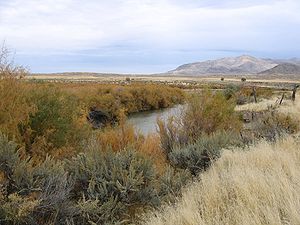
The Sevier River extending 383 miles (616.4 km), is the longest Utah river entirely in the state and drains an extended chain of mountain farming valleys to the intermittent Sevier Lake
. The Upper Sevier is used extensively for irrigation
, and consequently Sevier Lake
is now essentially dry.
Upper: The Sevier headwaters are in northwestern Kane County
along the western side of the Paunsaugunt Plateau
, and it flows northward into Garfield County
through an extended valley beside the plateau past Hatch
and Panguitch
. Along the Garfield-Piute
county line, the Sevier descends through the narrow 5 mi (8 km) Circleville Canyon, emerging into Circle Valley at Circleville
. It then flows northeast towards Junction
, where it receives the East Fork from the east and passes through the Piute Reservoir.
Central: It flows north across Piute County to Marysvale
then descends through 8 mi (13 km) Sevier Canyon
, emerging south of Sevier
. It then flows northeast past Richfield
and Salina
.
Gunnison and Lower: After the San Pitch confluence and ~20 mi (32.2 km) southwest of Nephi
, the river flows west around the north end of the Canyon Mountains into the Sevier Desert, then southwest past Delta
and into Sevier Lake in central Millard County
, along the western side of the Cricket Mountains. It is impounded in southwestern Juab County
at the north end of the valley to form the 20-mi (32 km) long Sevier Bridge Reservoir. DMAD reservoir and Gunnison Bend reservoirs are near Delta with Sevier's water. DMAD water goes to the Intermountain Power Project's coal-fired plant located 9 miles west of US-6, north of Delta.
The Dominguez-Escalante Expedition
crossed the river in 1776.
The Sevier River Water Users Association has installed solar-powered monitoring equipment, the Real-time Telemetry System, which reports on river flows, canal diversion flows, reservoir elevations and weather each hour. See http://www.SevierRiver.org.
Sevier Lake
Sevier Lake is an intermittent and endorheic lake which lies in the lowest part of the Sevier Desert, Millard County, Utah. Like Great Salt Lake and Utah Lake, it is a remnant of Pleistocene Lake Bonneville. Sevier Lake is fed primarily by the Beaver and Sevier rivers, and the additional inflow...
. The Upper Sevier is used extensively for irrigation
Irrigation
Irrigation may be defined as the science of artificial application of water to the land or soil. It is used to assist in the growing of agricultural crops, maintenance of landscapes, and revegetation of disturbed soils in dry areas and during periods of inadequate rainfall...
, and consequently Sevier Lake
Sevier Lake
Sevier Lake is an intermittent and endorheic lake which lies in the lowest part of the Sevier Desert, Millard County, Utah. Like Great Salt Lake and Utah Lake, it is a remnant of Pleistocene Lake Bonneville. Sevier Lake is fed primarily by the Beaver and Sevier rivers, and the additional inflow...
is now essentially dry.
Course
The Sevier River Water Users Association subdivides the river into four mainstream sections: Upper, Central, Gunnison and Lower.Upper: The Sevier headwaters are in northwestern Kane County
Kane County, Utah
As of the census of 2000, there were 6,046 people, 2,237 households, and 1,628 families residing in the county. The population density was 2 people per square mile . There were 3,767 housing units at an average density of 1 per square mile...
along the western side of the Paunsaugunt Plateau
Paunsaugunt Plateau
The Paunsaugunt Plateau is a dissected plateau, rising to an elevation of , in southwestern Utah in the United States. Located in northern Kane County and southwestern Garfield County, it is approximately wide, and extends southward from the Sevier Plateau approximately , terminating in the Pink...
, and it flows northward into Garfield County
Garfield County, Utah
Garfield County is a county located in the U.S. state of Utah. As of 2000 the population was 4,735. It was named for James A. Garfield, President of the United States in 1881. Its county seat and largest city is Panguitch.-Geography:...
through an extended valley beside the plateau past Hatch
Hatch, Utah
Hatch is a town in Garfield County, Utah, United States. The population was 127 at the 2000 census. It is approximately 217 miles from Salt Lake City.-Geography:...
and Panguitch
Panguitch, Utah
Panguitch is a city in and the county seat of Garfield County, Utah, United States. The population was 1,623 at the 2000 census.-Geography:Panguitch is located at ....
. Along the Garfield-Piute
Piute County, Utah
Piute County is a county located in the U.S. state of Utah. The population in 2000 was 1,435, and by 2005 had been estimated to decrease to 1,365. It was named for the Paiute tribe of Native Americans. The county seat is Junction and the largest city is Circleville.-Geography:According to the U.S...
county line, the Sevier descends through the narrow 5 mi (8 km) Circleville Canyon, emerging into Circle Valley at Circleville
Circleville, Utah
Circleville is a town in Piute County, Utah, United States. The population was 505 at the 2000 census.-Geography:Circleville is located at ....
. It then flows northeast towards Junction
Junction, Utah
Junction is a town in and the county seat of Piute County, Utah, United States. The population was 177 at the 2000 census.-Geography:Junction is located at ....
, where it receives the East Fork from the east and passes through the Piute Reservoir.
Central: It flows north across Piute County to Marysvale
Marysvale, Utah
Marysvale is a town in Piute County, Utah, United States. The population was 381 at the 2000 census. Marysvale is a trail head for the Paiute ATV Trail.-Geography:Marysvale is located at ....
then descends through 8 mi (13 km) Sevier Canyon
Sevier Canyon
Marysvale Canyon or Sevier Canyon runs eight miles north from Marysvale, Utah to the town of Sevier, Utah. It is a steep walled canyon formed by the flow of the meandering Sevier River....
, emerging south of Sevier
Sevier, Utah
Sevier is an unincorporated community in southwestern Sevier County, Utah, United States. It lies in the valley of the Sevier River along U.S. Route 89 southwest of the city of Richfield, the county seat of Sevier County. Its elevation is 5,584 feet . Although Sevier is unincorporated, it...
. It then flows northeast past Richfield
Richfield, Utah
Richfield is a city in and the county seat of Sevier County, Utah, in the United States, and is the largest city in southern-central Utah. As of the 2010 census, the city population was 7,551. It lies in the Mormon Corridor, just off of Interstate 70 about 40 miles east of its junction with...
and Salina
Salina, Utah
Salina is a city in Sevier County, Utah, United States. The population was 2,393 at the 2000 census.-History:The first permanent settlers moved into the area in 1864 at the direction of leaders of the Church of Jesus Christ of Latter-day Saints...
.
Gunnison and Lower: After the San Pitch confluence and ~20 mi (32.2 km) southwest of Nephi
Nephi, Utah
Nephi is a city in Juab County, Utah, United States. It is part of the Provo–Orem, Utah Metropolitan Statistical Area. The population was 4,733 at the 2000 census. It is the county seat of Juab County. It was settled by Mormon pioneers in 1851, and is the principal city in Juab Valley, an...
, the river flows west around the north end of the Canyon Mountains into the Sevier Desert, then southwest past Delta
Delta, Utah
Delta is a city in Millard County, Utah, United States. The population was 3,209 at the 2000 census.-Geography:Delta is located at ....
and into Sevier Lake in central Millard County
Millard County, Utah
Millard County is a county located in the U.S. state of Utah. In 2010, its population was 12,420. It was named for Millard Fillmore, thirteenth President of the United States. Its county seat is Fillmore and the largest city is Delta.-Geography:...
, along the western side of the Cricket Mountains. It is impounded in southwestern Juab County
Juab County, Utah
Juab County is a county located in the U.S. state of Utah. As of 2000 the population was 8,238, and by 2005 had been estimated at 9,113. It was named from an Indian word meaning thirsty valley, or possibly only valley. Its county seat and largest city is Nephi.Juab County is part of the...
at the north end of the valley to form the 20-mi (32 km) long Sevier Bridge Reservoir. DMAD reservoir and Gunnison Bend reservoirs are near Delta with Sevier's water. DMAD water goes to the Intermountain Power Project's coal-fired plant located 9 miles west of US-6, north of Delta.
The Dominguez-Escalante Expedition
Dominguez-Escalante Expedition
The Dominguez-Escalante Expedition was conducted in 1776 to find an overland route from Santa Fe, New Mexico to Spanish missions in California...
crossed the river in 1776.
The Sevier River Water Users Association has installed solar-powered monitoring equipment, the Real-time Telemetry System, which reports on river flows, canal diversion flows, reservoir elevations and weather each hour. See http://www.SevierRiver.org.