
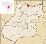
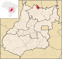
Montividiu do Norte
Encyclopedia
| Montividiu do Norte | |
|---|---|
| State | Goiás Goiás Goiás is a state of Brazil, located in the central part of the country. The name Goiás comes from the name of an indigenous community... |
| Area: | 1,333 km² |
| Population: | 4,395 (IBGE 2007) |
| Elevation: | 435 m above sea level |
| Postcode (CEP): | 76465-000 |
| Became a city: | 1993 |
| Distance to Goiânia Goiânia -Climate:The city has a tropical wet and dry climate with an average temperature of . There's a wet season, from October to April, and a dry one, from May to September. Annual rainfall is around 1,520 mm.... : |
444 km. |
| IBGE statistical microregion: | Porangatu Microregion Porangatu Microregion The Porangatu Microregion is a statistical region created by IBGE in north-central Goiás state, Brazil. The most important city is Porangatu... |
| Website: | none |
Town
A town is a human settlement larger than a village but smaller than a city. The size a settlement must be in order to be called a "town" varies considerably in different parts of the world, so that, for example, many American "small towns" seem to British people to be no more than villages, while...
and municipality
Municipality
A municipality is essentially an urban administrative division having corporate status and usually powers of self-government. It can also be used to mean the governing body of a municipality. A municipality is a general-purpose administrative subdivision, as opposed to a special-purpose district...
in Goiás
Goiás
Goiás is a state of Brazil, located in the central part of the country. The name Goiás comes from the name of an indigenous community...
state, Brazil
Brazil
Brazil , officially the Federative Republic of Brazil , is the largest country in South America. It is the world's fifth largest country, both by geographical area and by population with over 192 million people...
. It is a part of the Porangatu Microregion
Porangatu Microregion
The Porangatu Microregion is a statistical region created by IBGE in north-central Goiás state, Brazil. The most important city is Porangatu...
. It had a population in 2007 of 4,395. It became a municipality in 1993.
Location
Montividiu do Norte is located in the extreme north of the state, only 34 km. south of the border from the state of TocantinsTocantins
Tocantins may refer to:* Tocantins, a state in Brazil* Tocantins River, a river in Brazil* Survivor: Tocantins, a reality show set in Tocantins, Brazil* Tocantins Esporte Clube, a Brazilian football club...
. It is situated between two rivers: Rio Santa Teresa and Rio Canabrava, both of which are tributaries of the Tocantins River
Tocantins River
The Tocantins is a river in Brazil, the central fluvial artery of the country. In the Tupi language, its name means "toucan's beak" . It runs from south to north for about 2,640 km. It is not really a branch of the Amazon River, although usually so considered, since its waters flow into the...
.
- Distance to GoiâniaGoiânia-Climate:The city has a tropical wet and dry climate with an average temperature of . There's a wet season, from October to April, and a dry one, from May to September. Annual rainfall is around 1,520 mm....
: 444 km - Distance to PorangatuPorangatuParangatu is a town in Goiás state, Brazil-Geography:Parangatu is in its own microregion, Porangatu Microregion, of 226,766 inhabitants in an area of 35.287 km²; 426 km from the state capital, Goiânia. This microregion serves as a nucleus for eighteen municipalities in the north of Goiás state...
: 61 km
Highway connections to Goiânia
Goiânia
-Climate:The city has a tropical wet and dry climate with an average temperature of . There's a wet season, from October to April, and a dry one, from May to September. Annual rainfall is around 1,520 mm....
are made by GO-080 / Nerópolis
Nerópolis
Nerópolis is a small city and municipality in central Goiás state, Brazil.-Location:The municipality is part of the metropolitan region of Goiânia, which is 42 kilometers to the west. It is nationally known as the city of garlic and sweets...
/ São Francisco de Goiás
São Francisco de Goiás
São Francisco de Goiás is a small town and municipality in central Goiás state, Brazil.Municipal boundaries:*North: Jaraguá*South: Petrolina de Goiás*East: Pirenópolis*West: Jesúpolis and Jaraguá...
/ BR-153 / Jaraguá / GO-080 / Goianésia
Goianésia
Goianésia is a municipality in the state of Goiás, Brazil. It is a large producer of sugarcane for production of alcohol used as a source of fuel.-Location:...
/ Barro Alto
Barro Alto
Barro Alto is a small town and municipality in northern Goiás state, Brazil, famous for its nickel mine and production of rubber. The population was 6,446 in 2007 and the total area of the municipality was 1,231.8 km².-Location:...
/ BR-080 / GO-342 / BR-153 / Uruaçu
Uruaçu
Uruaçu is a small city and municipality in north Goiás state, Brazil.-Geography:Uruaçu is located north of Anápolis and Goiânia on the important interstate highway BR-153, which links Brasília to Belém. It is 269 km. from Goiânia and 244 km. from Brasília...
/ Santa Tereza de Goiás
Santa Tereza de Goiás
Santa Tereza de Goias is a small town and municipality in north Goiás state, Brazil. Santa Tereza de Goiás is often spelled ""Santa Teresa de Goiás"".-Location:Santa Tereza is located in the extreme north of the state 35 km. south of Porangatu...
/ GO-241 / Formoso
Formoso
Formoso is a small town and municipality in north Goiás state, Brazil. The population was 5,241 in a total area of 844 km².Highway connections from Goiânia are made by GO-080 / Nerópolis / São Francisco de Goiás / BR-153 / Jaraguá / GO-080 / Goianésia / Barro Alto / GO-342 / BR-080 / BR-153 /...
/ GO-142 / Trombas
Trombas
Trombas is a small town and municipality in north Goiás state, Brazil.-Location:Trombas is located in the extreme north of the state, between Formoso and Montividiu do Norte. It is east of the regional center, Porangatu....
.
Montividiu do Norte is surrounded by the following municipalities:
- north: TocantinsTocantinsTocantins may refer to:* Tocantins, a state in Brazil* Tocantins River, a river in Brazil* Survivor: Tocantins, a reality show set in Tocantins, Brazil* Tocantins Esporte Clube, a Brazilian football club...
- east: PorangatuPorangatuParangatu is a town in Goiás state, Brazil-Geography:Parangatu is in its own microregion, Porangatu Microregion, of 226,766 inhabitants in an area of 35.287 km²; 426 km from the state capital, Goiânia. This microregion serves as a nucleus for eighteen municipalities in the north of Goiás state...
- west: MinaçuMinaçuMinaçu is a small city and municipality in the north of the state of Goiás, Brazil. There is a large asbestos mine in the municipality.-Location and climate:...
- south: TrombasTrombasTrombas is a small town and municipality in north Goiás state, Brazil.-Location:Trombas is located in the extreme north of the state, between Formoso and Montividiu do Norte. It is east of the regional center, Porangatu....
Demographics
In 2007, the population density was 3.30 inhab/km². The population has been growing rapidly since the first count in 1996, when it was 2,610. The population is almost evenly distributed between urban and rural areas. The growth rate between 1996 and 2007 was 4.85%.Politics
In February 2007, the Mayor was Misael Antônio Teixeira. The city council had nine members, and there were 2,899 eligible voters in 2007.Economy
The economy is based on agriculture, cattle raising, services, public administration, and small transformation industries. In 2007, there was one industrial unit and 30 retail units. There were no financial institutions in the town in 2005. There were 127 automobiles, 14 trucks, 51 pickup trucks, and 187 motorcycles (2007). (IBGE)As of 2006, there were 74,600 head of cattle, of which 6,200 were milk cows. Poultry and swine production was modest. The main agricultural products were rice, bananas, sugarcane, corn, and soybeans. None exceeded 1,000 hectares in planted area.
Agricultural Census (2006)
- Farms: 699
- Planted area: 796 hectares
- Natural Pasture: 80,871 hectares
- Woodland: 24,811 hectares
- Persons occupied related to the farm owner: 1,513
- Persons occupied not related to farm owner: 66 (IBGE)
Health and education
As of 2007, there were no hospitals and one walk-in health clinic. The infant mortality rate was 48.95% — one of the highest in the state.As of 2006, the school system had nine schools with 1,364 students. There were no institutions of higher learning. The adult literacy rate was 80.9%.
Municipal Human Development IndexHuman Development IndexThe Human Development Index is a composite statistic used to rank countries by level of "human development" and separate "very high human development", "high human development", "medium human development", and "low human development" countries...
- MHDI: 0.659
- State ranking: 232 (out of 242 municipalities)
- National ranking: 3,629 (out of 5,507 municipalities)
Index of Economic Development (Seplan 2001)
- 225/246 municipalities. See Seplan
Index of Social Development (Seplan 2000)
- 241/246 municipalities. See Seplan