
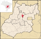
Goianésia
Encyclopedia
| Goianésia | |
|---|---|
| State | Goiás Goiás Goiás is a state of Brazil, located in the central part of the country. The name Goiás comes from the name of an indigenous community... |
| Area: | 1,547.65 km² |
| Population: | 53,806 (IBGE 2007) |
| Elevation: | 640 m above sea level |
| Postcode (CEP): | 76380-000 |
| Became a city: | 1953 |
| Distance to Goiânia Goiânia -Climate:The city has a tropical wet and dry climate with an average temperature of . There's a wet season, from October to April, and a dry one, from May to September. Annual rainfall is around 1,520 mm.... : |
182 km. |
| IBGE statistical microregion: | Ceres Microregion Ceres Microregion The Ceres Microregion is located in north-central Goiás state, Brazil. It includes 22 cities with a total population of 215,820 inhabitants . The total area is 13,224.40 km² and the population density is 16.32 inhab/km². The most important cities are Ceres and Goianésia.The most populous... |
| Website: | Portal da Prefeitura Municipal de Goianésia |
Goiás
Goiás is a state of Brazil, located in the central part of the country. The name Goiás comes from the name of an indigenous community...
, Brazil
Brazil
Brazil , officially the Federative Republic of Brazil , is the largest country in South America. It is the world's fifth largest country, both by geographical area and by population with over 192 million people...
. It is a large producer of sugarcane for production of alcohol used as a source of fuel.
Location
Goianésia is located almost due north of Anápolis (150 km), 54 km from the Belém-Brasília highway. GoiâniaGoiânia
-Climate:The city has a tropical wet and dry climate with an average temperature of . There's a wet season, from October to April, and a dry one, from May to September. Annual rainfall is around 1,520 mm....
, the state capital is 182 km away, while Brasília
Brasília
Brasília is the capital city of Brazil. The name is commonly spelled Brasilia in English. The city and its District are located in the Central-West region of the country, along a plateau known as Planalto Central. It has a population of about 2,557,000 as of the 2008 IBGE estimate, making it the...
, the national capital is 280 km. away. Highway connections from Goiânia
Goiânia
-Climate:The city has a tropical wet and dry climate with an average temperature of . There's a wet season, from October to April, and a dry one, from May to September. Annual rainfall is around 1,520 mm....
are made by GO-080 / Nerópolis
Nerópolis
Nerópolis is a small city and municipality in central Goiás state, Brazil.-Location:The municipality is part of the metropolitan region of Goiânia, which is 42 kilometers to the west. It is nationally known as the city of garlic and sweets...
/ São Francisco de Goiás
São Francisco de Goiás
São Francisco de Goiás is a small town and municipality in central Goiás state, Brazil.Municipal boundaries:*North: Jaraguá*South: Petrolina de Goiás*East: Pirenópolis*West: Jesúpolis and Jaraguá...
/ BR-153 / Jaraguá / GO-080. See Seplan for the complete list.
Municipal boundaries:
- Norte: São Luíz do NorteSão Luíz do NorteSão Luís do Norte is a small town and municipality in northeastern Goiás state, Brazil. An alternative spelling is "São Luís do Norte".-Location:São Luís is located 58 km. north of Ceres on the important BR-153 highway....
and Santa Rita do Novo DestinoSanta Rita do Novo DestinoSanta Rita do Novo Destino is a small town and municipality in northeastern Goiás state, Brazil.-Location:Santa Rita do Novo Destino is 82 km. east of Ceres and 15 km. north of Goianésia. Highway connections from Goiânia are made by taking GO-080 / Nerópolis / São Francisco de Goiás / BR-153 /... - South: Jaraguá and PirenópolisPirenópolisPirenópolis is a town located in the Brazilian state of Goiás. It is well known for its waterfalls and colonial architecture, and a popular festival involving mounted horses called Festa do Divino Espírito Santo which takes place 45 days after Easter....
- East: Santa IsabelSanta Isabel, Goiás-Location:Santa Isabel is a small town and municipality in north-central Goiás state, Brazil. It is 21 kilometers from Ceres, the nearest regional center. Santa Isabel has municipal boundaries with Rubiataba, Itapaci, Nova Glória, Rialma, and Carmo do Rio Verde...
- West: Barro AltoBarro AltoBarro Alto is a small town and municipality in northern Goiás state, Brazil, famous for its nickel mine and production of rubber. The population was 6,446 in 2007 and the total area of the municipality was 1,231.8 km².-Location:...
and Vila PropícioVila PropícioVila Propício is a small town and municipality in central Goiás state, Brazil. It is a large producer of sugarcane.-Location:Vila Propício is located in the Entorno de Brasília micro-region and has boundaries with the following municipalities:...
The municipality contains the sources of the Peixes, Bois, and Patos rivers. Average annual temperatures range from 22 to 25 degrees Celsius.
Demographic data
- Population growth rate 2000/2007: 1.30.%
- Urban population in 2007: 40,934
- Rural population in 2007: 3,872
Economy
Agro-industry plays a large role in the economy of the municipality, with importance given to the production of alcohol and sugar. Two destillaries are located in the town, both processing alcohol and sugar.Sugar cane
Sugarcane
Sugarcane refers to any of six to 37 species of tall perennial grasses of the genus Saccharum . Native to the warm temperate to tropical regions of South Asia, they have stout, jointed, fibrous stalks that are rich in sugar, and measure two to six metres tall...
is the most important crop of Goianésia, with a planted area of more than 12,000 hectares. Corn, dry farmed rice, and soybeans are also important crops. Tomato production has also increased as well as the planting of rubber trees.
Most of the small rural properties have milk as their main source of income, which is used to supply the dairies of the region. Cattle raising is still important with the municipality having 109,000 head in 2006, of which 25,500 were dairy cattle.
Other activities relevant to the economy are: meat packing, production of feed, mineral salt, gravel, and bricks.
- Industrial units: 92 (06/2007)
- Retail units: 638 (08/2007)
- Banking institutions: 4 (08/2007)
- Dairies: 2 (05/2006)
- Distilleries: 2 (07/2007)
- Meatpacking units: 1 (05/2006)
- Industrial Area: Distrito Agroindustrial - DAIAGO (2007)
- Automobiles: 5,459 in 2004 (IBGE/Sepin)
In 2006 there were 816 farms employing 1,500 workers. The total agricultural area was 106,550 ha., of which 12,000 ha. were planted in crops, 73,000 ha. were natural pasture, and 18,000 ha. were forest or woodland. There were 203 tractors on 131 of the farms.
Education and health
- Literacy rate: 86.3%
- Infant mortality rate: 25.58 in 1,000 live births
- Schools: 51 (2006)
- Students: 15,548
- Higher education: UEG - Faculdade de Educação, Ciências e Letras de Goianésia, Faculdade Betel de Goianésia - FABEGO.
- Hospitals: 05 (2007
- Hospital beds: 199 (IBGE/Sepin)
- Municipal Human Development IndexHuman Development IndexThe Human Development Index is a composite statistic used to rank countries by level of "human development" and separate "very high human development", "high human development", "medium human development", and "low human development" countries...
0.743 - State ranking: 95 (out of 242 municipalities in 2000)
- National ranking: 2,064 (out of 5,507 municipalities in 2000)
For the complete list see frigoletto.com.br
Communications
Goianésia has one interstate and intermunicipal bus company which maintains links with Goiânia, Brasília, and other cities in Goiás. There is a small municipal airport with a paved runway of 1,300 meters.External links
- Goianésia City Council - The Official Website (in Portuguese)
- Photo gallery of the city
- IBGE - Cidades@ Goianésia
- Goianésia in English