

Porangatu
Encyclopedia
Parangatu is a town in Goiás
state, Brazil
, of 226,766 inhabitants in an area of 35.287 km²; 426 km from the state capital, Goiânia
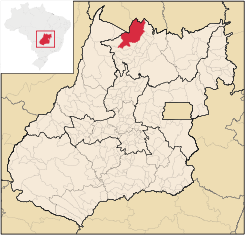
. This microregion serves as a nucleus for eighteen municipalities in the north of Goiás state. The municipal seat is just west of the important interstate highway BR-153, which connects Belém
with Brasília
and just south of the state line with the recently created state of Tocantins
.
Important rivers are the Santa Tereza, Cana Brava, Ouro Pintado, Santa Maria and Gregório. The climate is hot, moist tropical, with frequent occurrences of a maximum of 40 °C. The average minimum is 21C, the maximum is 40 °C and the minimum is 21 °C. The elevation is 390 meters above sea level and the highest points are Serra da Sabina and Serra dos Picos.
, when it became part of the municipality of Santana, later changed to Uruaçu
. In 1943 Descoberto was changed to Porangatu, from Tupi-Guarani, meaning "poran", beautiful, and "gatu", landscape. In 1948 it was dismembered from Uruaçu. With the building of the Belem
to Brasília
highway (BR-153) in 1958 Porangatu grew quickly to become the most important commercial center of this new region that was opening up to migrants from the south.
Most of the economy is dependent on cattle raising and agriculture, but in recent years the region has attracted medium size industries. Porangatu is today the commercial center for the north of Goiás receiving people from all the neighboring region to buy its products. Commerce employed 2,065 people in 2005.
(August 2007)
Municipal Human Development Index
Goiás
Goiás is a state of Brazil, located in the central part of the country. The name Goiás comes from the name of an indigenous community...
state, Brazil
Brazil
Brazil , officially the Federative Republic of Brazil , is the largest country in South America. It is the world's fifth largest country, both by geographical area and by population with over 192 million people...
| Porangatu | |
|---|---|
| State | Goiás Goiás Goiás is a state of Brazil, located in the central part of the country. The name Goiás comes from the name of an indigenous community... |
| Area: | 4,820.4 km² |
| Population: | 39,238 (IBGE 2007) |
| Elevation: | 390 m above sea level |
| Postcode (CEP): | 76550-000 |
| Became a city: | 1948 |
| Distance to Goiânia Goiânia -Climate:The city has a tropical wet and dry climate with an average temperature of . There's a wet season, from October to April, and a dry one, from May to September. Annual rainfall is around 1,520 mm.... : |
426 km. |
| Statistical microregion: | Porangatu Porangatu Microregion The Porangatu Microregion is a statistical region created by IBGE in north-central Goiás state, Brazil. The most important city is Porangatu... |
| Website: | Porangatu.go |
Geography
Parangatu is in its own microregion, Porangatu MicroregionPorangatu Microregion
The Porangatu Microregion is a statistical region created by IBGE in north-central Goiás state, Brazil. The most important city is Porangatu...
, of 226,766 inhabitants in an area of 35.287 km²; 426 km from the state capital, Goiânia
Goiânia
-Climate:The city has a tropical wet and dry climate with an average temperature of . There's a wet season, from October to April, and a dry one, from May to September. Annual rainfall is around 1,520 mm....
. This microregion serves as a nucleus for eighteen municipalities in the north of Goiás state. The municipal seat is just west of the important interstate highway BR-153, which connects Belém
Belém
Belém is a Brazilian city, the capital and largest city of state of Pará, in the country's north region. It is the entrance gate to the Amazon with a busy port, airport and bus/coach station...
with Brasília
Brasília
Brasília is the capital city of Brazil. The name is commonly spelled Brasilia in English. The city and its District are located in the Central-West region of the country, along a plateau known as Planalto Central. It has a population of about 2,557,000 as of the 2008 IBGE estimate, making it the...
and just south of the state line with the recently created state of Tocantins
Tocantins (state)
Tocantins is one of the states of Brazil. . The state was formed in 1988 out of the northern part of Goiás, and construction began on the capital, Palmas, in 1989, in contrast to most of the other cities in the state which date back to the Portuguese colonial period...
.
Important rivers are the Santa Tereza, Cana Brava, Ouro Pintado, Santa Maria and Gregório. The climate is hot, moist tropical, with frequent occurrences of a maximum of 40 °C. The average minimum is 21C, the maximum is 40 °C and the minimum is 21 °C. The elevation is 390 meters above sea level and the highest points are Serra da Sabina and Serra dos Picos.
History
The first settlement began in the eighteenth century with the discovery of gold in the region. Attacks from the local Indians, the Canoeiros, kept the settlement, called Descoberto, from developing. Until 1933 it was a district belonging to Pilar de GoiásPilar de Goiás
Pilar de Goiás is a small town and municipality in north-central Goiás state, Brazil.-Location:Pilar is located 252 kilometers north of the state capital, Goiânia in the Ceres Microregion. It is connected to the south of the state, with its main urban centers, by highway BR-153...
, when it became part of the municipality of Santana, later changed to Uruaçu
Uruaçu
Uruaçu is a small city and municipality in north Goiás state, Brazil.-Geography:Uruaçu is located north of Anápolis and Goiânia on the important interstate highway BR-153, which links Brasília to Belém. It is 269 km. from Goiânia and 244 km. from Brasília...
. In 1943 Descoberto was changed to Porangatu, from Tupi-Guarani, meaning "poran", beautiful, and "gatu", landscape. In 1948 it was dismembered from Uruaçu. With the building of the Belem
Belem
Belem or Belém may refer to:* Belém, capital city of the Brazilian state of Pará* Belem , a three-masted barque from France* Belém, Alagoas, a municipality located in the Brazilian state of Alagoas...
to Brasília
Brasília
Brasília is the capital city of Brazil. The name is commonly spelled Brasilia in English. The city and its District are located in the Central-West region of the country, along a plateau known as Planalto Central. It has a population of about 2,557,000 as of the 2008 IBGE estimate, making it the...
highway (BR-153) in 1958 Porangatu grew quickly to become the most important commercial center of this new region that was opening up to migrants from the south.
Political information
- Mayor: José Osvaldo da Silva (January 2005)
- Eligible voters: 28,739 (December 2007)
- City council: 9 members
Demographic information
- Population density: 8.14 inhab/km² (2007)
- Urban population: 33,077(2007)
- Rural population: 6,161 (2007)
- Population growth or loss: a gain of about 5,500 people since 1980 -0,45% decrease 1996/2007
Economic information
The economy is based on agriculture, cattle raising, services, public administration, and small transformation industries.Most of the economy is dependent on cattle raising and agriculture, but in recent years the region has attracted medium size industries. Porangatu is today the commercial center for the north of Goiás receiving people from all the neighboring region to buy its products. Commerce employed 2,065 people in 2005.
- Industrial units: 75 (2007)
- Commercial units: 432 (2007)
- Bank agencies: Banco do Brasil S.A. - BRADESCO S.A. - Banco Itaú S.A. - CEF.
(August 2007)
- Dairy: - LACEL - Laticínios Ceres Ltda. - Agroindústria Camapum Ltda (22/05/2006)
- Meat packing plant: FRIRAL - Frigorífico Fronteiras Ltda.; - HBC Comércio e Representações Ltda. (22/05/2006)
- Motor vehicles: 4,810 automobiles (2007)
Agricultural Data (2006)
- Farms: 1,532
- Total agricultural Area: 395,310 hectares
- Permanent Planted Area: 331 hectares
- Temporary Planted Area: 5,823 hectares
- Natural Pasture: 267,860 hectares
- Woodland and Forest: 113,655 hectares
- Workers related to the farm owner: 2,717
- Workers not related to the farm owner: 1,022 (IBGE)
- Cattle herd: 332,000 head (2006)
- Main crops: rice (1,500 hectares) corn (1,400 hectares), and soybeans (2,000 hectares).
Education (2006)
- Schools: 48 with 12,244 students
- Middle school enrollment: 2,277 students
- Higher education: Porangatu has a campus of the Universidade Estadual de Goiás with courses in the following areas: Biology, Mathematics, Geography, Humanities and Computer Science.UEG
- Adult literacy rate: 80.5% (2000) (national average was 86.4%)
Health (2007)
- Hospitals: 6
- Hospital beds: 200
- Ambulatory clinics: 18
- Infant mortality rate: 32.75 (2000) (national average was 33.0).
Municipal Human Development IndexHuman Development IndexThe Human Development Index is a composite statistic used to rank countries by level of "human development" and separate "very high human development", "high human development", "medium human development", and "low human development" countries...
2000
- MHDI: 0.761
- State ranking: 52 (out of 242 municipalities)
- National ranking: 1,562 (out of 5,507 municipalities)