
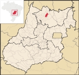
Formoso
Encyclopedia
| Formoso | |
|---|---|
| State | Goiás Goiás Goiás is a state of Brazil, located in the central part of the country. The name Goiás comes from the name of an indigenous community... |
| Area: | 844 km² |
| Population: | 5,241(IBGE 2007) |
| Urban population: | 3,681 |
| Population density: | 6.21 inhab/km² (2007) |
| Population growth rate: | -1.12% 1996/2007 |
| Elevation: | 569 m above sea level |
| Postcode (CEP): | 76470-000 |
| Became a city: | 1963 |
| Mayor: | Maurílio Macedo Gomes |
| Distance to Goiânia Goiânia -Climate:The city has a tropical wet and dry climate with an average temperature of . There's a wet season, from October to April, and a dry one, from May to September. Annual rainfall is around 1,520 mm.... : |
399 km. |
| IBGE statistical microregion: | Porangatu Microregion Porangatu Microregion The Porangatu Microregion is a statistical region created by IBGE in north-central Goiás state, Brazil. The most important city is Porangatu... |
| Website: | none |
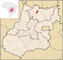
Formoso is a small town and municipality
Municipality
A municipality is essentially an urban administrative division having corporate status and usually powers of self-government. It can also be used to mean the governing body of a municipality. A municipality is a general-purpose administrative subdivision, as opposed to a special-purpose district...
in north Goiás
Goiás
Goiás is a state of Brazil, located in the central part of the country. The name Goiás comes from the name of an indigenous community...
state, Brazil
Brazil
Brazil , officially the Federative Republic of Brazil , is the largest country in South America. It is the world's fifth largest country, both by geographical area and by population with over 192 million people...
. The population was 5,241 (2007) in a total area of 844 km².
Highway connections from Goiânia
Goiânia
-Climate:The city has a tropical wet and dry climate with an average temperature of . There's a wet season, from October to April, and a dry one, from May to September. Annual rainfall is around 1,520 mm....
are made by GO-080 / Nerópolis
Nerópolis
Nerópolis is a small city and municipality in central Goiás state, Brazil.-Location:The municipality is part of the metropolitan region of Goiânia, which is 42 kilometers to the west. It is nationally known as the city of garlic and sweets...
/ São Francisco de Goiás
São Francisco de Goiás
São Francisco de Goiás is a small town and municipality in central Goiás state, Brazil.Municipal boundaries:*North: Jaraguá*South: Petrolina de Goiás*East: Pirenópolis*West: Jesúpolis and Jaraguá...
/ BR-153 / Jaraguá / GO-080 / Goianésia
Goianésia
Goianésia is a municipality in the state of Goiás, Brazil. It is a large producer of sugarcane for production of alcohol used as a source of fuel.-Location:...
/ Barro Alto
Barro Alto
Barro Alto is a small town and municipality in northern Goiás state, Brazil, famous for its nickel mine and production of rubber. The population was 6,446 in 2007 and the total area of the municipality was 1,231.8 km².-Location:...
/ GO-342 / BR-080 / BR-153 / Uruaçu
Uruaçu
Uruaçu is a small city and municipality in north Goiás state, Brazil.-Geography:Uruaçu is located north of Anápolis and Goiânia on the important interstate highway BR-153, which links Brasília to Belém. It is 269 km. from Goiânia and 244 km. from Brasília...
/ Santa Tereza de Goiás
Santa Tereza de Goiás
Santa Tereza de Goias is a small town and municipality in north Goiás state, Brazil. Santa Tereza de Goiás is often spelled ""Santa Teresa de Goiás"".-Location:Santa Tereza is located in the extreme north of the state 35 km. south of Porangatu...
/ GO-241.
Formoso is surrounded by the following municipalities:
- north: Santa Tereza de GoiásSanta Tereza de GoiásSanta Tereza de Goias is a small town and municipality in north Goiás state, Brazil. Santa Tereza de Goiás is often spelled ""Santa Teresa de Goiás"".-Location:Santa Tereza is located in the extreme north of the state 35 km. south of Porangatu...
and TrombasTrombasTrombas is a small town and municipality in north Goiás state, Brazil.-Location:Trombas is located in the extreme north of the state, between Formoso and Montividiu do Norte. It is east of the regional center, Porangatu.... - east: CampinorteCampinorteCampinorte is a small city and municipality in north-central Goiás state, Brazil. The population was 9,697 in a total area of 1,068 km².-Location:...
and MinaçuMinaçuMinaçu is a small city and municipality in the north of the state of Goiás, Brazil. There is a large asbestos mine in the municipality.-Location and climate:... - west: Estrela do NorteEstrela do NorteEstrela do Norte refers to:*A municipality in the state of São Paulo, Brazil. See Estrela do Norte, São Paulo.*A municipality in the state of Goiás, Brazil. See Estrela do Norte, Goiás.*A football club from Cachoeiro de Itapemirim, Brazil....
- south: CampinorteCampinorteCampinorte is a small city and municipality in north-central Goiás state, Brazil. The population was 9,697 in a total area of 1,068 km².-Location:...
and Mara RosaMara RosaMara Rosa is a small town and municipality in north-central Goiás state, Brazil.-Location:Mara Rosa is located 356 kilometers north of Goiânia in the Porangatu Microregion. It is 11 kilometers east of the Belém-Brasília highway, between the basins of the Araguaia River and the Tocantins River...
The economy is based on livestock raising, modest agriculture, small commerce, and government services. There was one bank in 2007.
The main agricultural activities were cattle raising: 50,000 head (2006) and the growing of rice, sugarcane, manioc, corn, and banana (all fewer than 1,000 hectares). In 2006 there were 605 farms with 2,114 hectares of planted area. Pasture land made up 45,700 hectares. Approximately 2,000 people were employed in agriculture. Statistics are from IBGE
The literacy rate was 84.0% (2000) and the infant mortality rate was 24.07 in 1,000 live births. There were 7 schools and 1 hospital with 18 beds. The score on the Municipal Human Development Index
Human Development Index
The Human Development Index is a composite statistic used to rank countries by level of "human development" and separate "very high human development", "high human development", "medium human development", and "low human development" countries...
was 0.737.
- State ranking: 119 (out of 242 municipalities in 2000)
- National ranking: 2,250 (out of 5,507 municipalities in 2000)