
Barro Alto
Encyclopedia
| Barro Alto | |
|---|---|
| State | Goiás Goiás Goiás is a state of Brazil, located in the central part of the country. The name Goiás comes from the name of an indigenous community... |
| Area: | 1,231.8 km² |
| Population: | 6,446 (IBGE 2007) |
| Urban population: | 4,329 |
| Population density: | 5.90 inhab/km² |
| Population growth rate: | -4.29.% 1996/2007 |
| Elevation: | 605m above sea level |
| Postcode (CEP): | 76390-000 |
| Became a city: | 1958 |
| Mayor: | Antônio Luciano Batista de Lucena |
| Distance to Goiânia Goiânia -Climate:The city has a tropical wet and dry climate with an average temperature of . There's a wet season, from October to April, and a dry one, from May to September. Annual rainfall is around 1,520 mm.... : |
228 km. |
| IBGE Statistical Microregion: | Ceres Microregion Ceres Microregion The Ceres Microregion is located in north-central Goiás state, Brazil. It includes 22 cities with a total population of 215,820 inhabitants . The total area is 13,224.40 km² and the population density is 16.32 inhab/km². The most important cities are Ceres and Goianésia.The most populous... |
| Website: | none |
Town
A town is a human settlement larger than a village but smaller than a city. The size a settlement must be in order to be called a "town" varies considerably in different parts of the world, so that, for example, many American "small towns" seem to British people to be no more than villages, while...
and municipality
Municipality
A municipality is essentially an urban administrative division having corporate status and usually powers of self-government. It can also be used to mean the governing body of a municipality. A municipality is a general-purpose administrative subdivision, as opposed to a special-purpose district...
in northern Goiás
Goiás
Goiás is a state of Brazil, located in the central part of the country. The name Goiás comes from the name of an indigenous community...
state, Brazil
Brazil
Brazil , officially the Federative Republic of Brazil , is the largest country in South America. It is the world's fifth largest country, both by geographical area and by population with over 192 million people...
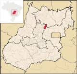
, famous for its nickel mine and production of rubber. The population was 6,446 in 2007 and the total area of the municipality was 1,231.8 km².
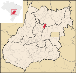
Location
Barro Alto is in the Ceres MicroregionCeres Microregion
The Ceres Microregion is located in north-central Goiás state, Brazil. It includes 22 cities with a total population of 215,820 inhabitants . The total area is 13,224.40 km² and the population density is 16.32 inhab/km². The most important cities are Ceres and Goianésia.The most populous...
and is in an underpopulated region south of the Serra de Mesa artificial lake. It is 54 kilometers southeast of the important BR-153 highway, which links Anápolis
Anápolis
Anápolis is the third largest city in the State of Goiás in Brazil. It lies in the center of a rich agricultural region and has become a leader in food processing and pharmaceutical plants.-Location and population:...
to Belém
Belém
Belém is a Brazilian city, the capital and largest city of state of Pará, in the country's north region. It is the entrance gate to the Amazon with a busy port, airport and bus/coach station...
.
The distance to Goiânia
Goiânia
-Climate:The city has a tropical wet and dry climate with an average temperature of . There's a wet season, from October to April, and a dry one, from May to September. Annual rainfall is around 1,520 mm....
is 228 km. Highway connections are made by GO-080 / Nerópolis
Nerópolis
Nerópolis is a small city and municipality in central Goiás state, Brazil.-Location:The municipality is part of the metropolitan region of Goiânia, which is 42 kilometers to the west. It is nationally known as the city of garlic and sweets...
/ São Francisco de Goiás
São Francisco de Goiás
São Francisco de Goiás is a small town and municipality in central Goiás state, Brazil.Municipal boundaries:*North: Jaraguá*South: Petrolina de Goiás*East: Pirenópolis*West: Jesúpolis and Jaraguá...
/ BR-153 / Jaraguá / GO-080 / Goianésia
Goianésia
Goianésia is a municipality in the state of Goiás, Brazil. It is a large producer of sugarcane for production of alcohol used as a source of fuel.-Location:...
and 41 km northeast. See Sepin for complete list.
Neighboring municipalities are:
- north: NiquelândiaNiquelândiaNiquelândia is a small city and municipality in northern Goiás state, Brazil. It is the largest municipality in the state in area and is an important producer of minerals.-Geography:...
- south: GoianésiaGoianésiaGoianésia is a municipality in the state of Goiás, Brazil. It is a large producer of sugarcane for production of alcohol used as a source of fuel.-Location:...
- east: Padre BernardoPadre BernardoPadre Bernardo is a small city and municipality north of the Federal District of Brazil in Goiás state, Brazil.-Location:Padre Bernardo is located 42 km. north of the boundary with the Federal District...
- west: Santa Rita do Novo DestinoSanta Rita do Novo DestinoSanta Rita do Novo Destino is a small town and municipality in northeastern Goiás state, Brazil.-Location:Santa Rita do Novo Destino is 82 km. east of Ceres and 15 km. north of Goianésia. Highway connections from Goiânia are made by taking GO-080 / Nerópolis / São Francisco de Goiás / BR-153 /...
History
The foundation of Barro Alto began in 1949 on the Fazenda Barro Alto owned by the Silva brothers, who had lived there since 1940. In 1951 a highway connection with GoianésiaGoianésia
Goianésia is a municipality in the state of Goiás, Brazil. It is a large producer of sugarcane for production of alcohol used as a source of fuel.-Location:...
was opened up, and in 1956 a chapel dedicated to Nossa Senora d'Abadia was built. In 1958 it became a district of Pirenópolis
Pirenópolis
Pirenópolis is a town located in the Brazilian state of Goiás. It is well known for its waterfalls and colonial architecture, and a popular festival involving mounted horses called Festa do Divino Espírito Santo which takes place 45 days after Easter....
, separating in the same year to become a municipality.
The economy
Barro Alto has an important open pit nickel mine operated by Anglo-American. Other economic activities are cattle raising, agriculture, services, and small transformation industries. Public administration is a big employer with 389 workers. Barro Alto is the largest producer of rubber (coagulated latex) in the state of GoiásGoiás
Goiás is a state of Brazil, located in the central part of the country. The name Goiás comes from the name of an indigenous community...
. It produced 2,130 tons in 2006. (Sepin There were 53,500 head of cattle (8,200 dairy cows) in 2006. (Sepin) Barro Alto has a large agricultural production. In 2006 there were 296 farms with 1,247 hectares of permanent crops and 3,570 hectares of perennial crops. Pasture land made up 39,000 hectares. The main agricultural products in 2006 were rubber (710 hectares), rice (650 hectares), sugarcane (3,600 hectares), corn (2,300 hectares), and soybeans (1,500 hectares). (Sepin)
Health and education
The town was served by one hospital with 39 beds in 2007. The infant mortality rate in 2000 was 25.06. In the educational sector there were 11 schools with 2,264 students. The literacy rate in 2000 was 79.2%.The United Nations Human Development Index
Human Development Index
The Human Development Index is a composite statistic used to rank countries by level of "human development" and separate "very high human development", "high human development", "medium human development", and "low human development" countries...
(2000) ranked Barro Alto 200 out of 242 municipalities in the state of Goiás
Goiás
Goiás is a state of Brazil, located in the central part of the country. The name Goiás comes from the name of an indigenous community...
with a combined life expectancy of 68.5 years, 0.76% adult literacy, and a per capita monthly income of 143.9 reais, which at March 2006 exchange rates was worth 55.2 euros. The HDI for Barro Alto was 0.78.
Sources of Data
See List of municipalities in Goiás