
Molasse basin
Encyclopedia
The Molasse basin is a foreland basin
north of the Alps
, that formed during the Oligocene
and Miocene
epoch
s. The basin formed due to the flexure of the European plate under the weight of the orogenic wedge
of the Alps that was forming to the south.
In geology
, the name "molasse basin" is sometimes also used in a general sense for a synorogenic (formed contemporaneously with the orogen) forelandbasin of the type north of the Alps. The basin is the type locality
of molasse
, a sedimentary sequence of conglomerates
and sandstone
s, material that was removed from the developing mountain chain by erosion
and denudation
, that is typical for foreland basins.
, Switzerland
, Germany
and Austria
. The western end is at Lake Geneva
, where the basins outcrop
is just 20 km wide. Further to the northeast the basin becomes wider. It forms the subsurface of the Swiss Mittelland
and reaches its largest width (circa 130 km) in the Bavaria
n foreland
of the Alps. From Amstetten
to Sankt Pölten
the basin forms a narrow band, just 10 km in width. After that is widens again to the east. North of the Danube River it connects with the Vienna basin
, and is thus connected with the Pannonian Basin
further east.
The region where the molasse crops out it divided into two. The Subalpine Molasse zone along the Alps and the Foreland Molasse zone further into the foreland. In the Foreland Molasse zone the molasse sediments are relatively undisturbed, in the Subalpine Molasse zone the beds are often tilted, folded
and thrust
over each other.
era
, the region was covered by a shallow sea that was the northern margin of the Alpine part of the Tethys Ocean
(Valais Ocean
in the west, Tethys Ocean proper in the east). The Molasse basin was formed when the orogenic wedge of the forming Alps was pushed north over the European continental margin
, due to the convergent
movement of the European and Apulian plate
s during the Paleogene
period. The weight of the orogenic wedge made the European plate bend downward, resulting in the formation of a deep marine foredeep. In the Eocene
epoch (55 to 34 million years ago) the basin became deeper until it formed a small oceanic trench
north of the developing orogen, in which flysch
sediments were deposited.
Due to the huge amounts of sediments that were eroded from the forming mountain chain the basin was filled up and got shallower. During the Oligocene and Miocene epochs (more exactly between 10 and 30 million years ago), undeep marine to continental molasse was deposited in the basin. Around 10 to 5 million years ago, tectonic uplift had raised the basin to such a height that netto sedimentation stopped. From the south, the molasse deposits were overthrust about 10 kilometers by the Helvetic nappes
, which caused the deformation in the Subalpine Molasse zone. The Jura mountains
, a fold and thrust belt along the present Swiss-French border, also originated from this tectonic phase. In some places in the Jura mountains, molasse deposits were folded together with older Mesozoic limestone
s. In present day central Switzerland however, the molasse formed a thick, competent mass that was thrusted northward in one piece over a decollement
horizon at the base of the Mesozoic, in Triassic
evaporite
s. Deformation instead localized further north, thus forming the relatively flat Swiss Mittelland between the Alps and Jura Mountains. The Swiss part of the Molasse basin is now located in between the Alps and the Jura mountains, as a large piggy-back basin. In the Eastern Alps
an external mountain range such as the Jura Mountains never developed. Due to the last phase of tectonic uplift around 5 million years ago, the molasse in the Swiss Plateau
, the South Bavarian plain and Eastern Austria is now at 350 to 400 meters above sea level
at its northern rim, slowly rises southwards and can attain more than 1,000 m at its contact with the Alps.
, this molasse is treated as a group
that is divided into four formations. This division is made on weather the sedimentary facies is continental or marine.
The lowermost formation is the Lower Marine Molasse (in German
: Untere Meeresmolasse). Its age is Rupelian
(Early Oligocene, 34 to 28 million years old) and it consists of shallow marine sand, clay and marl. On top of this is the Lower Freshwater Molasse (German: Untere Süsswassermolasse) of Chattian
and Aquitanian
age (28 to 22 million years). Due to an eustatic drop of the sea level combined by tectonic uplift, the basin was now above sea level. This second formation therefore consists of fluviatile sands and clays and huge alluvial fan
systems (conglomerates and breccias) originating from the Alps to the south.
By 22 million years ago, the Alpine foreland was flooded again due to tectonic subsidence. A shallow (intertidal
) marine environment formed from Lyon
to Vienna
. In this environment the third formation, the Upper Marine Molasse, was formed. It consists of marine sands, clays and marls and new fan conglomerates and is of Burdigalian
to Langhian
age (22 to 16 million years old). More tectonic uplift caused the sea to retreat one final time and between 16 and 5 million years ago (during the Serravallian
, Tortonian
and Messinian
/Pontian
ages), the basin was in a continental facies again. The fluviatile sands and clays and fan conglomerates of this time form the Upper Freshwater Molasse, the topmost molasse formation.
Around 5 million years ago a phase of uplift occurred in the Alps. During this phase the Molasse basin ceased to be an area of net sedimentation.
Foreland basin
A foreland basin is a depression that develops adjacent and parallel to a mountain belt. Foreland basins form because the immense mass created by crustal thickening associated with the evolution of a mountain belt causes the lithosphere to bend, by a process known as lithospheric flexure...
north of the Alps
Alps
The Alps is one of the great mountain range systems of Europe, stretching from Austria and Slovenia in the east through Italy, Switzerland, Liechtenstein and Germany to France in the west....
, that formed during the Oligocene
Oligocene
The Oligocene is a geologic epoch of the Paleogene Period and extends from about 34 million to 23 million years before the present . As with other older geologic periods, the rock beds that define the period are well identified but the exact dates of the start and end of the period are slightly...
and Miocene
Miocene
The Miocene is a geological epoch of the Neogene Period and extends from about . The Miocene was named by Sir Charles Lyell. Its name comes from the Greek words and and means "less recent" because it has 18% fewer modern sea invertebrates than the Pliocene. The Miocene follows the Oligocene...
epoch
Epoch (geology)
An epoch is a subdivision of the geologic timescale based on rock layering. In order, the higher subdivisions are periods, eras and eons. We are currently living in the Holocene epoch...
s. The basin formed due to the flexure of the European plate under the weight of the orogenic wedge
Accretionary wedge
An accretionary wedge or accretionary prism is formed from sediments that are accreted onto the non-subducting tectonic plate at a convergent plate boundary...
of the Alps that was forming to the south.
In geology
Geology
Geology is the science comprising the study of solid Earth, the rocks of which it is composed, and the processes by which it evolves. Geology gives insight into the history of the Earth, as it provides the primary evidence for plate tectonics, the evolutionary history of life, and past climates...
, the name "molasse basin" is sometimes also used in a general sense for a synorogenic (formed contemporaneously with the orogen) forelandbasin of the type north of the Alps. The basin is the type locality
Type locality (geology)
Type locality , also called type area or type locale, is the where a particular rock type, stratigraphic unit, fossil or mineral species is first identified....
of molasse
Molasse
The term "molasse" refers to the sandstones, shales and conglomerates formed as terrestrial or shallow marine deposits in front of rising mountain chains. The molasse is deposited in a foreland basin, especially on top of flysch, for example that left from the rising Alps, or erosion in the Himalaya...
, a sedimentary sequence of conglomerates
Conglomerate (geology)
A conglomerate is a rock consisting of individual clasts within a finer-grained matrix that have become cemented together. Conglomerates are sedimentary rocks consisting of rounded fragments and are thus differentiated from breccias, which consist of angular clasts...
and sandstone
Sandstone
Sandstone is a sedimentary rock composed mainly of sand-sized minerals or rock grains.Most sandstone is composed of quartz and/or feldspar because these are the most common minerals in the Earth's crust. Like sand, sandstone may be any colour, but the most common colours are tan, brown, yellow,...
s, material that was removed from the developing mountain chain by erosion
Erosion
Erosion is when materials are removed from the surface and changed into something else. It only works by hydraulic actions and transport of solids in the natural environment, and leads to the deposition of these materials elsewhere...
and denudation
Denudation
In geology, denudation is the long-term sum of processes that cause the wearing away of the earth’s surface leading to a reduction in elevation and relief of landforms and landscapes...
, that is typical for foreland basins.
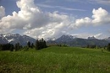
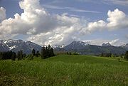
Geographic location
The Molasse basin stretches over a length of 1000 kilometers along the long axis of the Alps, in FranceFrance
The French Republic , The French Republic , The French Republic , (commonly known as France , is a unitary semi-presidential republic in Western Europe with several overseas territories and islands located on other continents and in the Indian, Pacific, and Atlantic oceans. Metropolitan France...
, Switzerland
Switzerland
Switzerland name of one of the Swiss cantons. ; ; ; or ), in its full name the Swiss Confederation , is a federal republic consisting of 26 cantons, with Bern as the seat of the federal authorities. The country is situated in Western Europe,Or Central Europe depending on the definition....
, Germany
Germany
Germany , officially the Federal Republic of Germany , is a federal parliamentary republic in Europe. The country consists of 16 states while the capital and largest city is Berlin. Germany covers an area of 357,021 km2 and has a largely temperate seasonal climate...
and Austria
Austria
Austria , officially the Republic of Austria , is a landlocked country of roughly 8.4 million people in Central Europe. It is bordered by the Czech Republic and Germany to the north, Slovakia and Hungary to the east, Slovenia and Italy to the south, and Switzerland and Liechtenstein to the...
. The western end is at Lake Geneva
Lake Geneva
Lake Geneva or Lake Léman is a lake in Switzerland and France. It is one of the largest lakes in Western Europe. 59.53 % of it comes under the jurisdiction of Switzerland , and 40.47 % under France...
, where the basins outcrop
Outcrop
An outcrop is a visible exposure of bedrock or ancient superficial deposits on the surface of the Earth. -Features:Outcrops do not cover the majority of the Earth's land surface because in most places the bedrock or superficial deposits are covered by a mantle of soil and vegetation and cannot be...
is just 20 km wide. Further to the northeast the basin becomes wider. It forms the subsurface of the Swiss Mittelland
Mittelland
Mittelland may refer to*The Swiss plateau *The former name of the municipality Barleben, in Ohrekreis, Saxony-Anhalt, Germany*The immense crater created by British explosives on the German island of Heligoland...
and reaches its largest width (circa 130 km) in the Bavaria
Bavaria
Bavaria, formally the Free State of Bavaria is a state of Germany, located in the southeast of Germany. With an area of , it is the largest state by area, forming almost 20% of the total land area of Germany...
n foreland
Foreland
Foreland is the easternmost point of the Isle of Wight. It is located three miles east of the town of Brading, and due south of the city of Portsmouth on the British mainland. It is characterised by a pub called the Crab and Lobster and various beach huts plus a beach cafe and a coast guard...
of the Alps. From Amstetten
Amstetten
Amstetten can refer to several geographical terms:*Amstetten , a municipality in the Alb-Donau district of Germany*Amstetten, Lower Austria, a municipality in southwest Lower Austria...
to Sankt Pölten
Sankt Pölten
Sankt Pölten is the capital city of the State of Lower Austria in northeast Austria. With inhabitants , it is Lower Austria's largest city...
the basin forms a narrow band, just 10 km in width. After that is widens again to the east. North of the Danube River it connects with the Vienna basin
Vienna Basin
The Vienna Basin is a sedimentary basin between the Alps and the Carpathian Mountains...
, and is thus connected with the Pannonian Basin
Pannonian Basin
The Pannonian Basin or Carpathian Basin is a large basin in East-Central Europe.The geomorphological term Pannonian Plain is more widely used for roughly the same region though with a somewhat different sense - meaning only the lowlands, the plain that remained when the Pliocene Pannonian Sea dried...
further east.
The region where the molasse crops out it divided into two. The Subalpine Molasse zone along the Alps and the Foreland Molasse zone further into the foreland. In the Foreland Molasse zone the molasse sediments are relatively undisturbed, in the Subalpine Molasse zone the beds are often tilted, folded
Fold (geology)
The term fold is used in geology when one or a stack of originally flat and planar surfaces, such as sedimentary strata, are bent or curved as a result of permanent deformation. Synsedimentary folds are those due to slumping of sedimentary material before it is lithified. Folds in rocks vary in...
and thrust
Thrust fault
A thrust fault is a type of fault, or break in the Earth's crust across which there has been relative movement, in which rocks of lower stratigraphic position are pushed up and over higher strata. They are often recognized because they place older rocks above younger...
over each other.
Tectonic history
Before the development of the Molasse basin, in the MesozoicMesozoic
The Mesozoic era is an interval of geological time from about 250 million years ago to about 65 million years ago. It is often referred to as the age of reptiles because reptiles, namely dinosaurs, were the dominant terrestrial and marine vertebrates of the time...
era
Era
An era is a commonly used word for long period of time. When used in science, for example geology, eras denote clearly defined periods of time of arbitrary but well defined length, such as for example the Mesozoic era from 252 Ma–66 Ma, delimited by a start event and an end event. When used in...
, the region was covered by a shallow sea that was the northern margin of the Alpine part of the Tethys Ocean
Tethys Ocean
The Tethys Ocean was an ocean that existed between the continents of Gondwana and Laurasia during the Mesozoic era before the opening of the Indian Ocean.-Modern theory:...
(Valais Ocean
Valais Ocean
The Valais Ocean is a disappeared piece of oceanic crust which was situated between the continent Europe and the microcontinent Iberia or so called Briançonnais microcontinent...
in the west, Tethys Ocean proper in the east). The Molasse basin was formed when the orogenic wedge of the forming Alps was pushed north over the European continental margin
Continental margin
The continental margin is the zone of the ocean floor that separates the thin oceanic crust from thick continental crust. Continental margins constitute about 28% of the oceanic area....
, due to the convergent
Convergent boundary
In plate tectonics, a convergent boundary, also known as a destructive plate boundary , is an actively deforming region where two tectonic plates or fragments of lithosphere move toward one another and collide...
movement of the European and Apulian plate
Apulian Plate
The Adriatic or Apulian Plate is a small tectonic plate carrying primarily continental crust that broke away from the African plate along a large transform fault in the Cretaceous period. The name Adriatic Plate is usually used when referring to the northern part of the plate...
s during the Paleogene
Paleogene
The Paleogene is a geologic period and system that began 65.5 ± 0.3 and ended 23.03 ± 0.05 million years ago and comprises the first part of the Cenozoic Era...
period. The weight of the orogenic wedge made the European plate bend downward, resulting in the formation of a deep marine foredeep. In the Eocene
Eocene
The Eocene Epoch, lasting from about 56 to 34 million years ago , is a major division of the geologic timescale and the second epoch of the Paleogene Period in the Cenozoic Era. The Eocene spans the time from the end of the Palaeocene Epoch to the beginning of the Oligocene Epoch. The start of the...
epoch (55 to 34 million years ago) the basin became deeper until it formed a small oceanic trench
Trench
A trench is a type of excavation or depression in the ground. Trenches are generally defined by being deeper than they are wide , and by being narrow compared to their length ....
north of the developing orogen, in which flysch
Flysch
Flysch is a sequence of sedimentary rocks that is deposited in a deep marine facies in the foreland basin of a developing orogen. Flysch is typically deposited during an early stage of the orogenesis. When the orogen evolves the foreland basin becomes shallower and molasse is deposited on top of...
sediments were deposited.
Due to the huge amounts of sediments that were eroded from the forming mountain chain the basin was filled up and got shallower. During the Oligocene and Miocene epochs (more exactly between 10 and 30 million years ago), undeep marine to continental molasse was deposited in the basin. Around 10 to 5 million years ago, tectonic uplift had raised the basin to such a height that netto sedimentation stopped. From the south, the molasse deposits were overthrust about 10 kilometers by the Helvetic nappes
Helvetic nappes
The Helvetic zone, Helvetic system or the Helveticum is a geologic subdivision of the Alps. The Helvetic zone crops out mainly in Switzerland, hence the name . Rocks in the Helvetic zone are sedimentary and were originally deposited at the southern margin of the European plate...
, which caused the deformation in the Subalpine Molasse zone. The Jura mountains
Jura mountains
The Jura Mountains are a small mountain range located north of the Alps, separating the Rhine and Rhone rivers and forming part of the watershed of each...
, a fold and thrust belt along the present Swiss-French border, also originated from this tectonic phase. In some places in the Jura mountains, molasse deposits were folded together with older Mesozoic limestone
Limestone
Limestone is a sedimentary rock composed largely of the minerals calcite and aragonite, which are different crystal forms of calcium carbonate . Many limestones are composed from skeletal fragments of marine organisms such as coral or foraminifera....
s. In present day central Switzerland however, the molasse formed a thick, competent mass that was thrusted northward in one piece over a decollement
Decollement
Décollement is a gliding plane between two rock masses. In French, "décoller" means "to detach from" or "to rip off" and was first used by geologists studying the structure of the Swiss Jura Mountains, but is also known as a detachment zone. This is a structure of strata owing to deformation,...
horizon at the base of the Mesozoic, in Triassic
Triassic
The Triassic is a geologic period and system that extends from about 250 to 200 Mya . As the first period of the Mesozoic Era, the Triassic follows the Permian and is followed by the Jurassic. Both the start and end of the Triassic are marked by major extinction events...
evaporite
Evaporite
Evaporite is a name for a water-soluble mineral sediment that result from concentration and crystallization by evaporation from an aqueous solution. There are two types of evaporate deposits, marine which can also be described as ocean deposits, and non-marine which are found in standing bodies of...
s. Deformation instead localized further north, thus forming the relatively flat Swiss Mittelland between the Alps and Jura Mountains. The Swiss part of the Molasse basin is now located in between the Alps and the Jura mountains, as a large piggy-back basin. In the Eastern Alps
Eastern Alps
Eastern Alps is the name given to the eastern half of the Alps, usually defined as the area east of the Splügen Pass in eastern Switzerland. North of the Splügen Pass, the Posterior Rhine forms the border, and south of the pass, the Liro river and Lake Como form the boundary line.-Geography:The...
an external mountain range such as the Jura Mountains never developed. Due to the last phase of tectonic uplift around 5 million years ago, the molasse in the Swiss Plateau
Swiss plateau
The Swiss Plateau or Central Plateau constitutes one of the three major landscapes in Switzerland alongside the Jura mountains and the Swiss Alps. It covers about 30% of the Swiss surface...
, the South Bavarian plain and Eastern Austria is now at 350 to 400 meters above sea level
Sea level
Mean sea level is a measure of the average height of the ocean's surface ; used as a standard in reckoning land elevation...
at its northern rim, slowly rises southwards and can attain more than 1,000 m at its contact with the Alps.
Stratigraphy
The total thickness of molasse deposits in the basin can be up to 6 kilometers. LithostratigraphicallyLithostratigraphy
Lithostratigraphy is a sub-discipline of stratigraphy, the geological science associated with the study of strata or rock layers. Major focuses include geochronology, comparative geology, and petrology...
, this molasse is treated as a group
Group (stratigraphy)
A group in stratigraphy is a lithostratigraphic unit, a part of the geologic record or rock column that consists of defined rock strata. Groups are divided into formations and are sometimes themselves grouped into "supergroups"....
that is divided into four formations. This division is made on weather the sedimentary facies is continental or marine.
The lowermost formation is the Lower Marine Molasse (in German
German language
German is a West Germanic language, related to and classified alongside English and Dutch. With an estimated 90 – 98 million native speakers, German is one of the world's major languages and is the most widely-spoken first language in the European Union....
: Untere Meeresmolasse). Its age is Rupelian
Rupelian
The Rupelian is, in the geologic timescale, the older of two ages or the lower of two stages of the Oligocene epoch/series. It spans the time between and . It is preceded by the Priabonian stage and is followed by the Chattian stage....
(Early Oligocene, 34 to 28 million years old) and it consists of shallow marine sand, clay and marl. On top of this is the Lower Freshwater Molasse (German: Untere Süsswassermolasse) of Chattian
Chattian
The Chattian is, in the geologic timescale, the youngest of two ages or upper of two stages of the Oligocene epoch/series. It spans the time between and . The Chattian is preceded by the Rupelian and is followed by the Aquitanian .-Stratigraphic definition:The Chattian was introduced by Austrian...
and Aquitanian
Aquitanian
Aquitanian could refer to:*Aquitanian age, a geological age, the first stage of the Miocene Epoch*Aquitanian language, an ancient language spoken in the region later known as Gascony* Anything originating from Aquitaine, a region of France....
age (28 to 22 million years). Due to an eustatic drop of the sea level combined by tectonic uplift, the basin was now above sea level. This second formation therefore consists of fluviatile sands and clays and huge alluvial fan
Alluvial fan
An alluvial fan is a fan-shaped deposit formed where a fast flowing stream flattens, slows, and spreads typically at the exit of a canyon onto a flatter plain. A convergence of neighboring alluvial fans into a single apron of deposits against a slope is called a bajada, or compound alluvial...
systems (conglomerates and breccias) originating from the Alps to the south.
By 22 million years ago, the Alpine foreland was flooded again due to tectonic subsidence. A shallow (intertidal
Intertidal zone
The intertidal zone is the area that is above water at low tide and under water at high tide . This area can include many different types of habitats, with many types of animals like starfish, sea urchins, and some species of coral...
) marine environment formed from Lyon
Lyon
Lyon , is a city in east-central France in the Rhône-Alpes region, situated between Paris and Marseille. Lyon is located at from Paris, from Marseille, from Geneva, from Turin, and from Barcelona. The residents of the city are called Lyonnais....
to Vienna
Vienna
Vienna is the capital and largest city of the Republic of Austria and one of the nine states of Austria. Vienna is Austria's primary city, with a population of about 1.723 million , and is by far the largest city in Austria, as well as its cultural, economic, and political centre...
. In this environment the third formation, the Upper Marine Molasse, was formed. It consists of marine sands, clays and marls and new fan conglomerates and is of Burdigalian
Burdigalian
The Burdigalian is, in the geologic timescale, an age or stage in the early Miocene. It spans the time between 20.43 ± 0.05 Ma and 15.97 ± 0.05 Ma...
to Langhian
Langhian
The Langhian is, in the ICS geologic timescale, an age or stage in the middle Miocene epoch/series. It spans the time between 15.97 ± 0.05 Ma and 13.65 ± 0.05 Ma . The Langhian was a continuing warming period defined by Lorenzo Pareto in 1864, it was originally established in the Langhe area north...
age (22 to 16 million years old). More tectonic uplift caused the sea to retreat one final time and between 16 and 5 million years ago (during the Serravallian
Serravallian
The Serravallian is in the geologic timescale an age or a stage in the middle Miocene epoch/series, that spans the time between 13.65 ± 0.05 Ma and 11.608 ± 0.005 Ma...
, Tortonian
Tortonian
The Tortonian is in the geologic timescale an age or stage of the late Miocene that spans the time between 11.608 ± 0.005 Ma and 7.246 ± 0.005 Ma . It follows the Serravallian and is followed by the Messinian....
and Messinian
Messinian
The Messinian is in the geologic timescale the last age or uppermost stage of the Miocene. It spans the time between 7.246 ± 0.005 Ma and 5.332 ± 0.005 Ma...
/Pontian
Pontian
Pontian may refer to:* Pontian, in stratigraphy the uppermost Miocene Paratethys stage, coeval with the Messinian* Pontian Greeks, a group of ethnic Greek who inhabited northern Turkey* Pontian Islands, a group of islands on the coast of Italy...
ages), the basin was in a continental facies again. The fluviatile sands and clays and fan conglomerates of this time form the Upper Freshwater Molasse, the topmost molasse formation.
Around 5 million years ago a phase of uplift occurred in the Alps. During this phase the Molasse basin ceased to be an area of net sedimentation.