

Mexican Plateau
Encyclopedia
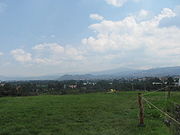
The Central Mexican Plateau, also known as the Mexican Altiplano or Altiplanicie Mexicana, is a large arid-to-semiarid plateau
that occupies much of northern and central Mexico
. Averaging 1825 m (5,987.5 ft) above sea level, it extends from the United States border in the north to the Cordillera Neovolcánica in the south, and is bounded by the Sierra Madre Occidental
and Sierra Madre Oriental
to the west and east, respectively. A low east-west mountain range in the state of Zacatecas divides the plateau into northern and southern sections. These two sections, called the Mesa del Norte and Mesa Central, are now generally regarded by geographers as sections of one plateau. The Mexican Plateau is mostly covered by deserts and xeric shrublands
, with pine-oak forests
covering the surrounding mountain ranges and forming sky island
s on some of the interior ranges. The Mexican Altiplano is one of six distinct physiographic sections of the Basin and Range Province, which in turn is part of the Intermontane Plateaus
physiographic division.
 The Mesa del Norte or northern plateau averages 1100 metres (3,608.9 ft) in elevation above mean sea level
and extends south from the Rio Grande
(Río Bravo del Norte) through the states of Chihuahua, Coahuila
, Durango
, Zacatecas
and San Luis Potosí
. Various narrow, isolated ridges cross the Mesa del Norte and numerous depressions also dot the region, the largest of which is the Bolsón de Mapimí
. The Río Bravo del Norte and its tributary, the Río Conchos
, drain portions of the northern plateau, and the Río Pánuco
and its tributaries drain the southeastern corner. Both rivers drain to the Gulf of Mexico
. Much of the northern plateau comprises internal drainage basins that do not drain to the sea. The Chihuahuan Desert
extends across the northern portion of the northern plateau, while the Meseta Central matorral covers the central portion, and the Central Mexican matorral
extends from the southern portion of the northern plateau across the southern plateau.
The Mesa Central or southern plateau is higher than its northern counterpart, averaging 2000 m (6,561.7 ft) in elevation. The southern plateau contains numerous valleys originally formed by ancient lakes. It extends across the states of Aguascalientes
, Jalisco
, Zacatecas
, Guanajuato
, Querétaro
, México
, and Hidalgo. Several of Mexico's most prominent cities, including Mexico City
and Guadalajara
, are located in the valleys of the southern plateau. Much of the southern plateau is drained by the Río Grande de Santiago
and its tributaries, including the Río Lerma, which drain east into the Pacific Ocean
. Tributaries of the Río Pánuco drain the eastern portion of the southern plateau. The Central Mexican matorral covers much of the southern plateau, with the subtropical Bajío dry forests
occupying the lower portions of the Lerma–Río Grande de Santiago basin.
Plateau
In geology and earth science, a plateau , also called a high plain or tableland, is an area of highland, usually consisting of relatively flat terrain. A highly eroded plateau is called a dissected plateau...
that occupies much of northern and central Mexico
Mexico
The United Mexican States , commonly known as Mexico , is a federal constitutional republic in North America. It is bordered on the north by the United States; on the south and west by the Pacific Ocean; on the southeast by Guatemala, Belize, and the Caribbean Sea; and on the east by the Gulf of...
. Averaging 1825 m (5,987.5 ft) above sea level, it extends from the United States border in the north to the Cordillera Neovolcánica in the south, and is bounded by the Sierra Madre Occidental
Sierra Madre Occidental
The Sierra Madre Occidental is a mountain range in western Mexico.-Setting:The range runs north to south, from just south of the Sonora–Arizona border southeast through eastern Sonora, western Chihuahua, Sinaloa, Durango, Zacatecas, Nayarit, Jalisco, Aguascalientes to Guanajuato, where it joins...
and Sierra Madre Oriental
Sierra Madre Oriental
The Sierra Madre Oriental is a mountain range in northeastern Mexico.-Setting:Spanning the Sierra Madre Oriental runs from Coahuila south through Nuevo León, southwest Tamaulipas, San Luis Potosí, Querétaro, and Hidalgo to northern Puebla, where it joins with the east-west running Eje Volcánico...
to the west and east, respectively. A low east-west mountain range in the state of Zacatecas divides the plateau into northern and southern sections. These two sections, called the Mesa del Norte and Mesa Central, are now generally regarded by geographers as sections of one plateau. The Mexican Plateau is mostly covered by deserts and xeric shrublands
Deserts and xeric shrublands
Deserts and xeric shrublands is a biome characterized by, relating to, or requiring only a small amount of moisture.-Definition and occurrence:...
, with pine-oak forests
Madrean pine-oak woodlands
The Madrean pine-oak woodlands are subtropical woodlands found in the mountains of Mexico and the southwestern United States.The Madrean pine-oak woodlands are found at higher elevations in Mexico's major mountain ranges, the Sierra Madre Occidental, the Sierra Madre Oriental, the Trans-Mexican...
covering the surrounding mountain ranges and forming sky island
Sky island
Sky islands are mountains that are isolated by surrounding lowlands of a dramatically different environment, a situation which, in combination with the altitudinal zonation of ecosystems, has significant implications for natural habitats. Endemism, vertical migration, and relict populations are...
s on some of the interior ranges. The Mexican Altiplano is one of six distinct physiographic sections of the Basin and Range Province, which in turn is part of the Intermontane Plateaus
Intermontane Plateaus
Physiographic regions of the U.S. InteriorSee:legendIn some places,high plateaus lie between the mountain ranges, for example,the plateau of Anatolia in Turkey and the plateau of Tibet.These are called "Intermontane plateaus"....
physiographic division.
Geography
Above mean sea level
The term above mean sea level refers to the elevation or altitude of any object, relative to the average sea level datum. AMSL is used extensively in radio by engineers to determine the coverage area a station will be able to reach...
and extends south from the Rio Grande
Rio Grande
The Rio Grande is a river that flows from southwestern Colorado in the United States to the Gulf of Mexico. Along the way it forms part of the Mexico – United States border. Its length varies as its course changes...
(Río Bravo del Norte) through the states of Chihuahua, Coahuila
Coahuila
Coahuila, formally Coahuila de Zaragoza , officially Estado Libre y Soberano de Coahuila de Zaragoza is one of the 31 states which, with the Federal District, comprise the 32 Federal Entities of Mexico...
, Durango
Durango
Durango officially Estado Libre y Soberano de Durango is one of the 31 states which, with the Federal District, comprise the 32 Federal Entities of Mexico. The state is located in Northwest Mexico. With a population of 1,632,934, it has Mexico's second-lowest population density, after Baja...
, Zacatecas
Zacatecas
Zacatecas officially Estado Libre y Soberano de Zacatecas is one of the 31 states which, with the Federal District, comprise the 32 Federal Entities of Mexico. It is divided in 58 municipalities and its capital city is Zacatecas....
and San Luis Potosí
San Luis Potosí
San Luis Potosí officially Estado Libre y Soberano de San Luis Potosí is one of the 31 states which, with the Federal District, comprise the 32 Federal Entities of Mexico. It is divided in 58 municipalities and its capital city is San Luis Potosí....
. Various narrow, isolated ridges cross the Mesa del Norte and numerous depressions also dot the region, the largest of which is the Bolsón de Mapimí
Bolsón de Mapimí
The Bolsón de Mapimí is an endorheic river basin located in the center-north of the Mexican Plateau.It is also known as the Comarca Lagunera, and is shared by the states of Durango, Coahuila, Chihuahua, and Zacatecas...
. The Río Bravo del Norte and its tributary, the Río Conchos
Rio Conchos
The Rio Conchos is a large river in the Mexican state of Chihuahua. It joins the Río Bravo del Norte at the town of Ojinaga, Chihuahua.-Description:...
, drain portions of the northern plateau, and the Río Pánuco
Pánuco River
The Pánuco River is a river in Mexico that flows from the River Moctezuma in the Valley of Mexico to the Gulf of Mexico.At its source, it serves as a channel for water-drainage for Mexico City. From there, it becomes the state border between Hidalgo and Querétaro as it moves towards San Luis...
and its tributaries drain the southeastern corner. Both rivers drain to the Gulf of Mexico
Gulf of Mexico
The Gulf of Mexico is a partially landlocked ocean basin largely surrounded by the North American continent and the island of Cuba. It is bounded on the northeast, north and northwest by the Gulf Coast of the United States, on the southwest and south by Mexico, and on the southeast by Cuba. In...
. Much of the northern plateau comprises internal drainage basins that do not drain to the sea. The Chihuahuan Desert
Chihuahuan Desert
The Chihuahuan Desert is a desert, and an ecoregion designation, that straddles the U.S.-Mexico border in the central and northern portions of the Mexican Plateau, bordered on the west by the extensive Sierra Madre Occidental range, and overlaying northern portions of the east range, the Sierra...
extends across the northern portion of the northern plateau, while the Meseta Central matorral covers the central portion, and the Central Mexican matorral
Central Mexican matorral
The Central Mexican matorral is an ecoregion of the Deserts and xeric shrublands Biome of central Mexico.-Setting:The Central Mexican matorral covers an area of on the southern portion of the Mexican Plateau....
extends from the southern portion of the northern plateau across the southern plateau.
The Mesa Central or southern plateau is higher than its northern counterpart, averaging 2000 m (6,561.7 ft) in elevation. The southern plateau contains numerous valleys originally formed by ancient lakes. It extends across the states of Aguascalientes
Aguascalientes
Aguascalientes is one of the 31 states which, with the Federal District, comprise the 32 Federal Entities of Mexico. It is divided in 11 municipalities and its capital city is Aguascalientes....
, Jalisco
Jalisco
Jalisco officially Estado Libre y Soberano de Jalisco is one of the 31 states which, with the Federal District, comprise the 32 Federal Entities of Mexico. It is located in Western Mexico and divided in 125 municipalities and its capital city is Guadalajara.It is one of the more important states...
, Zacatecas
Zacatecas
Zacatecas officially Estado Libre y Soberano de Zacatecas is one of the 31 states which, with the Federal District, comprise the 32 Federal Entities of Mexico. It is divided in 58 municipalities and its capital city is Zacatecas....
, Guanajuato
Guanajuato
Guanajuato officially Estado Libre y Soberano de Guanajuato is one of the 31 states which, with the Federal District, comprise the 32 Federal Entities of Mexico. It is divided in 46 municipalities and its capital city is Guanajuato....
, Querétaro
Querétaro
Querétaro officially Estado Libre y Soberano de Querétaro de Arteaga is one of the 31 states which, with the Federal District, comprise the 32 Federal Entities of Mexico. It is divided into 18 municipalities and its capital city is Santiago de Querétaro....
, México
Mexico (state)
México , officially: Estado Libre y Soberano de México is one of the 31 states which, with the Federal District, comprise the 32 Federal Entities of the United Mexican States. It is divided in 125 municipalities and its capital city is Toluca de Lerdo....
, and Hidalgo. Several of Mexico's most prominent cities, including Mexico City
Mexico City
Mexico City is the Federal District , capital of Mexico and seat of the federal powers of the Mexican Union. It is a federal entity within Mexico which is not part of any one of the 31 Mexican states but belongs to the federation as a whole...
and Guadalajara
Guadalajara, Jalisco
Guadalajara is the capital of the Mexican state of Jalisco, and the seat of the municipality of Guadalajara. The city is located in the central region of Jalisco in the western-pacific area of Mexico. With a population of 1,564,514 it is Mexico's second most populous municipality...
, are located in the valleys of the southern plateau. Much of the southern plateau is drained by the Río Grande de Santiago
Río Grande de Santiago
The Río Grande de Santiago is one of the longest rivers in Mexico, measuring up long. The river begins at Lake Chapala and continues roughly north-west through the Sierra Madre Occidental, receiving the Verde, Juchipila, Bolaños, and other tributaries...
and its tributaries, including the Río Lerma, which drain east into the Pacific Ocean
Pacific Ocean
The Pacific Ocean is the largest of the Earth's oceanic divisions. It extends from the Arctic in the north to the Southern Ocean in the south, bounded by Asia and Australia in the west, and the Americas in the east.At 165.2 million square kilometres in area, this largest division of the World...
. Tributaries of the Río Pánuco drain the eastern portion of the southern plateau. The Central Mexican matorral covers much of the southern plateau, with the subtropical Bajío dry forests
Bajío dry forests
The Bajío dry forests is a tropical dry broadleaf forest ecoregion of west-central Mexico.The Bajío dry forests lie in the southwestern portion of the Mexican Plateau...
occupying the lower portions of the Lerma–Río Grande de Santiago basin.
External links
- Mexican Plateau, Mexico City Region. Image Science and Analysis Laboratory, NASA-Johnson Space Center. 18 Mar. 2005. Earth from Space - Image Information.