
Intermontane Plateaus
Encyclopedia
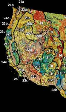 |
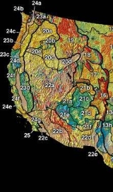
| Physiographic regions of the U.S. Interior See:legend |
In some places,high plateaus lie between the mountain ranges, for example,the plateau of Anatolia in Turkey and the plateau of Tibet.These are called "Intermontane plateaus".
The Intermontane Plateaus is one of eight U.S. Physiographic regions-divisions of the physical geography
Physical geography
Physical geography is one of the two major subfields of geography. Physical geography is that branch of natural science which deals with the study of processes and patterns in the natural environment like the atmosphere, biosphere and geosphere, as opposed to the cultural or built environment, the...
of the contiguous United States
Contiguous United States
The contiguous United States are the 48 U.S. states on the continent of North America that are south of Canada and north of Mexico, plus the District of Columbia....
. It is subdivided into physiographic province
Physiographic province
A physiographic province is a geographic region with a specific geomorphology and often specific subsurface rock type or structural elements.A continent may be subdivided into various physiographic provinces, each having a specific character, relief, and environment which contributes to its...
s, which are each subdivided into physiographic sections. It is located in the Western United States
Western United States
.The Western United States, commonly referred to as the American West or simply "the West," traditionally refers to the region comprising the westernmost states of the United States. Because the U.S. expanded westward after its founding, the meaning of the West has evolved over time...
, and composed of intermontane
Intermontane
Intermontane is a physiographic adjective formed from the prefix "inter-" and the adjective "montane" Usage includes intermontane basin such as New Zealand's Mackenzie Basin and intermontane...
plateau
Plateau
In geology and earth science, a plateau , also called a high plain or tableland, is an area of highland, usually consisting of relatively flat terrain. A highly eroded plateau is called a dissected plateau...
s and mountain range
Mountain range
A mountain range is a single, large mass consisting of a succession of mountains or narrowly spaced mountain ridges, with or without peaks, closely related in position, direction, formation, and age; a component part of a mountain system or of a mountain chain...
s .
Plateau Province
The Plateau province, just to the west of the southern Rocky MountainsRocky Mountains
The Rocky Mountains are a major mountain range in western North America. The Rocky Mountains stretch more than from the northernmost part of British Columbia, in western Canada, to New Mexico, in the southwestern United States...
, is characterized for the most part by large-textured forms. These have developed on a great thickness of nearly horizontal Palaeozoic, Mesozoic
Mesozoic
The Mesozoic era is an interval of geological time from about 250 million years ago to about 65 million years ago. It is often referred to as the age of reptiles because reptiles, namely dinosaurs, were the dominant terrestrial and marine vertebrates of the time...
and Tertiary
Tertiary
The Tertiary is a deprecated term for a geologic period 65 million to 2.6 million years ago. The Tertiary covered the time span between the superseded Secondary period and the Quaternary...
formations, and by a dry climate.
The province was uplifted and divided into great blocks by faults or monoclinal flexures and thus exposed to long-lasting denudation in a mid-Tertiary cycle of erosion. They were then broadly elevated again with renewed movement on some of the fault lines. The current erosion cycle was introduced in late Tertiary time during which the deep canyons of the region have been trenched. The results of the first cycle of erosion are seen in the widespread exposure of the resistant Carboniferous limestone as a broad platform in the south-western area of greater uplift through central Arizona
Arizona
Arizona ; is a state located in the southwestern region of the United States. It is also part of the western United States and the mountain west. The capital and largest city is Phoenix...
where the higher formations were worn away. They are also seen in the development of a series of huge, south-facing, retreating escarpments of irregular outline on the edges of the higher formations farther north. Each escarpment stands forth where a resistant formation overlies a weaker one. Each escarpment is separated from the next higher one by a broad step of weaker strata. A wonderful series of these forms occurs in southern Utah
Utah
Utah is a state in the Western United States. It was the 45th state to join the Union, on January 4, 1896. Approximately 80% of Utah's 2,763,885 people live along the Wasatch Front, centering on Salt Lake City. This leaves vast expanses of the state nearly uninhabited, making the population the...
, where in passing northward from the Carboniferous platform one ascends in succession the Chocolate Cliffs (Triassic
Triassic
The Triassic is a geologic period and system that extends from about 250 to 200 Mya . As the first period of the Mesozoic Era, the Triassic follows the Permian and is followed by the Jurassic. Both the start and end of the Triassic are marked by major extinction events...
sandstones), Vermilion and White Cliffs (Jurassic
Jurassic
The Jurassic is a geologic period and system that extends from about Mya to Mya, that is, from the end of the Triassic to the beginning of the Cretaceous. The Jurassic constitutes the middle period of the Mesozoic era, also known as the age of reptiles. The start of the period is marked by...
sandstones), the Gray Cliffs (Cretaceous
Cretaceous
The Cretaceous , derived from the Latin "creta" , usually abbreviated K for its German translation Kreide , is a geologic period and system from circa to million years ago. In the geologic timescale, the Cretaceous follows the Jurassic period and is followed by the Paleogene period of the...
sandstones, of remarkably cross-bedded structure, interpreted the dunes of an ancient desert), and finally the Pink Cliffs
Pink Cliffs
The Pink Cliffs are a series of highly-dissected cliffs, approximately 35 mi long, along the southeast edge of the Paunsaugunt Plateau in southwestern Utah in the United States...
(Eocene
Eocene
The Eocene Epoch, lasting from about 56 to 34 million years ago , is a major division of the geologic timescale and the second epoch of the Paleogene Period in the Cenozoic Era. The Eocene spans the time from the end of the Palaeocene Epoch to the beginning of the Oligocene Epoch. The start of the...
strata of fluviatile and lacustrine
Lacustrine
Lacustrine means "of a lake" or "relating to a lake".Specifically, it may refer to:*Lacustrine plain*Lacustrine delta-Fish:*Lacustrine goby , a type of small fish found in Philippine waters belonging to the Gobiidae family, known in Tagalog as dulong-See also:*Fluvial - of or relating a...
origin) of the high, forested plateaus. Associated with these irregular escarpments are occasional rectilinear ridges, the work of extensive erosion on monoclinal structures. A good example of this is Echo Cliffs lying east of the Painted Desert
Painted Desert, Arizona
The Painted Desert is a area of badlands located in Northern Arizona in the United States. The Arizona desert stretches from the Grand Canyon National Park into the Petrified Forest National Park and runs roughly astride and just north of the Little Colorado and the Puerco Rivers...
.
With the renewal of uplift by which the earlier cycle of erosion was interrupted and the present cycle introduced, inequalities of surface due to renewed faulting were again introduced. These still appear as cliffs, of more nearly rectilinear front than the retreating escarpments formed in the previous cycle. These cliffs are peculiar in gradually passing from one formation to another, and in having a height dependent on the displacement of the fault rather than on the structures in the fault face. They are already somewhat battered and dissected by erosion. The most important line of cliffs of this class is associated with the western and southern boundary of the plateau province where it was uplifted from the lower ground. The few rivers of the region must have reached the quiescence of old age in the earlier cycle, but were revived by uplift to a vigorous youth in the current cycle. It is to this newly introduced cycle of physiographic evolution that the deep canyons of the Plateau province are due. Thus the Virgin River
Virgin River
The Virgin River is a tributary of the Colorado River in the U.S. states of Utah, Nevada, and Arizona. The river is about long. It was designated Utah's first wild and scenic river in 2009, during the centennial celebration of Zion National Park.-Course:...
, a northern branch of the Colorado, has cut a vertical slit, 1000 ft. deep, hardly wider at the top than at the bottom, in the heavy Triassic sandstones of southern Utah. However the most famous example is the Grand Canyon
Grand Canyon
The Grand Canyon is a steep-sided canyon carved by the Colorado River in the United States in the state of Arizona. It is largely contained within the Grand Canyon National Park, the 15th national park in the United States...
of Arizona
Arizona
Arizona ; is a state located in the southwestern region of the United States. It is also part of the western United States and the mountain west. The capital and largest city is Phoenix...
, eroded by the Colorado river across the uplifted platform of Carboniferous limestone.
During the current cycle of erosion, several of the faults, whose scarps had been worn away in the previous cycle, have been brought to light again as topographic
Topography
Topography is the study of Earth's surface shape and features or those ofplanets, moons, and asteroids...
features by the removal of the weak strata along one side of the fault line, leaving the harder strata on the other side in relief. Such scarps are known as fault-line scarps, in distinction from the original fault scarps. They are peculiar in having their altitude dependent on the depth of revived erosion, instead of the amount of faulting, and they are sometimes topographically reversed, in that the revived scarp overlooks a lowland worn on a weak formation in the upheaved fault-block. Another consequence of revived erosion is seen in the occurrence of great landslides, where the removal of weak (Permian
Permian
The PermianThe term "Permian" was introduced into geology in 1841 by Sir Sir R. I. Murchison, president of the Geological Society of London, who identified typical strata in extensive Russian explorations undertaken with Edouard de Verneuil; Murchison asserted in 1841 that he named his "Permian...
) clays has sapped the face of the Vermilion Cliffs, so that huge slices of the cliff face have slid down and forward a mile or two, all shattered into a confused tumult of forms for a twenty or more of miles along the cliff base.
Volcanic features occur in abundance in the Plateau province. Some of the high plateaus in the north are capped with remnants of heavy lava flows of early eruption. A group of large volcanoes occurs on the limestone platform south of the Grand Canyon, culminating in Mt San Francisco
Humphreys Peak
Humphreys Peak is the highest natural point in the U.S. state of Arizona, with an elevation of and is located within the Kachina Peaks Wilderness in the Coconino National Forest, about north of Flagstaff, Arizona. Humphreys Peak is the highest of a group of extinct volcanic peaks known as the...
(12,794 ft), a moderately dissected cone, and associated with many more recent smaller cones and freshlooking lava flows. Mt Taylor in western New Mexico
New Mexico
New Mexico is a state located in the southwest and western regions of the United States. New Mexico is also usually considered one of the Mountain States. With a population density of 16 per square mile, New Mexico is the sixth-most sparsely inhabited U.S...
is of similar age, but here dissection seems to have advanced farther, probably because of the weaker nature of the underlying rocks. The dissection has resulted in removing the smaller cones and exposing many lava conduits or pipes in the form of volcanic necks or buttes. The Henry Mountains in southwestern Utah are peculiar in owing their relief to the doming or blistering up of the plateau strata by the underground intrusion of large bodies or cisterns (laccolites) of lava, now more or less exposed by erosion.
Basin and Ranges Ranges province
The large Basin and Ranges Ranges province is an arid region throughout,even though it reaches the sea in southern California
California
California is a state located on the West Coast of the United States. It is by far the most populous U.S. state, and the third-largest by land area...
, involves some novel
problems in its description. It is characterized by numerous disconnected
mountain ranges trending north and south, from 30 to 100 miles in length,
the higher ranges reaching altitudes of 8000 or 10,000 ft., separated by
broad, intermontane desert plains or basins at altitudes varying from sea-level
(or a little less) in the south-west, to 4000 or 5000 ft. farther inland.
Many of the intermont plains, occurring mostly in the north, appear to be
heavily aggraded with mountain waste. Others, mostly in the south, are
The structure of the region previous to faulting was dependent on long
antecedent processes of accumulation and deformation and the surface of
the region then was dependent on the amount of erosion suffered in the
prefaulting cycle.
When the region was broken into fault blocks and the
blocks were uplifted and tilted, the back slope of each block was a part
of the previously eroded surface and the face of the block was a surface
of fracture. The present form of the higher blocks is more or less affected
by erosion since faulting, while many of the lower blocks have been buried
under the waste of the higher ones. In the north, where dislocations have
invaded the field of the horizontal Columbian lavas, as in southeastern
Oregon and northeastern California, the blocks are monoclinal in structure
as well as in attitude. Here, the amount of dissection is relatively moderate,
for some of the fault faces are described as ravined but not yet deeply
dissected. Hence these dislocations appear to be of recent date. In Western
Utah
Utah
Utah is a state in the Western United States. It was the 45th state to join the Union, on January 4, 1896. Approximately 80% of Utah's 2,763,885 people live along the Wasatch Front, centering on Salt Lake City. This leaves vast expanses of the state nearly uninhabited, making the population the...
and through most of Nevada
Nevada
Nevada is a state in the western, mountain west, and southwestern regions of the United States. With an area of and a population of about 2.7 million, it is the 7th-largest and 35th-most populous state. Over two-thirds of Nevada's people live in the Las Vegas metropolitan area, which contains its...
, many of the blocks exhibit deformed
structures involving folds and faults of relatively ancient (Jurassic
Jurassic
The Jurassic is a geologic period and system that extends from about Mya to Mya, that is, from the end of the Triassic to the beginning of the Cretaceous. The Jurassic constitutes the middle period of the Mesozoic era, also known as the age of reptiles. The start of the period is marked by...
) date.
In fact so ancient that the mountains formed by the folding were worn down
to the lowland stage of old age before the block-faulting occurred. When
this old-mountain lowland was broken into blocks and the blocks were tilted,
their attitude, but not their structure, was monoclinal.
In this new attitude, they have been so maturely re-dissected in the current new cycle of erosion
as to have gained elaborately carved forms in which the initial form of
the uplifted blocks can hardly be perceived. Some of them still retain
along one side the highly significant feature of a relatively simple
base-line, transecting hard and soft structures alike indicating the
faulted margin of a tilted block. Here the less uplifted blocks are now
heavily aggraded with waste from the dissected ranges. The waste takes
the form of huge alluvial fans, formed chiefly by occasional boulder-bearing
floods from the mountains. Each fan heads in a ravine at the mountain base
and becomes laterally confluent with adjacent fans as it stretches several
miles forward with decreasing slope and increasing fineness of material.
In the southern part of the Basin Range province the ranges are well
dissected and some of the intermont depressions have rock floors with
gentle, centripetal slopes.
Drainage basins
Only a small part of the Basin and Range province is drained to the sea. Afew intermont areas in the north-west part of the province have outlet
westward by Klamath
Klamath River
The Klamath River is an American river that flows southwest through Oregon and northern California, cutting through the Cascade Range to empty into the Pacific Ocean. The river drains an extensive watershed of almost that stretches from the high desert country of the Great Basin to the temperate...
river through the Cascade range and by Pitt river
(upper part of the Sacramento
Sacramento River
The Sacramento River is an important watercourse of Northern and Central California in the United States. The largest river in California, it rises on the eastern slopes of the Klamath Mountains, and after a journey south of over , empties into Suisun Bay, an arm of the San Francisco Bay, and...
) through the Sierra Nevada. A few basins
in the southeast have outlet by the Rio Grande
Rio Grande
The Rio Grande is a river that flows from southwestern Colorado in the United States to the Gulf of Mexico. Along the way it forms part of the Mexico – United States border. Its length varies as its course changes...
to the Gulf of Mexico
Gulf of Mexico
The Gulf of Mexico is a partially landlocked ocean basin largely surrounded by the North American continent and the island of Cuba. It is bounded on the northeast, north and northwest by the Gulf Coast of the United States, on the southwest and south by Mexico, and on the southeast by Cuba. In...
.
A much larger but still narrow medial area is drained
southwestward by the Colorado to the head of the Gulf of California
Gulf of California
The Gulf of California is a body of water that separates the Baja California Peninsula from the Mexican mainland...
,
where this large and very turbid river has formed an extensive delta,
north of which the former head of the gulf is now cut off from the sea
and laid bare by evaporation as a plain below sea-level. It is here
that an irrigation project, involving the diversion of some of the
river water to the low plain, led to disaster in 1904, when the
flooded river washed away the canal
Alamo Canal
The Alamo Canal was a long waterway that connected the Colorado River to the head of the Alamo River. The canal was constructed to provide irrigation to the Imperial Valley. A small portion of the canal was located in the United States but the majority of the canal was located in Mexico...
gates at the intake and overflowed
the plain, drowning the newly established farms, compelling a railway
to shift its track, and forming a lake (Salton Sea) which would
require years of evaporation to remove.
Many streams descend from the
ravines only to wither away on the desert basin floors before uniting
in a trunk river along the axis of a depression. Others succeed in
uniting in the winter season, when evaporation is much reduced, and
then their trunk flows for a several additional miles only to
disappear by sinking (evaporating) farther on. A few of the large
streams may, when in flood, spread out in a temporary shallow sheet qn
a dead level of clay, or playa, in a basin center, but the sheet of
water vanishes in the warm season and the stream shrinks far up its
course, the absolutely barren clay floor of the playa, impassable when
wet, becomes firm enough for crossing when dry. One of the
southwestern basins, with its floor below sea-level, has a plain of
salt in its center. A few of the basins are occupied by lakes without
outlet, of which Great Salt Lake
Great Salt Lake
The Great Salt Lake, located in the northern part of the U.S. state of Utah, is the largest salt water lake in the western hemisphere, the fourth-largest terminal lake in the world. In an average year the lake covers an area of around , but the lake's size fluctuates substantially due to its...
, in north-west Utah, is the
largest.
Several smaller lakes occur in the basins of western Nevada,
immediately east of the Sierra Nevada. During Pleistocene
Pleistocene
The Pleistocene is the epoch from 2,588,000 to 11,700 years BP that spans the world's recent period of repeated glaciations. The name pleistocene is derived from the Greek and ....
times all
these lacustrine basins were occupied by lakes of much greater depth
and larger size. The outlines of the eastern (Lake Bonneville
Lake Bonneville
Lake Bonneville was a prehistoric pluvial lake that covered much of North America's Great Basin region. Most of the territory it covered was in present-day Utah, though parts of the lake extended into present-day Idaho and Nevada. Formed about 32,000 years ago, it existed until about 14,500 years...
) and the
western (Lake Lahontan
Lake Lahontan
Lake Lahontan was a large endorheic Pleistocene lake of modern northwestern Nevada that extended into northeastern California and southern Oregon...
) water bodies are well recorded by shore lines
and deltas on the enclosing slopes, hundreds of feet above the present
lake surfaces. The abandoned shore lines have yielded evidence of past
climatic changes second in importance only to those of the Pleistocene
glaciated areas. The duration of the Pleistocene lakes was brief as
compared with the time since the dislocation of the faulted blocks, as
is shown by the small dimensions of the lacustrine beaches compared to
the great volume of the ravine-heading fans on which the beaches often
lie.
Intermediate province
The lava plains of the ColumbiaColumbia River
The Columbia River is the largest river in the Pacific Northwest region of North America. The river rises in the Rocky Mountains of British Columbia, Canada, flows northwest and then south into the U.S. state of Washington, then turns west to form most of the border between Washington and the state...
basin are among the most extensive volcanic
outpourings in the world. They cover 200,000 m². or more in southeastern
Washington, eastern Oregon
Oregon
Oregon is a state in the Pacific Northwest region of the United States. It is located on the Pacific coast, with Washington to the north, California to the south, Nevada on the southeast and Idaho to the east. The Columbia and Snake rivers delineate much of Oregon's northern and eastern...
and southwestern Idaho
Idaho
Idaho is a state in the Rocky Mountain area of the United States. The state's largest city and capital is Boise. Residents are called "Idahoans". Idaho was admitted to the Union on July 3, 1890, as the 43rd state....
, and are known to be
4000 ft. deep in sonic river gorges. The lava completely buries the
pre-existent land forms over most of its extent. Some of the flows are still
so young as to preserve their scoriaceous surface. Here, the shore-line
of the lava contours evenly around the spurs and enters, bay-like, into
the valleys of the enclosing mountains, occasionally isolating an outlying
mass. Other parts of the lava flood are much older and have been more or
less deformed and eroded. Thus the uplifted, dislocated and dissected lava
sheets of the Yellowstone National Park
Yellowstone National Park
Yellowstone National Park, established by the U.S. Congress and signed into law by President Ulysses S. Grant on March 1, 1872, is a national park located primarily in the U.S. state of Wyoming, although it also extends into Montana and Idaho...
in the Rocky Mountains on the east
(about the headwaters of the Snake river) are associated with the older
lavas of the Columbian plains.
The Columbia
Columbia River
The Columbia River is the largest river in the Pacific Northwest region of North America. The river rises in the Rocky Mountains of British Columbia, Canada, flows northwest and then south into the U.S. state of Washington, then turns west to form most of the border between Washington and the state...
river has entrenched itself in a canyon-like valley around
the northern and Western side of the lava plains. Snake river has cut a
deeper canyon farther southeast where the plains are higher and has
disclosed the many lava sheets which build up the plains, occasionally
revealing a buried mountain in which the superposed river has cut an even
narrower canyon. One of the most remarkable features of this province is
seen in the temporary course taken by the Columbia river across the plains,
while its canyon was obstructed by Pleistocene
Pleistocene
The Pleistocene is the epoch from 2,588,000 to 11,700 years BP that spans the world's recent period of repeated glaciations. The name pleistocene is derived from the Greek and ....
glaciers that came from the
Cascade Range
Cascade Range
The Cascade Range is a major mountain range of western North America, extending from southern British Columbia through Washington and Oregon to Northern California. It includes both non-volcanic mountains, such as the North Cascades, and the notable volcanoes known as the High Cascades...
on the northwest. The river followed the temporary course
long enough to erode a deep gorge, known as Grande Coulee, along part of its
length.
The lava plains are treeless and for the most part too dry for agriculture.
However they support many cattle and horses. Along parts of their eastern
border, where the rainfall is a little increased by the approach of the
westerly winds to the Rocky Mountains, there is a belt of very deep,
impalpably fine soil, supposed to be a dust deposit brought from the
drier parts of the plains farther west.
See also
- Colorado PlateauColorado PlateauThe Colorado Plateau, also called the Colorado Plateau Province, is a physiographic region of the Intermontane Plateaus, roughly centered on the Four Corners region of the southwestern United States. The province covers an area of 337,000 km2 within western Colorado, northwestern New Mexico,...
- Intermountain WestIntermountain WestThe Intermountain West is a region of North America lying between the Rocky Mountains to the east and the Cascades and Sierra Nevada to the west. It is also called the Intermountain Region.- Topography :...
- United States physiographic regionUnited States physiographic regionThe list of continental United States Physiographic regions identifies the 8 regions, 25 provinces, and 85 sections. The system dates to Nevin Fenneman's paper Physiographic Subdivision of the United States, published in 1917...