
Merrimac, Massachusetts
Encyclopedia
Merrimac is a town
in Essex County
, Massachusetts
, United States, and on the southeastern border
of New Hampshire
, approximately 34 miles (54.7 km) northeast of Boston
and 10 miles (16.1 km) west of the Atlantic Ocean
. It is situated along the north bank of the Merrimack River
in the Merrimack Valley
. The population was 6,504 in 2008. Historically a manufacturing
center, it has long since become a largely residential community. It is part of the Greater Boston
metropolitan area.
 Settled by the English
in 1638 as a part of Salisbury
and later as a part of Amesbury
around the village
of Merrimacport
, it was known throughout the seventeenth and eighteenth centuries as an agricultural and fishing
community, with a small amount of shipbuilding
. When Amesbury separated from Salisbury in 1666, Merrimac was referred to as the West Parish of Amesbury, or simply West Amesbury, although it was unincorporated.
In the nineteenth century, benefiting from a manufacturing boom following the establishment of some of the first planned industrial
cities in the United States, nearby Lawrence
and Lowell
, Merrimac came to be known worldwide for its horse-drawn carriage
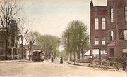
industry. During this period, the town proper of Merrimac, centered around Merrimac Square
, expanded separately from the village of Merrimacport. In 1876, Merrimac, including Merrimacport, separated from Amesbury and officially incorporated itself as a town. It is believed that the town, as well as the river that runs along its southern border, are both named for the American Indian
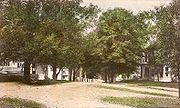
tribe that occupied the region. "Merrimac" (or Merrimack) means "swift water place" in the language of this tribe. This town center consists of the typical brick buildings and Victorian architecture
of the late-nineteenth century, and it is surrounded by much of the town's population
. Interstate 495
now divides Merrimacport from Merrimac. At the beginning of the twentieth century, as with the rest of the New England
, it went through a period of deindustrialization
as the region's industry relocated to the Midwest. The communities of the Merrimack Valley, including Merrimac, were particularly affected by this long period of economic decline and have never fully recovered.
Today, Merrimac is a typical and small New England community
. It went through numerous growth
spurts throughout the 1990s
and the beginning of the twenty-first century as it was absorbed into the Greater Lawrence metropolitan area.
, the town has a total area of 8.8 square miles (22.8 km²), of which 8.5 square miles (22 km²) is land and 0.3 square mile (0.776996433 km²), or 3.40%, is water. Merrimac is drained by the Merrimack River
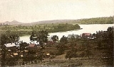
, whose north bank the town lies on. Located in the Merrimack River Valley and on the coastal plain of Massachusetts, Merrimac's land consists mainly of small, forested hills (before the twentieth century, it was mostly pasture). The town also has several ponds, streams and Lake Attitash
.
Merrimac is roughly diamond-shaped, and is bordered by Amesbury
and Lake Attitash
to the northeast, West Newbury
to the southeast, Haverhill
to the southwest, and Newton
, New Hampshire to the north and northwest. The town is 14 miles (22.5 km) northeast of Lawrence
, 30 miles (48.3 km) southeast of Manchester, New Hampshire
, and 34 miles (54.7 km) north of Boston
. Merrimac lies along Interstate 495
, with Exit 53 giving access to the town. Massachusetts Route 110 also passes through the town, just north of I-495. There are no bridges crossing the Merrimack directly into the town; the Rocks Bridge lies just to the south of town in Haverhill, and the nearest downstream crossing is the Whittier Memorial Bridge in Amesbury.
of 2000, there were 6,138 people, 2,233 households, and 1,699 families residing in the town. The population density
was 719.6 people per square mile (277.8/km²). There were 2,295 housing units at an average density of 269.1 per square mile (103.9/km²). The racial makeup of the town was 98.27% White, 0.39% African American, 0.11% Native American, 0.28% Asian, 0.29% from other races
, and 0.65% from two or more races. Hispanic or Latino of any race were 0.90% of the population.
There were 2,233 households out of which 40.6% had children under the age of 18 living with them, 62.8% were married couples
living together, 10.3% had a female householder with no husband present, and 23.9% were non-families. 19.8% of all households were made up of individuals and 9.2% had someone living alone who was 65 years of age or older. The average household size was 2.73 and the average family size was 3.16.
In the town the population was spread out with 29.0% under the age of 18, 5.0% from 18 to 24, 31.4% from 25 to 44, 23.6% from 45 to 64, and 11.0% who were 65 years of age or older. The median age was 37 years. For every 100 females there were 94.9 males. For every 100 females age 18 and over, there were 90.5 males.
The median income for a household in the town was $58,692, versus $65,401 statewide, and the median income for a family was $69,118. Males had a median income of $48,718 versus $35,325 for females. The per capita income
for the town was $24,869. About 1.9% of families and 2.7% of the population were below the poverty line, including 0.7% of those under age 18 and 7.7% of those age 65 or over.
. Three selectmen are elected to administer the government, but all major decisions, as well as many minor decisions, are handled during the town's annual town meeting, as well as special town meetings, if required. Per the constitution
of the Commonwealth of Massachusetts
, any resident of Merrimac may introduce legislation with the support of 10 registered voters.
Massachusetts. Merrimac High School operated until 1958, but closed when Pentucket Regional High School opened.
New England town
The New England town is the basic unit of local government in each of the six New England states. Without a direct counterpart in most other U.S. states, New England towns are conceptually similar to civil townships in other states, but are incorporated, possessing powers like cities in other...
in Essex County
Essex County, Massachusetts
-National protected areas:* Parker River National Wildlife Refuge* Salem Maritime National Historic Site* Saugus Iron Works National Historic Site* Thacher Island National Wildlife Refuge-Demographics:...
, Massachusetts
Massachusetts
The Commonwealth of Massachusetts is a state in the New England region of the northeastern United States of America. It is bordered by Rhode Island and Connecticut to the south, New York to the west, and Vermont and New Hampshire to the north; at its east lies the Atlantic Ocean. As of the 2010...
, United States, and on the southeastern border
Border
Borders define geographic boundaries of political entities or legal jurisdictions, such as governments, sovereign states, federated states and other subnational entities. Some borders—such as a state's internal administrative borders, or inter-state borders within the Schengen Area—are open and...
of New Hampshire
New Hampshire
New Hampshire is a state in the New England region of the northeastern United States of America. The state was named after the southern English county of Hampshire. It is bordered by Massachusetts to the south, Vermont to the west, Maine and the Atlantic Ocean to the east, and the Canadian...
, approximately 34 miles (54.7 km) northeast of Boston
Boston
Boston is the capital of and largest city in Massachusetts, and is one of the oldest cities in the United States. The largest city in New England, Boston is regarded as the unofficial "Capital of New England" for its economic and cultural impact on the entire New England region. The city proper had...
and 10 miles (16.1 km) west of the Atlantic Ocean
Atlantic Ocean
The Atlantic Ocean is the second-largest of the world's oceanic divisions. With a total area of about , it covers approximately 20% of the Earth's surface and about 26% of its water surface area...
. It is situated along the north bank of the Merrimack River
Merrimack River
The Merrimack River is a river in the northeastern United States. It rises at the confluence of the Pemigewasset and Winnipesaukee rivers in Franklin, New Hampshire, flows southward into Massachusetts, and then flows northeast until it empties into the Atlantic Ocean at Newburyport...
in the Merrimack Valley
Merrimack Valley
The Merrimack Valley is a bi-state region along the Merrimack River in the states of New Hampshire and Massachusetts, United States. The Merrimack is one of the larger waterways in the New England region and has helped define the livelihood and culture of those living along it since native...
. The population was 6,504 in 2008. Historically a manufacturing
Manufacturing
Manufacturing is the use of machines, tools and labor to produce goods for use or sale. The term may refer to a range of human activity, from handicraft to high tech, but is most commonly applied to industrial production, in which raw materials are transformed into finished goods on a large scale...
center, it has long since become a largely residential community. It is part of the Greater Boston
Greater Boston
Greater Boston is the area of the Commonwealth of Massachusetts surrounding the city of Boston. Due to ambiguity in usage, the size of the area referred to can be anywhere between that of the metropolitan statistical area of Boston and that of the city's combined statistical area which includes...
metropolitan area.
History
England
England is a country that is part of the United Kingdom. It shares land borders with Scotland to the north and Wales to the west; the Irish Sea is to the north west, the Celtic Sea to the south west, with the North Sea to the east and the English Channel to the south separating it from continental...
in 1638 as a part of Salisbury
Salisbury, Massachusetts
Salisbury is a town in Essex County, Massachusetts, United States. The population was 7,827 at the 2000 census. The community is a popular summer resort beach town situated on the Atlantic Ocean north of Boston on the New Hampshire border....
and later as a part of Amesbury
Amesbury, Massachusetts
Amesbury is a city in Essex County, Massachusetts, United States. Though it officially became a city in 1996, its formal name remains "The Town of Amesbury." In 1890, 9798 people lived in Amesbury; in 1900, 9473; in 1910, 9894; in 1920, 10,036; and in 1940, 10,862. The population was 16,283 at...
around the village
Village
A village is a clustered human settlement or community, larger than a hamlet with the population ranging from a few hundred to a few thousand , Though often located in rural areas, the term urban village is also applied to certain urban neighbourhoods, such as the West Village in Manhattan, New...
of Merrimacport
Merrimacport, Massachusetts
Merrimacport is an unincorporated village and the oldest section of the town of Merrimac, Massachusetts, located along the Merrimack River.Settled in 1638, it began as a fishing village, and was long a part of the section of Amesbury, Massachusetts known as West Amesbury. During the Industrial...
, it was known throughout the seventeenth and eighteenth centuries as an agricultural and fishing
Fishing
Fishing is the activity of trying to catch wild fish. Fish are normally caught in the wild. Techniques for catching fish include hand gathering, spearing, netting, angling and trapping....
community, with a small amount of shipbuilding
Shipbuilding
Shipbuilding is the construction of ships and floating vessels. It normally takes place in a specialized facility known as a shipyard. Shipbuilders, also called shipwrights, follow a specialized occupation that traces its roots to before recorded history.Shipbuilding and ship repairs, both...
. When Amesbury separated from Salisbury in 1666, Merrimac was referred to as the West Parish of Amesbury, or simply West Amesbury, although it was unincorporated.
In the nineteenth century, benefiting from a manufacturing boom following the establishment of some of the first planned industrial
Industry
Industry refers to the production of an economic good or service within an economy.-Industrial sectors:There are four key industrial economic sectors: the primary sector, largely raw material extraction industries such as mining and farming; the secondary sector, involving refining, construction,...
cities in the United States, nearby Lawrence
Lawrence, Massachusetts
Lawrence is a city in Essex County, Massachusetts, United States on the Merrimack River. According to the 2010 U.S. Census, the city had a total population of 76,377. Surrounding communities include Methuen to the north, Andover to the southwest, and North Andover to the southeast. It and Salem are...
and Lowell
Lowell, Massachusetts
Lowell is a city in Middlesex County, Massachusetts, USA. According to the 2010 census, the city's population was 106,519. It is the fourth largest city in the state. Lowell and Cambridge are the county seats of Middlesex County...
, Merrimac came to be known worldwide for its horse-drawn carriage
Carriage
A carriage is a wheeled vehicle for people, usually horse-drawn; litters and sedan chairs are excluded, since they are wheelless vehicles. The carriage is especially designed for private passenger use and for comfort or elegance, though some are also used to transport goods. It may be light,...
industry. During this period, the town proper of Merrimac, centered around Merrimac Square
Merrimac Square
Merrimac Square is located in the center of the town of Merrimac, Massachusetts. It is the commercial, cultural and historical center of the town....
, expanded separately from the village of Merrimacport. In 1876, Merrimac, including Merrimacport, separated from Amesbury and officially incorporated itself as a town. It is believed that the town, as well as the river that runs along its southern border, are both named for the American Indian
Native Americans in the United States
Native Americans in the United States are the indigenous peoples in North America within the boundaries of the present-day continental United States, parts of Alaska, and the island state of Hawaii. They are composed of numerous, distinct tribes, states, and ethnic groups, many of which survive as...
tribe that occupied the region. "Merrimac" (or Merrimack) means "swift water place" in the language of this tribe. This town center consists of the typical brick buildings and Victorian architecture
Victorian architecture
The term Victorian architecture refers collectively to several architectural styles employed predominantly during the middle and late 19th century. The period that it indicates may slightly overlap the actual reign, 20 June 1837 – 22 January 1901, of Queen Victoria. This represents the British and...
of the late-nineteenth century, and it is surrounded by much of the town's population
Population
A population is all the organisms that both belong to the same group or species and live in the same geographical area. The area that is used to define a sexual population is such that inter-breeding is possible between any pair within the area and more probable than cross-breeding with individuals...
. Interstate 495
Interstate 495 (Massachusetts)
Interstate 495 is the designation of an Interstate Highway half-beltway in Massachusetts. It was the longest auxiliary Interstate Highway of its kind—measuring 120.74 miles —until 1996, when the PA Route 9 section of the Pennsylvania Turnpike was redesignated as Interstate 476, making it about ...
now divides Merrimacport from Merrimac. At the beginning of the twentieth century, as with the rest of the New England
New England
New England is a region in the northeastern corner of the United States consisting of the six states of Maine, New Hampshire, Vermont, Massachusetts, Rhode Island, and Connecticut...
, it went through a period of deindustrialization
Deindustrialization
Deindustrialization is a process of social and economic change caused by the removal or reduction of industrial capacity or activity in a country or region, especially heavy industry or manufacturing industry. It is an opposite of industrialization.- Multiple interpretations :There are multiple...
as the region's industry relocated to the Midwest. The communities of the Merrimack Valley, including Merrimac, were particularly affected by this long period of economic decline and have never fully recovered.
Today, Merrimac is a typical and small New England community
Community
The term community has two distinct meanings:*a group of interacting people, possibly living in close proximity, and often refers to a group that shares some common values, and is attributed with social cohesion within a shared geographical location, generally in social units larger than a household...
. It went through numerous growth
Population growth
Population growth is the change in a population over time, and can be quantified as the change in the number of individuals of any species in a population using "per unit time" for measurement....
spurts throughout the 1990s
1990s
File:1990s decade montage.png|From left, clockwise: The Hubble Space Telescope floats in space after it was taken up in 1990; American F-16s and F-15s fly over burning oil fields and the USA Lexie in Operation Desert Storm, also known as the 1991 Gulf War; The signing of the Oslo Accords on...
and the beginning of the twenty-first century as it was absorbed into the Greater Lawrence metropolitan area.
Geography
According to the United States Census BureauUnited States Census Bureau
The United States Census Bureau is the government agency that is responsible for the United States Census. It also gathers other national demographic and economic data...
, the town has a total area of 8.8 square miles (22.8 km²), of which 8.5 square miles (22 km²) is land and 0.3 square mile (0.776996433 km²), or 3.40%, is water. Merrimac is drained by the Merrimack River
Merrimack River
The Merrimack River is a river in the northeastern United States. It rises at the confluence of the Pemigewasset and Winnipesaukee rivers in Franklin, New Hampshire, flows southward into Massachusetts, and then flows northeast until it empties into the Atlantic Ocean at Newburyport...
, whose north bank the town lies on. Located in the Merrimack River Valley and on the coastal plain of Massachusetts, Merrimac's land consists mainly of small, forested hills (before the twentieth century, it was mostly pasture). The town also has several ponds, streams and Lake Attitash
Lake Attitash
Lake Attitash is a lake located on the border of Merrimac, Massachusetts and Amesbury, Massachusetts, and constitutes at least a portion of Amesbury's water supply....
.
Merrimac is roughly diamond-shaped, and is bordered by Amesbury
Amesbury, Massachusetts
Amesbury is a city in Essex County, Massachusetts, United States. Though it officially became a city in 1996, its formal name remains "The Town of Amesbury." In 1890, 9798 people lived in Amesbury; in 1900, 9473; in 1910, 9894; in 1920, 10,036; and in 1940, 10,862. The population was 16,283 at...
and Lake Attitash
Lake Attitash
Lake Attitash is a lake located on the border of Merrimac, Massachusetts and Amesbury, Massachusetts, and constitutes at least a portion of Amesbury's water supply....
to the northeast, West Newbury
West Newbury, Massachusetts
West Newbury is a town in Essex County, Massachusetts, United States. Situated on the Merrimack River, its population was 4,450 at the 2006 census. Along with neighboring Merrimac and Groveland, it is part of the Pentucket Regional School District....
to the southeast, Haverhill
Haverhill, Massachusetts
Haverhill is a city in Essex County, Massachusetts, United States. The population was 60,879 at the 2010 census.Located on the Merrimack River, it began as a farming community that would evolve into an important industrial center, beginning with sawmills and gristmills run by water power. In the...
to the southwest, and Newton
Newton, New Hampshire
Newton is a town in Rockingham County, New Hampshire, United States. The population was 4,603 at the 2010 census.- History :The sixth town to be granted from the Masonian land purchase of 1746, Newton was originally part of Salisbury, Massachusetts; later, part of Amesbury, Massachusetts; then...
, New Hampshire to the north and northwest. The town is 14 miles (22.5 km) northeast of Lawrence
Lawrence, Massachusetts
Lawrence is a city in Essex County, Massachusetts, United States on the Merrimack River. According to the 2010 U.S. Census, the city had a total population of 76,377. Surrounding communities include Methuen to the north, Andover to the southwest, and North Andover to the southeast. It and Salem are...
, 30 miles (48.3 km) southeast of Manchester, New Hampshire
Manchester, New Hampshire
Manchester is the largest city in the U.S. state of New Hampshire, the tenth largest city in New England, and the largest city in northern New England, an area comprising the states of Maine, New Hampshire, and Vermont. It is in Hillsborough County along the banks of the Merrimack River, which...
, and 34 miles (54.7 km) north of Boston
Boston
Boston is the capital of and largest city in Massachusetts, and is one of the oldest cities in the United States. The largest city in New England, Boston is regarded as the unofficial "Capital of New England" for its economic and cultural impact on the entire New England region. The city proper had...
. Merrimac lies along Interstate 495
Interstate 495 (Massachusetts)
Interstate 495 is the designation of an Interstate Highway half-beltway in Massachusetts. It was the longest auxiliary Interstate Highway of its kind—measuring 120.74 miles —until 1996, when the PA Route 9 section of the Pennsylvania Turnpike was redesignated as Interstate 476, making it about ...
, with Exit 53 giving access to the town. Massachusetts Route 110 also passes through the town, just north of I-495. There are no bridges crossing the Merrimack directly into the town; the Rocks Bridge lies just to the south of town in Haverhill, and the nearest downstream crossing is the Whittier Memorial Bridge in Amesbury.
Demographics
As of the censusCensus
A census is the procedure of systematically acquiring and recording information about the members of a given population. It is a regularly occurring and official count of a particular population. The term is used mostly in connection with national population and housing censuses; other common...
of 2000, there were 6,138 people, 2,233 households, and 1,699 families residing in the town. The population density
Population density
Population density is a measurement of population per unit area or unit volume. It is frequently applied to living organisms, and particularly to humans...
was 719.6 people per square mile (277.8/km²). There were 2,295 housing units at an average density of 269.1 per square mile (103.9/km²). The racial makeup of the town was 98.27% White, 0.39% African American, 0.11% Native American, 0.28% Asian, 0.29% from other races
Race (United States Census)
Race and ethnicity in the United States Census, as defined by the Federal Office of Management and Budget and the United States Census Bureau, are self-identification data items in which residents choose the race or races with which they most closely identify, and indicate whether or not they are...
, and 0.65% from two or more races. Hispanic or Latino of any race were 0.90% of the population.
There were 2,233 households out of which 40.6% had children under the age of 18 living with them, 62.8% were married couples
Marriage
Marriage is a social union or legal contract between people that creates kinship. It is an institution in which interpersonal relationships, usually intimate and sexual, are acknowledged in a variety of ways, depending on the culture or subculture in which it is found...
living together, 10.3% had a female householder with no husband present, and 23.9% were non-families. 19.8% of all households were made up of individuals and 9.2% had someone living alone who was 65 years of age or older. The average household size was 2.73 and the average family size was 3.16.
In the town the population was spread out with 29.0% under the age of 18, 5.0% from 18 to 24, 31.4% from 25 to 44, 23.6% from 45 to 64, and 11.0% who were 65 years of age or older. The median age was 37 years. For every 100 females there were 94.9 males. For every 100 females age 18 and over, there were 90.5 males.
The median income for a household in the town was $58,692, versus $65,401 statewide, and the median income for a family was $69,118. Males had a median income of $48,718 versus $35,325 for females. The per capita income
Per capita income
Per capita income or income per person is a measure of mean income within an economic aggregate, such as a country or city. It is calculated by taking a measure of all sources of income in the aggregate and dividing it by the total population...
for the town was $24,869. About 1.9% of families and 2.7% of the population were below the poverty line, including 0.7% of those under age 18 and 7.7% of those age 65 or over.
Government
Merrimac, like all New England towns, is governed by the New England town meeting form of government, a kind of participatory direct democracyDirect democracy
Direct democracy is a form of government in which people vote on policy initiatives directly, as opposed to a representative democracy in which people vote for representatives who then vote on policy initiatives. Direct democracy is classically termed "pure democracy"...
. Three selectmen are elected to administer the government, but all major decisions, as well as many minor decisions, are handled during the town's annual town meeting, as well as special town meetings, if required. Per the constitution
Constitution
A constitution is a set of fundamental principles or established precedents according to which a state or other organization is governed. These rules together make up, i.e. constitute, what the entity is...
of the Commonwealth of Massachusetts
Massachusetts
The Commonwealth of Massachusetts is a state in the New England region of the northeastern United States of America. It is bordered by Rhode Island and Connecticut to the south, New York to the west, and Vermont and New Hampshire to the north; at its east lies the Atlantic Ocean. As of the 2010...
, any resident of Merrimac may introduce legislation with the support of 10 registered voters.
Education
The following schools serve the town of Merrimac. All regional schools, however, are located in neighboring West NewburyWest Newbury, Massachusetts
West Newbury is a town in Essex County, Massachusetts, United States. Situated on the Merrimack River, its population was 4,450 at the 2006 census. Along with neighboring Merrimac and Groveland, it is part of the Pentucket Regional School District....
Massachusetts. Merrimac High School operated until 1958, but closed when Pentucket Regional High School opened.
- Frederick N. Sweetsir School - named for a doctor who practiced in Merrimac
- Helen R. Donaghue School - named for a former principal of the school
- Pentucket Regional Middle School
- Pentucket Regional High School
- Pentucket Regional School DistrictPentucket Regional School DistrictPentucket Regional School District is a three town regional school district. Elementary schools are located in each town, and the high school campus is located mostly in West Newbury, Massachusetts, USA and partially in Groveland, Massachusetts, USA. The schools teach the languages French, Spanish,...
Sites of interest
- Lake AttitashLake AttitashLake Attitash is a lake located on the border of Merrimac, Massachusetts and Amesbury, Massachusetts, and constitutes at least a portion of Amesbury's water supply....
(and Indian Head Park) - Merrimacport
- Merrimac SquareMerrimac SquareMerrimac Square is located in the center of the town of Merrimac, Massachusetts. It is the commercial, cultural and historical center of the town....
- Merrimac Town ForestMerrimac Town ForestThe Merrimac Town Forest is a heavily-forested area of the western half of the town of Merrimac, Massachusetts, west of Merrimac Square and north of Interstate 495, which was set aside as a town forest....
(see town forest) - Merrimac Training Field (see training fieldTraining fieldIn the U.S. region of New England, many towns and cities have kept and maintained the training fields that served as the training grounds for soldiers, militia, and townspeople during former wars, including the American War of Independence, the War of 1812, and the American Civil War.Today, these...
) - Stevens Field
- The Merrimac Public Library is a libraryLibraryIn a traditional sense, a library is a large collection of books, and can refer to the place in which the collection is housed. Today, the term can refer to any collection, including digital sources, resources, and services...
in Merrimac, Massachusetts. It belongs to the Merrimack Valley Library Consortium.
Annual events
Merrimac is home to several regional events:- The Merrimac Santa Parade
- Merrimac Old Home DaysMerrimac Old Home Days-Features:Events include Miniature Golf, live animals, and an inflatable slide.Traditionally, the teachers of the nearby schools go in a Dunk Tank for children to throw balls to try to knock them in water.-External links:*...
Notable residents
- Richard P. Gabriel, computer scientist
- Ephraim MorseEphraim MorseEphraim W. Morse was an early settler of the city of San Diego, and was partially responsible for many of its expansions as a city, such as attracting the Atchison, Topeka and Santa Fe Railway and proposing Balboa Park.-Early life:Morse was born in 1823 in West Amesbury, Massachusetts...
, developer of San DiegoSan Diego, CaliforniaSan Diego is the eighth-largest city in the United States and second-largest city in California. The city is located on the coast of the Pacific Ocean in Southern California, immediately adjacent to the Mexican border. The birthplace of California, San Diego is known for its mild year-round... - George W. WeymouthGeorge W. WeymouthGeorge Warren Weymouth was a U.S. Representative from Massachusetts.Born in West Amesbury , Massachusetts, Weymouth attended the public schools and the Merrimac High School. He moved to Fitchburg in 1882 and engaged in the carriage business...
, congressman - William WheelwrightWilliam WheelwrightWilliam Wheelwright was a businessman who played an essential role in the development of steamboat and train transportation in Chile and other parts of South America...
, steamboat & railroad developer
External links
- Town of Merrimac, Massachusetts
- Merrimac Public Library
- Merrimac Citizens For A Strong Community
- 1872 Map of Amesbury (Merrimac was then known as West Amesbury) from plate 9 of the 1872 Atlas of Essex County.
- 1884 Map of Merrimac from plate 172 of the 1884 Atlas of Essex County.
- 1884 Map of Merrimacport from plate 154 of the 1884 Atlas of Essex County.
- 1884 Map of Merrimac Village from plate 151 of the 1884 Atlas of Essex county.
- 1888 Merrimac article by William T. Davis on pages 1535-1556 in Volume II of the History of Essex County Massachusetts with Biographical Sketches, published by D. Hamilton Hurd in 1888.
- 1922 Merrimac article Chapter 30 on pages 313-318 of Volume I of the Municipal History of Essex County, edited by Benjamin F. Arrington, published 1922 by Lewis Historical Publishing.
- Merrimac Library Homepage
- MVLC Homepage